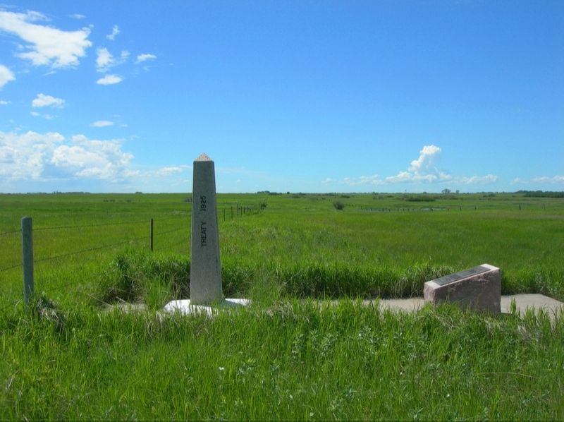
The monument erected here marks the intersection of the boundary between Manitoba and Saskatchewan with the International Boundary and was placed by joint effort of the International Boundary Commission and the Manitoba-Saskatchewan Boundary . . . — — Map (db m285368) HM
This plaque and gateway are dedicated to the memory of the pioneers of the Winlaw District who with faith and foresight planned this church and cemetery in 1886. Erected on land donated by I. Guthrie, Winlaw Presbyterian Church
was officially . . . — — Map (db m286081) HM
Erected to Commemorate
Winlaw School and District No. 143 Organized 1888.
Classes held in Winlaw Church until school built
1900, S.E. 20. Moved to this
site 1925. Closed 1958. — — Map (db m286082) HM
The piles of stone and mud scattered along the valley are the remains of chimneys which stood for many years to mark the sites of Metis cabins, trading posts and a police post. From the middle decades of the nineteenth century Metis hunters and . . . — — Map (db m205165) HM
For more than 50 years John Macoun was one of the leading naturalists in Canada. In 1872 he was appointed botanist to the Sandford Fleming Expedition. He died in 1920 after 27 years as Assistant Director and Naturalist to the Geological Survey of . . . — — Map (db m205152) HM
Pine Cree Park
Originally Bakers Coulee named after its founder Everett Baker
E. Baker was instrumental in forming the park which became part of the Saskatchewan Regional Park system in 1970. — — Map (db m205153) HM
[English] No. 23 E.F.T.S. was based here during 1942 to 1945 under the British Commonwealth Air Training Plan. Aircrew trained here were part of the 131,553 aircrew trained in Canada for the fight against tyranny. . . . — — Map (db m211676) HM
Born 20 April, 1908, at Fort Battleford, the youngest son of Staff Sergeant Frederic Walter Light, North West Mounted Police, and Mrs. Light (Nee Phyllis Young), he attended Battleford elementary and secondary schools. A student of the celebrated . . . — — Map (db m289900) HM
Constructed of local brick in 1877-78 this was the first land registry office in the North-West Territories and the oldest known brick building in Saskatchewan. Containing records of all private and public land in the Territories, this office . . . — — Map (db m212000) HM
Here in July 1876, Superintendent James Walker established a post of the North-West Mounted Police in the heart of the Cree country. "The Fort" grew to a strength of 200. During the uprising of 1885 it gave refuge to more than 400 people . . . — — Map (db m202597) HM
"It must be the largest and finest house in all the land." Lt.-Gov. David Laird Battleford was the capital of the Northwest Territories from 1876 to 1883. From here at Government House, the territorial government managed a vast expanse of . . . — — Map (db m211931) HM
Between 1877 and 1883, the North-West Territories, an area then comprising over two-thirds of Canada, were administered from this location. As the centre of government for this region, Government House contained the offices and chambers of the . . . — — Map (db m211919) HM
In 1876 Government House, the seat of government for the North-West Territories, was constructed. The North-West Council held its annual sessions here in 1878, 1879 and 1881. In 1883, the seat of government was transferred to Regina. From 1883 to . . . — — Map (db m211929) HM
Government House became an industrial school for First Nations youth when the capital of the Northwest Territories shifted to Regina in 1883. Operated by the Church of England, Battleford Industrial School was one of more than a dozen such schools . . . — — Map (db m211933) HM
The Land Registry Office building is the only original Government Ridge structure still standing. Constructed in 1877, the registry office recorded all land sales in the Northwest Territories. The outside walls are almost half a metre thick and one . . . — — Map (db m211999) HM
Between 28 March and 24 April 1885 almost 600 people — most of the white and Métis population of the area — took refuge in the North-West Mounted Police post here in anticipation of a general Indian uprising in support of Riel. Although . . . — — Map (db m220990) HM
The North-West Territories Act of 1875 provided for the administration of the territories by a resident Lieutenant-Governor and an appointed Council. The North-West Council held its first session in 1877 at Fort Livingstone while permanent . . . — — Map (db m289980) HM
Government House spent most of its remaining years in the care of Oblate priests, who purchased the site in 1931 and turned it into a seminary called the Oblate House of Studies. St. Thomas College, a boarding high school for students in grades 9 . . . — — Map (db m211941) HM
[English] In February 1876 Battleford, on the projected rail and telegraph lines, was chosen as the site of the new capital of the North-West Territories, and that summer construction was begun on quarters for the . . . — — Map (db m211899) HM
When the Seventh-day Adventist Church agreed to rent the Government House property for $5 per year in 1915, it may have sounded like a wonderful deal. However, the 10-year arrangement left the church responsible for costly maintenance and any . . . — — Map (db m211939) HM
Telegraph Flat was named in 1876 when the Dominion Telegraph Company opened its western terminus office on this site. In the same year the Hudson's Bay Company built a nearby trading post, and the North-West Mounted Police established its . . . — — Map (db m289967) HM
The landmark that came to be known as "Old Government House" burned to the ground on June 7, 2003, a victim of vandalism. It was a sad end to a historic structure created as a seat of government but used far longer as a place of learning. Over a . . . — — Map (db m211942) HM
The Saskatchewan Herald was founded on this site in 1878 by Patrick G. Laurie. It was the first newspaper in the Territories. Laurie brought in his printing press by ox-cart from Fort Garry, a trek of 72 days. His own publisher, editor, . . . — — Map (db m289983) HM
1981 Sask. Provincial High School Champion Third on BCHS Anita Barber Team 1987 Sask. Provincial Scott Tournament of Hearts Champion Third on Kathy Fahlman Team 1991 Sask. Provincial Scott Tournament of Hearts Champion 1992 Sask. . . . — — Map (db m211858) HM
The dream of a playground and park as a setting for Biggar’s new school began in 1998. A committee representing the Board of Trustees, the P.T.A., the teaching staff and senior students began to plan the park while others investigated sources of . . . — — Map (db m211799) HM
Sandra was born on June 11, 1963, in Biggar, Saskatchewan. She was the daughter of Art and Shirley Schmirler, and sister to Carol and Beverley. Sandra received all of her elementary and high school education in Biggar. She excelled in a variety of . . . — — Map (db m211800) HM
1981 Saskatchewan High School Girl’s Curling Gold Medal winner as Third on the BCHS Anita Silvernagle team 1987 Provincial Scott Tournament of Hearts champion as Third on the Kathy Fahlman team 1991 Provincial Scott Tournament of . . . — — Map (db m211797) HM
The 250 mile trail linking Wood Mountain with Fort Qu’Appelle passed this site. From about 1850, Indians, hunters, traders, missionaries, mounted police and pioneers transported pelts, pemmican and provisions over its length. From Wood Mountain . . . — — Map (db m203787) HM
Domes of the East crown this beautiful church of distinctive Byzantine architecture.
Dedicated to the founders and settlers of the Ukrainian Orthodox Church of St. Elia - Wroxton.
They sifted into Saskatchewan in the late 1890's. . . . — — Map (db m289822) HM
In memory of 1914 — 1918 Askin R. • Bowden J. S. • Green H. • McCrady R. E. • McGillivray G. A. Perkins F. G. • Perkins T. A. • Reid D. P. • Walker F. Erected & unveiled by Milestone Community Club June 3, 1928. 1939 . . . — — Map (db m209030) WM
Dedicated to the pioneers who built the
schools and former teachers and students.
Brown No. 1329
Dale No. 1391
Defiance No. 2612
Fiaata No. 1744
Gilbertson No. 1231
Green Mount No. 1702
Hagen No. 1651
Hayland No. 4139
Kolke No. . . . — — Map (db m293849) HM
The unusual circular lake seen to the west, was created as the
result of collapses in the geological formation beneath the lake. A
potash-rich, prairie evaporite salt formation 915 metres below the
surface underlies most of southern . . . — — Map (db m286089) HM
The first block Ukrainian settlement in Saskatchewan was established in 1897 when 180 families arrives in the Canora district from western Ukraine. Ottawa had specified that earlier Ukrainian immigrants first settle in Alberta and Manitoba. . . . — — Map (db m8492) HM
In honour of all the veterans of Chaplin and surrounding areas who served both in Canada and overseas in past conflicts and peace keeping services around the world May their sacrifices never be forgotten They gave their all Dedicated this the . . . — — Map (db m201010) WM
[English] Saskatoon was initially bypassed by two transcontinental railways but its growing significance as the major distribution centre for north-central Saskatchewan resulted in the convergence of three separate lines in the city by 1908. . . . — — Map (db m196883) HM
Firehall No. 3 was built in 1911, along with an adjacent watertower, to serve an ever expanding city and was officially opened on January 6th, 1912. The first run occurred on February 17th, 1912 to put out a fire caused by boiling tar in a local . . . — — Map (db m196884) HM
Built by the Texaco Oil Company in 1929, this building was an early Saskatoon landmark. Originally known as West Side Service Station, the name was changed to Little Chief Service Station in 1943. Frank Carr, who operated the station between 1947 . . . — — Map (db m203733) HM
This is the oldest provincial government office building in Saskatoon. It was erected in 1909 from designs by Storey and van Egmond, the prominent Regina architects. By 1911 the structure was doubled in size, reflecting the rapid expansion in urban . . . — — Map (db m196885) HM
[English] People have occupied the Plains of North America for thousands of years. Here at Wanuskewin many archaeological features have been identified, representing most of the known elements which characterize Northern Plains . . . — — Map (db m203726) HM
As one of the first buildings constructed on campus, the College Building reflects the prominent role Agriculture Education was to play at the newly created University of Saskatchewan. Originally designed to house the College of Agriculture, this . . . — — Map (db m220898) HM
[English] This handsome structure stands as the centrepiece of the finest grouping of university buildings in Canada designed in the Collegiate Gothic, a style widely used for institutions of higher learning throughout North . . . — — Map (db m220952) HM
• Established in Craik in 1911 under management of R.H. Frazee of Toronto • Lot purchased in 1917 for construction of bank building • Royal Bank officials stated in July 1918 that "It will be a two story brick building and modern in every . . . — — Map (db m206990) HM
”Let those not be forgotten who bravely took part in the fight for Democracy.” Anderson, Carl • Armstrong, Allan • Armstrong, Douglas • Armstrong, Kenneth • Bachorcik, Paul • Bachorcik, Steve • Barbour, Archie • Barnstable, Orville • Berg, . . . — — Map (db m203767) WM
[Français] Pédagogue remarquable, Mademoiselle Dorval fut la première institutrice diplômée de la Saskatchewan. Originaire du Québec, elle s'établit dans l'Ouest en 1877, devint membre de l'Ordre de Saint-François et consacra le . . . — — Map (db m202598) HM
This east-west trail, roughly followed the Qu'Appelle Valley, beginning near the elbow of the South Saskatchewan River and extending eastward near the Saskatchewan-Manitoba border. Other important trail routes connected at various points on this . . . — — Map (db m211796) HM
World War I R. Brown • J. Geal • P.A. Heath • T.M. Hordern • J. Hordern M.N. McCrimmon • R.P. McCordick • H. McMillan T.C. Waters • A.J. Williams World War II L. Bedard • B. Koop . . . — — Map (db m211795) WM
The engine pictured on this sign is Canadian National #1158. Built by the Montreal Locomotive Works in April 1913, this engine was one of fifty G-16-a class constructed during the years 1912-1913. ——————————— They were built for Canadian National . . . — — Map (db m212315) HM
In 1931, the coal miners of South East Saskatchewan organized to improve conditions in the mines for themselves and their families. On September 29th, on this site brothers Peter Markunas, Nick Nargan and Julian Gryshko died in the struggle and . . . — — Map (db m203782) HM
This building, completed in 1930, is the last court house designed by Saskatchewan’s Provincial Architect, Maurice Sharon. Faced with Estevan pressed brick, it is a fine example of the Colonial Revival style. In 1931, miners in the Estevan area . . . — — Map (db m203775) HM
One of the most important early trails passed at this point. Linking the early Metis settlements at Wood Mountain and Fort Qu'Appelle, it was in frequent use from the 1860's. In 1881 Sitting Bull, the famous Sioux Leader. Passed over this trail . . . — — Map (db m205104) HM
Preserve Our Heritage
On October 3, 1889, New Stockholm Church, the first Swedish Lutheran congregation in Canada, was organized in this colony.
In 1893, the first church was built of logs hauled by oxen from Qu'Appelle Valley. . . . — — Map (db m288796) HM
All Distances Noted Herein are from this Marker
In July 1, 1886, a group of immigrants from Sweden and Norway arrived at their preselected homesteads located south and east of here. This was the first permanent Swedish
Settlement in the . . . — — Map (db m288798) HM
Arriving in Gull Lake in 1917-18, Wong Guy came to a town in turmoil. The Spanish Flu was raging, and despite being a brand new resident to the town, he took it upon himself to cook for the patients at the old brick school, which doubled as an . . . — — Map (db m201268) HM
In 1914, W.T. Smith built the largest barn on the North American continent. The barn was by a contractor from Brandon, Manitoba. The barn was 128 feet by 400 feet by 60 feet high.
Material used for construction:
*875,000 board feet of . . . — — Map (db m288973) HM
St. John's School
NE 1/4 4-21-26 W3M
St. John's School was built in 1924. The student count at that time was 38.
St. John's was the only parochial school in the Missouri Synod of the Lutheran
Church in Saskatchewan. In 1942 St. . . . — — Map (db m286086) HM
A city reveals its unique past through its historic buildings. This building is one of several in the downtown core that were constructed before 1920. We invite you to explore its history.
1912-1975 Postal Service
1912-1932 . . . — — Map (db m196887) HM
A city reveals its unique past through its historic buildings. This building is one of several in the downtown core that were constructed before 1920. We invite you to explore its history.
The water tower was constructed from 1914 . . . — — Map (db m196886) HM
This historic building, erected in 1912, expanded in 1955, housed the post office until 1975. Through the years it has been the site for many other government offices:
1912-32 Customs office on second floor which included the Records and . . . — — Map (db m196889) HM
[English] Constructed in 1911, this building is typical of the post offices that were erected by the Department of Public Works in smaller urban centres throughout Canada at the beginning of the 20th century. The quality of the design, with . . . — — Map (db m196890) HM
The Bell Farm once occupied the surrounding district. It was controlled by the Qu’appelle Valley Farming Company and managed by Major W. R. Bell. Between 1882 and 1889 the company settled more than 100 tenant farmers on 53,000 acres. Farming was . . . — — Map (db m200759) HM
In 1882 the Qu'Appelle Valley Farming Company launched an ambitious 53,000 acre (21,500 hectare) corporate farming enterprise in the Indian Head district. The operation quickly became known as the Bell Farm, after the company's major shareholder . . . — — Map (db m200761) HM
In 1925 Provincial Architect Maurice Sharon developed a standard plan for judicial buildings in smaller urban centres. Half the size of his previous court houses, these structures were erected at Gravelbourg (1926), Shaunavon and Wynyard (1927), . . . — — Map (db m205157) HM
[Front]
Memoriam
To the
memory
of the gallant
men of Strongfield
who laid down their
lives on the field
of battle while
upholding the cause
of
freedom and justice
[Side]
World War I
1914 – 1918
F.W. . . . — — Map (db m196902) WM
The beautiful Qu’Appelle Valley was formed by the waters of Glacial Lake Regina and the South Saskatchewan River which cut into the deposits left by the glacier to form the valley. Glacial Lake Regina was formed along a part of the front of a . . . — — Map (db m211647) HM
Cypress Hills Massacre National Historic Site
Cypress Hills Massacre National Historic Site was designated in 2006, and commemorates the memory and legacy of the Nakoda people who died there at the hands of wolf hunters and whiskey . . . — — Map (db m289891) HM
Born at Prescott, Upper Canada, James Morrow Walsh was appointed a Superintendent of the North-West Mounted Police in 1873. He recruited, trained and led part of the new police force and held commands at Fort Walsh, which he founded in . . . — — Map (db m289889) HM
On May 23, 1873 the Canadian Parliament passed a bill to form the North West Mounted Police. This force might not have became a reality except that on June 1, 1873 a small group of whites attacked an Indian encampment in the Cypress Hills [near . . . — — Map (db m202631) HM
Although the railway from Regina to Prince Albert was completed by 1890, the area between Saskatoon and the Qu’Appelle failed to attract large numbers of settlers. In 1902, a syndicate was formed in Minneapolis. Incorporated as the Saskatchewan . . . — — Map (db m211789) HM
The Village of Cochin is named after Father Louis Cochin, a pioneer missionary among the Cree Indians. For many years he resided among the Indians who wintered on the shores of Jackfish Lake. Fr. Cochin is best remembered as the priest who was . . . — — Map (db m211900) HM
1980To commemorate the original Meota School erected in 1914. The two story building was built of red brick from the Meota Brickyard. For 60 years it was used continuously and for a number of years had grades from 1-12. It was demolished in 1974 . . . — — Map (db m211889) HM
In Memory Of Pte. George Spencer • Pte. Edward J. Foster • Pte. Charles Mann • Pte. Herbert Green • Pte. Fredrick R. Henderson • Pte. Alfred E. Brown • Pte. Robert J. Thompson • Lce. Cpl. Charles Lancaster • Capt. Weslesleg T. W. Long • Pte. James . . . — — Map (db m211882) WM
To commemorate one hundred years of Confederation July 1, 1867 — July 1, 1967 the following projects were constructed in Crescent Park Art Museum • Outdoor Swimming Pool • Natatorium Renovations • Park Lighting • Park Sprinkling System • Landscape . . . — — Map (db m289134) HM
The opening of Moose Jaw's central fire hall in 1910 was a long-awaited event. The fire hall was designed in 1907 but construction was delayed when city council spent two years searching for the right building site.
At the time of its opening, . . . — — Map (db m196929) HM
Architect: David Ewart, Ottawa • Contractor: McDiarmid & Co., Winnipeg
The Dominion of Canada's Chief Architect adapted his standard Public Building design (similar buildings remain in Vancouver, Lethbridge and Regina) to create a . . . — — Map (db m196925) HM
Architects: Sholto Smith, Moose Jaw • W.A. Elliott, Brandon
Contractor: Navin Brothers
After a 2-year delay in building, while city council searched for an appropriate site, the Fire Hall was constructed featuring a 60-foot hose . . . — — Map (db m196928) HM
When CPR construction reached here in September 1882, this view was part of a hay flat in the broad valley of Thunder Creek.
Main Street divided the two sections of land reserved for the Moose Jaw townsite. In the beginning, the thoroughfare “was . . . — — Map (db m196924) HM
[left side] Originally constructed by the Royal Bank of Canada in 1914, at a cost of $100,000, this terra cotta clad Beaux-Arts structure subsequently served for a time as home to the Bank of Montreal until 2008, when it was . . . — — Map (db m288898) HM
The Moose Jaw courthouse, completed in January 1909, is the oldest continuously functioning provincial court building in Saskatchewan. It replaced an earlier wood frame Court House at High Street and 9th Avenue which was built in 1893 and demolished . . . — — Map (db m288976) HM
Moose Jaw Court House
This building is the first example of the system of new
district facilities commissioned by the Government of
Saskatchewan after the formation of the province in
1905. Completed in 1909, it is atypical of . . . — — Map (db m288977) HM
Private George Price was born on December 15th 1892 in Kings County, Nova Scotia. As a young man he moved to Moose Jaw, Saskatchewan. He enlisted in the 210th Infantry Battalion (Frontiersmen), Canadian Expeditionary Force (C.E.F.) in Moose Jaw on . . . — — Map (db m202457) HM
Architect: Reid & McAlpine, Moose Jaw • Contractor: Peter Lyall & Sons, Montreal
In1911, the Andrew Carnegie Foundation, skeptical of Moose Jaw's population claims, refused a request for a $50,000 library grant. Undaunted, the city . . . — — Map (db m196926) HM
Morse School District #1921 Organized 1907 Morse School built in 1912. Architects: Reilly, Dawson, Hancock & Reilly Contractor: J.H. Leeby Bell moved from 1908 school to present belfry. Florence Wood and Leslie Ogden first to graduate in 1924. . . . — — Map (db m201011) HM
The City of North Battleford is pleased to honour the many citizens who have served our country in the armed conflicts throughout our history. Their supreme sacrifice, dedication and courage will always live on. Typical of this service, dedication . . . — — Map (db m203899) HM WM
This plaque and park is lovingly dedicated to the memory of those killed in action 1939 ~ 1945
Robert Johnson ·
Lorne Stewart ·
Kenneth Barker
William Brewer ·
Edwin Feser ·
Lloyd Barker — — Map (db m308130) WM
George Morris was a pioneer inventor and manufacturer of agricultural equipment. He was born in 1904 at Llewellyn, North West Territories and farmed with his father until 1924. After a course in motor mechanics he opened an implement dealership . . . — — Map (db m289006) HM
Yorkton courthouse was the first court building designed by Saskatchewan's provincial architect, Maurice Sharon. Its balanced appearance and authoritative Beaux-Arts style give an impression of order and dignity, qualities befitting the . . . — — Map (db m289892) HM
To Our Pioneers who worked so hard by the will of God to clear this land and break the sod To Our Citizens who walked the path of those gone by to bear their torch and carry it high A Welsh emigrant, Mr. Edwin Dando Hoskins . . . — — Map (db m211898) HM
Dedicated to all who had a part in 97 years’ operation of Paynton School Division and School The first school opened in 1906 with six students. A single room, it was located south of the tracks and was later moved to Railway Avenue, where it . . . — — Map (db m212200) HM
Erected by the Pense Branch Canadian Legion in lasting memory of their comrades who made the supreme sacrifice 1914-1918 1939-1945 lest we forget. — — Map (db m201009) WM
In 1883, the famous Cree Chief Piapot came into conflict with the CPR in this vicinity. He and his people camped in the middle of the projected right-of-way and refused to move. Construction was held up for some time until the Crees were persuaded . . . — — Map (db m289821) HM
In 1883 Piapot led his band in an act of non-violent resistance against the railway and the Europeans coming into Cree Lands. They would pull up the survey stakes and place teepees in the path of the Canadian Pacific Railway track laying crews. He . . . — — Map (db m290054) HM
The "76" Ranch took its name from the brand used by the Powder River Ranch in Wyoming. When Sir John Lister-Kaye bought the ranch’s entire herd of cattle for his land development, he kept the brand and took the name “76”. This was the site of the . . . — — Map (db m201571) HM
In 1884, Sir John Pepys Lister-Kay, a Yorkshire Baronet, arrived in the Northwest from California, bought 7,000 acres of land near Balgonie, and started a farm. In 1886, Lister-Kaye became interested in the Swift Current area. He bought ten . . . — — Map (db m201573) HM
During the 1870’s, as the vast buffalo herds disappeared, ranchers came to this area to fill the empty prairie with cattle and horses. The arrival of the North-West Mounted Police, who established posts at nearby centres like Fort Walsh, helped . . . — — Map (db m201581) HM
In memory of Rockglen and district veterans who served and those who gave their lives
1914 - 1918
1939 - 1945
Greater love hath no man than this
World War I 1914 – 1918
Gabriel Fagnet ·
Walter Gay
Auguste . . . — — Map (db m308134) WM
[English] This building is one of the few 19th century town halls still standing on the Prairies. It was built in 1892-1893, two years after the first railway arrived in town and over ten years before Prince Albert was incorporated as a city. . . . — — Map (db m196893) HM
164 entries matched your criteria. The first 100 are listed above. The final 64 ⊳