11442 entries match your criteria. The first 100 are listed. ⊳
Colonial Era Topic
By Mark Hilton, August 22, 2018
A County Older Than the State, Baldwin County Marker (reverse)
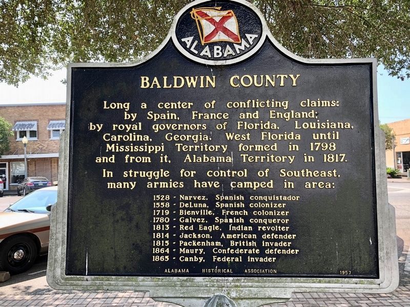
| 1 ► Alabama, Baldwin County, Bay Minette — A County Older Than the State, Baldwin County — |
| On Courthouse Square (U.S. 31) at Hand Avenue, on the left when traveling east on Courthouse Square. | |||
| 2 ► Alabama, Baldwin County, Fort Morgan — The Pride of Seven Flags — |
| On Dixie Graves Parkway near Alabama Route 180 W. | |||
| 3 ► Alabama, Baldwin County, Stockton — Bartram’s Trail — |
| On Alabama Route 59 at milepost 56, on the right when traveling north. | |||
| 4 ► Alabama, Baldwin County, Stockton — Major Robert Farmar Plantation — |
| On Alabama Route 225 just north of Lower Bryants Landing Road, on the left when traveling north. | |||
| 5 ► Alabama, Butler County, Greenville — Bartram's Trail — |
| On Sherling Lake Road (County Road 44) 1 mile west of Braggs Road (State Route 263), on the right when traveling west. | |||
| 6 ► Alabama, Chambers County, LaFayette — Muscogee Indians — |
| On South LaFayette Street (U.S. 431) at East Alabama Avenue, on the right when traveling north on South LaFayette Street. | |||
| 7 ► Alabama, Chambers County, Lanett — 141-10 — Ocfuskooche Tallauhassee — |
| On State Line Road (County Route 212) 0.1 miles south of North State Line Road, on the right when traveling north. | |||
| 8 ► Alabama, Clarke County, Barlow Bend — French's Chapel — |
| On Barlow Bend Road, 0.2 miles north of Madison Road (Route 33), on the left when traveling north. | |||
| 9 ► Alabama, Clarke County, Rockville — Bartram's Trail — |
| On Rockville Road (County Road 15) at Stimpson Sanctuary Road, on the right when traveling south on Rockville Road. | |||
| 10 ► Alabama, Cleburne County, Muscadine — Hernando de Soto in Alabama — |
| Near Interstate 20 (Interstate 20) west of Alabama Route 37, on the right when traveling west. | |||
| 11 ► Alabama, Conecuh County, Midway — Old Federal Road — |
| On County Road 1 at State Route 83, on the right when traveling south on County Road 1. | |||
| 12 ► Alabama, Dallas County, Selma — British West Florida, 1764-83 |
| On Citizens Parkway (Alabama Route 22) 0.2 miles north of Singleton Drive, on the right when traveling north. Reported missing. | |||
| 13 ► Alabama, Dallas County, Selma — Ecor Bienville — 1702-1743 — The first recorded name of Selma — |
| On Water Avenue at Lauderdale Street, on the left when traveling west on Water Avenue. | |||
| 14 ► Alabama, DeKalb County, Sulphur Springs — The De Soto Trail — Hernando De Soto In Alabama — |
| Near Interstate 59, 1 mile north of County Road 140, on the right when traveling south. | |||
| 15 ► Alabama, DeKalb County, Sulphur Springs — The De Soto Trail — |
| Near Interstate 59, 1 mile north of County Road 140, on the right when traveling south. | |||
| 16 ► Alabama, Elmore County, Wetumpka — Bartram's Trail — |
| On West Fort Toulouse Road, 0.1 miles west of U.S. 231, on the right when traveling west. | |||
| 17 ► Alabama, Elmore County, Wetumpka — William Bartram Arboretum — 1739 - 1823 — |
| Near West Fort Toulouse Road, 0.2 miles south of Jackson Park Road. | |||
| 18 ► Alabama, Etowah County, Rainbow City — Old Harmony Cemetery — |
| On Rainbow Drive (U.S. 411) east of Peteet Street, on the right when traveling east. | |||
| 19 ► Alabama, Greene County, Eutaw — A County Older Than The State, Greene County — |
| On Tuscaloosa Street (U.S. 11) east of Springfield Avenue, on the right when traveling east. | |||
| 20 ► Alabama, Henry County, Shorterville — Franklin - First Beachhead into East Alabama — |
| On Hartford Road (Alabama Route 10) 0.6 miles east of County Road 46, on the left when traveling east. | |||
| 21 ► Alabama, Jefferson County, Hoover — Hale - Joseph Home — Built in 1910 — |
| On Bluff Road at Cloudland Drive, on the right when traveling east on Bluff Road. | |||
| 22 ► Alabama, Lawrence County, Oakville — Cherokee Council House Museum — |
| 23 ► Alabama, Lee County, Smiths Station — Line 32° 28´ North Latitude — |
| On County Road 430, 0.6 miles south of County Road 248, on the left when traveling south. | |||
| 24 ► Alabama, Limestone County, Mooresville — Historic Homes of Mooresville — |
| Near Lauderdale Street west of East Street (County Road 71), on the right when traveling west. | |||
| 25 ► Alabama, Macon County, Tuskegee — Bartram's Trail — |
| On Forest Road 949, 0.2 miles north of State Route 186, on the left when traveling north. | |||
| 26 ► Alabama, Marengo County, Demopolis — St. Leo’s Catholic Church — |
| On South Main Avenue at West Perry Street, on the right when traveling north on South Main Avenue. | |||
| 27 ► Alabama, Mobile County, Creola — Site of Old Mobile — |
| On U.S. 43, 0.2 miles north of Richie Road, on the right when traveling north. | |||
| 28 ► Alabama, Mobile County, Le Moyne — Ellicott's Stone — Erected April 9th, 1799 |
| On U.S. 43 at milepost 19,, 0.1 miles south of Lofton Road, on the right when traveling north. Reported damaged. | |||
| 29 ► Alabama, Mobile County, Mobile — Cadillac Homesite — |
| On Conti Street, 0.1 miles west of South Royal Street, on the right when traveling west. | |||
| 30 ► Alabama, Mobile County, Mobile — Crown & Scepter of Isabel — |
| Near Government Street (U.S. 90) just east of South Hamilton Street, on the right when traveling east. | |||
| 31 ► Alabama, Mobile County, Mobile — Hernando de Soto — C 1500-1542 — |
| Near South Franklin Street south of Government Street (U.S. 90), on the left when traveling north. | |||
| 32 ► Alabama, Mobile County, Mobile — How Big was the Original Fort Condé? — |
| On South Royal Street at Church Street, on the right when traveling south on South Royal Street. | |||
| 33 ► Alabama, Mobile County, Mobile — Isabel La Catolica — 1451-1504 — |
| Near Government Street (U.S. 90) just east of South Hamilton Street, on the right when traveling east. | |||
| 34 ► Alabama, Mobile County, Mobile — Le Marquis de Lafayette visited Mobile — |
| On Government Street (U.S. 98) at South Jackson Street, on the right when traveling east on Government Street. | |||
| 35 ► Alabama, Mobile County, Mobile — Old Church Street Cemetery - 1819 — ←—« — |
| On Government Street (U.S. 90) at South Scott Street, on the right when traveling east on Government Street. | |||
| 36 ► Alabama, Mobile County, Mobile — Our Spanish Heritage — |
| On Government Street (U.S. 90) east of South Hamilton Street, on the right when traveling east. | |||
| 37 ► Alabama, Mobile County, Mobile — Pierre Le Moyne d'Iberville — |
| On St Francis Street at North Conception Street, on the right when traveling east on St Francis Street. | |||
| 38 ► Alabama, Mobile County, Mobile — Second Fort Conde Ruin — |
| On Church Street west of South Royal Street, on the right when traveling west. | |||
| 39 ► Alabama, Mobile County, Mobile — The Revolutionary War at Mobile — Siege of Fort Charlotte (Condé) 1780 — |
| On South Royal Street at Theatre Street, on the right when traveling south on South Royal Street. | |||
| 40 ► Alabama, Mobile County, Mobile — The Site of Historic Fort Condé — |
| Near South Royal Street just south of Church Street, on the right when traveling south. | |||
| 41 ► Alabama, Monroe County, Perdue Hill — Piache — |
| On U.S. 84 at Old Fort Claiborne Road, on the right when traveling west on U.S. 84. | |||
| 42 ► Alabama, Montgomery County, Montgomery — Encanchata — |
| On Water Street at Commerce Street, on the right when traveling east on Water Street. | |||
| 43 ► Alabama, Montgomery County, Montgomery — Struggle For Colonial Empire — |
| Near Water Streer at Commerce Street, on the right when traveling west. | |||
| 44 ► Alabama, Russell County, Fort Mitchell — Bartram's Trail — |
| On Alabama Route 165 north of Creek Trail, on the right when traveling north. | |||
| 45 ► Alabama, Russell County, Phenix City — Coweta: Center for International Diplomacy — Creek Heritage Trail — |
| Near Dillingham Street at Brickyard Road (Route 61). | |||
| 46 ► Alabama, Russell County, Phenix City — William Bartram Trail — Traced 1773-1777 — Deep South Region |
| On U.S. 280 just east of General Colin Powell Parkway, in the median. Reported missing. | |||
| 47 ► Alabama, Shelby County, Montevallo — The Colonial Courthouse / The Stocks and Pillory — |
| Near Montevallo Road (Alabama Route 119) 0.3 miles south of Alex Mill Road, on the right when traveling south. | |||
| 48 ► Alabama, Shelby County, Montevallo — The Liberty Bell — |
| Near Montevallo Road (Alabama Route 119) 0.3 miles south of Alex Mill Road, on the right when traveling south. | |||
| 49 ► Alabama, Shelby County, Montevallo — The Liberty Bell Garden — Honors Liberty, Its Defenders, and Our Constitution — |
| Near Montevallo Road (Alabama Route 119) 0.3 miles south of Alex Mill Road, on the right when traveling south. | |||
| 50 ► Alabama, Shelby County, Montevallo — The Lucille Ryals Thompson Colonial Chapel / One Nation Under God — |
| Near Montevallo Road (Alabama Route 119) 0.3 miles south of Alex Mill Road, on the right when traveling south. | |||
| 51 ► Alabama, Shelby County, Montevallo — The President's Oval Office / The Glorious Burden — |
| Near Montevallo Road (Alabama Route 119) 0.3 miles south of Alex Mill Road, on the right when traveling south. | |||
| 52 ► Alabama, Shelby County, Montevallo — Washington Hall / Birth of A Nation — |
| Near Montevallo Road (Alabama Route 119) 0.3 miles south of Alex Mill Road, on the right when traveling south. | |||
| 53 ► Alabama, Sumter County, York — Line 32° 28´ North Latitude — |
| On 4th Avenue (U.S. 11) 0.6 miles north of Longshore Drive, on the right when traveling north. | |||
| 54 ► Alabama, Talladega County, Lincoln — Lincoln, Alabama — |
| On County Road 433 north of 1st Avenue, on the right when traveling north. | |||
| 55 ► Alabama, Tallapoosa County, Jacksons' Gap — Fort Okfuskee — ←— 6 mi. west —« — |
| On U.S. Highway 280, on the right when traveling north. | |||
| 56 ► Arizona, Apache County, Chinle — The Place Where Two Fell Off — |
| Near Mummy Cave Overlook Road, 1.5 miles east of North Rim Highway (Indian Route 64). | |||
| 57 ► Arizona, Maricopa County, Phoenix, Central City — Eusebio Francisco Kino — |
| On 17th Street. | |||
| 58 ► Arizona, Pima County, Tucson, Downtown — Garcés Footbridge — Puente de Garcés — Historic Site — |
| 59 ► Arizona, Pima County, Tucson, West University — Eusebio Francisco Kino, S. J. — 1645-1711 — |
| On East 2nd Street, on the right when traveling west. | |||
| 60 ► Arizona, Santa Cruz County, Nogales — Mission Guevavi — |
| Near North River Road, 2.2 miles west of East Patagonia Highway (State Highway 82). | |||
| 61 ► Arizona, Santa Cruz County, Tubac — Juan Bautista de Anza — 1734 - 1788 — |
| On Burruel Street, on the right when traveling north. | |||
| 62 ► Arizona, Yuma County, Yuma — "Indian Hill" — |
| Near Prison Hill Road, 0.5 miles north of Harold C. Giss Parkway. | |||
| 63 ► Arizona, Yuma County, Yuma — Juan Bautista de Anza National Historic Trail — |
| Near Prison Hill Road, 0.5 miles north of Harold C. Giss Parkway. | |||
| 64 ► Arizona, Yuma County, Yuma — The All-important Colorado River Crossing — Juan Bautista de Anza National Historic Trail — |
| Near Prison Hill Road, 0.5 miles north of Harold C. Giss Parkway. | |||
| 65 ► Arkansas, Arkansas County, Arkansas Post — The European Settlement — |
| Near Old Post Road south of State Route 169. | |||
| 66 ► Arkansas, Arkansas County, Arkansas Post — The Post under Spain — |
| Near Old Post Road, 0.7 miles south of State Route 169. | |||
| 67 ► Arkansas, Crittenden County, Marion — Father Jacques Marquette and Louis Joliet's French expedition arrived in Arkansas — |
| Near Cypress Drive. | |||
| 68 ► Arkansas, Miller County, Fouke — Brief Moments in Fouke History — From the Native Americans… — |
| On East Main (County Road 9) just west of Snell Street, on the right when traveling west. | |||
| 69 ► Arkansas, Monroe County, Holly Grove — Louisiana Territory: 1682-1800 — Louisiana Purchase Historic State Park — |
| Near State Highway 362, 1.8 miles east of U.S. 49. | |||
| 70 ► Arkansas, Monroe County, Holly Grove — The Purchase: 1801-1803 — Louisiana Purchase Historic State Park — |
| Near State Highway 362, 1.8 miles east of U.S. 49. | |||
| 71 ► Arkansas, Saline County, Benton — De Soto Trail — |
| On E. Carpenter Street (State Highway 35) at Military Road, on the right when traveling east on E. Carpenter Street. | |||
| 72 ► California, Alameda County, San Leandro, Farrelly Pond District — De Anza Expedition 1775 - 1776 — |
| Near East 14th Street (State Highway 185) near Toler Avenue. | |||
| 73 ► California, Butte County, Oroville — Liberty Pole — |
| Near Bird Street at Huntoon Street. | |||
| 74 ► California, Contra Costa County, Rodeo — The De Anza Expedition in Rodeo — |
| On Parker Avenue south of 4th Street, on the right when traveling north. | |||
| 75 ► California, Kern County, Mettler — 291 — Fages-Zalvidea Trails — California Historical Landmark — |
| On Maricopa Highway (Highway 166), on the right when traveling west. | |||
| 76 ► California, Lake County, Upper Lake — Upper Lake Through Time |
| Near Main Street south of First Street. Reported permanently removed. | |||
| 77 ► California, Los Angeles County, Gardena — The Washington Elm — Gardena Civic Center — |
| On 162nd Street at Harvard Boulevard, on the right when traveling east on 162nd Street. | |||
| 78 ► California, Los Angeles County, Long Beach — Bay of Smokes — 1986, by Patrick Mohr — |
| Near Donald Douglas Drive, 0.1 miles west of Barbara London Drive, on the right when traveling south. | |||
| 79 ► California, Los Angeles County, Los Angeles, Chinatown — 5 — Zanja Madre — “Mother Ditch and the History Slugs” — Los Angeles State Historic Park — |
| On Spring Street at Sotello Street, on the left when traveling north on Spring Street. | |||
| 80 ► California, Los Angeles County, Los Angeles, Downtown Los Angeles — Avila Adobe — circa 1818 — El Pueblo de Los Angeles — |
| On Olvera Street south of Cesar E. Chavez Avenue, on the right when traveling north. | |||
| 81 ► California, Los Angeles County, Los Angeles, Downtown Los Angeles — Camero — Los Pobladores — The Founders of the City of Los Angeles — |
| On Paseo de la Plaza at Olvera Street on Paseo de la Plaza. | |||
| 82 ► California, Los Angeles County, Los Angeles, Downtown Los Angeles — Christine Sterling — |
| Near Paseo de la Plaza at Olvera Street. | |||
| 83 ► California, Los Angeles County, Los Angeles, Downtown Los Angeles — El Camino Real — |
| On North Main Street at Paseo Luis Olivares, on the left when traveling north on North Main Street. | |||
| 84 ► California, Los Angeles County, Los Angeles, Downtown Los Angeles — Felipe de Neve, 1728–84 — Spanish Governor of the Californias, 1775–82 — |
| Near Main Street north of U.S. 101, on the right when traveling north. | |||
| 85 ► California, Los Angeles County, Los Angeles, Downtown Los Angeles — Lara — Los Pobladores — The Founders of the City of Los Angeles — |
| On Paseo de la Plaza at Olvera Street on Paseo de la Plaza. | |||
| 86 ► California, Los Angeles County, Los Angeles, Downtown Los Angeles — Mesa — Los Pobladores — The Founders of the City of Los Angeles — |
| On Los Angeles Street at Paseo de la Plaza on Los Angeles Street. | |||
| 87 ► California, Los Angeles County, Los Angeles, Downtown Los Angeles — Moreno — Los Pobladores — The Founders of the City of Los Angeles — |
| On Los Angeles Street at Paseo de la Plaza on Los Angeles Street. | |||
| 88 ► California, Los Angeles County, Los Angeles, Downtown Los Angeles — 159 — Pico House — 1869-70 — El Pueblo de Los Angeles — |
| On El Pueblo de Los Angeles Plaza at North Main Street, on the right on El Pueblo de Los Angeles Plaza. | |||
| 89 ► California, Los Angeles County, Los Angeles, Downtown Los Angeles — Quintero — Los Pobladores — The Founders of the City of Los Angeles — |
| On Los Angeles Street at Paseo de la Plaza on Los Angeles Street. | |||
| 90 ► California, Los Angeles County, Los Angeles, Downtown Los Angeles — Rodríguez — Los Pobladores — The Founders of the City of Los Angeles — |
| On Los Angeles Street at Paseo de la Plaza on Los Angeles Street. | |||
| 91 ► California, Los Angeles County, Los Angeles, Downtown Los Angeles — Rosas — Los Pobladores — The Founders of the City of Los Angeles — |
| On Pueblo de Los Angeles Plaza at Sanchez St on Pueblo de Los Angeles Plaza. | |||
| 92 ► California, Los Angeles County, Los Angeles, Downtown Los Angeles — Rosas — Los Pobladores — The Founders of the City of Los Angeles — |
| On Pueblo de Los Angeles Plaza at Sanchez St on Pueblo de Los Angeles Plaza. | |||
| 93 ► California, Los Angeles County, Los Angeles, Downtown Los Angeles — Spanish Expeditions Into Southern California — Los Pobladores — The Founders of the City of Los Angeles — |
| On North Main Street north of Arcadia Street. | |||
| 94 ► California, Los Angeles County, Los Angeles, Downtown Los Angeles — The Founders of El Pueblo de Los Angeles — Los Pobladores — The Founders of the City of Los Angeles — |
| On Paseo de la Plaza at Olvera Street on Paseo de la Plaza. | |||
| 95 ► California, Los Angeles County, Los Angeles, Downtown Los Angeles — The Original Pueblo of Los Angeles — Los Pobladores — The Founders of the City of Los Angeles — |
| On North Main Street at Paseo Luis Olivares and Paseo de la Plaza on North Main Street. | |||
| 96 ► California, Los Angeles County, Los Angeles, Downtown Los Angeles — Vanegas — Los Pobladores — The Founders of the City of Los Angeles — |
| On North Main Street at El Pueblo de Los Angeles Plaza on North Main Street. | |||
| 97 ► California, Los Angeles County, Los Angeles, Downtown Los Angeles — Villavicencio — Los Pobladores — The Founders of the City of Los Angeles — |
| On North Main Street north of Arcadia Street. | |||
| 98 ► California, Los Angeles County, Los Angeles, Downtown Los Angeles — Yangna — Los Pobladores — The Founders of the City of Los Angeles — |
| On North Main Street north of Arcadia Street. | |||
| 99 ► California, Los Angeles County, Los Angeles, Downtown Los Angeles — Zanja Madre — |
| Near Olvera Street south of Cesar E Chavez Avenue, on the left when traveling south. | |||
| 100 ► California, Los Angeles County, Los Angeles, Hollywood Hills — Old North Church — |
| On Memory Lane just east of Memorial Drive, on the left when traveling east. | |||
11442 entries matched your criteria. The first 100 are listed above. Next 100 ⊳