Where Rivers and People Come Together
You are standing on ground that has been a gathering place for rivers, people and legends for thousands of years. Nearby is the confluence, or meeting, of two mighty rivers—the Mississippi and . . . — — Map (db m185834) HM
Giacomo Constantino Beltrami
1779 – 1855
Italian jurist, scholar and explorer, on July 7, 1823, started his journey into the wilderness of northern Minnesota resulting in his discovery of the source of the Mississippi River August 19, 1823. . . . — — Map (db m231720) HM
The Mississippi is one of the world's great river systems and the longest river in North America, flowing over 2300 miles from its source at Lake Itasca to discharge into the Gulf of Mexico. Here at Edgewater Park, less than 500 miles from its . . . — — Map (db m238317) HM
Did you know that Lake of the Isles and Lake Calhoun are married?
Yes, it's true! When dredging was finished on the canal and lagoon between the lakes, they were "married" in a symbolic ceremony on July 5, 1911. The day was named . . . — — Map (db m237060) HM
Missionaries Samuel and Gideon Pond arrived at Fort Snelling in 1834 and were immediately dispatched to work with Cloudman, Chief of the Dakota people, who had established an agricultural settlement on the eastern shores of Lake Calhoun near the . . . — — Map (db m212037) HM
Did you know that Shingle Creek was the water source for the first swimming pool at Webber Park?
Shingle Creek was once the site of a popular swimming hole. In 1908, however, the land was acquired for the park, and the creek dammed. . . . — — Map (db m231755) HM
Standing near here at the river's edge 5000 years ago, you would have felt the spray and heard the thunder of a spectacular waterfall. If you returned once every 500 years you would have seen the waterfall carving the Mississippi River's only true . . . — — Map (db m163305) HM
Mill Ruins Park embraces the flour-milling district that once lined the west bank of the Mississippi River at the heart of Minneapolis. Between 1858 and 1930, the milling district developed along the waterpower canal built here by the . . . — — Map (db m240366) HM
Pioneer Period
1821–23
Waterpower development at the Falls of St. Anthony began with construction of a gristmill and sawmill near the foot of 7th Avenue South by soldiers from Fort Snelling. The mill provided flour and lumber for the . . . — — Map (db m237363) HM
The Falls of St. Anthony are the only significant cataract on the Mississippi. Their natural beauty captured the imagination and attention of Native Americans as well as early explorers and settlers. In the summer of 1680, Father Louis Hennepin, . . . — — Map (db m243168) HM
This 1893 map shows the system of tunnels that ran under the West Side Milling District–part of the complex waterworks that brought energy from the 50-foot drop of the falls into the mills. Water from the
river above the falls flowed through . . . — — Map (db m28081) HM
The landscape around the Falls was transformed by many types of construction. Blasting and excavations for bridge supports and rail trackage modified the river banks, rail trestles were built over the canal and tailrace to serve the mills, and a . . . — — Map (db m241354) HM
When Europeans first saw the falls, the crest was well below Hennepin Island. Natural erosion caused the line of the falls to move steadily upriver at about four feet a year. By the 1850s, the cataract was approaching the upper limit of the . . . — — Map (db m28025) HM
Discriminatory rates charged by Chicago-owned railroads favored Milwaukee and Chicago flour mills. Minneapolis millers fought back by building their own railroad, the Soo Line.
On May 2, 1878, a massive explosion caused by flour dust . . . — — Map (db m243044) HM
The City Waterworks
Even during the heyday of the milling period, the towering mills, rail lines, bridges, and other aboveground features were only part of the setting which made the district an industrial powerhouse. Hidden underground . . . — — Map (db m235430) HM
Waterpower Engineering
Almost immediately after lands on the west side of the Falls were opened for private development in 1855, the Minneapolis Mill Company began to exploit the use of waterpower for commercial purposes. In 1857, the . . . — — Map (db m235926) HM
1. The Falls of St. Anthony
This cataract, in which the Mississippi drops about seventy-five feet, is formed by the jutting edge of a hard layer of limestone over a bed of soft sandstone. In pre-historic times, the falls was located near the . . . — — Map (db m231723) HM
The hydroelectric plant built at the end of the dam in the 1890s had large arched windows for light and ventilation. The dam today is downstream from the railroad truss bridge that towered above the plant; only piers from the bridge . . . — — Map (db m238618) HM
Minneapolis on the west bank of the river quickly overtook St. Anthony on the east side. A major reason was more efficient use of water power. In 1857 the Minneapolis Mill Company started to build a canal along South First Street. Enlarged and . . . — — Map (db m27746) HM
How did water turn the wheels of industry?
Without the direct drive waterpower from St. Anthony Falls, the Minneapolis riverfront we know today might not exist. From the 1850s into the 1900s, the strength of the Mississippi River allowed . . . — — Map (db m231591) HM
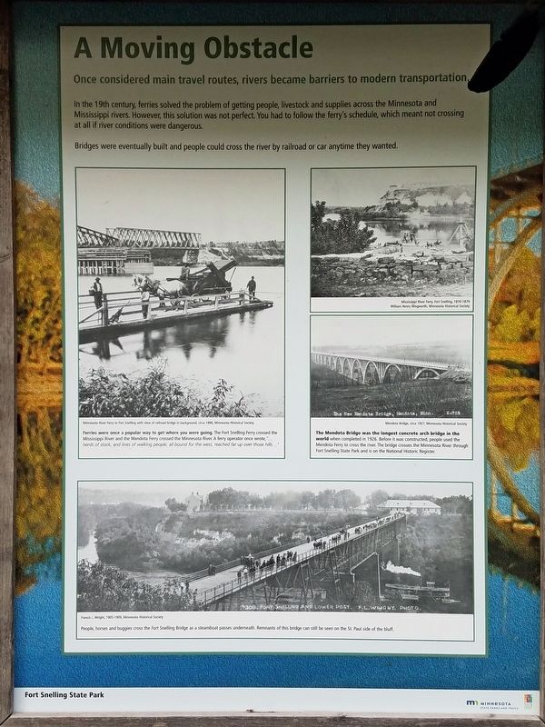
People have long crossed the river at about this point. This was a natural fording place, used by Native Americans and also by soldiers from Fort Snelling. The first documented ferry service was provided by a Dakota Indian woman with her canoe in . . . — — Map (db m50228) HM
This aerial view shows the gatehouse, water power canal and adjacent mills as they appeared in 1945. They, together with similar structures on the east bank, made Minneapolis the milling capital of the nation from 1880-1930. Changes in marketing and . . . — — Map (db m27169) HM
For Native American people, the Falls of St. Anthony was a landmark and sacred place. The river was a major highway for trade and travel. Although no Indian villages have been recorded here, oral traditions suggest frequent visits for fishing and . . . — — Map (db m43661) HM
After the Washburn A Mill explosion in 1878, a young Vienna-born engineer called on owner Cadwallader C. Washburn with a dust-collecting device that he said would prevent such accidents. Washburn hired him to oversee rebuilding the A Mill. . . . — — Map (db m43664) HM
Big Water
The Mississippi River, paramount among North American rivers, along with its tributaries, forms the world's fifth largest drainage system in area – 1,244,000 square miles. The Indians called this river "Father of Waters", . . . — — Map (db m106852) HM
Built in 1850, this was the first house on the west bank of the Mississippi, located at Saint Anthony Falls near the present-day Minneapolis Post Office.
John H. Stevens received permission to occupy the site, a part of the Fort . . . — — Map (db m17264) HM
During the 19th century, settlers, tourists, and artists were drawn to the Falls picturesque beauty, while entrepreneurs seized the water power of the falls for their lumber and flour mills. Meanwhile, promoters of river transportation viewed St. . . . — — Map (db m212195) HM
Navigation on this stretch of the river in its natural state upstream from St. Paul to Minneapolis was hazardous. During high flows, the current was swift, and during low flows, huge boulders made navigation almost impossible. It wasn't until . . . — — Map (db m131135) HM
Those piles of stone and brush in the river, known as wing dams, are both cursed and praised by many a recreation boater. Lurking beneath the water near propeller depth, thousands of these jetties are located along the mainstem of the river. They . . . — — Map (db m131136) HM
The heavy cruiser USS MINNEAPOLIS was the second US Navy ship to bear the name. She was built at the Philadelphia Navy Yard, and commissioned 19 May 1934. MINNEAPOLIS was at sea off Pearl Harbor when Japan attacked on 7 December 1941. . . . — — Map (db m91372) HM
The battleship USS MINNESOTA was the second US Navy to bear the name. She was built at Newport News, VA, and commissioned 9 March 1907. MINNESOTA sailed in late 1907 as a member of the 16 ship "Great White Fleet" on a round-the-world . . . — — Map (db m91371) HM
Here You Are Here, by the only natural waterfalls on the Mississippi River, the town of St. Anthony Falls got its start in the 1850s. The falls, considered sacred by the Native Americans who once called this area home, powered the mills that . . . — — Map (db m238160) HM
Rolling along the River
The Mississippi River was an important trade route. Dakota, Ojibwe, and other American Indian people had moved along the river in canoes for thousands of years. Settlers began to arrive on steamboats into St. Paul . . . — — Map (db m235665) HM
"This section of the Grand Rounds is of outstanding importance to the city, but more particularly so to the East Side... A very interesting feature of this drive is the wonderful view it affords of the network of railroads and shops . . . — — Map (db m245371) HM
Midstream in the Mississippi River, Nicollet Island served countless generations of Indian people as a crossing point and camping spot. After Europeans assumed the right to make boundaries, the island lay between lands claimed by England, France, . . . — — Map (db m155492) HM
Because of the rapid growth of population, agriculture, and industry in the Upper Midwest after 1900, Congress authorized the Corps of Engineers to construct the Mississippi River locks and dams. The Mississippi River, once the principal artery of . . . — — Map (db m232537) HM
A Dakota word for "falling waters"
described Saint Anthony Falls, an untamed cascade extending form shore to shore until the mid-1800s. Major Thomas Forsyth visited the falls in 1819:
In this 1928 photograph, men work on the horseshoe dam that extends from the trash sluice on which you stand. Hennepin History Museum
The first major attempt to tame the river was a rare collaboration . . . — — Map (db m240532) HM
The Saint Anthony Falls Water Power Company (SAFWPC) and the Minneapolis Mill Company (MMC) were chartered by the territorial legislature in 1856, two years before Minnesota achieved statehood. The companies were on the frontier of America—and . . . — — Map (db m235347) HM
"Colonel Farquhar said to me that, in his opinion, only eternal vigilance would keep the falls in existence..."—William de la BarreWater poured through the collapsed tunnel in 1869, undermining foundations of some . . . — — Map (db m230028) HM
"The astounding fact about Minneapolis in 198 is that men live there today who can remember when Minneapolis was not. Sixty years ago there was no Territory of Minnesota. These are matters for marvel as one sees this vast expanse . . . — — Map (db m243714) HM
This was the site from which Father Louis Hennepin, the Franciscan Priest, first viewed the Falls of St. Anthony in June of 1680. He named the falls after his patron saint St. Anthony of Padua.
The famous waterfall was responsible for the birth . . . — — Map (db m225467) HM
1882
Tunnel finished; 2 Victor turbines power the Pillsbury A Mill. Low water levels soon raise concerns about the reliability of waterpower
1884
Steam engine installed to supplement waterpower—a move towards less . . . — — Map (db m243558) HM
1882
Tunnel finished; 2 Victor turbines power the Pillsbury A Mill. Low water levels soon raise concerns about the reliability of waterpower
1884
Steam engine installed to supplement waterpower—a move towards less . . . — — Map (db m243531) HM
Lumbering was the first major industry at Saint Anthony Falls.Detail from Map of Minneapolis, Minnesota, 1885 Minneapolis Public Library Special Collections
In 1847, scouts . . . — — Map (db m241803) HM
–William de la Barre, Report upon the Projected Addition to the Water Power at the Saint Anthony Falls at Minneapolis, Minnesota, 1894
The river . . . — — Map (db m239759) HM
Minneapolis boasted the nation's first central hydroelectric station.The mast carrying the arc lights towers above downtown on the company's letterhead.
As sawmills adopted steam power by the 1880s and . . . — — Map (db m238433) HM
The Falls of St. Anthony is the only true waterfall on the 2,350-mile length of the Mississippi. It has eroded upriver many miles in the 12,000 years since humans first saw it. The falls then may have been as much as two miles wide and 200 feet . . . — — Map (db m238159) HM
During the nineteenth century, mills at the falls were driven directly by waterpower. Sawmills were often on platforms built out over the river, where water drove machinery through systems of shafts, gears, and belts. In the flour mills, water was . . . — — Map (db m155494) HM
In 1860, Silas Farnham bought a sawmill on Hennepin Island that had been built four years earlier, and soon J.A. Lovejoy became his business partner. The long pond leading to their mill was a prominent landmark. Its west wall formed part of the . . . — — Map (db m235753) HM
Long before farmers plowed Minnesota's western prairies, lumberjacks were felling pines in its northern forests. Beginning in the late 1840s, trees from Ojibway lands upriver were being cut into boards by sawmills at the Falls of St. Anthony. But . . . — — Map (db m155493) HM
Built in 1848, the Ard Godfrey House is the earliest frame house still standing in Minneapolis. An example of Greek Revival architecture, it originally occupied a site in the vicinity of Main and Second Streets Southeast.
Ard Godfrey, a . . . — — Map (db m37774) HM
Geology
The river flows over land, once a seabed, laid down 500 million years ago. The top layer, covered by soil left much later by glaciers, is hard Platteville limestone, which is up to 35 feet thick beneath much of . . . — — Map (db m243666) HM
Here at the Falls of St. Anthony, where waterpower, river transportation, and eventually railroads came together, the industrial heart of the upper Midwest began to beat in the mid-1800s. Keen-eyed factory and mill owners from the states of the . . . — — Map (db m155495) HM
In 1879 St. Paul railroad magnate James J. Hill opened his "Manitoba line" to the Canadian border, linking the wheat fields of the Red River Valley with the flour mills of Minneapolis. To improve railroad access at the falls he built this 2,100-foot . . . — — Map (db m21031) HM
Do you know how many bandshells have been built at Lake Harriet?
Five, each built with a distinct style and features.
1888: The first bandshell was constructed by the Minneapolis Street Railway Company on their property near the rail . . . — — Map (db m211907) HM
From time immemorial, Indians, Traders and Explorers
among whom were Hennepin and Carver have used the
Mississippi river as a highway of travel, unloading
their canoes at the bend just below here. They
plodded up the portage trail across what is . . . — — Map (db m140044) HM
Wedged between the Mississippi River and the steep river bluffs, the isolated but legendary district known as Bohemian Flats flourished for nearly 70 years.
English scholar George Tuthill Barrett traveled through Minneapolis in the early . . . — — Map (db m232014) HM
In May, 1822, a Fort Snelling drummer boy named Joseph R. Brown and his friend, William Snelling, son of the fort's commander, canoed up what is now called Minnehaha Creek to "discover" a lake long sacred to the Indian people who built burial mounds . . . — — Map (db m59258) HM
Named for Charles W. Christmas, first county surveyor of Hennepin County, elected in 1852, who platted the original town site of Minneapolis for John H. Stevens and Franklin Steele. This lake and Lake Minnetonka now occupy what in pre-glacial times . . . — — Map (db m71571) HM
These two grindstones from the Rice Flour Mill became historical finds from the October 1982 flooding when the Fish Hook River rose 5 inches. The Rice Brothers (Franklin and Gilbert) came to Park Rapids in about 1880 and one year later located a . . . — — Map (db m206371) HM
The Corps of Engineers dates back to the Revolutionary War. On June 16, 1775, the day before the Battle of Bunker Hill, the Continental Congress appointed a Chief Engineer and two assistants for the Grand Army; a few years later, in 1779, Congress . . . — — Map (db m189200) HM
Drainage of surface water is vital to all aspects of development, from town sites to agricultural crop land. Its importance, impact, and consequences cannot be over stated. With the western expansion of the United States, swamp lands. as they . . . — — Map (db m166441) HM
When Daniel Delaney and a man named McLeod camped on the shores of the lake in 1855, they became the first white men of record to visit the area. John Masters, a land developer who came in 1856, gave the body of water its name.
Diamond has . . . — — Map (db m76925) HM
Wakanda is a spiritual place or "where the spirit dwells" in Dakota. The Dakota people named this area before the settlers came to Kandiyohi County. Prior to 1900 there was evidence of this being a place of burial grounds. Over time, erosion and . . . — — Map (db m231706) HM
1938 A thorough study of a hundred acre location was carried out by the U.S. Commission of Surveys. Dam and mill site were purchased for $14,000. Land for fish ponds extended a mile downstream. Citizens contributed $1,300, and some easements . . . — — Map (db m79642) HM
1858 A natural waterfall was discovered by pioneer Larson while on a hunting and trapping expedition three miles upriver from Nest Lake.
1859 Larson established a camp near the falls but had to abandon it when his tent and most of his . . . — — Map (db m79590) HM
Green Lake has had three names. The Dakota who spent their summers here for hundreds of years, called it Mdeto.
The first whites called it Carnelian, for its red sandy beaches. Later settlers observed the green color, as the Indians had, and . . . — — Map (db m77792) HM
Several families settled near Green Lake's Crow River inlet in 1864. This became a trading center known as Green Lake Village, with a post office established in 1867. That same year the Green Lake lumber and grist mills were built. Lumber milling . . . — — Map (db m231754) HM
Solomon and Adaline (Stocking) Foot, with their four children, were the first settlers in Willmar Township, at this site in 1857. (Nearby Foot Lake was named after them.) Ground was broken in the spring. Vegetables, grain, and corn were planted. At . . . — — Map (db m231806) HM
Turning Back Time
The wetland before you is only a small part of the Weber Waterfowl Production Area; this original 80 acre site was bought from Regina and Anthony Weber in 1965. Additional land was purchased between 1970-74. This 421 acre . . . — — Map (db m77714) HM
From the late 1600s to about 1820 the chain of waterways of which Minnesota's border lakes form a segment was the thoroughfare of a vast fur trading empire. As its longest, this water route stretched from Montreal to Lake Athabasca, and over it a . . . — — Map (db m8363) HM
Steamboats on the Rainy River
As a part of the fabled “Voyageurs’ Highway” of rivers and lakes, Rainy Lake and the Rainy River saw a traffic of fur trade canoes for nearly two centuries before the first steamer, the Louise Thompson, . . . — — Map (db m206948) HM
Pellet Island claims its third victim
Fierce winds and forceful waves prove undoing for modern, powerful vessel.
Thanksgiving Day, 1979 started out like any other day for Captain Clyde Trueax and his crew aboard the 600-foot bulk . . . — — Map (db m203366) HM
Sound When Sight Fails
When bad weather obscured a lighthouse beacon, navigators relied on its fog signal. Swirling snow and pea-soup fog could even make Split Rock Lighthouse invisible during the day. Navigators aboard ore boats relied on . . . — — Map (db m203737) HM
Diver Discovery
The cold, clear waters of Lake Superior have preserved the remains of many important shipwrecks. In 1961, two divers located the wreck of the bulk freight steamer Hesper along the western breakwaters of the harbor. . . . — — Map (db m203364) HM
The three houses you see here were built in 1909, and housed the lighthouse keeper, his assistants, and their families in 1910. The keepers lived in these homes until the shipping season ended in December, then wintered in other homes until the . . . — — Map (db m203745) HM
Photos courtesy of the Great Lakes Shipwreck Preservation Society
Hesper
May 5, 1905
The Hesper was lost when it was caught in a late spring snow storm in 1905. The storm's 60-mile-an-hour winds drove it well off its . . . — — Map (db m203554) HM
This lighthouse was built after a 1905 storm damaged 29 boats and resulted in more than three million dollars in damages.
Split Rock Lighthouse stands as a beacon to safety in the lake shipping industry. Construction began in 1909, with a . . . — — Map (db m203739) HM
This concrete platform is all that's left of the building that housed the steam hoist engine used to build Split Rock Lighthouse.
Everything needed for building the light station in 1909-10 arrived by boat. The hoist engine powered a winch . . . — — Map (db m204161) HM
It's the early morning hours of November 28, 1905.
Imagine yourself standing right here in the middle of one of the worst storms in Great Lakes history: 65-mile-per-hour winds, blinding snow, and 30-foot waves crashing into the cliff. . . . — — Map (db m204163) HM
Why Safe Harbors?
Minnesota contains 150 miles of Lake Superior shoreline. With few exceptions, the shore is rocky and inhospitable to boaters in an emergency. From the time of American Indians and French-Canadian Voyagers paddling their . . . — — Map (db m203370) HM
This anchor was salvaged from the shipwreck of the 5000-ton steel barge, Madeira, which was tossed up against Gold Rock Point, about a quarter mile northeast of here, during the fierce storm of November 27-28, 1905. As the ship broke . . . — — Map (db m78751) HM
This concrete platform is all that remains of the building that housed the steam hoist engine that was used in constructing Split Rock Lighthouse.
Everything needed for building the light station in 1909-10 came by boat. The hoist engine . . . — — Map (db m78717) HM
It's the early morning hours of November 28, 1905.
Imagine yourself standing right here in the middle of one of the worst storms in Great Lakes history—65-mile-per-hour winds, blinding snow, 30-foot waves crashing into the cliff.
The . . . — — Map (db m78716) HM
This hinge pin and truss segment came from the original Gooseberry River Bridge (No. 3585). The original one-lane bridge was constructed in 1925 and widened in 1937 to include a second lane and sidewalks. The bridge was replaced in 1996 by the . . . — — Map (db m204509) HM
In commemoration of the
50th anniversary of the first shipment
of iron ore from the State of Minnesota,
through the port of Two Harbors
and
to the memory of those men
of vision and courage,
who promoted the
Duluth & Iron Range . . . — — Map (db m78823) HM
With the onset of WWII the nations demand for steel created the need for bigger ships. It was evident that the original harbor breakwater was too small to accommodate the newer ships that were often 600+ feet long.
The original breakwater. . . . — — Map (db m204331) HM
The "railroad tracks" on the shore before you are the last vestiges of a once vibrant commercial fishing village in Agate Bay. It was an easy transition for Scandinavian immigrants to begin fishing almost immediately upon arrival in America. The . . . — — Map (db m78851) HM
Shortly after the first shipment of iron ore left Agate Bay, the U.S. Government developed a plan to improve the safety of the harbor. In 1887 construction began on the West breakwater. Also, one acre of land was purchased on which to build a light . . . — — Map (db m204339) HM
The Land is Rising... and Shaping the Shore
About 10,000 years ago, glacial ice covered the North Shore and caused the earth to sag. When the ice melted, a great weight was removed and the land began to rise or "uplift." Uplift, along with . . . — — Map (db m204396) HM
This boat the Crusader II was built in 1939 by Ruben and Charles Hill of Larsmont Minnesota. It was christened by Crown Prince Olav of Norway during a visit to Knife River.
The Hill family built over 200 boats used mostly by the commercial . . . — — Map (db m78820) HM
Built in 1896 by the Cleveland Ship Building Company, the Edna G. was the last steam driven tugboat in operation on the Great Lakes when it was retired in 1981. She is currently owned by the City of Two Harbors.
Named after the daughter, . . . — — Map (db m204341) HM
This 10-ton bronze propeller from the Eugene W. Pargny shown with tug Edna G, leaving its home port, Two Harbors. Built 1917, the 600-ft. boat made 37 trips yearly until retired 1984. Gift of D. James Jumer, 1999 — — Map (db m204333) HM
Take a Walk: Discover a Legacy
Wander through the park and see the skills used by the CCC boys to create these structures. Marvel at the detailed stonework of the Castle. Then, walk across the bridge to see the Falls View Shelter.
Boys . . . — — Map (db m204397) HM
Having Fun on the North Shore
In the late 1800s, the North Shore was becoming a popular recreational destination. Guidebooks from 1872 promoted the "recreational splendors of Lake Superior." By 1895, the North Shore recreation industry was . . . — — Map (db m204433) HM
As you walk the pebbled beaches of the North Shore, watch for translucent, color-banded, and reddish-brown stones called Lake Superior agate—Minnesota's state gemstone. The story of the Lake Superior agate begins 1.1 billion years ago, when basaltic . . . — — Map (db m204248) HM
It looks out upon the waters of Lake Superior, the largest fresh water lake in the world, known by the Chippewas as Kitchi Gummi. From this point the lake extends easterly 400 miles and westerly 30 miles. Raddison and Grosseillers canoed this lake . . . — — Map (db m180428) HM
The large steel structures protruding into Agate Bay are massive iron ore docks. They replaced the earlier and smaller wooden docks built between 1883 and 1896. Of the three steel docks only Dock 1 and Dock 2 are in service today. Dock 1 the closest . . . — — Map (db m204323) HM
312 entries matched your criteria. Entries 101 through 200 are listed above. ⊲ Previous 100 — Next 100 ⊳