On University Street, 0.1 kilometers south of Jubilee Avenue West, in the median.
[English] "Great Rush of men to the Porcupine!" "On to the Porcupine is now the Cry!" Prospectors and speculators came from across the continent to take part in the Porcupine Gold Rush that began in earnest in 1909 with the . . . — — Map (db m244343) HM
On Airport Road, 5.8 kilometers north of Laforest Road, on the right.
[English] Once the ore is mined from the earth, the gold must be removed from the ore. The extraction of gold from ore and refining it into 'pure' gold involves a number of physical and chemical processes that are carried out on an . . . — — Map (db m244417) HM
On McIntyre Road just north of Schumacher Drive (Provincial Highway 101), on the left when traveling north.
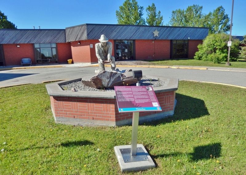
Erected by the Timmins-Porcupine Chamber of Commerce in June, 1966 to commemorate development of this important zinc, copper, lead, silver discovery (time capsule in base) ————— Celebrating 50 Years of World Class Mining and Metallurgy (2016) Kidd . . . — — Map (db m244446) HM
On Trans-Canada Highway (Provincial Highway 11) at Hanna Road, on the right when traveling north on Trans-Canada Highway.
At this point the 49th parallel of latitude north of the equator crosses the highway. This line forms the southern boundary of the western provinces of Manitoba, Saskatchewan, Alberta and most of British Columbia. In 1818 a treaty between Great . . . — — Map (db m217889) HM
On Zina Street at Louisa Street, on the right when traveling west on Zina Street.
Construction of this imposing brick court house was begun in the spring of 1880. Designed by C.J. Soule, a Guelph architect, it was built by the contracting firm of Dobbie and Grierson. Although the first provisional county council meeting was held . . . — — Map (db m196159) HM
On Randall Drive at Kingston Road West (Durham Regional Highway 2), on the left when traveling north on Randall Drive.
The parish of St. George’s Anglican Church was founded at Duffins Creek (now known as Pickering Village) in 1832. The first incumbent of the parish, the Reverend Adam Elliot, originally met with his parishioners at their homes in an area that . . . — — Map (db m243739) HM
On Old Kingston Road just west of Church Street North, on the left when traveling west.
Between 1801 and 1807 a settlement developed here in Pickering Township where the Danforth Road crossed Duffin's Creek. Among the early settlers was Timothy Rogers, a prominent Quaker and colonizer who built a saw and grist-mill in 1809. A . . . — — Map (db m208413) HM
On Old Kingston Road just west of Church Street North, on the left when traveling west.
From this site, the rich vibrant tone of this bell could be heard throughout the village. For over fifty years, beginning in 1890, the village bell announced the outbreak of fire. When the First Pickering Company of volunteer firemen was formed . . . — — Map (db m208430) HM
This building was constructed by pioneers who emigrated to this area from Pennsylvania in the early 1800's. Members of the congregation hauled the bricks from the Cherrywood brick-yard. Heads of local families served through the years as trustees. . . . — — Map (db m194577) HM
On McRae Street at Trootie Street, on the left when traveling east on McRae Street.
(west side)Sacred to the Memory of Maj. Robert E. Wallace Pte. Horace O. Kift Pte. James J. Halward Lieut. William K. Kift Sapr. Roy C. Woodward Pte. Howard F. Mackin Pte. John H. Dawe They passed out of the sight of men by the path of duty . . . — — Map (db m147899) WM
Near Peace Street just north of McRae Street, on the right when traveling north.
Robert Holmes spent a lifetime drawing and painting Canadian wildflowers, depicting many varieties in water-colours. Holmes was born in Cannington and is buried here. After studying at the Ontario School of Art and the Royal College of Art, his . . . — — Map (db m147898) HM
On King Avenue East, 0.1 kilometers Beaver Street North, on the left when traveling east.
One of Canada's leading publishers, Joseph Atkinson was born here in Clarke Township and, at eighteen, began his journalistic career with the Port Hope Times. He subsequently moved to Toronto where he was employed first with the World and later the . . . — — Map (db m244766) HM
On King Street East at Division Street, on the left when traveling west on King Street East.
Originally known as Darlington Mills, Bowmanville was founded in 1794 when an American family of Loyalists settled near the site of Vanstone's Mill. The first businesses were established in the river valley south of the mill but are now gone. . . . — — Map (db m245101) HM
On Mill Street South at Boulton Street, on the right when traveling south on Mill Street South.
The first European settlers in Clarke Township were the Lovekins and the Bates arriving within weeks, possibly days, of one another.
Richard Lovekin Sr. arrived from County Cork, Ireland, via the United States and Niagara-on-the-Lake early in . . . — — Map (db m244742) HM
On Temperance Street at Church Street, on the right when traveling south on Temperance Street.
When war was declared by Great Britain in 1914, recruitment of Canadian troops soon followed. This mural depicts the ceremony as the town's first volunteers marched off with great pride to board the trains for Halifax. The 136th Battalion spent the . . . — — Map (db m245080) HM WM
On Wellington Street at Silver Street, on the right when traveling west on Wellington Street.
Central Public School was not the initial building to occupy this site. The first building was a two story frame structure built about 1840 as Bowmanville's first court house and town hall.
In 1855, as an improvement to education, an assortment . . . — — Map (db m245076) HM
On Wellington Street at Silver Street, on the right when traveling west on Wellington Street.
Central Public School
Tower Bell
Established 1889 restored on this site
in recognition of the outstanding
educational contributions by
Tom Turner
Principal 1954-1983
June 28. 1983 — — Map (db m244817) HM
On Church Street at Temperance Street, on the right when traveling east on Church Street.
Prior to moving to Church Street, Bowmanville's first fire hall
stood in the location of our present Town Hall. With no horse team of their own, a $10.00 reward was offered to the owner of the first team of horses to arrive at the hall during a . . . — — Map (db m245133) HM
On Temperance Street at Church Street, on the right when traveling south on Temperance Street.
This structure is the third to be used as a town hall in Bowmanville's history. The
first was on the site of Central Public School (NW corner of Elgin and Wellington). It was a large wooden building that also served as a court house and school. . . . — — Map (db m245078) HM
On Temperance Street at King Street West, on the right when traveling south on Temperance Street.
An ardent Canadian and founder of the Canadian Club movement, McCullough was born in Bowmanville and moved to Hamilton in 1888. He and four companions in December, 1892, determined to found an organization which would encourage the study of Canada's . . . — — Map (db m245082) HM
On Temperance Street at King Street West, on the right when traveling north on Temperance Street.
With Mr. Levi Tole conducting auction sales & hawkers of patent medicines pitching their wares, the Church & Temperance St. or Market Square, was a busy centre of downtown activity. On the edge of the square was the town pump. This was a popular . . . — — Map (db m245097) HM
On Church Street, 0.1 kilometers west of Temperance Street, on the right when traveling west.
This once prestigious property, the 'Rathskamory Estate' was the residence of Dr. George Lowe. With its well groomed gardens surrounded by stately beech, maple & elm trees, this beautiful ten acre property lay between Lowe & Concession Streets. Also . . . — — Map (db m245208) HM
On Temperance Street at Church Street, on the right when traveling north on Temperance Street.
Both St. Andrew & St. Paul's Churches derive their roots from the same early Presbyterian congregation which began holding formal services in 1843. The first St. Andrew's Church, a small frame building, was opened here in 1842 on a parcel of land . . . — — Map (db m245123) HM
On Courtice Road at Bloor Street, on the right when traveling north on Courtice Road.
Perhaps the most fervent of the Methodist sects, the Bible Christian Church was formed in southwestern England in 1815 and established in Upper Canada during the 1830s.
Served by itinerant preachers, its small but loyal memberShip . . . — — Map (db m245216) HM
On Old Kingston Road, 0.2 kilometers east of Durham Highway 2, on the right when traveling east.
This cairn marks the site of a late 19th century grist mill and miller’s house. The stones are from the foundation of the miller’s house.
In 1874 Jacob Stalter built a mill pond, just north of this site, close to the junction of the Black & . . . — — Map (db m245538) HM
On Old Kirby School Road at Ganaraska Road, on the left when traveling north on Old Kirby School Road.
A distinguished authority on tropical diseases, Stanton was born near here and educated at Trinity Medical College, Toronto. In 1907, after serving as house surgeon at the Hospital for Tropical Diseases in London, England, he accepted a . . . — — Map (db m244768) HM
On Mill Street South at Edward Street West, on the right when traveling south on Mill Street South.
An outstanding humanitarian and churchman, Brent was born near Newcastle and ordained in Toronto in 1887. Following parochial service in Buffalo and Boston, he was elected first Episcopal Bishop of the Philippine Islands in 1901. Confronted by the . . . — — Map (db m244750) HM
On Durham Regional Highway 2, 0.2 kilometers east of Cobbledick Road, on the right when traveling west.
On this site in 1866 Samuel Wilmot began to experiment with the artificial breeding of salmon. His success led the federal government in 1868 to enlarge Wilmot’s project into Ontario's first full scale fish hatchery, one of the earliest in North . . . — — Map (db m244767) HM
On King Avenue East at Beaver Street South on King Avenue East.
The Masseys at Newcastle
One of the world's largest manufacturers of heavy farm machinery, Massey-Ferguson has its foundations in a modest family business developed in Newcastle. Established in Bond Head by Daniel Massey, the . . . — — Map (db m244762) HM
On Concession Road 7, 0.5 kilometers west of Liberty Street North, on the right when traveling west.
Robert McLaughlin, a pioneer of the Canadian vehicle industry, was born in the family homestead on this property. In 1867, despite lack of technical training, he built two cutters in his driving-shed which stood near this site. His business . . . — — Map (db m244813) HM
On Durham Regional Road 13 at Concession Road 7 (County Road 1), on the right when traveling west on Durham Regional Road 13.
Established in 1869 as a home site, it was then used as a hotel from 1879 to 1897. Albert Cook expanded the building and opened the general store in 1898. Herb Harrison was the proprietor from 1919 to 1949. The store was, and still is, . . . — — Map (db m243793) HM
On Durham Regional Road 1 (Concession Road 7) just north of Leaskdale Road, on the right when traveling north.
[English] From 1911 to 1926, this Presbyterian manse was home to Lucy Maud Montgomery, the world-famous author whose writing career was launched in Prince Edward Island. Here at Leaskdale she began her role as a wife and mother, and . . . — — Map (db m199578) HM
On Durham Regional Road 1 just north of Leaskdale Road, on the right when traveling north.
In this house the author of “Anne of Green Gables” lived for fifteen years, and here wrote eleven of her twenty-two novels, including “Anne of the Island” (1915) and “Anne’s House of Dreams” (1916). Born in 1874 at Clifton, Prince Edward Island, . . . — — Map (db m199500) HM
Near Simcoe Street North (Durham Regional Road 2) just south of Parkwood Court, on the right when traveling south.
[English] A rare surviving example of the grand estates of the inter-war years, Parkwood consists of a richly decorated house set in 12 acres of grounds. The house, originally constructed in 1916-1917 to the designs of the Toronto . . . — — Map (db m208899) HM
Near Simcoe Street North (Durham Regional Road 2) just south of Parkwood Court, on the right when traveling south.
Born in nearby Enniskillen, McLaughlin apprenticed in his father's Oshawa carriage works when he was sixteen. Convinced of the potential for growth of the automobile industry, he established in 1907 the McLaughlin Motor Car Company, the first major . . . — — Map (db m198928) HM
Near Simcoe Street North (Durham Regional Road 2) just south of Parkwood Court, on the right when traveling south.
[English] A famous industrialist and philanthropist, “Colonel Sam” McLaughlin was a founder of the automotive industry in Canada. Involved in the design and manufacture of carriages and sleighs for his family business, he foresaw . . . — — Map (db m208898) HM
On Athol Street East just east of Celina Street, on the left when traveling east.
The Borsberry Music Hall was located on the north side of King Street, just east of Simcoe Street, a century ago. The Music Hall had a 700 seat capacity and played host to a number of dramatic and musical productions. The street scene outside the . . . — — Map (db m227851) HM
On Centre Street South (Provincial Highway 2A) just north of John Street West, on the left when traveling south.
[west side]They shall not grow old as we that are left grow old Age shall not weary them nor the years condemn At the going down of the Sun and in the morning we will remember them "This monument presented to the City of . . . — — Map (db m227777) WM
Near Centre Street South (Provincial Highway 2A) just south of King Street West, on the right when traveling south.
[English] In honour of our partnership and for the important role our community has played in Canada’s history, CN donated this commemorative tree in celebration of Canada’s 150th anniversary. Special thanks to the Government of . . . — — Map (db m244309) HM
On Celina Street south of King Street East, on the right when traveling south.
The evolution of Oshawa’s automobile industry is depicted in this mural. In 1899, the McLaughlin Carriage Factory was destroyed by fire, but rebuilt within one year. The McLaughlin Motor Car Company, founded in 1907, began producing automobiles an . . . — — Map (db m227889) HM
On Simcoe Street South (Provincial Highway 2) 0.06 kilometers north of Athol Street West, on the left when traveling north.
This mural, by local students of O’Neill C.V.I. and Msgr. Paul Dwyer C.H.S., depicts the first stage coach line that operated on Kingston Road (Hwy 2) between Fort Frontenac (Kingston) and Fort York (Toronto), 1817 to 1855. The last stop before . . . — — Map (db m227890) HM
Near Metcalfe Street just west of Simcoe Street South (Provincial Highway 2), on the left when traveling west.
[left panel]This building was made possible by the generous gift of Col. R. S. McLaughlin for the appreciation of music by the people of Oshawa ——— Dedicated in the year of our Lord 1942[right panel]And . . . — — Map (db m227899) HM
On Metcalfe Street just east of Center Street South (Provincial Highway 2A) when traveling east.
Memorial Park serves to honour the sacrifice that was made by the residents of Oshawa, men and women serving our country at war, and is home to two significant architectural features: the Cenotaph and the McLaughlin Bandshell. The Cenotaph, . . . — — Map (db m227900) HM
Near Simcoe Street South (Provincial Highway 2) just south of Metcalfe Street, on the left when traveling north.
This mural commemorates the 130 year history of Oshawa’s own Ontario Regiment and its involvement in the nation’s conflicts and UN peacekeeping. All of the medals depicted at the bottom of the mural are accurate representations of Canadian Military . . . — — Map (db m227868) HM
On Celina Street just north of Bruce Street, on the right when traveling south.
The Lake Ontario waterfront was a favourite gathering spot during the summer. Streetcars running north and south on Simcoe Street were a popular means of getting to the waterfront. Barnhardt’s Pavilion was famous throughout Oshawa and beyond for . . . — — Map (db m227800) HM
On John Street West just east of Centre Street South (Provincial Highway 2A), on the left when traveling east.
This stone marks the location of the chancel of St. George’s Church 1852-1924 ——— Erected by members of the Old Church April 23rd 1939. ——— Rectors Rev. J. Pentland, 1852 Canon J.R. Worrell, 1862 Canon W. Belt, 1869 Rev. H.B. Owen, 1875 . . . — — Map (db m227892) HM
On Centre Street South (Provincial Highway 2A) just south of King Street West, on the right when traveling south.
This bell hung in the steeple of the church that occupied this site from 1874 to 1967. The congregation was formed in 1831 in Darlington Township as the Christian Church under the leadership of Elder Thomas Henry and moved to a new building . . . — — Map (db m227947) HM
On Simcoe Street South, 0.2 kilometers Lakeview Park Avenue, on the right when traveling south.
"A very busy and thriving neighbourhood the harbour must have been in the middle decades of the last century when the Lake was the principal highway, when a great part of what was brought in came to the wharf, as well as most of what was sent . . . — — Map (db m245234) HM
Near Simcoe Street South, 0.2 kilometers south of Lakeview Park Avenue, on the right when traveling south.
"The house looked much the same as it does now. The buffalo house was behind Henry House and was used for a storage shed after the buffalo were taken away. "
- Betty MacInally
The land where Henry House stands was purchased by the Henry . . . — — Map (db m245223) HM
On Simcoe Street South, 0.2 kilometers Lakeview Park Avenue.
"It was more of a mystery to the kids of the area. For some reason on the main level of the house there was a pile of leather cuttings.
The kids used to dare one another to get pieces of leather to prove their entry into the house. You were . . . — — Map (db m245228) HM
On Simcoe Street South, 0.2 kilometers south of Lakeview Park Avenue, on the right when traveling south.
Ontario’s twelfth prime minister was born in Oshawa and educated at the University at Toronto and Osgoode Hall. A practising lawyer, he was a leader in civic affairs and in 1916-17 served as mayor of Oshawa. During the tollowing years he had various . . . — — Map (db m245225) HM
On Simcoe Street South, on the right when traveling south.
This Blue Spruce tree has been planted to commemorate the 200th anniversary of the arrival of Captain Benjamin Wilson and family from Vermont in 1790. The Wilsons settled just east of the current harbour location (Lot 4). Together with other early . . . — — Map (db m245256) HM
On Richmond Street West just west of Simcoe Street North (Provincial Highway 2), on the right when traveling west.
This montage presents images of Oshawa’s development including the historic Sydenham Harbour, and the Oshawa Carriage Works, the factory operated by the McLaughlin Carriage Company, forerunner of General Motors of Canada. Also depicted are a 1924 . . . — — Map (db m227891) HM
On Bond Street West just west of Prince Street, on the left when traveling west.
This mural was sponsored by General Motors of Canada. The first panel illustrates members of the McLaughlin family, founders of the McLaughlin Carriage Company and McLaughlin Motor Car Company, forerunner of General Motors of Canada. Other panels . . . — — Map (db m227775) HM
On Bond Street West, 0.08 kilometers west of Simcoe Street North (Provincial Highway 2), on the left when traveling west.
This mural portrays Oshawa’s development with the slogan “Building on a Strong Foundation.” Listed at the top are early companies from Oshawa’s past. The panels below depict scenes from three influential companies — Warren Mills, Williams Piano . . . — — Map (db m227773) HM
On Simcoe Street North (Durham Regional Road 2) at Richmond Street East, on the right when traveling north on Simcoe Street North (Durham Regional Road 2).
Capt. A. W. Hawkins • Capt. A. T. McNabb • Capt. A. F. Tongs • Lieut. S. C. Campbell • Lieut. C. S. Dickson • Lieut. W. S. Ecclestone • Lieut. O. H. Hopkins • Lieut. A. R. McCurdy • Lieut. H. Poupore • Lieut. C. E. Speers • S/Sgt. H. M. Paige • Sgt. . . . — — Map (db m244327) WM
On King Street East at Ontario Street, on the left when traveling east on King Street East.
The Argyle was a passenger and freight steamer that docked at Sydenham Harbour in the early 1900’s. It operated between Toronto and Cobourg with stops in Whitby, Oshawa and Bowmanville. The return fare from Oshawa to Toronto was $1.00. Evening . . . — — Map (db m227898) HM
Near King Street West at Prince Street, on the right when traveling east.
This mural depicts the four corners of downtown Oshawa as it was in 1935. Notice the manually operated traffic signal which was used at busy times of the day. Officer Ed Stauffer is directing traffic as he might have in the summer of 1935. — — Map (db m227799) HM
On King Street West just east of McMillan Drive, on the left when traveling east.
The Oshawa Generals Major Junior Hockey franchise was established for the 1937-38 season and immediately became a hockey powerhouse by winning seven consecutive Ontario championships through to 1944. The team has won five additional Ontario titles . . . — — Map (db m227776) HM
On Centre Street North (Provincial Highway 2A) just south of Bond Street West, on the left when traveling south.
Commissioned by the VON Durham Branch, this mural depicts the 100 year history to date of the VON in Canada. The VON was founded by Lady Ishbel Aberdeen, the wife of the Governor General, on the request of the National Council of Women as Canada’s . . . — — Map (db m227798) HM
On Boundary Road (Local Route 52) 0.7 kilometers south of Wentworth Street (Local Route 60), on the right when traveling south.
Upper Plaque On this site British Security Co-Ordination operated Special Training School No. 103 and Hydra. S.T.S. 103 trained allied agents in the techniques of secret warfare for the Special Operations Executive (SOE) Branch of the . . . — — Map (db m61880) HM
On Dundas Street West at Byron Street North, on the right when traveling west on Dundas Street West.
James Rutledge, chairman of the Board of Education, laid the corner stone for this building on June 9, 1913. The library was funded by the Carnegie Corporation in the United States, and was officially opened by the County Clerk John E. Farewell on . . . — — Map (db m217981) HM
On Byron Street North just south of Elm Street, on the left when traveling south.
A house on this site, demolished in 1971, was the childhood home of Georgina May Campbell. Under the stage name of May Irwin, she was America’s greatest vaudeville and stage comedienne from the 1880’s to the 1900’s. She is best known for an . . . — — Map (db m218005) HM
On Centre Street North at Dundas Street West, on the right when traveling south on Centre Street North.
On Nov. 2, 1872, the Merryweather steam fire engine shot a stream of water over the top of All Saints Church steeple through 800 feet of hose from a well at Brock and Dundas Streets. The test convinced the Town to purchase the engine. In 1969, . . . — — Map (db m236753) HM
On Reynolds Street at Gilbert Street East, on the left when traveling south on Reynolds Street.
Opened in 1874 by the Governor-General, Lord Dufferin, the Ontario Ladies’ College was established in "Trafalgar Castle", former residence of Nelson Gilbert Reynolds, Sheriff of Ontario County. Built in 1859, "Trafalgar Castle" was visited im 1869 . . . — — Map (db m245264) HM
On Brock Street North just north of Elm Street, on the right when traveling north.
In the Royal Hotel, Canada’s first Prime Minister, as Leader of the Opposition, delivered a speech on May 2, 1877 in support of the local Conservative candidate Thomas N. Gibbs of Oshawa. The Royal Hotel, operated by James Pringle, was built in . . . — — Map (db m218144) HM
On Byron Street North just south of Mary Street West, on the right when traveling south.
The Terrace, built as a fashionable address for professionals and their offices, is probably one of the finest examples of small-town Ontario row housing still standing in the province. The Whitby Local Architectural Conservation Advisory . . . — — Map (db m218147) HM
On Dundas Street West at Centre Street South, on the right when traveling west on Dundas Street West.
This church acknowledges being on the traditional territories of the Mississaugas of Scugog Island, the Iroquoian speaking Wendat and the 1923 Williams Treaties First Nations — — Map (db m236759) HM
On Dundas Street West at Euclid Street on Dundas Street West.
On July 10, 1847 at Scripture's Inn on this site, a public meeting
was called to change the name of Windsor to Whitby because
of confusion in mail and shipping, with Windsor near Detroit. Whitby village was first called Windsor in 1819 by John . . . — — Map (db m245277) HM
On Robinson Street just south of Pitt Street, on the right when traveling south.
The Port Burwell lighthouse was constructed in 1840. It was part of a national network of light stations equipped with beacon lights to warn or guide ships at sea. The Port Burwell light was used to aid navigation and commercial shipping of local . . . — — Map (db m198238) HM
On Talbot Street close to King Street, on the right when traveling west.
On September 15, 1885, the giant African elephant, star of the Barnum and Bailey Circus, met a untimely death when struck in St. Thomas by a Grand Trunk locomotive. To commemorate the one hundredth anniversary of this tragic event, the citizens of . . . — — Map (db m78342) HM
Near Talbot Street east of Horton Street, on the right when traveling east.
[English] The St. Thomas Canada Southern (CASO) Station, financed by American railway promoters, was constructed between 1871 and 1873 to serve as both the passenger station for St. Thomas and CASO's corporate headquarters. During the 1920s, . . . — — Map (db m198268) HM
[West Historic Marker]:Amherstburg Navy Yard
A Navy Yard was built here in 1796 to replace Detroit as the base and supply depot for the Provincial Marine on Lakes Erie and Huron. In 1812 the GENERAL HUNTER and QUEEN CHARLOTTE, built . . . — — Map (db m37552) HM
On Dalhousie Street, on the left when traveling south.
This house, one of the finest remaining examples of domestic Georgian architecture in Ontario, was commenced in 1816 and completed about 1819, by Robert Reynolds, the commissary to the garrison at Fort Malden. Bellevue was also the home of his . . . — — Map (db m103677) HM
Near Laird Avenue South just south of Elm Avenue, on the right when traveling south.
Boblo Island
For many centuries the island you see in front of you was used for hunting and fishing by First Nations people. Called Île aux Bois Blancs by the French, Boblo Island's key location made it a site for . . . — — Map (db m71185) HM
Near Laird Avenue South just south of Elm Avenue, on the right when traveling south.
Brick Officers' Guard Room
and Staff Sergeant's Quarters
(1839)
Poste de garde des officiers en
briques et quartiers du sergent
de l'etat-major (1839) — — Map (db m71220) HM
On Front Road South (County Route 20) south of Dalhousie Street, on the left when traveling south.
On January 9, 1838, a force of Canadians and Americans sympathizing with Mackenzie's rebellion, sailed from United States territory and landed on Bois Blane Island. The schooner "Anne," supporting the invasion, cruised along the Canadian mainland . . . — — Map (db m37246) HM
On Front Road South (County Route 20) close to Dalhousie Street, on the left when traveling south.
Near this site stood the house erected in 1784 by Matthew Elliott. Born in Ireland, he emigrated to the American Colonies in 1761, and during the Revolution served with the British forces as a captain in the Indian Department. He was an Indian agent . . . — — Map (db m37286) HM
Near Laird Avenue South just south of Elm Avenue, on the right when traveling south.
Connection to Town
Fort Malden (originally called Fort Amherstburg) was the anchor of the town, which grew to the south. In this view, you are looking past the parade grounds of the fort (now a park) down Dalhousie Street . . . — — Map (db m71192) HM
Near Laird Avenue South just south of Elm Avenue, on the right when traveling south.
Detroit River Heritage
This river not only forms the border between two great nations, but is also a vital transportation artery into the upper Great Lakes. Imagine the vessels that have travelled on it … First National canoes, . . . — — Map (db m71160) HM
On Laird Avenue South south of Elm Avenue, on the right when traveling south.
The post was begun by the Royal Canadian Volunteers in 1796 to replace Detroit and to maintain British influence among the western Indians. As the principal defense of the Detroit frontier in 1812, it was here that Isaac Brock gathered his forces . . . — — Map (db m34353) HM
Near Laird Avenue South just south of Elm Avenue, on the right when traveling south.
Fort Defences
In front of you is a recreated piece of the fort's palisade, a vertical wall of sharpened logs. This wall surrounded the fort, linking the four diamond-shaped corner projections, called bastions. Around each . . . — — Map (db m71173) HM
Near Laird Avenue South just south of Elm Avenue, on the right when traveling south.
Fort Malden Points of Interest • Fort Malden Points d'intérêt
(1) Visitor Centre
1939
Centre d'accueil
1939
(2) Military Pensioner's Cottage
circa 1851 (Restoration) . . . — — Map (db m71278) HM
Near Laird Avenue South just south of Elm Avenue, on the right when traveling south.
Indian Council House
Two hundred years ago a small building stood about 100 metres north of here, close to the water's edge. This was where meetings took place between the representatives of the British government and those of . . . — — Map (db m71170) HM
On Ramsay Street south of Gore Street, on the left when traveling south.
Born about 1750 in Fermanagh County, Ireland, Caldwell emigrated to Pennsylvania in 1773. During the American Revolution he served with the British forces as a captain in Butler's Rangers at Niagara and Detroit. In 1784 he obtained land near the . . . — — Map (db m37291) HM
Near Laird Avenue South close to Elm Avenue, on the right when traveling south.
Born at Queenston in Upper Canada, John Richardson served as a volunteer at Fort Malden during the War of 1812 and was taken prisoner by the Americans at Moraviantown. He was released at war's end, retired on half-pay in 1818, and spent most of the . . . — — Map (db m76737) HM
Near Laird Avenue South just south of Elm Avenue, on the right when traveling south.
Pensioner's Cottage
This cottage was built in the early 1850s for a retired soldier and his family. About 85 of these homes were constructed just east of the Fort, and leased at a modest rate to veteran soldiers in return for light . . . — — Map (db m71167) HM
Near Laird Avenue South just south of Elm Avenue, on the right when traveling south.
Privy
The foundations in front of you are from a communal privy (toilet) for enlisted men and their families that stood here in 1840. The women and children had a small room - the soldiers made do with an open structure offering . . . — — Map (db m71221) HM
Near Laird Avenue South just south of Elm Avenue, on the right when traveling south.
Shoreline Breakwall
Over time, the force of water and ice has eroded the river bank, creating the need to stabilize the shore. Parks Canada, the Essex Region Conservation Authority (ERCA) and Environment Canada partnered to . . . — — Map (db m71161) HM
On Front Street South (Provincial Highway 20) south of Bingham Road, on the left when traveling south.
Girty's life crossed cultural boundaries between native and white societies on the frontier of American settlement. In 1756 his family was captured by a French-led native war party in Pennsylvania. Simon was adopted by the Seneca, then repatriated . . . — — Map (db m34688) HM
On Front Street North (Provincial Highway 20) north of North Side Road, on the right when traveling south.
In the War of 1812, the first engagement in Canada involving British and American forces in significant numbers occurred here on the Canard River. On July 12, 1812, Brigadier-General William Hull invaded Canada and encamped near Sandwich. British . . . — — Map (db m34336) HM
Near Laird Avenue South just south of Elm Avenue, on the right when traveling south.
Strategic Location
A deepwater channel between here and Boblo Island brings ships close to shore, a fact dramatically illustrated when a north-bound lake freighter passes by. This was why Fort Amerstburg was originally located . . . — — Map (db m71191) HM
On Laird Avenue South south of Elm Avenue, on the right when traveling south.
Tradition has it that the Indian leader Tecumseh stood upon this stone to deliver a final address to the British at Amherstburg after the Battle of Lake Erie. Donated in 1939, it originally stood near the corner of Dalhousie and Gore Streets. In his . . . — — Map (db m34412) HM
In September 1813 the British squadron under R. Barclay sailed from Amherstburg to collect desperately needed food supplies. They were met by the larger, more heavily armed American squadron commanded by O. Perry. The British had the initial . . . — — Map (db m37707) HM
The office for the Commissariat Department was built in 1831 near the government wharf and storehouse. Commissary officials purchased from local contractors the flour, beef, straw and firewood used by troops. They also managed Fort Malden's . . . — — Map (db m37356) HM
On Dalhousie Street north of Richmond Street, on the right when traveling south.
Part of an ancient network of Indian paths, the Great Sauk Trail, as it came to be known, extended from Rock Island in present-day Illinois to the Detroit River. It played a significant role in the communications between the native peoples in the . . . — — Map (db m36976) HM
Near Laird Avenue South just south of Elm Avenue, on the right when traveling south.
The Site Over Time
Today the site looks very different than it would have 170 years ago, when Fort Malden was at its height. Almost all the buildings from that period have been lost, and most of the ditch and wall that encircled . . . — — Map (db m71174) HM
On Front Road North north of County Route 10, on the right when traveling south.
This area was once the home of the Wyandot, remnants of the Huron, Neutrals, and Petuns who were dispersed by the Iroquois in the 1640's. Some eventually reunited and settled along the Detroit River, where they became known as the Hurons of Detroit, . . . — — Map (db m37340) HM
Middle Island
Middle Island is the most southern piece of land in Canada. Only a few metres from the Canada-US border, the tiny 22-hectare island is part of the western Lake Erie archipelago. Migrating birds and insects use the island to . . . — — Map (db m124119) HM
2120 entries matched your criteria. Entries 201 through 300 are listed above. ⊲ Previous 100 — Next 100 ⊳