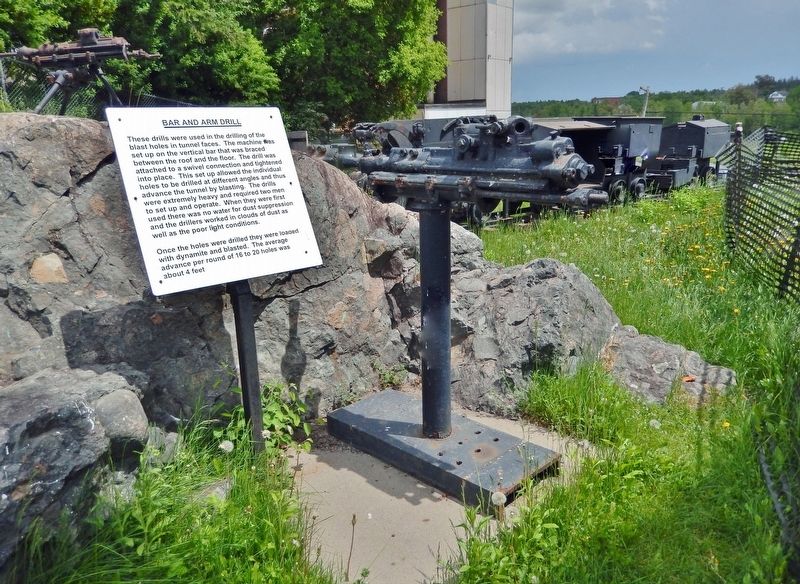
These drills were used in the drilling of the blast holes in tunnel faces. The machine was set up on the vertical bar that was braced between the roof and the floor. The drill was attached to a swivel connection and tightened into place. This set . . . — — Map (db m245397) HM
These small motors enabled trains of cars to be hauled to the dump points underground together instead of being pulled or pushed one at a time by a miner. The batteries were lead/acid and required charging up every day at underground charging . . . — — Map (db m245496) HM
This park is dedicated to the memory of Bruce Lonsdale for his outstanding contribution to the town of Cobalt and also to the citizens of the federal riding of Temiskaming. Bruce was born in Cobalt on November 10th 1949. His political career . . . — — Map (db m245497) HM
The cage was a major improvement from the bucket. There was protection from falling objects with the cage hood and the cage also ran between timber guides, which prevented the swinging around in the shaft that sometimes happened with the bucket, . . . — — Map (db m305471) HM
In front of you is what remains of Cart Lake. Silverfields Mining Corp. Ltd. from 1965 to 1983 operated a mill at the former Savage mine site a short distance SE of Cart Lake and disposed of their mill tailings into the lake, filling a good portion . . . — — Map (db m305596) HM
A time capsule was placed in this spot on August 06, 2006 to commemorate 100 years of incorporation for the Township of Coleman and the Town of Cobalt. To be opened August 6, 2056. — — Map (db m245396) HM
The Cobalt Lake Mining Company Limited was granted ownership of the mineral rights to 47 acres under the bed of Cobalt Lake in December, 1906. Access to the workings was gained from shafts around the south edge of the lake. Prospecting proved . . . — — Map (db m305076) HM
[English] Cobalt played a decisive role in the evolution of hard-rock mining in Canada. Between 1903 and the 1920s, the district’s rich veins triggered a mining boom which attracted international attention and led to Cobalt's . . . — — Map (db m208433) HM
About 900 yards southwest of here, on August 7, 1903, two lumbermen seeking timber for railroad ties made the initial discovery of the Cobalt silver camp. Named for its discoverers, the McKinley-Darragh mine operated from 1904 to 1927. In the rush . . . — — Map (db m219784) HM
The first Public School opened in the early spring of 1906 with 12 students. Since no trained teachers could be enticed from the south, one of the settlers — Elizabeth MacEwan, took responsibility for teaching the children. The school was built . . . — — Map (db m304799) HM
[English] This railway station was built in 1905 and expanded in 1906 and 1908. A final expansion was started in 1909 and completed in 1910. The silver mines were a magnet for thousands of people and tons of supplies most of which . . . — — Map (db m245704) HM
[English] Cobalt Street offers a good example of frontier style mining architecture. Most of the houses date back to the earliest days of the camp. Settling was easier in the area as people got off the train and headed past the . . . — — Map (db m245910) HM
Locally, silver and cobalt were found in vertical veins that often came to bedrock surface but were buried under overburden. In the early days, in order to find them, they either systematically dug through the overburden by hand, or used high . . . — — Map (db m305598) HM
[English] Until the Cobalt boom, very little attention was paid to mining stocks in eastern Canada. The Cobalt rush created a stock market frenzy. Speculators from New York, London and Chicago flocked into the camp. . . . — — Map (db m304978) HM
The Royal Canadian Legion, Branch 44 and the Town of Cobalt dedicate this park to honour the courage and bravery shown by Edward James Gibson Holland, who, on November 7, 1900 at Leliefontein, South Africa, kept the Boers at bay using his colt . . . — — Map (db m304800) HM WM
This type of loader replaced the miner’s shovel and greatly increased production underground. Use of these machines meant that larger mine cars could be used which in turn meant bigger tunnels, and more ore could be moved. Mucking machines are . . . — — Map (db m245399) HM
Ore from the Nipissing mines was sorted at a central picking plant into three grades for processing. The lowest grade ore, assaying under 100 oz per ton, was stored on dumps or sent to a Low Grade Mill to be concentrated by separating the silver . . . — — Map (db m305379) HM
The deep gash in this hillside is all that remains of silver vein No. 96. The vein was originally discovered in 1908 by the Nipissing Mining Company Limited using an exploration method called trenching. Trenches are simply shallow channels dug down . . . — — Map (db m44574) HM
The mineral rights for this location were originally owned by the Temiskaming and Northern Ontario Railway. Following the discovery of silver at the south end of Cobalt Lake in 1903, The Right of Way Mining Company Limited was formed for the . . . — — Map (db m305084) HM
These cars were generally too big for handtramming and were normally used in TRAINS pulled by BATTERY LOCOS. The cars were either loaded by a mucking machine or by a CHUTE and the car then trammed to the DUMP. The car body was pushed over sideways . . . — — Map (db m245494) HM
[English] Although most of the original Cobalt mines had closed by the 1920s, many were operated in the coming decades by small independent operators known as leasers. A second major mining boom began in the 1940s . . . — — Map (db m304905) HM
[English] Silver has been an important mineral product for Canada’s economy ever since the Cobalt boom which followed the discovery of rich veins of the metal near here in 1903. Although the production of the Cobalt silver mines began to . . . — — Map (db m208443) HM
The sinking bucket was initially used to mine the vertical openings or SHAFTS that were used to access the ore bodies at depth. The buckets were used to hoist the waste rock after it had been blasted and also to hoist the water from the shaft . . . — — Map (db m305486) HM
The SLUSHER hoist was used to move broken rock in the underground mining areas called STOPES. The ore was blasted and the scraper was pulled to move the ore so that more drilling could be done. In the early 1900's this would have been done with a . . . — — Map (db m305086) HM
[English] The idealists are flocking in by the trainload from every corner of the globe, for the fame of this wonderful Silver City has spread far. Some are old-time California placer miners of Arizona and Sonora. Not a few are from . . . — — Map (db m245801) HM
[English] When the Cobalt boom started, the Ontario Government was completely unprepared for the sudden influx of settlers. There was no plan for dealing with the needs of the rapidly growing community. Over 80% of the land within . . . — — Map (db m245394) HM
[English] The Coniagas #4 shaft is one of the more unique buildings in the north. The Coniagas Company sank the #4 shaft in 1914, even though it was right in the center of a very busy downtown. The shaft was sunk to a . . . — — Map (db m304796) HM
[English] The Glory Hole was an open pit operation that dropped over 250 feet below where you are standing. The thick wire cables you see used to form a spider web pattern across the opening to support a tin roof that kept the . . . — — Map (db m245395) HM
[English] The Hilltop affords a wonderful view of Cobalt. In the early days of the camp, the residents of the hilltop area tended to be merchants and professionals. Some of those living below referred to the Hilltop . . . — — Map (db m304798) HM
James McKinley and Ernest Darragh worked for the Temiskaming and Northern Ontario Railway. While collecting timber in August 1903, they found “glittering rock” on the south shore of Cobalt Lake 200 m northeast of this location. The rock . . . — — Map (db m304998) HM
The mine hoist was the connection between surface and underground and provided the power to raise and lower the conveyances in the shafts. In the very early days in Cobalt the hoist consisted of a hand powered windlass similar to the type of . . . — — Map (db m305112) HM
[English] This is the original site of the Nancy Helen Mine. After the mine closed, houses were built, including one that stood here at 56 Grandview. The original owner of the house was Eddie Hollands, former mayor, and winner of . . . — — Map (db m245840) HM
[English] In 1903, the Temiskaming and Northern Ontario Railway were working hard to complete the line between North Bay and the farming communities of New Liskeard and Haileybury. The Klondike Rush was over and many Bushmen were . . . — — Map (db m245481) HM
[English] The Silver Rush was on. Just imagine the most bustling town north of Toronto, the promise of riches attracting people from all over North America and other parts of the world. The Cobalt Nugget newspaper had subscribers . . . — — Map (db m245804) HM
[English]"As you enter the town great smoke stacks belching forth voluminous black clouds meet the eye, and the throbbing of engines, the heartbeats of Cobalt industry, come to the ear." —Silver City News The Townsite #1 . . . — — Map (db m245389) HM
Drilling and blasting on surface required a very heavy drill that wouldn’t move as it drilled. The answer was the Tripod Drill which was a drifter machine mounted on a very heavy frame. These machines were used to drill in the open cuts in some . . . — — Map (db m245398) HM
The elevated ridge on which you are standing represents the remains of a section of the old Nipissing Central Railway electric street car line. The original route extended between Cobalt and Haileybury and was first used by the public on April 30, . . . — — Map (db m304999) HM
The Little Silver vein was discovered in 1903 by a French Canadian lumberman named Tom Hebert. It was subsequently acquired by the Nipissing Mining Company Limited and was to become the first of many producing veins for the company. The actual vein . . . — — Map (db m305299) HM
To Cobalt he gave its name, and a place among the great mining camps of the world. He read the secret of the rocks, and opened the portal for the outpouring of their wonderful riches. His monument is New Ontario. — — Map (db m245400) HM
[English] Physician and poet, William Henry Drummond was born in Ireland in 1854, and came to Canada with his parents about ten years later. In 1884 he graduated in medicine from Bishop's College, Lennoxville, serving in rural . . . — — Map (db m208453) HM
[English] This all steel welded sculpture of the North American Bison stands 19ft (5.8m) high and 27ft (8.2m) long. It weighs 9 tons. Mike Camp, the sculptor, worked over a year on this unique work of art (1983-1984). Commissioned . . . — — Map (db m244986) HM
Noted and famed as a boxer, prospector, and civic leader, it was close to this
location that the intrepid John Alexander "Jack" Munroe, landed in
1906. Born in Boulardarie, Cape Breton, Nova Scotia on June 26, 1873
he arrived along with his . . . — — Map (db m285351) HM
[English] Englehart owes its beginnings to the Temiskaming and Northern Ontario Railway (T. & N.O.), a colonization line designed by the provincial government to open agricultural lands of the Little Clay Belt to settlement and to . . . — — Map (db m218102) HM
Built by Canadian Locomotive Company Kingston, Ontario May 1921 for the Temiskaming & Northern Ontario Rly. Type 4-6-2 (Pacific) locomotive for passenger service. Tractive Force (36,600 + 9,920 booster) • 46,520 lbs. Cylinders, diameter and . . . — — Map (db m244901) HM
The Temiskaming & Northern Ontario Railway (T&NO) was central to the settlement and economic growth of northeastern Ontario. Steam locomotives hauled passenger coaches filled with settlers and rail cars loaded with minerals, forest products and . . . — — Map (db m244900) HM
In affectionate memory of the men of Englehart who made the supreme sacrifice 1914 — 1918 Clark, R. • Flanagan, J. • Forrester, E. • Horsman, H. • Marsh, J. • Grant, J. • McLean, D. • Pardon, A. • Smith, S.E. • Tellier, F. • Watters, A. . . . — — Map (db m244962) WM
[English] In 1912 the Proclamation declaring Haileybury as the District Seat gave rise to such structures as the Court House, Land Registry Office and District Jail. The proclamation was largely due to the dreams and efforts of the founder of . . . — — Map (db m195932) HM
In 1904 when the Town of Haileybury was incorporated, our fire department was established.
On October 4, 1922, as a result of a horrendous forest fire, Haileybury was devastated and left in ruins. The Great Fire of 1922, considered one of the ten . . . — — Map (db m195959) HM
[English]
At the Haileybury Jail, a total of nine people have paid with their lives for the crimes they committed. The last hanging in the jail occurred on Tuesday, June 13, 1961, when Owen “Mickey” Feener, a husky Nova Scotian miner, fell . . . — — Map (db m195958) HM
Their name liveth
for evermore
Men of Haileybury who gave their lives
1914 – 1918
Carlton Green • Alex Cantley • Frank Cooke • Jack Fisher • Beverley Nesbitt • Monty Montgomery • Robert Hume • Rrnest Holland • Albert Fleming • Talbot . . . — — Map (db m195960) WM
[English] These small motors enabled trains of cars to be hauled to the dump points together instead of being pulled or pushed one at a time by a miner. The batteries were lead/acid and required charging up every day at underground . . . — — Map (db m244798) HM
[English] The cage is used to convey men and equipment up and down the shaft. It is also used to haul ore to surface for processing in the mill. Note the tracks in the floor which allowed ore cars to be rolled in and out of the . . . — — Map (db m244884) HM
The Public School in Kirkland Lake began with a meeting in October 1916 of local ratepayers. At that meeting the local School Board was authorized to borrow funds to erect and equip a school house. In 1924 a second school building was built to . . . — — Map (db m244797) HM
Boyles Brothers BBU-1 Underground Diamond Drill • Powered by compressed air – V twin motor • Easily disassembled for transport to confined underground locations • Capacity of 300 m using “A” size rods • Often drilled multiple holes from one . . . — — Map (db m244891) HM
[English] These small ore cars could be pushed by hand (hand tramming) or hauled by an electric locomotive along an underground railway system. The cars could be loaded by hand (shovel), by a mucking machine, or by opening a chute . . . — — Map (db m244895) HM
[English] Accidental fires were frequent in pioneer days. One of the first structures built at a mine site would be the water tower. Usually built on an elevated site, it would provide enough pressure to supply hoses connected to . . . — — Map (db m244896) HM
[English]This monument commemorates the prospectors of the Kirkland Lake Gold Camp, whose discoveries led to the incorporation of Kirkland Lake (Teck) in January 1919. Dedicated on June 29, 2019, in honour of the Kirkland Lake . . . — — Map (db m244878) HM
The Larder Lake gold rush of 1906 was accompanied by discoveries of gold at Swastika and, in 1911, the first strike at Kirkland Lake was made by William H. Wright. The Tough-Oakes became the camp's first producing gold mine in 1912. During the peak . . . — — Map (db m217887) HM
The very existence of Kirkland Lake is the result of a rich natural heritage which was developed by the hard work and sweat of the men who went underground to earn a living for themselves and their families. Faced with many hazardous working . . . — — Map (db m244800) HM
To commemorate the official opening of the Municipal Offices of the Corporation of the Town of Kirkland Lake June 26, 1980 by the Chief Administrative Officer D. B. McDougall Mayor G. L. Hamilton Councillors M. . . . — — Map (db m244796) HM
42,583,205 oz. of gold was produced up to 2012 in the Kirkland Lake Region. As of May 24 2014 the price per oz. of $1416.61 would represent 60.3 Billion in today's dollars. “And there is still more gold in the region” — — Map (db m244799) HM
[English] The mine hoist is a large winch that raises and lowers the two cages from surface to the underground workings. The hoist operator communicated with the underground stations at each level via signals such as: 1 Bell = . . . — — Map (db m244897) HM
[English] The sinking bucket was initially used to mine the vertical openings or SHAFTS that were used to access the ore bodies at depth. The buckets were used to hoist the waste rock after it had been blasted and to hoist the water . . . — — Map (db m244898) HM
[English] This winch could be powered by steam or compressed air. It is small enough to be hauled into place by a team of horses. To sink a small shaft, a large tripod would be set up over the hole and a sinking bucket be used to . . . — — Map (db m244899) HM
[English] Latchford began in 1903 as Montreal River Station, a town site and river crossing for the Temiskaming and Northern Ontario Railway, the colonization line designed to open the Little Clay Belt to settlement and provide . . . — — Map (db m208488) HM
Born in Latchford and raised near Porquis Junction, Cosens enlisted in the Argyll and Sutherland Highlanders of Canada, Canadian Active Service Force, 1940 and transferred to the Queen’s Own Rifles of Canada in 1944. Early on February 26, 1945, his . . . — — Map (db m208559) HM WM
For more than two decades, ending in the late 1980’s the Sherman Mine provided ore for the DOFASCO steel mill in Hamilton, and work for the people of Latchford and area. The sample is comprised of “iron formation” that in this case is composed of . . . — — Map (db m208521) HM
In 1925 the Ontario government began construction of this 260-mile trunk-road between Cochrane and North Bay. The road was intended to link the rapidly developing mining and agricultural communities of “New Ontario” with the province's southern . . . — — Map (db m208500) HM
[English] Prior to its present location, the local library had various residencies in the town. The building of the New Liskeard Library was facilitated by a grant of $10,000 from the Andrew Carnegie Library Foundation in 1910. The new . . . — — Map (db m195930) HM
The New Liskeard Public Library Building was erected in 1910 through the assistance of a grant from Andrew Carnegie. Local limestone was used in the construction and it remains a classic example of the Carnegie libraries. Much of the original . . . — — Map (db m195929) HM
Formed with “metallic inclusions”, this geologic anomaly was put on display at Teck-Hughes Gold Mine by manager George Gilchrist. In 1962 it was extracted from the 3400 foot level by Don Dekker & Al Murphy by way of the South Shaft and an interior . . . — — Map (db m304797) HM
[English] The First Chartered Air Mail Service and the Haileybury Wharf: The wharf at Haileybury was an active hub for planes, boats and people in the early days. The Laurentide Air Service Ltd. was the first to be . . . — — Map (db m304594) HM
At the beginning of the 20th Century, when wood was the main heating fuel, Quebec farmers regularly crossed the ice on Lake Temiskaming with sleigh loads of cord wood drawn by teams of horses. Their goal was to sell the wood to Haileybury . . . — — Map (db m304597) HM
The City of Temiskaming Shores honours the contribution of the 90 years of continuous charitable service by the women of the IODE Haileybury Chapter (1923-2013) Now part of the history of the area, the Chapter began in 1923 in answer to the needs of . . . — — Map (db m304598) HM
[English] Lake Temiskaming, a freshwater lake is shared by both Ontario and Quebec as it forms part of the provincial border between the two provinces. Created during the last ice age, as the glacier carved its way . . . — — Map (db m304595) HM
[English] The principal source of the world's white opals is from the South Australian outback where temperatures exceed 50 degrees Celsius. Miners insulate themselves by living and working beneath the surface. Much . . . — — Map (db m304599) HM
[English] Millionaires Row in Haileybury is characterized by stately homes situated along Lakeshore Road looking out on the lake. This section of Lakeshore Road came to be known as Millionaires Row in reference to the . . . — — Map (db m304592) HM
[English] Ottawa River A bird's-eye-view of the Ottawa Valley illustrates its most important natural feature the Ottawa River. One of the great rivers on the continent and the second largest in eastern . . . — — Map (db m304788) HM
[English] The Haileybury School of Mines began in 1912, offering part time classes, as part of the regular curriculum of the Haileybury High School. The school is currently under the direction of Northern College and . . . — — Map (db m304596) HM
[English] Settlement and Conflagration Charles Cobbold Farr, chief trader at the Hudson Bay Company's Fort Temiskaming, in 1883 purchased 30 acres of land known as Humphrey's Depot. Natives had originally named . . . — — Map (db m304795) HM
[English] The Sisters of Assumption, a congregation of French nuns, were devoted to the teaching of young girls and the Convent was one of the first educational institutions in this northern region. The building is . . . — — Map (db m304593) HM
One of the “Ten Worst Disasters in Canadian History” occurred on 4 October 1922. Within six hours ninety percent of the Town of Haileybury was destroyed by a raging bush-fire. Strong westerly winds had thrown burning embers onto the Town and then . . . — — Map (db m304724) HM
[English] The Inukshuk, symbol of the North, can be found throughout the Arctic. The Inukshuk represents a strong connection to the land and has many purposes. It may give direction to a traveler, mark a cache of . . . — — Map (db m304747) HM
[English] This sculpture, from a set of six, was originally mounted on the William H. Wright building in Toronto, home of the Globe and Mail Newspaper. In 1974 when the Wright building was demolished, the Globe and . . . — — Map (db m304781) HM
English: The Little Clay Belt, the rich agricultural belt extending north from New Liskeard, was originally inhabited by the Algonquin First Nations, including Joachim "Clear Sky" Wabigijic and Angela Lapointe who lived by the mouth . . . — — Map (db m199224) HM
[English] The Grand Union Hotel was built in 1905 by two Syrian immigrants, Mike Abraham and Dick Zahalan. The hotel was built 4 stories high, with 48 bedrooms, a high class parlour, its own electric plant and . . . — — Map (db m305133) HM
Historical Bits Suggested reading: A Boater's Guide To Historic Lake Temiskaming by Peter Fancy available at Haileybury Heritage Museum. Kipawa River Lodge On the north shore of the Kipawa river, at the falls is the Tim-Kip Lodge as it . . . — — Map (db m305203) HM
[English] The structure of the museum is modelled after the Shepherdson Wood and Basket Works which was originally located on Shepherdson Road. The LCHM represents the homesteaders who developed the area. It is . . . — — Map (db m305154) HM
[English] New Liskeard was, and still is, well known for its “Mile of Beach” that runs along the north shore of Lake Temiskaming. The Beach in the early days had a grand-stand, racetrack, dance pavilion, . . . — — Map (db m305174) HM
[English] Northern Farm Country As with many northern Ontario towns, the Town of New Liskeard was shaped by geography and geology. In the wake of the glaciation era, some 10,000 years ago, rich deposits of clay . . . — — Map (db m305295) HM
[English] Ottawa River A bird's-eye-view of the Ottawa Valley illustrates its most important natural feature the Ottawa River. One of the great rivers on the continent and the second largest in eastern Canada, . . . — — Map (db m305180) HM
[English] Staking a Claim The Town of New Liskeard is situated at the mouth of the Wabi River where it flows into Lake Temiskaming, a location long known as a haven from storms. This was once the seasonal . . . — — Map (db m305256) HM
[top tablet]In honored memory of the men of New Liskeard and vicinity who gave their lives in the Great War 1914-1918S. Alberta • R. Arnold • E. Arnold • B. Armstrong • L. Bass • G. H. Ball . . . — — Map (db m305296) WM
On October 4, 1922, scattered bush fires which had been burning for some days north of Haileybury were united by strong winds into a holocaust which spread over most of 18 townships and took an estimated 43 lives. Burning out of control between the . . . — — Map (db m199980) HM
The height of land known as the Artic Watershed crosses Highway 11 at this point.North of here, water drains into Hudson Bay; rivers, lakes and streams to the south flow into the Great Lakes. As the northern wilderness came under development, the . . . — — Map (db m195924) HM
[English] The height of land known as the Artic Watershed crosses Highway 11 at this point. North of here, water drains into Hudson Bay; rivers, lakes and streams to the south flow into the Great Lakes. As the northern wilderness . . . — — Map (db m217881) HM
200 entries matched your criteria. Entries 101 through 200 are listed above. ⊲ Previous 100