On North 200 East, on the right when traveling north.
Ozias Kilbourn built this two-story Classical style rock house with the
help of the skilled Scottish stonemason Charles Duncan in the late 1860s. The sandstone quoins or cornerstones, characteristic of Duncan's work, are believed to have been . . . — — Map (db m246343) HM
On North Main Street, on the right when traveling north.
Centerville, also known as Deuel Creek and Cherry Creek in the early days, was first settled in 1848 by Thomas Grover and Canys and William Devel. They, along with other early settlers of Centerville, were converts to The
Church of Jesus . . . — — Map (db m246351) HM
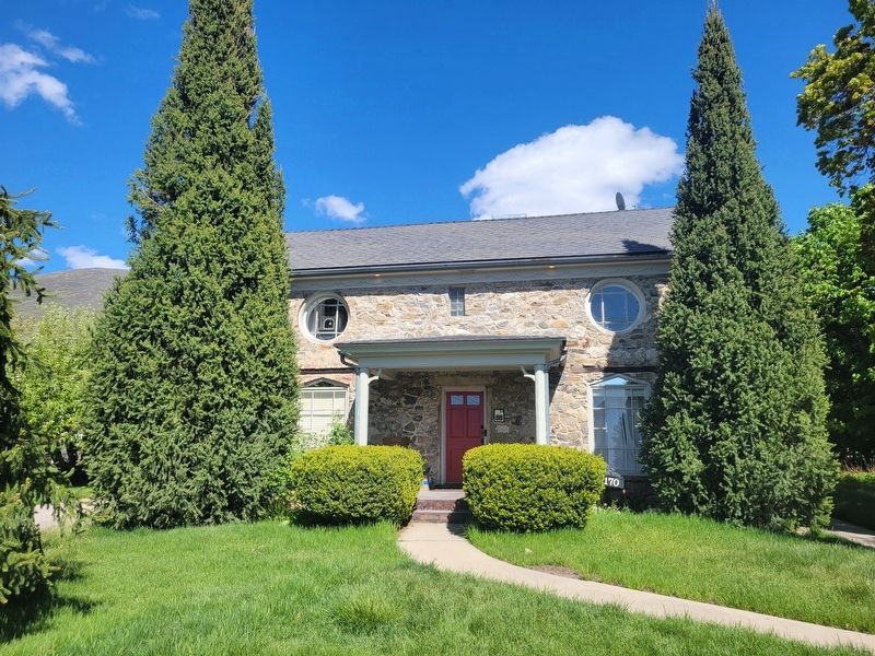
On East Center Street, on the left when traveling west.
This building was originally a stage coach station built and operated in 1866 by William Reeves for the Wells Fargo Company which had control of the Overland Route. After the Utah Central R. R. was completed in 1870, it was abandoned. Mr. Reeves . . . — — Map (db m246345) HM
On East 100 South, on the left when traveling west.
In 1854 Anson Call of Bountiful erected a Grist Mill on the south side of Deuel Creek, just southeast of this marker. The mill was a three-story building made from Centerville Canyon rock, with the machinery on the top floor. The people brought . . . — — Map (db m246340) HM
On North Main Street, on the right when traveling north.
The original one-and-one-half-story stone portion of this house was built
c.1862-66 by Charles Duncan, a skilled Scottish stonemason known for building rock structures throughout Centerville and Farmington, and Thomas Whitaker, who did the . . . — — Map (db m246348) HM
On West State Street at North 200 West, on the right when traveling west on West State Street.
From the spot where you are standing, passengers boarded the Bamberger Railroad's southbound trains. The Farmington Station building, formerly a pioneer schoolhouse, was directly across the street to the east and has since been remodeled into a . . . — — Map (db m225331) HM
On North Main Street, on the left when traveling south.
In memory of Captain Daniel C. Davis in whose honor Davis County was named at its formation Oct. 5, 1850.
Joined L.D.S. Dhurch at Council Bluffs, Iowa, and enlisted in the Mormon Battalion in 1846, where he was Captain of Company E. After . . . — — Map (db m246358) HM
On North Main Street, on the right when traveling north.
This cannon is a replica of a 12 pounder Tredegar Iron Napoleon Confederate Civil War cannon manufactured in Richmond, Virginia in 1864. The original found its way to Farmington and was fired in many community celebrations in the late 1800's . . . — — Map (db m246360) HM
On West State Street at North 200 West, on the right when traveling west on West State Street.
The first Historic District in Davis County to be listed on the National Register, the Clark Lane National Historic District encompasses the homes on State Street (formerly Clark Lane) between 200 West and 400 West. This neighborhood is significant . . . — — Map (db m225332) HM
On North Main Street at E 100 N, on the right when traveling north on North Main Street.
During the late 1800s, this property was used as an LDS tithing lot for hay, grain, and produce. At that time, all of Davis County was one LDS Stake. The president of the Davis Stake was Joseph Hyrum Grant, who resided in Woods Cross, making him . . . — — Map (db m246362) HM
On West State Street near North 200 West, on the right when traveling west.
This home began as a humble, 12-foot square, single-cell house. It was made of sun-dried adobe bricks in 1862 by John Quincy and Minion Leavitt. They soon added a second small room to the first - now the northeast corner of this house. While living . . . — — Map (db m225330) HM
On North South 25 East (Rock Mill Lane), on the right when traveling north.
The Richards Grist Mill, originally known as the
Rock Grist Mill, was owned and operated by S. W. Richards & Co. It was designed and built by Utah millwright Frederick Kesler at the direction of LDS Church President Brigham Young. James Leithead . . . — — Map (db m245980) HM
In 1847 Hector C. Haight settled in North Cottonwood, now Farmington, followed by
others and a ward of the Church of Jesus Christ of Latter-day Saints was organized
1849, Joseph L. Robinson, Bishop. In 1861 this cabin, built for Charles W. . . . — — Map (db m246363) HM
On North Main Street, on the right when traveling south.
Primary Association Organized
The L.D.S. Primary Association, conceived by Aurelia Spencer Rogers, to foster cultural
physical and spiritual activity in children, was organized in this building Aug. 11, 1878.
Aurelia S. Rogers, . . . — — Map (db m246364) HM
On Compton Road north of Main Street, on the left when traveling north.
The original, small rock home at 630 North Main Street in Farmington, Utah, is one of many stone structures that helps set Farmington apart as a city with a distinguishing architectural heritage. The home was built in 1880 by Walter Grover as a gift . . . — — Map (db m146938) HM
On S 100 E at East State Street, on the right when traveling south on S 100 E.
Originally built by Thomas and Electa Hunt in the 1860s, the VanFleet Hotel was probably first used as a residence. Located next to a Wells Fargo
stagecoach stop and county courthouse on what was once the highway
connecting Salt Lake City and . . . — — Map (db m246357) HM
On Crestwood Road at Fairfield Road, on the right when traveling east on Crestwood Road.
George Pilling Adams was born in the old Kay's Ward in 1857 and attended school in what came to be known as Kaysville. George grew up on a farm and became a farmer by trade before his marriage to Ann Eliza Forbes in December of 1876. He built this . . . — — Map (db m125212) HM
On Main Street (Utah Route 273) south of E 100 N, on the right when traveling north.
Built in 1854 by John Weinel a native of Germany who came to Utah about 1853, the mill was the “overshot” water powered type & was erected on Webb’s Creek ¼ mile N.E. of this site. Native stones were used for the walls and pines for it’s . . . — — Map (db m123714) HM
Near North Eastside Drive (U.S. 89), on the right when traveling north.
Born 18 Feb 1792, Vermont. Died 17 Feb 1886, Layton, Utah.
Married Almira Cadwell 1823 and had 7 children.
Married Malinda Railey 1837 and had 7 children.
Elias was a War of 1812 veteran serving in Colonel Forsyth's regiment of riflemen and . . . — — Map (db m133561) HM
On South Main Street, on the right when traveling south.
On this spot stood the Layton Stage Coach Station on the Utah Idaho Montana (Virginia City) trail. It was established in 1857 by Ben Holladay, and carried mail and passengers between Salt Lake and points north and west. Isaac Brown was the keeper. . . . — — Map (db m154484) HM
A close look around this area will reveal what remains of the foundation of the Frary's little home. This modest home was the center of life
for the family. Because of their remote island location, this is where the children
received their . . . — — Map (db m172634) HM
Explorers John C. Fremont and Kit Carson observed several antelope on the island during their 1845 journey, thus giving Antelope Island its name. This was the beginning of the island's recorded history.
An Island of Interest
Herdsman, . . . — — Map (db m243429) HM
A 7.2-mile, earthen causeway follows a natural sand bar extending from this shore area to the northern tip of Antelope Island. It separates Farmington Bay on the south and the main body of the lake. The original road, constructed by Davis . . . — — Map (db m243430) HM
Farmers used bailers in both
hay and grain production.
Hay and straw had to be
hauled to and hand-fed into
the baler for processing. This
process could be dangerous
to operators because their
hands and arms could be
sucked into the . . . — — Map (db m171430) HM
Near Visitors Center Road near Antelope Island Road.
Food for Thought
Brine shrimp are important to the ecology of the Great Salt Lake. The Great Salt Lake is hypersaline, which means that it is many times saltier than the ocean. While fish and frogs cannot tolerate the high . . . — — Map (db m172250) HM
For over half a century, workers harvested grain by hand. This was a very
time consuming process.
By 1900, Island farmers had adopted mechanized grain binders to cut, bundle
and tie grain stalks together into sheaves. Farm hands loaded . . . — — Map (db m171434) HM
The Fielding Garr Ranch was first settled in
1848 and represents 133 years of western ranching
history. While exploring the ranch you will learn
of its colorful past and discover that many periods
of history are represented here. Evidence . . . — — Map (db m171405) HM
Early settlers knew the importance of education. In 1885, a one-room
schoolhouse was constructed on this site, and all 8 grades met together.
Textbooks were scarce, but the students learned reading, writing,
and arithmetic. Unfortunately, most . . . — — Map (db m243441) HM
As evidenced by visible shorelines along the east mountains and Antelope Island, Great Salt Lake is the remnant of ancient Lake Bonneville. Lake Bonneville existed from about 14,000 to 32,000 years ago and covered 20,000 square miles of Utah, . . . — — Map (db m243431) HM
Near 1700 South, on the right when traveling east.
“On March 4, 1905 we moved to Syracuse with all our possessions laoded in an old iron tired wagon. Our furniture consisted of a new bedstead and dresser, and our other household needs. A cupboard, table, chairs, and kitchen stove were all . . . — — Map (db m123765) HM
On Antelope Island Road, on the right when traveling south.
The signature scene, the dangerous buffalo hunt from the movie The Covered Wagon, was filmed on Antelope Island. Released in 1923, it was one of the most successful films of the silent era and the first epic western ever produced. An original . . . — — Map (db m125213) HM
Near Antelope Island Road, on the right when traveling north.
Residents used horse-drawn
wagons on the island
from 1848 through the
1960s due to the prohibitive
cost of hauling fuel to
Antelope Island.
Horse and wagon were used
year-round to haul supplies
anywhere they were needed.
In the . . . — — Map (db m171427) HM
Despite living four miles from their nearest neighbor and having no church, school or town, the Frary children lived very happily on Antelope Island. With imaginations as wide and wild as the landscape around them, they found much to explore. . . . — — Map (db m172637) HM
Near Antelope Island Road, on the right when traveling south.
In 1891 George Frary built a house on this 160 acre homestead. Six years later his wife Alice died and lies
at rest in this burial site.
Frary Family
Father-George Isaac Frary B. Nov. 18, 1854 in Madison, Wisconsin . . . — — Map (db m172272) HM
Employees of the Island
Improvement Company
planted several hundred
acres of hay and 1000
acres of wheat each year
on the Island.
Workers disked new fields
to remove surface weeds
and broke up deeply
compacted soil by using
the . . . — — Map (db m171450) HM
During the 1840s-1850s,
workers harvested grass
hay by hand and loaded it
onto wagons to be stored
for winter feed.
By 1870, field hands
switched to sickle mowers,
like these displayed here,
to harvest their hay. Initially
drawn by . . . — — Map (db m171436) HM
About 1872 the first soil was plowed in this community and in 1876-77 homes were erected. The people attended church services in Kaysville and Farmington prior to 1882 when Pres. Wm. R. Smith of Davis stake organized a branch of the L.D.S. church . . . — — Map (db m123767) HM
The Fielding Garr Ranch operated from 1848 to 1981.
As you walk through the site, see how many different types of building
materials you can identify.
Ranchers used the natural resources of the Isiand for their construction
projects. . . . — — Map (db m171508) HM
On Bluff Road, 0.3 miles north of 2700 South, on the right when traveling north.
The Old Emigrant Road started at Salt Lake City, Utah, and ended at the City of the Rocks, Idaho, where it formed a junction with the California Trail. This road was also known as Bluff Road, Old Traveled Road, and the Salt Lake Cutoff. It was . . . — — Map (db m124032) HM
On Antelope Island Road at Davis County Causeway, on the left when traveling south on Antelope Island Road.
As you survey the vast expanse of inland sea and the causeway fading off into the distance, imagine the days before the causeway existed - nearly seven miles of tangy saltwater separating you from the mainland.
Getting Underway
For . . . — — Map (db m243427) HM
After 1900, farming
activities increased on
the Island.
Tractors became the most
important piece of
equipment at the ranch.
The first tractor you see is
a 1929 Case Model L.
This tractor pulled plows,
powered belt-driven . . . — — Map (db m171451) HM
Transportation to Antelope
Island varied due to
fluctuating lake levels.
In the late 1840s, residents
and visitors came to the
Island by horse and wagon
on buckboards like this one.
By 1853, lake levels rose
enough to make boats . . . — — Map (db m171507) HM
Eventually trucks replaced
wagons as a more efficient
and cost-effective mode
of transportation and
movement of supplies.
During low water years a
sandbar was exposed on the
Southeast end of the Island.
Trucks could cross . . . — — Map (db m171463) HM
On West 1700 South, on the right when traveling west.
The Walker Brothers, James T., Daniel, and Ephraim moved a building owned
by Isaac Barton across the street to this location and opened their store.
The home you see here now was remodeled from that original building. They opened the store in . . . — — Map (db m243428) HM
Among those who homesteaded Antelope Island were George Issac Frary, his wife Alice Eliza Phillips Frary, and five of their seven children Guy, Grace, Lottie, Dora and Frank. This spot is where the family lived, worked and played from 1891 to . . . — — Map (db m172304) HM
Near Antelope Island Road south of Davis County Causeway.
Founder of Great Salt Lake Park First Chairman of Great Salt Lake Authority State Legislature Member of Davis Recreation Committee Syracuse Farmer Sometime known as “Antelope Bill“ “It was on a hot July day in 1959. I had a walk . . . — — Map (db m185675) HM
On North 4000 W, 0.2 miles south of Lake Park Court, on the right when traveling north.
"Following the bluff closely, it [the Hensley Salt Lake Cutoff] intersects Gentile Street, ... from this point the old road is on the location of what is designated as the 'Old Bluff Road'. ... it will continue through lower Syracuse and . . . — — Map (db m169277) HM
On 1800 North (Utah Route 37 at milepost 4), 0.2 miles east of 4325 West, on the right when traveling west.
East side:
The only existing ruts on the Hensley/Salt Lake Cutoff between Salt Lake City and Tremonton are in the field north of this marker. The easterly route went into Brownsville [Ogden] while the westerly Bluff Road, and center . . . — — Map (db m169180) HM
On West Main Street (U.S. 40) at N 100 West Street, on the right when traveling west on West Main Street.
Explorers, trappers and traders were here before Brigham Young sent a group, in 1861, to prepare the way for Mormon colonization. But in October 1861 the U.S. Government set apart Uintah Valley for Indian Reservation. In 1905 a portion was opened . . . — — Map (db m44051) HM
On U.S. 40, 0.1 miles east of East Third Avenue, on the right when traveling east.
In commemoration of the Catholic Priest, Father Escalante, who in 1776 came into Utah. He crossed the Green River at Jensen and camped two days at that place. His diary shows that he camped at the junction of the Strawberry and Duchesne rivers . . . — — Map (db m72764) HM
On Highway 40 (U.S. 40), on the right when traveling west.
Suspicious of the strange Indian leading them ever farther west into unknown territory, the two Spanish priests and their party of horsemen struggled through the canyon of the Strawberry River. Fray Francisco Atanacio Dominguez and Fray Silvestre . . . — — Map (db m239630) HM
On U.S. 40, 0.1 miles east of East 3rd Avenue, on the right when traveling east.
According to one tradition, the Duchesne River was named after Mother Rose Philippine Duchesne.
Mother Duchesne and the Catholic Sisters of the Sacred Heart of Jesus, had started schools in Missouri. The children of many of the early pioneer . . . — — Map (db m72766) HM
On East Main Street, 0.1 miles west of South 100 East, on the right when traveling east.
In 1866-7, U. S. Army made road to Price and Bridge across Duchesne River. At this point Henderson’s Indian Trading Post, Caldwell’s Stage Station and a blacksmith shop were erected. 1905, Army surveyed townsite named for H. P. Myton, Supt. Indian . . . — — Map (db m72760) HM
On Main Street at 300 East, on the left when traveling east on Main Street.
Responding to a call from Brigham Young, Orange Seeley organized groups in Sanpete County to settle Castle Valley. Sheep and cattle men had been here earlier. In 1879 the first settlers located in Castle Dale building their first dugouts under a . . . — — Map (db m147917) HM
On West Main Street west of South 300 West Street, on the right when traveling east.
In 1884 Henry H. Oviatt, Sr. and Samuel N. Alger with their families homesteaded here. When others came, they built a 15 mile irrigation canal, surveying by spirit level and using hand tools. Cleveland Canal & Agricultural Co. organized 1889, to . . . — — Map (db m147925) HM
On North Desert Lake Road, 1 mile east of County Route 211, on the left when traveling east.
1981 In Memory Of
Charles William “Bill” Winder and Caroline Elizabeth Mills
William was the 1st boy born in Desert Lake, Utah, June 28, 1888, to Charles Henry Winder & Helen Pilling. Grandparents: Thomas Harrison Winder & . . . — — Map (db m147926) HM
On East Main Street east of South 100 East, on the right when traveling east.
In 1908 the townsite of Elmo was laid out. Each summer a bowery was erected east of
this site where social events were held. In 1911 a group of men purchased the Cleveland
schoolhouse, dragged it with teams and logs to the bowery lot. It was . . . — — Map (db m147941) HM
On South 100 East south of East Main Street, on the left when traveling south.
Before 1890 Thomas E. Davis filed on land in this vicinity. Others followed, erected homes, a schoolhouse and meeting place. June 16, 1912, a branch of The Church of Jesus Christ of Latter-day Saints was organized, George H. Oviatt presiding elder. . . . — — Map (db m147940) HM
Near Interstate 70 at milepost 106, on the right when traveling west.
When the Mormons fled to Utah in 1847, they were looking for a place nobody else wanted. From Salt Lake City, Brigham Young “called” them to colonize towns and cities all over the great West. The last call came August 22, 1877, when . . . — — Map (db m147829) HM
Near Interstate 70 at milepost 105, on the right when traveling east.
In the 1870s, the Mormon Settlers came east across the Wasatch Plateau to the high mountain deserts of Castle Valley and the San Rafael Swell. It was the last place Mormon colonizer Brigham Young called his people to settle. They were seeking new . . . — — Map (db m147828) HM
On North 100 East north of Main Street, on the left when traveling north.
The Emery LDS Church, built 1898-1900, is the oldest remaining religious building in Emery County. The construction technique, a wood frame sheathed with clapboard and lined with adobe bricks, is distinctive and unusual for turn-of-the-century . . . — — Map (db m147830) HM
Near Interstate 70, 9 miles west of Buckhorn Draw Road (County Road 322), on the right when traveling west.
This is outlaw country! Hidden deep in these canyons, Butch Cassidy, Elza Lay, Flat Nose George, Kid Curry, Joe Walker, and others eluded the lawmen who pursued them in the late 1800s. In the 1850s Chief Wakara escaped into these badlands with as . . . — — Map (db m80465) HM
On Utah Route 10 at milepost 15.5, on the left when traveling north.
From 1885 to 1889, the pioneers who located on the Muddy three miles north east from the town of Emery, built in their poverty a tunnel 1200 feet long through blue slate rock to bring water to the town. Their only tools were pick and shovel and . . . — — Map (db m147840) HM
On North 300 West at West 200 North, on the left when traveling north on North 300 West.
The Presbyterian church entered Utah Territory and expanded rapidly between 1869 and 1883. Around 1911, they erected this building as the Ferron Wasatch Academy, one of forty such institutions in Utah.
These private educational systems led to the . . . — — Map (db m147843) HM
On West 100 North west of State Street, on the right when traveling west.
The first permanent settlers of Ferron arrived Dec. 6,1877. They were Swen Larsen and son Niels Christian Larsen, Nicholas Larsen and wife Helena, Peter F. Peterson and wife, Caroline. The first woman with a family of children, Ann Singleton . . . — — Map (db m147842) HM
At this location in January of 1854, the Great Pathfinder of the American West, John C. Fremont, and 21 other men found themselves in the middle of winter. The explorers were part of Fremont's last expedition of the American west.
Having left . . . — — Map (db m134347) HM
On East Main Street, 0.1 miles west of Holiday River Street, on the right when traveling east.
The first organized attempt to conquer the swirling rapids and precipitous walled canyons of the Green and Colorado Rivers was made by Major John Wesley Powell, Civil War hero and explorer.
Warned by Indians and mountaineers they would never . . . — — Map (db m102089) HM
Henry Mountains Isolated, rugged and remote, the Henry Mountains became the last mountain range to be surveyed in the lower 48 states. In 1872 on John Wesley Powell's second expedition to the area, Powell's bother-in-law, Almon H. Thompson, . . . — — Map (db m141736) HM
Desert Lake, about 8 miles east of here, was first settled in 1885 by settlers building an irrigation ditch from Huntington Creek to the townsite and a reservoir to store the water for farming. In 1896 the dam broke, nearly drowning the small town. . . . — — Map (db m129608) HM
Near Huntington State Park Marina Road near Marina Road, on the left when traveling west.
Hiawatha, about 13 miles NW of this location, was named from Longfellow's poem "Hiawatha." It was incorporated in Sept of 1911. In June of 1912, along with Blackhawk & Mohrland, it was purchased by the U.S. Fuel Company. Coal produced by Hiawatha . . . — — Map (db m101011) HM
On State Highway 31, on the left when traveling south.
In 1875 Leander Lemmon and James McHadden seeking a good range for their horses, found feed plentiful at the mouth of Huntington Canyon and vicinity. Mr. Lemmon brought sheep and cattle from Cottonwood, Salt Lake County. In the autumn of 1876,he . . . — — Map (db m240517) HM
On Main Street at Center Street, on the right when traveling south on Main Street.
January, 1879, Orange Seeley, Presiding Valley Bishop, appointed Elias Cox to preside over the
Latter Day Saints who had settled on Huntington Creek. In October a ward was organized. Logs were
hauled from the canyon and a meeting house erected by: . . . — — Map (db m147922) HM
Near Huntington State Park Marina Road near Marina Road, on the left when traveling west.
Coal was first mined on Cedar Creek, about 9.4 miles N.W. of this location in 1906. Four men named Mays, Orem, Heiner and Rice bought the mines in 1908 and Castle Valley Fuel Co. was formed. In 1909 Castle Valley Fuel Co. became U.S. Fuel Co. and . . . — — Map (db m101010) HM
On Main Street at Center Street, on the right when traveling south on Main Street.
Established as Huntington High School in 1915 with Robert L. Fenton as Principal. In December 1916 the school moved into a new building on the east side of Main street at 100 North. The first senior class consisting of eight girls and two boys . . . — — Map (db m147924) HM
On West 100 North west of West 100 North, on the left when traveling west.
The bell came from the old Relief Society Building . It was cracked by townspeople ringing it at the news of Armistice, 10 October 1918, and was given to the DUP by the Bishop. — — Map (db m155258) HM
On West 100 North west of North 100 West, on the left when traveling west.
This building, erected in 1909 at Bear Creek site was originally the first Ranger Station in Huntington Canyon. John P. Brockbank served as ranger from November, 1909, until November, 1917. Later it was used as summer headquarters by the forest . . . — — Map (db m147920) HM
Robber's Roost was a popular outlaw hideout located along the Outlaw Trail in Southeastern Utah. Sandwiched between the Colorado, Green and Dirty Devil Rivers, the roost is a savage stretch of land crisscrossed with steep-walled canyons, hidden . . . — — Map (db m101214) HM
Wattis Coal Company was organized in 1917 by W.H. Wattis, E.O. Wattis & M.S. Brownin. A surface tramway and 2.5 miles of standard gauge track was built to connect to the Utah RR at Wattis Junction. Coal first went over the tramway in March 1918 . . . — — Map (db m240519) HM
In recognition of the labors of the early coal miners and their contributions to Emery County:
Black Diamond & Oliphant Coal Mines
These two mines, located nearby, are representative of early Utah coal mines.
Production at the two . . . — — Map (db m240513) HM
On West Center Street at South 100 West, on the left when traveling west on West Center Street.
On this site in December 1880, a primitive meeting house was built - a log building which served the community for church, school, dramatic and recreational purposes. Orangeville had been a part of Castle Dale, but in 1882 it was organized as a Ward . . . — — Map (db m147919) HM
On West 100 South at South 100 West, on the left when traveling west on West 100 South.
In 1883 the men and boys of this community brought material from the mountains and built a hall on this spot of ground. They formed a company and rented the hall. The L.D.S. Church purchased the building when Jasper N. Robertson was first Bishop. It . . . — — Map (db m147918) HM
On Horse Canyon Road, on the left when traveling east.
Woodside
The area's first resident was a local prospector named Henry H. Hutchinson, who settled there in 1881. Other homesteaders arrived the next year and started digging an irrigation canal. Attracted by relatively abundant water and an . . . — — Map (db m131511) HM
On Utah Route 22, on the right when traveling east.
In 1873, Albert Guiser and others located in a fertile meadow which they named Grass Valley. Surveyors camped on a stream, lassoed a young coyote and called the place Coyote Creek. The first L.D.S. settlers were Isaac Riddle and family who took up . . . — — Map (db m137023) HM
On Point Lookout Road (Forest Road 1977) 0.2 miles south of Utah Route 12.
“To a life that accepts Nature’s hand in sculpting an individual expression — Nothing is exempt. From the mellifluous rhythm and tone of the wind chime, to the traditional form of the cloud — Nothing exists alone. All things . . . — — Map (db m146683) HM
On Point Lookout Road (Forest Road 1977) 0.2 miles south of Utah Route 12.
Last Link in Highway 12 Pavement Torrey lies just 37 miles from Boulder over Highway 12. But if this mountain route was closed, you'd have to drive more than 200 miles to get there by way of Panguitch. Before the Boulder Mountain section of . . . — — Map (db m146684) HM
On Utah Route 12 west of the road to Bryce Canyon Airport, on the right when traveling west.
Bryce Airport's Vital Role
In this remote region, with major hospitals and airfields hundreds of miles away, Bryce Airport provides critical emergency support. Built in 1936 as an emergency landing strip for commercial airlines, the airport . . . — — Map (db m74765) HM
"Before there were any Indians, the Legend People, To-when-an-ung-wa, lived in that place. There were many of them. They were of many kinds - birds, animals, lizards and such things - but they looked like people....For some reason, the . . . — — Map (db m40537) HM
Union Pacific Railroad served Bryce Canyon well as it grew to national park status. The railroad's vision of the site's potential for tourism culminated in the creation of the "Grand Circle Tour", a tour that traveled to several parks in one trip. . . . — — Map (db m40550) HM
In 1924, when the park was first established, visitors for that year totaled 17,213. A remote locale, poor access, limited on-site accommodations, and few car owners allowed only the elite and the adventurous to come to Bryce Canyon. Twenty years . . . — — Map (db m40533) HM
Near Utah Route 63, 3.7 miles south of Utah Route 12, on the right when traveling south.
He laid the foundation of the National Park Service, defining and establishing the policies under which its areas shall be developed and conserved unimpaired for future generations. There will never come an end to the good that he has done. — — Map (db m40524) HM
In the early 1920s, the Union Pacific Railroad, the National Park Service and the National Forest Service worked together to develop Bryce Canyon as a national park. This collection of cabins and the Bryce Canyon Lodge are a product of that . . . — — Map (db m40558) HM
Before Bryce Canyon was a national park, the Union Pacific Railroad conceived the "Grand Circle" of parks; an area that encompassed Zion National Park, Bryce Canyon, Cedar Breaks and the North Rim of the Grand Canyon. In order for the "Circle" to . . . — — Map (db m40534) HM
On Utah Route 12 at milepost 69, on the left when traveling east.
Skill, Sweat, and Dynamite Before the Highway 12 route was built, traveling through this region was slow, hard work. As late as 1940, Boulder still received its mail by mule train for part of the year. The Civilian Conservation Corps had . . . — — Map (db m146682) HM
On Utah Route 12 at milepost 69, on the left when traveling east.
A Place for Solitude In this vast landscape, you can immerse yourself in the sights, sounds, and textures of the natural world. Listen to a penetrating silence, broken only by the rasping call of a raven overhead. Walk amid rock formations that . . . — — Map (db m146599) HM
On West Main Street at South 100 W, on the right when traveling east on West Main Street.
In 1866, a group of Mormon Cavalrymen noted this valley, while in pursuit of Indians during the Black Hawk War.
In February, 1875, a company of men came from Beaver, Utah and explored the valley. The first permanent settlers came from Beaver, . . . — — Map (db m74744) HM
On North Center Street at West100 N, on the left when traveling north on North Center Street.
In 1876-77 Escalante Pioneers erected a log building, 36 x 18 feet, located 20 feet west of this marker. The logs 18 inches in diameter came from Cyclone Lake Mountain by ox team. They were hewn by hand, fastened with oak pins, morticed ends and . . . — — Map (db m74745) HM
On State Highway 12 at milepost 51.5,, 0.9 miles west of Pet Hollow Road, on the left when traveling west.
Homeland for Many Cultures People have lived in, named, and known this landscape for more than 11,000 years. Artifacts of their lives surround you. Ancient Puebloan peoples came to and through here from many places speaking many languages. . . . — — Map (db m146600) HM
On South Center Street, on the right when traveling south.
This structure, the second public building in Escalante, was erected in 1884 of native stone by Mormon pioneers under the direction of Bishop Andrew P. Schow, Edwin Twitchell and Thomas Heaps. The stone mason was Morgan Richards. It was used to . . . — — Map (db m74746) HM
On Utah Route 12, on the left when traveling east.
The isolated trails between Boulder and Escalante, Utah, were important in the history of the two towns. The foot trail, used by Indians for centuries, connected the two areas and was known as the Death Hollow Trail. Mules, horses, or people . . . — — Map (db m74759) HM
1585 entries matched your criteria. Entries 201 through 300 are listed above. ⊲ Previous 100 — Next 100 ⊳