Near Elmira Road, 1.6 kilometers south of Northside Road (Prince Edward Island Route 16), on the right when traveling south.
English:
The eastern terminus of the Confederation Trail is Elmira. It is a further nine kilometres by road to East Point, the eastern tip of land. The site is dominated by an octagonal white lighthouse built in 1867. Exceeding 19 . . . — — Map (db m141202) HM
Near Elmira Road, 1.6 kilometers south of Northside Road (Prince Edward Island Route 16), on the right when traveling south.
English:
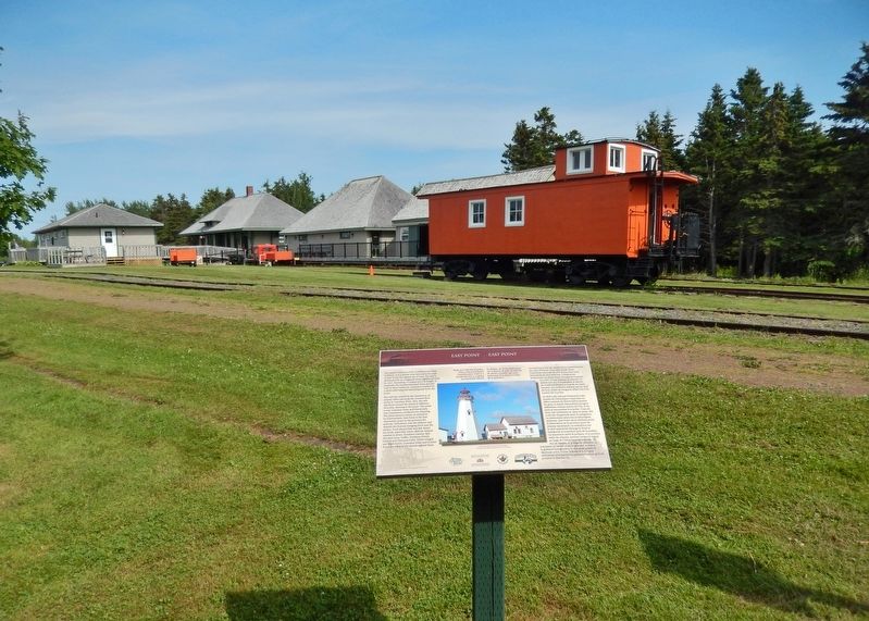
The Elmira Branch of the P.E.I. Railway opened for business on 26 October 1912, one of the last expansions of rail service in the province. The terminus at Elmira was similar to other "ends," with an engine house and . . . — — Map (db m141203) HM
Near Elmira Road, 1.6 kilometers south of Northside Road (Prince Edward Island Route 16), on the right when traveling south.
English:
Elmira became the new eastern terminus of the P.E.I. Railway in 1912 when the main line was extended from Harmony. The early decades of the 1900s were the last period of expansion for the provincial railway. They were . . . — — Map (db m141204) HM
Near Lighthouse Road, 2 kilometers east of East Point Road (Prince Edward Island Route 16), on the right when traveling east.
English:
The original fog alarm building was added to the East Point Light Station in 1885 as a navigational aid. It was replaced in 1908 with a larger building at a cost of $8000.00, and remains one of the few intact fog alarm . . . — — Map (db m140620) HM
Near Georgetown Road near Grafton Street, on the left.
To the glorious memory of
our native sons who paid the supreme
sacrifice in the two World Wars.
1914 — 1918
Our Honoured Dead
Stephen F. Cherry • John P. Dalton • Martin P. Dalton • John W. Lavers • Temple W. Macdonald, M.C. . . . — — Map (db m80294) WM
On Richmond Street close to West Street, on the left when traveling west.
English:
The railway and the steamship lines serving Prince Edward Island became major drivers to a new industry which became known as tourism. Realizing soon after the railway was open for service in 1875 that more and more of their . . . — — Map (db m80298) HM
Near Georgetown Road close to Grafton Street, on the left when traveling south.
English:
The Honorable Andrew Archibald (A.A.) Macdonald
was born February 14, 1829 in Three Rivers.
He carried on the family business in Georgetown
until called to serve in the Legislature.
He was in Ottawa, a member of the . . . — — Map (db m80295) HM
On Richmond Street close to West Street, on the right when traveling west.
English:
The Three Rivers - Montague, Brudenell, and Cardigan - wind through towns, villages and communities in Kings County, draining into Cardigan Bay, known to the Mi’Kmaq people as Samkook (sandy shore). One of the first French . . . — — Map (db m80296) HM
Established in 1720, Havre Saint
Pierre was once the largest
settlement in the colony of Isle Saint
Jean. On a summer day in the 1730s
this was a busy place. Here - a fleet
of tiny shallops, sails snapping as
they set out for the . . . — — Map (db m139397) HM
The bottom of the bay is like a giant compost bin. Seaweed and shellfish collect here when they
die, and form a thick, black mud. The decomposing shells create high lime content, making "mussel
mud” a perfect fertilizer for the . . . — — Map (db m139444) HM
Early British settlers were more
interested in farming than in
fishing. By the early 1800s, a small
village began to grow farther
inland. Here the bay was narrow
and easily crossed - first by ferry,
later by bridge. St. Peters . . . — — Map (db m139407) HM
It is believed that Charles
Sanderson started farming here around 1820. Until the farm was
sold in the early 197os, different
generations of Sandersons cared
for this land. Always mindful of the ever-changing sand dunes, they
helped . . . — — Map (db m139448) HM
Near Black Brook Road, 0.3 kilometers north of Cape Bear Road (Prince Edward Island Route 18), on the right when traveling north.
John Whalen built the square tapered, 12.4 m Cape Bear Lighthouse in 1881. In 1947, it was moved back from eroding cliffs. Ewart A. Keeping was lightkeeper from 1926-1959. The attached dwelling was removed in 1960. The Marconi Wireless Station was . . . — — Map (db m198787) HM
On Station Lane just south of Cape Bear Road (Main Street) (Prince Edward Island Route 18), on the right when traveling south.
English:
Cape Bear is located on the Northumberland Strait side of the southeast corner of Prince Edward Island. The name survives in translation from the French period of Island history. The lighthouse was built in 1881, one of . . . — — Map (db m147964) HM
On Station Lane just south of Cape Bear Road (Main Street) (Provincial Route 18), on the right when traveling south.
English:
The normal way to build a railway is to start at one end using an engine and flatcars to deliver materials to the end-of-track. The branch built between Charlottetown and Murray Harbour between 1901 and 1904 required a . . . — — Map (db m147962) HM
On Main Street (Prince Edward Island Route 18) just north of Cape Bear Road (Prince Edward Island Route 18A), on the right when traveling south.
In grateful tribute to the living
and the dead who through their
valiant efforts and bitter
sacrifice have made Canada great
is this shrine dedicated Killed in action or died in service War of 1914-1918
Gordon Mackay
Clarence Reynolds . . . — — Map (db m139450) WM
On Main Street (Prince Edward Island Route 18) just north of Westview Drive, on the right when traveling west.
English:
Murray Harbour began to achieve status as an important PEI port in the late 1700s. The earliest settlers in the area sustained themselves by fishing and farming but John Cambridge, the proprietor of Lot 64, was actively . . . — — Map (db m140239) HM
On Station Lane just south of Cape Bear Road (Main Street) (Prince Edward Island Route 18), on the right when traveling south.
English:
A well-protected fishing harbour lies a short distance down the South River from the end of the trail. Fishing boats are lined up on both sides of the waterway and storage sheds dominate the wharves. The quiet ripple-free . . . — — Map (db m147963) HM
On School Street just west of Main Street (Prince Edward Island Route 4), on the left when traveling west.
English:
The original planners of the P.E.I. Railway in the early 1870s were very focused on connecting all of the major Island ports. The export of farm produce was at the heart of the economy. The railway made it easier for . . . — — Map (db m147965) HM
On Woodside Shore Road north of Prince Edward Island Route 112, on the left when traveling north.
English: James Colledge Pope was born in Bedeque. A successful merchant and shipbuilder, he entered political life in 1857. Premier of the Island on two previous occasions (1865-7 and 1870-2), he again assumed that office in April, 1873, and . . . — — Map (db m137724) HM
Near Commercial Street just west of Broadway Street North (Prince Edward Island Route 20), on the right when traveling west.
English: Being a stop along the PEI Railway route brought the possibility of prosperity. With construction about to begin, communities across the province were vying to have the tracks pass through their town or village. This . . . — — Map (db m148800) HM
Near Imperial Street just north of Commercial Street, on the left when traveling north.
English: The old expression “A woman's work is never done” was never more true than in the case of farm women. Farm women had many tasks. They worked to keep the farm's milk cool during the summer. This could . . . — — Map (db m149996) HM
Near Imperial Street just north of Commercial Street, on the left when traveling north.
English: The silver fox industry is a fascinating era in Island farming history. By the turn of the century, P.E.I. had gained attention as the world leader in this rare commodity. Robert Humphrey, of Kensington, was one of the . . . — — Map (db m150000) HM
Near Imperial Street just north of Commercial Street, on the left when traveling north.
English: Built in 1960 by Montreal Locomotive Works… …Engine 1762 was first put into service as Engine 3859 at the Montreal Yard Diesel Shop. When Canadian National began changing its entire line to diesel, the engine was . . . — — Map (db m148806) HM
Near Imperial Street just north of Commercial Street, on the left when traveling north.
English: With new amenities that allowed farmers to heighten production, and rising market demand, the local farming sector responded by developing a wide range of new institutions and organizations. Canada Packers opened a branch . . . — — Map (db m149993) HM
Near Commercial Street east of Imperial Street, on the left when traveling east.
English: With its debt in hand, there were other challenges in store for the PEI Railway. The Island's soil is excellent for farming, but makes a poor foundation for train tracks. Millions of tons of mainland gravel were . . . — — Map (db m148801) HM
Near Imperial Street just north of Commercial Street, on the left when traveling north.
English: On 16 November, 1990, Engine 1762 was relocated to Kensington… …where it stands today as an icon of PEI's Age of Rail. A payloader pushed the 125-ton engine along the tracks as far as New Annan where the rails had been . . . — — Map (db m148808) HM
Near Imperial Street just north of Commercial Street, on the left when traveling north.
English: Farming families were not only concerned with their own back forty: they also established many organizations promoting the well-being of the entire community. Farm organizations did much, for instance, to promote . . . — — Map (db m150001) HM
Near Commercial Street east of Imperial Street, on the left when traveling east.
English: Joining the Confederation was as much a financial consideration… …for PEI as it was a matter of national pride. The fact was that the railway was only a little more than half finished when the money borrowed to build . . . — — Map (db m148802) HM
On Broadway Street North (Prince Edward Island Route 20) just north of Commercial Street, on the left when traveling north.
English:
In 1871 the Colony of Prince Edward Island embarked upon the construction of a circuitous 147-mile railway covering the 120-mile distance between Georgetown and Alberton. The high cost of building the line added . . . — — Map (db m139700) HM
Near Imperial Street just north of Commercial Street, on the left when traveling north.
English: Successful farming meant owning healthy, hard-working livestock. Cattle, pigs, and chickens not only produced the milk, meat, and eggs for the family, but also provided a source of steady income. At one time, horsepower had . . . — — Map (db m149999) HM
Near Imperial Street just north of Commercial Street, on the left when traveling north.
English: With its rich soil, Prince Edward Island is tailor-made for the cultivation of potatoes. Early settlers planted potatoes because they would grow on the newly-cleared land, thriving even when planted amongst the tree stumps. . . . — — Map (db m149998) HM
Near Imperial Street just north of Commercial Street, on the left when traveling north.
English: With rail service a thing of the past, Summerside resident Lowell Huestis… …set about preserving mementos. Aided by the Summerside Chamber of Commerce, he arranged to have Engine 1762 moved from the Summerside . . . — — Map (db m148807) HM
Near Commercial Street just east of Imperial Street, on the left when traveling east.
English: By 1950, The Age of Steam was about to become The Age of Diesel. Steam engines burned coal to heat water, creating pressurized steam to drive the pistons. Crew members called Firemen performed the dangerous job of . . . — — Map (db m148804) HM
Near Imperial Street just north of Commercial Street, on the left when traveling north.
English: For early farmers, insect control was not a complicated process. The first widely used pesticide, Paris Green, battled the Colorado Potato Beetle, and had to be applied to the potato plants manually. A sprayer was developed . . . — — Map (db m149994) HM
Near Imperial Street just north of Commercial Street, on the left when traveling north.
English: Most Island family farms practiced “mixed farming.” Rather than specializing in one agricultural sector early farms kept a variety of animals and planted many different crops. These small farms were remarkably . . . — — Map (db m149997) HM
Near Commercial Street east of Imperial Street, on the left when traveling east.
English: Despite its challenges, the PEI Railway began operation on 25 May, 1875… …and Kensington Station was a major stop and switchyard. Before plans for the PEIR had been announced, Kensington had been little more than a . . . — — Map (db m148803) HM
Near Imperial Street just north of Commercial Street, on the left when traveling north.
English: Farmers have almost always practiced crop rotation to preserve the soil. Potatoes absorb more nutrients than crops such as hay or grain. To prevent the land from becoming depleted, the farmer rotates the crop making certain . . . — — Map (db m149995) HM
Near Commercial Street east of Imperial Street, on the left when traveling east.
English: Recognized for its unique architecture and cultural significance… …Kensington Station was designated a National Historic Site in 1978. During a federal government survey in 1873, the original structure was found to be . . . — — Map (db m148809) HM
Near Anderson Road (Prince Edward Island Route 225) just east of Somerset Street (Prince Edward Island Route 109), on the right when traveling east.
English:
The first settlers in Kinkora were farmers. The community that developed has depended upon agriculture ever since. After the Dominion Government launched a dairy initiative in 1891, Kinkora responded and in 1900 opened a . . . — — Map (db m141171) HM
Near Anderson Road (Prince Edward Island Route 225) just east of Somerset Street (Prince Edward Island Route 109), on the right when traveling east.
This granite mill stone was mfg in France in the late 1800’s and imported to PEI in 1890’s. Mill stones were used in cereal grain grist mills to crush various cereal grains to yield flour for bread. This mill stone was purchased and used by Patrick . . . — — Map (db m151773) HM
Near Anderson Road (Prince Edward Island Route 225) just east of Somerset Street (Prince Edward Island Route 109), on the right when traveling east.
English:
The poetry of Ireland is immediately evident in a name that explains much about the community in and around the village. Building the Anderson Road in 1832 opened up the district for farming. Irish families, experienced . . . — — Map (db m141170) HM
Near Lady Slipper Drive North (Prince Edward Island Route 12) 0.1 kilometers north of Main Drive East (Veteran's Memorial Highway) (Prince Edward Island Route 2), on the right when traveling north.
Français:
Du 13 au 15 août 1884, Miscouche est la scène de la deuxième Convention nationale des Acadiens. Quelque 150 délégués officiels des trois provinces Maritimes se réunissent pour poursuivre les discussions entamées en 1881 . . . — — Map (db m142398) HM
On Main Drive East (Veteran's Memorial Highway) (Prince Edward Island Route 2) just east of Lady Slipper Drive North (Prince Edward Island Route 12), on the left when traveling east.
Français:
Fondée en 1889 par le curé de la paroisse, la Fanfare de Miscouche constitue une institution culturelle importante pour la communauté. Elle porte d'abord le nom Heckman Band en l'honneur du dentiste local qui fit un don . . . — — Map (db m142400) HM
Near Main Drive East (Veteran's Memorial Highway) (Prince Edward Island Route 2) 0.2 kilometers east of Lady Slipper Drive North (Prince Edward Island Route 12), on the left when traveling east.
Français:
Vers 1808, des familles écossaises catholiques, les Steele, McNeil et Gillis, sont les premières à s'établir dans l'emplacement actuel de Miscouche. En 1816, un groupe de familles acadiennes, qui habite la baie de . . . — — Map (db m142394) HM
Near Lady Slipper Drive North (Prince Edward Island Route 12) 0.1 kilometers north of Main Drive East (Veteran's Memorial Highway) (Prince Edward Island Route 2), on the right when traveling north.
Français:
Le Couvent Saint-Joseph a la particularité d'avoir été le premier couvent-école dans une paroisse acadienne à l'Île-du-Prince-Édouard et au Nouveau-Brunswick. Ouvert en 1864, et agrandi en 1922, il est placé sous la . . . — — Map (db m142399) HM
On Lady Slipper Drive North (Prince Edward Island Route 12) just north of Main Drive East (Veteran's Memorial Highway) (Prince Edward Island Route 2), on the right when traveling north.
Français:
En 1890, la paroisse de Miscouche compte 683 Acadiens francophones et 137 anglophones, principalement d'origine écossaise. La majorité des paroissiens vivent sur la ferme, bien que les activités économiques sont assez . . . — — Map (db m142396) HM
On Lady Slipper Drive North (Prince Edward Island Route 12) just north of Main Drive East (Veteran's Memorial Highway) (Prince Edward Island Route 2), on the right when traveling north.
Français:
La première église paroissiale a été construite en 1819. L'église actuelle, la troisième, a été érigée en 1891-92 selon les plans de l'architecte insulaire George Edwin Baker, pendant la cure du père John A. MacDonald. . . . — — Map (db m142397) HM
Near Main Drive East (Veteran's Memorial Highway) (Prince Edward Island Route 2) 0.2 kilometers east of Lady Slipper Drive North (Prince Edward Island Route 12), on the left when traveling east.
Français:
Le premier établissement acadien sur les rives de la baie de Malpèque remonte à 1728. Il était situé du côté ouest là où se trouve aujourd’hui la région de Port Hill. En 1752, cette communauté agricole comptait 32 . . . — — Map (db m142401) HM
On Main Drive East (Veteran's Memorial Highway) (Prince Edward Island Route 2) 0.2 kilometers east of Lady Slipper Drive North (Prince Edward Island Route 12), on the left when traveling east.
Français:
De 1881 à 1937, les conventions ont favorisé l’éveil du sentiment national et l’affirmation du peuple acadien. Organisées par la Société nationale de l'Assomption, elles ont joué un rôle important dans la sauvegarde du . . . — — Map (db m140000) HM
On Main Drive East (Veteran's Memorial Highway) (Prince Edward Island Route 2) just east of Lady Slipper Drive North (Prince Edward Island Route 12), on the left when traveling east.
Français:
La Base militaire de Summerside a eu un impact important sur la vie socio-économique de Miscouche pendant les 50 années de son existence (1941-1991). De nombreux paroissiens y ont trouvé de l'emploi et la communauté . . . — — Map (db m142395) HM
Near Veteran's Memorial Highway (Prince Edward Island Route 2) at Rafferty Road (Prince Edward Island Route 12), on the right when traveling west.
English: There are three old railway stations across the province that remain near the trail but which are on their last legs. They are in West Devon, Fredericton and York. None of the three belong to the trail, having been hauled . . . — — Map (db m151787) HM
Near Veteran's Memorial Highway (Prince Edward Island Route 2) at Rafferty Road (Prince Edward Island Route 12), on the right when traveling west.
English: Wetland around Portage is extensive; the water table is not far from the surface. This is the narrowest part of Prince Edward Island, about 3.5 kilometres (just over two miles) between the Percival River to the south and . . . — — Map (db m151788) HM
On Western Road, 0.1 kilometers north of Macisaac Road (Prince Edward Island Route 127), on the right when traveling north.
English: About the time of Confederation, Wellington was a small rural community located around Goodwin's Corner on the western road. It was named after Arthur Wellesley, the Duke of Wellington; the British general who defeated . . . — — Map (db m151770) HM
On Summer Street just north of Fitzroy Street, on the left when traveling south.
English:
This structure, built 1883-1886, was designed under the direction of Thomas Fuller who served as Chief Architect of the Department of Public Works from 1881 to 1896. This basic design with a double entrance, steep roof, . . . — — Map (db m139466) HM
On Summer Street just south of Fitzroy Street, on the left when traveling south.
English:
Born in Charlottetown, Georgina Pope chose nursing as a career. After training and working in the United States, she was selected in 1899 to superintend Canada’s military nurses in the South African War. She was the first . . . — — Map (db m139478) HM
On Water Street (Prince Edward Island Route 11) at Granville Street, on the right when traveling east on Water Street.
The Prince Edward Island Railway began operating in 1875. Its establishment was accomplished largely through the efforts of two Summerside brothers, James Colledge Pope, who was Premier when the Railway Bill was passed in 1871, and William Henry . . . — — Map (db m141019) HM
On Granville Street just south of Water Street (Prince Edward Island Route 11), on the left when traveling south.
The Prince Edward Island Railway was established in 1871. By 1874 there were 70 stations across the Island, including an open-ended "Terminal" Station about a mile north of the Summerside harbour. A track ran down to the waterfront where the . . . — — Map (db m141017) HM
On Summer Street south of Fitzroy Street, on the left when traveling south.
The Summerside Armoury has been a landmark on Summer Street since 1911. An Armoury is a military structure where arms, ammunition and military equipment are stored. It serves as the headquarters for a militia, a volunteer army made up of local . . . — — Map (db m139479) HM
Near Point Prim Road (Prince Edward Island Route 209) 11 kilometers west of Trans-Canada Highway (National Route 1).
English:
Despite its initial success, the Prince Edward Island Steam Navigation Company and its vessel, the St. George, ran into difficulties. Even with investments from New Brunswick and Nova Scotia, steamboats were . . . — — Map (db m140249) HM
Near Point Prim Road (Prince Edward Island Route 209) 11 kilometers west of Trans-Canada Highway (National Route 1).
English:
Prince Edward Island's contribution to Nova Scotia's lighthouses inspired the question: What about building a lighthouse here?
Petitions for lighthouses began to appear before government by the late 1830s. Concerned . . . — — Map (db m140246) HM
Near Point Prim Road (Prince Edward Island Route 209) 11 kilometers west of Trans-Canada Highway (National Route 1).
English:
At the same time that the Island was grappling with the issue of lighthouses, it found itself dealing with an issue of a different sort: Mail delivery.
Mail delivery was very important, representing the Island's . . . — — Map (db m140247) HM
Near Point Prim Road (Prince Edward Island Route 209) 11 kilometers west of Trans-Canada Highway (National Route 1).
English:
Late in the summer of 1864, two events descended upon the city of Charlottetown. One was a circus; the other, a political conference. Of the two, it was the circus that captured the attention of Islanders. But it was the . . . — — Map (db m140250) HM
Near Point Prim Road (Prince Edward Island Route 209) 11 kilometers west of Trans-Canada Highway (National Route 1).
English:
Imagine being aboard a ship on a dark, stormy night. The wind is howling fiercely, pushing large waves over the sides of your vessel. You are at the mercy of the elements. Picture a lack of navigational aids, creating a . . . — — Map (db m140245) HM
On Canoe Cove Road (Prince Edward Island Route 19A) just north of Prince Edward Island Route 19, on the left when traveling north.
The School For more than a century the Canoe Cove School provided state-of-the-art education to students grades one through ten. This sturdy heritage building launched the successful careers of doctors, lawyers, nurses, teachers, . . . — — Map (db m139457) HM
History of the Cavendish Area.
There is archaeological evidence that ancestors of the present-day Mi’kmaq lived on the shores of nearby New London Bay. It is very likely these early Islanders would have travelled here to hunt, . . . — — Map (db m139369) HM
25 July, 1883. Thanks to a weekend of violent storms there is a heavy sea running. A few farmers watch with astonishment as a magnificent sailing vessel, driven by a mountain of canvas, slams onto the Cavendish sandbars. The air iš alive . . . — — Map (db m139391) HM
Sea Stories From the first peoples through modern times, the fishery has been vital
to the people living along this shore. As Lucy Maud Montgomery
remembered: Many of the farmers had a fishing house on the shore field
of their . . . — — Map (db m139429) HM
Toward the end of the 1800s, Prince Edward Island became known as an excellent vacation spot. Its clean air, rural landscapes and beautiful beaches were offered to travellers made weary by the stress of urban
life. By the 1920s, thanks . . . — — Map (db m139431) HM
Near Cavendish Road (Prince Edward Island Route 6) close to Prince Edward Island Route 13, on the right when traveling east.
English:
Internationally renowned author, Lucy Maud Montgomery was born in New London, Prince Edward Island. After her mother's death in 1876, she lived with her maternal grandparents in Cavendish until 1911, when she married and moved to . . . — — Map (db m80283) HM
Near Grafton Street at Great George Street, on the right when traveling north.
English:
1864 was an important year in Charlottetown. The Charlottetown Conference, held in September, gave delegates from Nova Scotia, New Brunswick, Prince Edward Island and the colony of Canada one week to meet, share ideas, . . . — — Map (db m141114) HM
On Water Street (Prince Edward Island Route 1) at Grafton Street, on the left when traveling north on Water Street.
English: The Confederation Centre of the Arts was officially opened by Queen Elizabeth II on October 6, 1964 as a living memorial to the Fathers of Confederation. Located beside Province House in Queen Square, it was designed by the . . . — — Map (db m149912) HM
On Queen Street at Grafton Street, on the left when traveling south on Queen Street.
English: This cannon fell off a cliff near Fort Amherst and landed in Charlottetown Harbour. Pulled from the water by Theophilus DesBrisay, it was brought into town and placed in the ground outside his family's drug store, . . . — — Map (db m149597) HM
On Grafton Street at Great George Street, on the right when traveling east on Grafton Street.
English: A Neoclassical Design
Have you ever noticed that the building's design, including features such as columns and windows, is pleasingly symmetrical? This is one of the features that make Province House a fine example of . . . — — Map (db m137659) HM
On Grafton Street at Water Street (Prince Edward Island Route 1), on the right when traveling east on Grafton Street.
English: "From the beginning, the river drew people to settle its banks and use its waters to reach the settlements..." The Hillsborough River, Elsitkuk as the Mi'kmaq would say, is the Island's largest river. It runs east . . . — — Map (db m149601) HM
On Water Street east of Queen Street, on the right when traveling east.
English: The Bonded Warehouse across the street was often at the centre of one of Charlottetown's most controversial issues: prohibition. In 1901 Prince Edward Island was the first Canadian province to make it illegal to possess, . . . — — Map (db m149598) HM
On Rochford Street close to All Souls' Lane, on the right when traveling north.
English:
This 1888 chapel, designed by William Critchlow Harris, Jr., is a masterful example of High Victorian Gothic Revival architecture in Canada. Its robust design is distinguished by rough textures in rust-red Prince Edward Island . . . — — Map (db m80226) HM
English:
Born at Three Rivers, Brudenell Point, Macdonald, a merchant and shipbuilder, served as a member of the Legislative Assembly (1853-58) and of the Legislative Council (1867-72). He attended the Charlottetown and Quebec Conferences . . . — — Map (db m80271) HM
On Veterans Memorial Highway (St. Peters Road) (Prince Edward Island Route 2) just south of Oakland Drive, on the left when traveling south.
In 1786 John Cambridge purchased approximately 300 acres along Wright's Creek, which was then called Bird Island Creek. Around 1800 he built a 22 foot-high mill dam at the head of tide on the creek, and went on to build a saw mill, grist mill and . . . — — Map (db m140303) HM
On Great George Street at Dorchester Street, on the right when traveling south on Great George Street.
Angus Bernard MacEachern (1759-1835), first Bishop of the
Diocese of Charlottetown, founded St. Andrew's College,
the first post-secondary institution in the colony, on 30
November 1831. In January 1855, the college was re-located
and . . . — — Map (db m201602) HM
On Queen Street at Grafton Street, on the right when traveling south on Queen Street.
English:
On December 24, 1810, Thomas Desbrisay Jr. opened an apothecary shop on this site to supply drugs and medicine to the people of Prince Edward Island. Until then, many Islanders relied more on home remedies or obtained medicines . . . — — Map (db m80262) HM
On Kent Street south of West Street, on the left when traveling south.
English: Built in 1877 for James and Edith Peake, Beaconsfield was one of Prince Edward Island's most elegant homes. Featuring the finest in materials and craftsmanship, it was also equipped with all the latest conveniences of the . . . — — Map (db m149595) HM
On Grafton Street at Water Street (Prince Edward Island Route 1), on the right when traveling east on Grafton Street.
English: Across Charlottetown Harbour on the west side was the home base for the Acadians in the early years of the 1700's. It was called Port-la-Joye and Fort Amherst by the English. The Mi'kmaq called it Skma qan which . . . — — Map (db m149600) HM
On Kent Street just south of Queen Street, on the left when traveling north.
This bell was affectionately known as “Big Donald” honouring Fire Chief Donald MacKinnon 1875-1879. Cast in 1875 by William Blake & Co., formerly H.W. Hooper & Co., Boston, Mass. Cracked and recast in 1877 Cracked and recast in 1884 . . . — — Map (db m149596) HM
On Water Street (Prince Edward Island Route 1) at Grafton Street, on the left when traveling north on Water Street.
English: Even though it was the capital of Canada's smallest province, it took almost 100 years before Charlottetown became of strong historical importance. On August 31, 1864 the delegates began arriving for what is now referred to . . . — — Map (db m149905) HM
On Kent Street close to Pownal Street, on the left when traveling east.
This marker is composed of two plaques on either side of the entrance.
In 1930, the Canadian National Railway (CNR) decided to build a hotel in Charlottetown, Railway hotels were the standard of comfort and service, but the new Canadian . . . — — Map (db m80227) HM
On Kent Street near Queen Street, on the left when traveling east.
Samuel Holland Report Sept 14, 1767
The Capital to be called Charlotte Town is proposed to be built on a point of the harbor of Port Joy, betwixt York and Hillsborough Rivers, as being one of the best, and nearly central Parts of the . . . — — Map (db m207811) HM
On Richmond Street at Great George Street, on the right when traveling west on Richmond Street.
These pivotal meetings laid the groundwork for Canadian Confederation. Here in September 1864, the Charlottetown Conference brought together leaders from the colonies of Prince Edward Island, Nova Scotia, New Brunswick, and the Province of Canada . . . — — Map (db m200977) HM
On Queen Street near Kent Street, on the right when traveling south.
English:
Built in 1888, the Charlottetown City Hall is the oldest municipal hall in Prince Edward Island. Designed by Phillips and Chappell in the Romanesque Revival style often favoured for 19th-century civic buildings, it originally . . . — — Map (db m80230) HM
On Weymouth Street at Water St, on the right when traveling north on Weymouth Street.
Built of Island and Wallace Sandstone, the Charlottetown railway station opened July 8, 1907. At a time when both people and goods travelled extensively by train, the station was a busy place indeed. Housing public facilities and administrative . . . — — Map (db m201323) HM
On Grafton Street at Water Street (Prince Edward Island Route 1), on the right when traveling east on Grafton Street.
English: Charlottetown is the home of two important educational institutions. The University of Prince Edward Island was established in April 1969. It resulted from a merger of two institutions: Prince of Wales College that began as . . . — — Map (db m149899) HM
English:
Born in Charlottetown, a Father of Confederation, Gray served in the Imperial cavalry (1831-52) before entering politics. Elected in 1858 to represent Queen's County, he served as Premier of the province (1863-65) and played a . . . — — Map (db m80269) HM
On Grafton Street at Queen Street, on the right when traveling east on Grafton Street.
English:
Opened by Her Majesty the Queen in 1964 as Canada's National Memorial to the Fathers of Confederation, the Centre is an outstanding example of an institution dedicated to the arts. The extensive cultural complex includes a . . . — — Map (db m80264) HM
On Water Street at Haviland Street on Water Street.
English:
This apartment building, completed in 1890, is a handsome example of the Queen Anne Revival in Canada. Admired for its picturesque qualities, this style was popular in Canadian domestic architecture from the 1880s to the 1910s. As . . . — — Map (db m80207) HM
Near Richmond Street close to Great George Street.
English:
Born in Charlottetown and called to the bar in 1831, Palmer was a member of the legislature (1835-60), and of the Legislative Council (1860-73). Between 1848 and 1873 he held several cabinet posts, including that of President of . . . — — Map (db m80270) HM
Near Richmond Street close to Great George Street.
English:
Born in Ireland, Whelan immigrated to Halifax c. 1836 and became a protégé of Joseph Howe. As a journalist in Charlottetown be published the short- lived Palladium in 1845, became editor of the Morning News in 1846, . . . — — Map (db m80266) HM
English:
A native Prince Edward Islander, Coles, first elected in 1842, represented the constituency of Queen's in the House of Assembly of the Island until his retirement because of ill health in 1868. Co-founder, with Edward Whelan, of . . . — — Map (db m80273) HM
English:
Great George Street is richly evocative of both its 18th-century origins and its subsequent development as one of Charlottetown's principal streets. Clearly focused to Province House, the seat of Island government and the . . . — — Map (db m80200) HM
155 entries matched your criteria. The first 100 are listed above. The final 55 ⊳