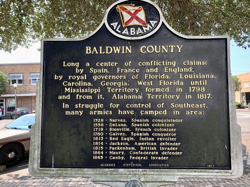
On Courthouse Square (U.S. 31) at Hand Avenue, on the left when traveling east on Courthouse Square.
Third oldest county in Alabama.
Created in 1809 while still part
of Mississippi Territory.
Named for Abraham Baldwin (1754-1807)
founder of University of Georgia,
delegate to Constitutional Convention,
member of Congress, 1789-1807. . . . — — Map (db m100839) HM
On Eastern Shore Trail south of Taylor Street, on the left when traveling north.
Near here at junction of Rock Creek and Mobile Bay lies Ecor Rouge, highest coastline point between Maine and Mexico. Aboriginal Indians held powwows and made pottery here. The red cliff, a mariners' landmark on Spanish maps of 1500's, called Ecor . . . — — Map (db m257464) HM
(East Face):
Tribute dedicated to the memory of the soldiers who gave their lives in the defense of our country here at Fort Morgan.
Here lies the pride of seven flags entombed in our ancestor’s worth, who heard the thunder of the fray . . . — — Map (db m4649) HM
On Spanish Fort Boulevard (U.S. 90/98) at Spanish Main, in the median on Spanish Fort Boulevard.
Spanish Fort is the gateway to the second largest delta in the United States. The Mobile-Tensaw, River Delta is 30 miles long and 12 miles wide. It covers more than 200,000 acres of swamps, river bottomlands and marshes and is considered the best . . . — — Map (db m285174) HM
On Alabama Route 59 at milepost 56, on the right when traveling north.
William Bartram, America’s first native born artist - naturalist, passed through Baldwin County during the Revolutionary era, making the first scientific notations of its flora, fauna and inhabitants. As the appointed botanist of Britain’s King . . . — — Map (db m81855) HM
On Alabama Route 225 just north of Lower Bryants Landing Road, on the left when traveling north.
Here on the banks of the Tensaw River -- named for the Tensa Indian tribe whose principal village was located at this place -- Major Robert Farmar developed a plantation c. 1772. Farmar was one of the most prominent and controversial Alabamians of . . . — — Map (db m66380) HM
On Sherling Lake Road (County Road 44) 1 mile west of Braggs Road (State Route 263), on the right when traveling west.
William Bartram, America's first great naturalist, passed through northwest Butler County in July 1775. He described the "limestone rocks" and "banks of various kinds of sea shells" left by oceans that covered this area millions of years ago, and . . . — — Map (db m120937) HM
On State Line Road (County Route 212) 0.1 miles south of North State Line Road, on the right when traveling north.
A flourishing, ancient town of the Muscogee Indians known as Ocfuskooche Tallahassee (Old Town) stood on this site. English traders from Charles Town visited it about 1685. A trail known as "Old Horse Path" led from this village to the Tallapoosa. . . . — — Map (db m36315) HM
On Barlow Bend Road 0.2 miles north of Madison Road (Route 33), on the left when traveling north.
First church building of record in Clarke County.
Erected here in 1810 by John French of Virginia,
who organized Methodist congregation here 1811.
Combined with Gainestown Church 1897. — — Map (db m101575) HM
On Rockville Road (County Road 15) at Stimpson Sanctuary Road, on the right when traveling south on Rockville Road.
William Bartram, America’s first native born artist-naturalist, passed through Clarke County during the Revolutionary era, making the first scientific notations of its flora, fauna and inhabitants. As the appointed botanist of Britain’s King George . . . — — Map (db m101568) HM
Near Interstate 20 (Interstate 20) west of Route 37, on the right when traveling west.
Hernando De Soto in Alabama
Hernando de Soto brought his 700-man army to Alabama in the fall of 1540. This was the first major European expedition to the interior of the southeastern United States. The De Soto expedition had landed at Tampa . . . — — Map (db m114373) HM
On County Road 1 at State Route 83, on the right when traveling south on County Road 1.
For a few months between 1811—1818 the nationally infamous highwayman, Joseph Thompson Hare, operated with his gang along the Federal Road. They headquartered at Turk's Cave near Brooklyn in Conecuh County. In his confession he referred to the . . . — — Map (db m81282) HM
On Citizens Parkway (Alabama Route 22) 0.2 miles north of Singleton Drive, on the right when traveling north. Reported missing.
Colony’s north boundary
crossed present-day
Alabama - Mississippi
at this point on 32° 28’
by edict of British king.
Colony extended south to Gulf.
France had ceded area in 1763.
Spain invaded, seized area in . . . — — Map (db m37644) HM
Near Interstate 59 1 mile north of County Road 140, on the right when traveling south.
Hernando De Soto brought his 700-man army to Alabama in the fall of 1540. This was the first major European expedition to the interior of the southeastern United States. The De Soto expedition had landed at Tampa Bay, Florida, in the spring of . . . — — Map (db m213362) HM
Near Interstate 59 1 mile north of County Road 140, on the right when traveling south.
1492 - Columbus visits Caribbean islands
1519 - Pineda visits Mobile area
1528 - Narváez reaches Mobile area
1540 - De Soto explores Alabama
1559 - De Luna retraces De Soto's route in Alabama
1702 - French establish first . . . — — Map (db m213363) HM
On West Fort Toulouse Road 0.1 miles west of U.S. 231, on the right when traveling west.
William Bartram, America’s first native born artist-naturalist, passed through Elmore County during the Revolutionary era, making the first scientific notations of its flora, fauna and inhabitants. In 1776 the appointed botanist of Britain’s King . . . — — Map (db m69431) HM
Near West Fort Toulouse Road 0.2 miles south of Jackson Park Road.
William Bartram, the first native-born American artist-naturalist, of Philadelphia, visited this site on Christmas Day, 1776.
This arboretum commerates (sic) the man, his visit to Fort Toulouse, and his travels through the southeastern . . . — — Map (db m83726) HM
On Rainbow Drive (U.S. 411) east of Peteet Street, on the right when traveling east.
In the summer of 1784 William Jones and his two young sons were among a group of families from Georgia making their way through this area following the Old High Town Path. They camped here near a large spring and planned to continue their journey . . . — — Map (db m156371) HM
On Tuscaloosa Street (U.S. 11) east of Springfield Avenue, on the right when traveling east.
Named for Revolutionary hero,
General Nathaniel Greene,
who drove British from Southeast.
Area explored by DeSoto, 1540.
Claimed as French Louisiana, 1699.
Ceded to England, 1763.
Ceded by Choctaw Nation, 1816.
Made a territorial . . . — — Map (db m37962) HM
On Hartford Road (Alabama Route 10) 0.6 miles east of County Road 46, on the left when traveling east.
The frontier village of Franklin was established here by Colonel Robert Irwin in 1814 on the site of the Indian town of Cheeska Talofa. It was the first colonial village in east Alabama. Fort Gaines, Georgia, was constructed in 1816 to protect the . . . — — Map (db m71844) HM
On County Road 42 0.2 miles east of County Road 442, on the left when traveling west.
Of German ancestry, Phillip Hamman was a
Colonial-era scout and a Revolutionary War soldier
hailed as the "Savior of Greenbrier" for his 1778
efforts to defend Ft. Donnally in present-day
West Virginia. In 1780. he married Christina . . . — — Map (db m289257) HM
On Bluff Road at Cloudland Drive, on the right when traveling east on Bluff Road.
William M. and Evan Hale built this home on the 400 acres purchased by Gardner Hale in 1862. The Hales descended from two signers of the Mayflower compact, 1620. Purchased in 1993 by Carlo and Dianne Joseph, it was placed on the Alabama Register of . . . — — Map (db m28487) HM
The Oakville Indian Mounds Museum is based on a seven sided Cherokee council house. This type of council house was used during the cooler months and an open sided rectangular pavilion during warmer weather. The descriptions used for the museum's . . . — — Map (db m84314) HM
On County Road 430 0.6 miles south of County Road 248, on the left when traveling south.
Northern Boundary of:
British W. Florida 1764-83
Spanish W. Florida 1783-95
Mississippi Territory: 1798-1804
Washington County 1800-12
Clarke County 1812-15
Southern Boundary of:
British Illinois 1764-83
United States . . . — — Map (db m73532) HM
Near Lauderdale Street west of East Street (County Road 71), on the right when traveling west.
Historic Homes
The majority of older homes in Mooresville were built a the end of the "Federal" period (roughly 1790-1830) and incorporated elements of the architecture prevalent at this time. Typically, a Federal-style house is a simple . . . — — Map (db m189568) HM
On Forest Road 949 0.2 miles north of State Route 186, on the left when traveling north.
William Bartram, America's first native born artist - naturalist, passed through Macon County during the Revolutionary era, making the first scientific notations of its flora, fauna and inhabitants. As the appointed botanist of Britain's King George . . . — — Map (db m99676) HM
On South Main Avenue at West Perry Street, on the right when traveling north on South Main Avenue.
Catholicism was first introduced to this
region in 1540 by the priests who accompanied
Hernando DeSoto. Napoleonic exiles of the
Vine and Olive Colony held religious services
and attempted to establish a Catholic mission
in Demopolis in 1817. . . . — — Map (db m37994) HM
On U.S. 43 0.2 miles north of Richie Road, on the right when traveling north.
(English)
Site of
Old Mobile
Fort Louis de la Louisiane
Founded 1702 by
Pierre Le Moyne d’Iberville
Under orders of Louis XIV
First Capital of French Louisiana
1702-1711
(French)
Site de
Vieux Mobile
Fort . . . — — Map (db m70588) HM
On U.S. 43 at milepost 19, 0.1 miles south of Lofton Road, on the right when traveling north.
Marks 1st Southern Boundary of the United States and the Mississippi Territory created in 1798
-----900 feet East-----
Stone marked 31° North Latitude separating the U.S. & Spanish Florida.
This line of demarcation ran from the . . . — — Map (db m104073) HM
Near Government Street (U.S. 90) just east of South Hamilton Street, on the right when traveling east.
The first and only replica of the Crown & Scepter of Queen Isabella and casks of earth from her place of birth, Madrical, Old Castile, and her place of interment, the Basilica at Granada, reside here, gifts from her beloved Granada. The originals . . . — — Map (db m154246) HM
Near South Franklin Street south of Government Street (U.S. 90), on the left when traveling north.
Adventurer Soldier Dreamer. The first to bring the influence of Spain, its laws, its culture to Alabama. This is an original concept in stone of DeSoto. Vicinte Rodilla Zanón of Valencia • Sculptor 1967 • — — Map (db m154241) HM
On South Royal Street at Church Street, on the right when traveling south on South Royal Street.
Since colonial rulers were unable to attract large numbers of settlers to Mobile, the Port City’s population remained small and never grew above 500. Because the majority of Mobile’s population was military personnel, the city was built around the . . . — — Map (db m87207) HM
Near Government Street (U.S. 90) just east of South Hamilton Street, on the right when traveling east.
“Columbus, I lent you my jewels so you could buy your ships: the only ornaments I have are the violets from the hills.” This statue, a gift from the Spanish Cultural Institute, stood in the Spanish Pavilion at the New York World’s Fair. . . . — — Map (db m154242) HM
On Government Street (U.S. 98) at South Jackson Street, on the right when traveling east on Government Street.
On this site stood the home of Mayor Samuel H. Garrow, where the Marquis de Lafayette was entertained on his visit to Mobile, April 7, 1825. Lafayette, French officer, statesman, and hero of the American Revolution, visited the United States as . . . — — Map (db m86420) HM
On North Royal Street at St Michael Street, on the right when traveling north on North Royal Street.
When Mobile was laid out, this was the city's north-east boundary point.
Royal Street ran along a bluff overlooking the Mobile River. There were no streets between Royal and the river, only marshland. — — Map (db m86347) HM
On Government Street (U.S. 90) at South Scott Street, on the right when traveling east on Government Street.
Established 1819 by city of Mobile for yellow fever victims. Buried in raised tombs are Spanish and French citizens of early Mobile, and many pioneer Americans. — — Map (db m86409) HM
On Government Street (U.S. 90) east of South Hamilton Street, on the right when traveling east.
Spain came first to our shores in 1519, and her maps gave first to the world knowledge of our lands — Piñeda, De Soto, and then Gálvez. Returning in 1780, she conquered, and wise and benign, ruled for thirty-three years this city, whose . . . — — Map (db m149975) HM
On St Francis Street at North Conception Street, on the right when traveling east on St Francis Street.
A la gloire de
Pierre Le Moyne D'Iberville,
le heros dela baie d'Hudson,
de Terre-Neuve et de Nevis,
qui fonda en 1702
Mobile
premiere ville de la Louisiane Française.
————
Ne a Montréal en . . . — — Map (db m86490) HM
On Church Street west of South Royal Street, on the right when traveling west.
This ruin is a vestige of the second Fort Conde. Built by the French in 1723 and later occupied by the British, Spanish, and the Americans, these foundations are the only architectural remains of Colonial Mobile. — — Map (db m117253) HM
On South Royal Street at Theatre Street, on the right when traveling south on South Royal Street.
Spain, America's ally, declared war on Great Britain in June 1779. Bernardo de Galvez, governor of Spanish Louisiana at New Orleans, led the attack against the British along the lower Mississippi River and Gulf Coast. In February 1780, Galvez laid . . . — — Map (db m86355) HM
Near South Royal Street just south of Church Street, on the right when traveling south.
Patterned after forts designed by French military engineer Sebastian Le Pestre de Vauban, Fort Condé protected Mobile and its citizens for nearly 100 years from 1723-1820. Built by the French as a defense against British and Spanish attack, the . . . — — Map (db m160801) HM
On South Royal Street at Church Street, on the left when traveling south on South Royal Street.
The Pelican Girls, so named for the ship Pélican upon which they traveled, were young women of good character sent by King Louis XIV to Mobile (capital of French Louisiana) in 1704 in response to colonial officials' pleas for marriageable French . . . — — Map (db m300445) HM
On U.S. 84 at Old Fort Claiborne Road, on the right when traveling west on U.S. 84.
Piache, an Indian town visited by DeSoto in 1540 was near here.
DeLuna made a settlement here, Nanipacna in 1560.
Fort Claiborne was erected on the south bluff, in 1813.
LaFayette was entertained here, 1825.
. . . — — Map (db m47639) HM
On Federal Road 0.9 miles south of Cloverfield Road (County Road 24), on the left when traveling south.
During the Revolutionary War-era, American naturalist
and artist William Bartram journeyed through the
Southeast studying flora, fauna, and indigenous cultures.
His trek through wilderness territory often followed
established Native American . . . — — Map (db m268660) HM
On Water Street at Commerce Street, on the right when traveling east on Water Street.
Here at the Indian village of Encanchata, future site of Montgomery, Col. John Tate, last British agent to the Muscogee Nation, recruited and drilled Creek warriors in 1780 to relieve Tories in Augusta, Ga. being besieged by American . . . — — Map (db m310814) HM
Near Water Streer at Commerce Street, on the right when traveling west.
Here on May 24, 1703, Alabama Indians ambushed the first French explorers from Mobile, killing three and wounding two critically. The Indians were armed and were used as pawns by British agents from Carolina in the European struggle for dominion . . . — — Map (db m67999) HM
On Alabama Route 165 north of Creek Trail, on the right when traveling north.
William Bartram, American's first native born artist - naturalist, passed through Russell County during the Revolutionary era, making the first scientific notations of its flora, fauna and inhabitants. As the appointed botanist of Britain's King . . . — — Map (db m164144) HM
Near Dillingham Street at Brickyard Road (Route 61).
Coweta served as a critical place of interaction between Creeks and Europeans throughout
the colonial era. Situated at the intersection of regional trading routes and the claims
of expanding Spanish, English and French colonial empires, it became . . . — — Map (db m101334) HM
Near Montevallo Road (Alabama Route 119) 0.3 miles south of Alex Mill Road, on the right when traveling south.
The Colonial Courthouse
This building is inspired by the Courthouse at Williamsburg, Virginia, built in 1770. The County Court heard petty crimes and civil cases such as debtors’ disputes with creditors from abusive masters. Serious capital . . . — — Map (db m101501) HM
Near Montevallo Road (Alabama Route 119) 0.3 miles south of Alex Mill Road, on the right when traveling south.
(side 1)
The Liberty Bell was commissioned November 1, 1751, to commemorate the 50th anniversary of William Penn’s Charter of Privileges for his Pennsylvania colony. The radical charter granted religious liberty to persecuted faiths, . . . — — Map (db m101506) HM
Near Montevallo Road (Alabama Route 119) 0.3 miles south of Alex Mill Road, on the right when traveling south.
American colonists cherished Liberty as their birthright. On July 4, 1776, the Continental Congress adopted the Declaration of Independence, declaring, "We hold these truths to be self-evident, that all men are created equal, that they are endowed . . . — — Map (db m101503) HM
Near Montevallo Road (Alabama Route 119) 0.3 miles south of Alex Mill Road, on the right when traveling south.
The Lucille Ryals Thompson Colonial Chapel
Inspired by Bruton Parish Church of Williamsburg, Virginia, it was named to honor Lucille Ryals Thompson. The Chapel was built in thanksgiving for God’s blessings on America, and to honor the gift . . . — — Map (db m101505) HM
Near Montevallo Road (Alabama Route 119) 0.3 miles south of Alex Mill Road, on the right when traveling south.
The President's Oval Office
In this building is a full-scale replica of the White House Oval Office.
When John and Abigail Adams first moved into The White House in 1800, it contained three oval rooms, inspired by design changes . . . — — Map (db m101531) HM
Near Montevallo Road (Alabama Route 119) 0.3 miles south of Alex Mill Road, on the right when traveling south.
Washington Hall
The exterior of the hall is inspired by George Washington's beloved Mount Vernon. It has beveled-edge block walls. When mixed with paint and sand it gives the appearance of stone masonry, a process called . . . — — Map (db m101504) HM
Near Interstate 20, on the right when traveling east.
Hernando de Soto brought his 700-man army to Alabama, in the fall of 1540. This was the first major European expedition to the interior of the southeastern United States. The De Soto expedition had landed at Tampa Bay, Florida, in the spring of . . . — — Map (db m294530) HM
On 4th Avenue (U.S. 11) 0.6 miles north of Longshore Drive, on the right when traveling north.
Northern Boundary of:
British W. Florida 1764-83
Spanish W. Florida 1783-95
Mississippi Territory: 1798-1804
Washington County 1800-12
Clarke County 1812-15
Southern Boundary of:
British Illinois 1764-83
United States . . . — — Map (db m89725) HM
On County Road 433 north of 1st Avenue, on the right when traveling north.
Historical records indicate that DeSoto and his men, as they traveled the South in search of gold, were the first white men to see the Lincoln area. With the ceding of the Creek Indian Territory in 1837, the population of the area increased. The . . . — — Map (db m33282) HM
On U.S. Highway 280, on the right when traveling north.
Built in 1735 by British from Carolina in futile attempt to gain trade of the Creek Indians from the French, located at Fort Toulouse, 40 mi. S. Okfuskee was the largest town in Creek Confederacy. — — Map (db m22232) HM
Russian-American Company Magazin has Been Designated a
National Historic Landmark
The Russian-American Company Magazin dates from 1805-1808, when Kodiak was the trading capital of Russian America. The Russian-American Company built
the . . . — — Map (db m302811) HM
Near Mummy Cave Overlook Road 1.5 miles east of North Rim Highway (Indian Route 64).
Spanish soldiers may have fired from this very site during the infamous “massacre” of 1805. Their Navajo targets were huddled in the alcove below and to the left. Spanish accounts describe a day-long battle against Indians “…entrenched in an . . . — — Map (db m285844) HM
Eusebio Francisco Kino Egregio Civilizador de la Pimeria Para mantener viva su memoria y fortalecer la amistad y la comprensión entre nuestros dos estados, Sonora donó ésta estatua a Arizona, en agosto de 1967, siendo gobernadores, . . . — — Map (db m92588) HM
On U.S. 93, on the right when traveling north. Reported missing.
First exploration probably by early Spanish explorers, Espejo in 1582 and Farfan in 1589. Explored later by Lt. Amiel W. Whipple in 1854. Important agriculture, mining, milling, and smelting area in our early days. The McCrackin Mine discovered by . . . — — Map (db m68947) HM
In this part of America, the first documented European contact with American Indians occurred in the late 1600s when the Jesuits established missions along the rivers near here.
Padre Eusebio Kino and his fellow missionaries first visited the . . . — — Map (db m250032) HM
Memorial to Francisco Garcés, explorer and first Franciscan missionary to the Pima village at the foot of Sentinel Peak. In 1770 Garcés and the Pimas constructed at that site the first substantial building in Tucson, a mission residence with two . . . — — Map (db m83034) HM
In the 1700s and early 1800s, only a trickle of travelers came by the Casa Grande. First Spanish explorers, and then Mexican and American travelers wondered who built the ruin and why. More people visited after 1879 when the railroad first reached . . . — — Map (db m269157) HM
Near North River Road 2.2 miles west of East Patagonia Highway (State Highway 82).
This site contains the ruins of Mission Los Santos Angeles de Guevavi, first established by Father Eusebio Francisco Kino in 1691. The property was donated to The Archaeological Conservancy for a permanent Archaeological Preserve by Ralph Wingfield . . . — — Map (db m132642) HM
On Burruel Street, on the right when traveling north.
Captain Juan Bautista de Anza, son and grandson of Presidial Captains of New Spain, was commander of the Tubac Presidio from 1759 to 1775, the year in which he lead an overland expedition to California to found San Francisco. In 1777 he became . . . — — Map (db m132594) HM
Near Prison Hill Road 0.5 miles north of Harold C. Giss Parkway.
Across the Colorado River is "Indian Hill," the site of La Purisima Concepcion mission. Built in 1780 by Spanish explorers, it was destroyed in 1781 when native Quechans revolted, killing all European males. Nothing is left of that structure. . . . — — Map (db m158369) HM
Near Prison Hill Road 0.5 miles north of Harold C. Giss Parkway.
While the American Revolution brewed on the Atlantic Coast, Spain expanded its New World empire to protect California against the British and Russians. In 1774, Juan Bautista de Anza, commander of the Royal Presidio of Tubac, successfully explored . . . — — Map (db m158299) HM
Near Prison Hill Road 0.5 miles north of Harold C. Giss Parkway.
During his 1774 exploratory trip, Anza made friends with Chief Olleyquotequiebe (Anza called him “Palma”) of the Quechan Indians, who controlled the river crossing. The Quechans welcomed the 1775 colonizing expedition and supplied beans, . . . — — Map (db m158365) HM
The United States and several European powers vied for control of the lower Mississippi Valley. Arkansas Post was the key to that control.
In 1541 Hernando de Soto explored the territory which is now Arkansas. Sieur de La Salle further . . . — — Map (db m108647) HM
Near Old Post Road 0.7 miles south of State Route 169.
In 1763 the Post of Arkansas became
Spanish territory when, by the Treaty of
Paris, the French King ceded Louisiana
to Spain. For several years after the
transfer, French officers and soldiers
remained at Arkansas Post.
In 1771 the . . . — — Map (db m108551) HM
On U.S. 165 0.1 miles south of Gander Street Road, on the right when traveling north.
Founded by France in 1686, Arkansas Post was the first European settlement in what is now the state of Arkansas. It was located along the Arkansas River at various sites near here over the years. The Spanish occupied it after 1763 until the . . . — — Map (db m294844) HM
In 1673, another European expedition arrived in Arkansas. Canoeing down the Mississippi River from the Illinois country (the upper Mississippi River Valley), Father Jacques Marquette, Jesuit missionary, and Louis Joliet, a coureur de bois . . . — — Map (db m234417) HM
On Central Avenue (Arkansas Route 7) at Fountain Street, on the right when traveling north on Central Avenue.
This valley, long known by the Indians as "Tah-Ne-Co," "The Place of the Hot Waters" and according to tradition regarded by the different tribes as neutral ground, was first visited by white men on September 16, 1541, when Hernando De Soto and his . . . — — Map (db m170754) HM
On East Main (County Road 9) just west of Snell Street, on the right when traveling west.
1541 - When Desoto brought his Spanish conquistadores to this area in 1541, he found an industrious Caddo Indian tribe who inhabited and enjoyed the area that was later to become Miller County, Arkansas. Along the Red River the Caddo farmed, . . . — — Map (db m173500) HM
Development In 1682, one hundred and forty years after Hernando de Soto and his conquistadors searched for treasure in the vast regions west of the Mississippi River, the French explorer, LaSalle, claimed all the land, resources and peoples of . . . — — Map (db m155192) HM
President Thomas Jefferson learned Spain had ceded the Louisiana Territory back to France in early 1801. Fearing Napoleon would close the Mississippi to American trade, the President sent Ambassador Robert Livingston to Paris (September, 1801) to . . . — — Map (db m155195) HM
On College Road, on the left when traveling north.
Archie Leonard Reed is a life-long Cane Hill resident. As a Cane Hill Harvest Festival committee member and longtime festival volunteer, Archie helped train the next generation of sorghum cookers. In 2024, Historic Cane Hill dedicated this sorghum . . . — — Map (db m311416) HM
Near East 14th Street (State Highway 185) near Toler Avenue.
Lt. Colonel Juan Bautista de Anza by decree of Carlos III of Spain led an expedition to this site – The mission being to colonize the San Francisco Bay Area.
In the center of the marker is a circular motif, designed by Doris Birkland . . . — — Map (db m26459) HM
In 1767, when our yet to be united nation felt the stirrings of revolution, freedom-loving colonists carved and erected the first “Liberty Pole”. It served as a rallying point for those who opposed the British imposed Stamp Act. . . . — — Map (db m65843) HM
On San Pablo Avenue near Cutting Boulevard, on the left when traveling north.
During the Spanish colonial era, the trail that would become San Pablo Avenue connected many ranchos across the East Bay. By the mid-1800s, it featured a state line connecting Oakland and Martinez. Today the Avenue remains the center of El Cerrito's . . . — — Map (db m281646) HM
On Parker Avenue south of 4th Street, on the right when traveling north.
Lt. Colonel Juan Bautista de Anza by Decree of Carlo III of Spain led an expedition near this site — the mission being to colonize the San Francisco Bay Area
In the center of the marker is a circular motif, designed by Doris Birkland . . . — — Map (db m24728) HM
On Maricopa Highway (State Highway 166) 3.7 miles west of Interstate 5, on the right when traveling west.
In 1772, Don Pedro Fages, first recorded non-Indian to visit the southern San Joaquin Valley, crossed this spot on his way from San Diego to San Luis Obispo. Near this point crossed Father José María de Zalvidea in 1806, while accompanying the . . . — — Map (db m54266) HM
Near Main Street south of First Street. Reported permanently removed.
At the time of the first Spanish settlement in California in 1769, the native Pomo had inhabited Lake County for at least 10,000 years. When Mexico became independent of Spain in 1822, secularization af the Mission system provided rich land grants . . . — — Map (db m144283) HM
On 162nd Street at Harvard Boulevard, on the right when traveling east on 162nd Street.
This is a fourth generation of the elm tree under which General
George Washington took command of the Continental Army on July 3, 1775;
and the Declaration of Independence was first read to the people of Cambridge, Massachusetts. — — Map (db m164425) HM
Near Donald Douglas Drive 0.1 miles west of Barbara London Drive, on the right when traveling south.
Bay of Smokes reflect the historical, cultural, and natural elements of the Long Beach area. San Pedro Bay, discovered in 1542 by Joao Rodriquez Cabrillo, a native of Portugal serving the Spanish Crown under Fernando Cortez carried its name "Bay . . . — — Map (db m189653) HM
On Olvera Street south of Cesar E. Chavez Avenue, on the right when traveling north.
The oldest building in the city, the adobe was the home of Don Francisco Avila, mayor (alcalde) of Los Angeles in 1810. After his first wife died, Avila married Encarnacion Sepulveda in 1822. He died ten years later. In 1847, during the . . . — — Map (db m163114) HM
On Paseo de la Plaza at Olvera Street on Paseo de la Plaza.
The Founders of the City of Los Angeles Lara · Mesa · Moreno · Rosas · Camero · Rosas · Navarro · Villavicencio · Rodriguez · Quintero · Vanegas
Manuel Camero came from Acaponeta, Nayarit, and María Tomasa García came from . . . — — Map (db m162793) HM
Without the determined effort of Christine Sterling and a handful of supporters, the birthplace of the City of Los Angeles would have been lost forever. By 1900 the city center had moved south, leaving the old plaza area to deteriorate. Finally, in . . . — — Map (db m162598) HM
On North Main Street at Paseo Luis Olivares, on the left when traveling north on North Main Street.
The Franciscans arrived from México in 1769 led by Fr. Junipero Serra who founded California Missions from San Diego to Sonoma. This trail was known as “El Camino Real” (the King’s Highway). The “El Camino Real Bells” were originally placed . . . — — Map (db m162931) HM
Near Main Street north of U.S. 101, on the right when traveling north.
In 1781, on the orders of King Carlos III of Spain, Felipe de Neve selected a site near the River Porciuncula and laid out the town of El Pueblo de la Reina de Los Angeles, one of two Spanish pueblos he founded in Alta California.
. . . — — Map (db m162735) HM
13389 entries matched your criteria. The first 100 are listed above. Next 100 ⊳