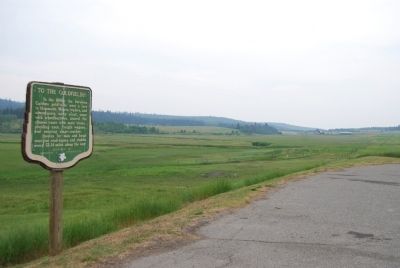
On Provincial Highway 97 23.3 kilometers south of 150 Mile House, on the right when traveling south.
In the 1860s, the fabulous Cariboo goldfields were a lure to thousands. Miners, traders, and adventurers, many afoot, some with wheelbarrows, shared the pioneer route with mule trains, plodding oxen, freight wagons, and swaying stage-coaches. . . . — — Map (db m8857) HM
English:
A search for the source of placer gold found on lower parts of the Fraser River led to discoveries of lode mines in the Cariboo, of which Williams Creek, is said to have yielded $19,000,000. As a centre of population in the . . . — — Map (db m42712) HM
On Barkerville Highway (Provincial Highway 26) 1 kilometer south of Reduction Road, on the left when traveling south.
This rare example of a 19th century Chinese benevolent society hall conformed to a Chee Kung Tong tradition that placed services to members on the ground floor and formal functions above. With its hostel, kitchen, and meeting and ceremonial spaces, . . . — — Map (db m42533) HM
This overshot water wheel is 16 feet in diameter. It is modeled after wheels and pumps used in the tin mines of Cornwall. The early miners found that the pay gravel often lay 40 to 100 feet under the surface. The wheels were used to pump the water . . . — — Map (db m42710) HM
Built in 1882, this is British Columbia’s oldest surviving courthouse, replacing one which stood here from 1862-1882. By 1918, declining population in Richfield led to the building’s closure. Designated a Provincial historic object in 1945, it was . . . — — Map (db m42763) HM
On Kwah Road West 0.3 kilometers west of Stewart Lake Highway (British Columbia Highway 27), on the right when traveling west.
English:
Simon Fraser and John Stuart established Fort St. James among the Carrier Indians in 1806. Originally a North West Company post, it passed to the Hudson’s Bay Company in 1821. From the beginning an important centre of trade and . . . — — Map (db m42736) HM
On Chilcotin-Bella Coola Highway (Provincial Highway 20) 8.2 kilometers east of Hanceville Cut Off Road, on the right when traveling east. Reported missing.
Norman Lee left his ranch in this valley in 1898 with 200 head on a 1500-mile "beef" drive to the Klondyke gold camps. Five months later, winter forced him to butcher the herd. He loaded the meat on scows, which were lost on Teslin Lake, 500 miles . . . — — Map (db m187944) HM
On Cariboo Highway (Provincial Highway 97) 1.1 kilometers south of Spur Road, on the right when traveling south.
Down river lay the perilous and unnavigable canyon. Up-river the Fraser was swift and strong, but sternwheelers could travel for 400 miles from Soda Creek. Men and supplies embarked here in the 1860's for the fabulous Cariboo goldfields. Later, as . . . — — Map (db m187977) HM
On Front Street (Provincial Highway 97) at Carson Street, on the left when traveling north on Front Street.
Promoted by Perry Collins, the U.S. Commercial Agent in Russia, and dependent on the Western Union Telegraph Company’s money, men and technology for its execution, this early telegraph line roused the enthusiasm of the white residents of . . . — — Map (db m276496) HM
For over half a century the Boyd family operated this haven for man and beast. Here weary travellers found lodging, food, and drink. Here fresh horses were hitched to stage-coaches and miners bought supplies.
This historic road-house, built in 1864 . . . — — Map (db m42766) HM
Near Cariboo Highway (Provincial Highway 97) 2.2 kilometers south of Unity Road, on the left when traveling south. Reported missing.
Plans to complete the Pacific Great Eastern Railroad to Prince George in 1921 failed because instable ground prevented use of the proposed bridge site on the Cottonwood River. Thus construction stopped at Quesnel. As northern expansion continued, . . . — — Map (db m188026) HM
On Nelson Nelway Highway (Provincial Highway 3A) 0.2 kilometers east of South Slocan Village Road, on the right when traveling east. Reported missing.
When hydro-electric power was first delivered from No. 1 plant to Rossland's mines in 1898, the 32-mile transmission lines were the longest on the continent. Utilizing the 360-foot drop from Kootenay Lake to the Columbia River, additional . . . — — Map (db m187946) HM
On Brilliant Road 0.5 kilometers east of Gorkoff Road, on the right when traveling east.
[English] This historic Bridge commemorates an achievement of the Doukhobors of Canada in establishing communal settlements in the Kootenay Boundary region of British Columbia during the early 20th century. Built in 1913 by community labour, . . . — — Map (db m197114) HM
On British Columbia 6 0.2 kilometers south of Crescent Valley Road, on the right when traveling south.
Sawmill pilings and a burner are the only reminders of the former Patrick Lumber Co., established in 1907. By 1911, the Patricks sold the mill to the British Canadian Lumber Corporation. Joseph and sons Frank and Lester risked the proceeds to . . . — — Map (db m187882) HM
On Highway 3A 0.3 kilometers south of View Road, on the right when traveling south.
It was the dream, in the 1880's of W.A. Baillie-Grohman, British sportsman and financier, to reclaim these fertile flats from the annual river floods. His canal at Canal Flats diverted part of the Kootenay into the Columbia but was abandoned. The . . . — — Map (db m188032) HM
On Broadway Street West at 3 Avenue NW, on the left when traveling west on Broadway Street West.
Modified greatly, this former Lodge's ice cream parlour was a structure that began as a
replacement for a former waterfront business operated on Bay street by
Amy & Ted Lodge. Evolved into a grocery store in the 1950's and a sporting goods
store . . . — — Map (db m303282) HM
On Broadway Street West at 4 Avenue NW, on the right when traveling west on Broadway Street West.
The construction of the new Masonic Block, the largest building in Nakusp at the time housed the Post Office (which had been on Bay Street) and the Bank of Commerce moved into the main floor of the new building. It holds a meeting room upstairs for . . . — — Map (db m303283) HM
On Broadway Street West at 5th Avenue NW, on the right when traveling west on Broadway Street West.
The courthouse formerly held a jail, forestry office and Provincial
Government office. It is recognized as the last building of its kind built in BC
and the only one still in use today. — — Map (db m303278) HM
On 5 Avenue Northwest at 1 Street NW, on the left when traveling north on 5 Avenue Northwest.
This Catholic Church was built entirely with donations from local people
and is the only original place of worship still used for that purpose in Nakusp.
In 1950, the rectory was added and in 1954 a new church entrance was built. — — Map (db m303280) HM
On Nelson Nelway Highway (Provincial Highway 3A) 0.2 kilometers west of Government Road, on the right when traveling west.
As this community prospered in the 1890s, tent hotels and log stores gave way to ornate edifices, and Nelson changed from a crude mining camp into the "Queen City of the Kootenays." The gully that divided Baker Street in two was bridged in 1890, . . . — — Map (db m187922) HM
On Vernon Street at Ward Street, on the right when traveling east on Vernon Street.
The 1902 opening of Nelson's new Dominion of Canada offices for postal, customs and inland revenue at 502 Vernon street was a huge step up from the tent that first housed Nelson's postal service. The building, constructed of Spokane brick and local . . . — — Map (db m197112) HM
On Eastman Avenue at Davis Street, on the left when traveling north on Eastman Avenue.
The orebody, known to Indians as
a source of lead for musket balls,
was staked in 1882 by Bob Sproule,
later restaked by Tom Hamill. The
resulting lawsuit cost Sproule
the property, and in revenge he
murdered his rival; was convicted
and . . . — — Map (db m187919) HM
On Crowsnest Highway (Provincial Highway 3) 3 kilometers south of Salmo Ski Hill Road, on the left when traveling south.
In the the early 1860s placer gold drew prospectors from all parts of the West to the Salmo River valley, and the Dewdney Trail from the west coast soon opened the region to increased travel. Development increased dramatically in 1893, when Daniel . . . — — Map (db m187931) HM
On Slocan Star Street 0.3 kilometers east of Sandon Road, on the left when traveling east.
Silver was the key that opened the Slocan. Discovery in 1891 of the rich outcrops of the "Slocan Star" and "Payne" touched off the wildest lode excitement in our history. The silver-lead ore was easily and cheaply mined, speeding development, and . . . — — Map (db m187952) HM
On Benvoulin Road 0.1 kilometers north of Casorso Road, on the right when traveling north. Reported missing.
Father Pandosy, an Oblate priest, ministered to natives and white in widely separated parts of British Columbia for over 30 years, until his death in 1891.
His mission, with its church, school and farms established in 1859-60 on this site, formed . . . — — Map (db m187909) HM
On Okanagan Highway (Provincial Highway 97) 0.2 kilometers south of Hardy Street, on the left when traveling south.
Directly across Lake Okanagan, on August 16, 2003, lightning struck a tree at Squally Point. The ensuing blaze consumed over 25,000 hectares as it spread to Kelowna, Myra Canyon, and Naramata. More than 33,000 people were evacuated and 238 homes . . . — — Map (db m187982) HM
Near Trans-Canada Highway (Provincial Highway 1) 0.8 kilometers north of Lybarger Road, on the right when traveling north.
[English] While exploring these mountains in the summer of 1865, Walter Moberly, assistant surveyor-general of British Columbia, noted the flight of eagles through a break in the Gold Range (Monashees), thereby discovering Eagle Pass. After . . . — — Map (db m198549) HM
Near Trans-Canada Highway (Provincial Highway 1) 0.8 kilometers north of Lybarger Road, on the right when traveling north.
A nebulous dream was a reality: an iron ribbon crossed Canada from sea to sea. Often following the footsteps of early explorers, nearly 3000 miles of steel rail pushed across vast prairies, cleft lofty mountain passes, twisted through canyons, and . . . — — Map (db m187955) HM
Near Trans Canada Highway (Route 1) west of Whispering Wood Lane.
[English]
Baldwin #7717 Steam Locomotive
This Baldwin 2-6-0 mogul steam engine – builders #7717 – road #6 – 36" gauge locomotive, was built for the North Western Coal & Navigation Co. in 1885. It was originally used . . . — — Map (db m44339) HM
Canadian Pacific Railway Log Houses
circa 1928
These log homes were built for Canadian Pacific Railways officials. A closer look at the houses reveals a unique form of saddle-notch construction. Wood for these homes . . . — — Map (db m251343) HM
On Transcanada Highway (National Route 1), on the right when traveling west.
First recorded in the report of the Palliser expedition of 1857-60, this pass takes its name from an incident in which Dr. James Hector, surgeon in the expedition, was kicked by his horse while exploring in this vicinity. The pass was . . . — — Map (db m74545) HM
Near Trans-Canada Highway (Provincial Highway 1) at Field Access Road.
[English] Take a look across the river. A century ago, an elegant hotel dominated this view. Now just a memory, Mount Stephen House was the first in a series of “Grand Hotels” built by the Canadian Pacific Railway. The CPR . . . — — Map (db m203580) HM
Near Trans-Canada Highway (Provincial Highway 1) at Field Access Road.
[English] In 1901, Mount Stephen Reserve was enlarged and became Yoho Park Reserve. The following year, Mount Stephen House was also expanded and now featured a rotunda, a huge dining room, a theatre and 60 rooms. Word got out . . . — — Map (db m203581) HM
Near Trans-Canada Highway (Provincial Highway 1) at Field Access Road.
[English] It was not my intention to have passed any great time at Field, yet I was detained there by the force of its attraction… the views from Field are fine and the excursions that can be made in the neighbourhood are . . . — — Map (db m203582) HM
On 1st Avenue at East First Street, on the left when traveling south on 1st Avenue.
St Joseph Roman Catholic Church
For over 100 years, St. Joseph's has served the community of Field. Mass is still held here during the summer, and the original church bell tolls on special occasions. Prior to the 1950's, the . . . — — Map (db m303273) HM
Covered bridges are very popular as historical landmarks, tourist attractions, and romantic links to a by-gone era. There are literally dozens of organizations dedicated to their preservation, education, and promotion. Yet despite their unique . . . — — Map (db m313492) HM
Near Golden View Road 0.2 kilometers south of Lafontaine Road, on the right when traveling south.
The first Sikhs arrived in Golden in 1902 to work in the mill of the Columbia River Lumber Company. Their Gurdwara (temple), one of the earliest in BC, became a focus of cultural identity and religious ceremony for the Sikh community.
Their . . . — — Map (db m188006) HM
Near 10th Avenue South (Provincial Highway 95) at 11 Avenue South, on the right when traveling north.
With the completion of the railway in 1885 the Canadian Pacific Railway recognised that many travellers through Golden would want to stay and discover this incredible area for themselves. To this end, the CPR hired professional Swiss mountain . . . — — Map (db m313481) HM
Near Trans-Canada Highway (Provincial Highway 1) 11.5 kilometers east of Provincial Highway 95, on the left when traveling east.
Naming the Kicking Horse In the mid-1850s, an expedition was sent out by the Imperial Government to locate a feasible route west through the Canadian Rockies that would give good access to settlers in search of rich farming soil and . . . — — Map (db m203579) HM
Near 11 Avenue South at 14 Street South, on the right when traveling north.
The far upper Columbia River’s steamboat era lasted only twenty-eight years, from 1886 to 1914. It concerned two streams. It ranged from Golden on the Columbia River up to Columbia Lake across Canal Flats and down the Kootenay River to Jennings, . . . — — Map (db m313367) HM
On 10th Avenue South (Provincial Highway 95) at Park Drive, on the right when traveling north on 10th Avenue South.
Rivers The Kicking Horse River is one of the wildest, most intense recreational waterways in Canada. Dropping from Wapta Lake and joined by the Yoho, Emerald, Amiskwi and Ottertail Rivers, the Kicking Horse flows wild and free, unobstructed . . . — — Map (db m313483) HM
On 10th Avenue South (Provincial Highway 95) at 9 Street South, on the right when traveling south on 10th Avenue South.
Golden, BC is surrounded by vast expanses of ski terrain and virgin snow and is a paradise for the serious skier who is searching for the best mountains in Canada, champagne powder and every conceivable type of terrain and exposure. Heli-skiing . . . — — Map (db m313485) HM
On 1 Street West at Boyle Avenue, on the right when traveling east on 1 Street West.
When Prime Minister Sir Wilfrid Laurier visited Revelstoke in 1910 he chose the site of this heritage building, to solve a citizens' dispute over a central
location for the Post Office. Construction, however, did not commence until 1925. The . . . — — Map (db m303275) HM
Near Big Bend Highway (Provincial Highway 23) 2.6 kilometers north of Pearkes Drive, on the left when traveling north.
For 1200 miles, in two countries, the Columbia carves its way to the Pacific Ocean. Named after Robert Gray's ship the "Columbia", it was first mapped in 1811 by David Thompson. This "highway" for traders, missionaries and gold miners later became a . . . — — Map (db m187966) HM
On 2 Street West west of Garden Avenue, on the left when traveling west.
Built in 1896, St. Peter's is Revelstoke's only surviving pioneer church. It and the brick rectory beside it stand much as
they were at the turn of the century. The Hall was added in
1931. Anglican services in Revelstoke date from April 1885 . . . — — Map (db m303276) HM
Near Trans-Canada Highway (Provincial Highway 1) 85 kilometers west of Provincial Highway 95.
A ninety room hotel complete with bowling alley and observation tower once stood in this quiet clearing!Operated by the Canadian Pacific Railway from 1887 to 1925, it was used as a base by mountaineers, adventurers and sightseers from all over the . . . — — Map (db m108665) HM
On Trans-Canada Highway (Provincial Highway 1), on the right when traveling east.
For many years steam locomotives on the mainline of the Canadian Pacific Railway rumbled across these stone pillars.
Construction of the railway through these rugged mountains was a constant struggle. In this area, steep-sided valleys and . . . — — Map (db m110556) HM
On Kootenay Highway (Provincial Highway 93/95) 1.3 kilometers north of Burns Avenue, on the left when traveling north.
In 1808 David Thompson named this flat “McGillivary's Portage” as he crossed from Columbia Lake to the Kootenay River. In 1889 W.A. Baillie-Grohman joined the two waterways by a canal with a single lock. Regulations aimed at preventing Columbia . . . — — Map (db m188022) HM
On Van Horne Street South (Provincial Highway 3) south of 5th Avenue South, on the right when traveling south.
The Canadian Pacific Railway helped open up south-east British Columbia with a strategic line through the Rocky Mountain Crowsnest Pass. It also helped maintain Canadian sovereignty over Kootenay mineral wealth which had been flowing south to . . . — — Map (db m187918) HM
Canada's National Poultry Breed
Created by a monk named M. Wilfred Chatelaine (1876-1963) in the Province of Quebec in 1919. The Chantecler chicken was bred to be a 'dual-purpose' breed, meaning they provided good meat and good egg . . . — — Map (db m303271) HM
On Wardner Fort Steele Road, on the right when traveling east.
The 1864 gold rush at Wild Horse Creek created
the town of Fisherville, named after Jack Fisher,
prospector. Located approximately 6 kms. up
Ft. Steele Wildhorse Road, it briefly flourished
as a home for hundreds of gold-hungry miners.
When . . . — — Map (db m288764) HM
On Provincial Highway 93/95 close to St. Mary's Street.
Gold miners poured into this area in the 1860’s crossing the Kootenay River at the foot of this street. The settlement that grew up here was first called Galbraith’s Ferry.
In 1887 the N.W.M.P. established a post here when friction developed . . . — — Map (db m100115) HM
On Wardner Fort Steele Road, on the right when traveling east.
In 1864, whispers of "Kootenay Gold" circulated along the Pacific Slope, drawing prospectors from across the West to an area known as... — — Map (db m288765) HM
On Kootenay Highway (Provincial Highway 3) 0.8 kilometers east of Ha Ha Creek Road, on the left when traveling south.
A colourful steamboat era preceded the railways. During mining boom days of 1893-98 a fleet of sternwheelers ran north from the railway at Jennings, Mont., to Ft. Steele and vicinity.
Carrying prospectors, freight, and ore they battled . . . — — Map (db m187987) HM
On Crowsnest Highway (Provincial Highway 3/95) 0.4 kilometers south of Half Moon Avenue, on the right when traveling south.
Kootenay gold discoveries attracted thousands of prospectors from Washington Territory in the late 1850s and 1860s. In those years all trails led south into Washington and Idaho and the vast bulk of the treasure and commerce enriched those regions. . . . — — Map (db m187913) HM
On Crowsnest Highway (Provincial Highway 3/95) 0.3 kilometers south of Half Moon Avenue, on the right when traveling south.
In 1893 a Kootenay Indian, Pierre, found a rich galena outcrop in the hills nearby. Father Coccola of St. Eugene Mission arranged sale of the claims, and with the proceeds built a new home for Pierre and a new mission church. Development of the . . . — — Map (db m187928) HM
On Kootenay Highway (Provincial Highway 93) 2.2 kilometers south of Stanley Street, on the right when traveling south.
In 1841, Sinclair guided 200 Red River settlers from Fort Garry through the Rockies to Oregon in an attempt to hold the territory for Great Britain. By 1854 he had recrossed the mountains several times by routes which later were followed by trails . . . — — Map (db m187991) HM
On Crowsnest Highway (Provincial Highway 3) just north of British Columbia-Alberta boundary line, on the left when traveling west.
Rivers born in Canada's Rockies carved passes eastward to Hudson Bay or westward to the Pacific. This one was long used by Indians, but not shown on maps until the Palliser Expedition of 1860, and then only from hearsay. Michael Phillipps blazed a . . . — — Map (db m288767) HM
On Crowsnest Highway (Provincial Highway 3) 3.3 kilometers south of Douglas Fir Road, on the right when traveling south.
Dr. Dawson was one of the most renowned of the early mapmakers of the Pacific Slope. In 1883 Dr. Dawson explored the Crow's Nest Pass for the Geological Survey of Canada. His report demonstrated his extraordinary ability to provide not only . . . — — Map (db m187904) HM
On Crowsnest Highway (Provincial Highway 3) 0.4 kilometers west of Elk Valley Coal Road, on the right when traveling west.
Gone but still remembered — no formal boundaries
divided the communities of Natal, Michel and Middletown —
“home” to thousands of coal miners for generations. Workers
came from many parts of Europe and North America to toil
in these mines. . . . — — Map (db m187935) HM
On Kootenay Highway (Provincial Highway 93) 0.7 kilometers south of Simpson River Trailhead, on the right when traveling north.
[English] Born in the Scottish Highlands, Simpson joined the Hudson's Bay Company in 1820. In 1821 he became governor of the Northern Department, and in 1826 governor-in-chief in Rupert's Land. An energetic administrator with a . . . — — Map (db m201674) HM
On Banff-Windermere Highway (Provincial Highway 93), on the right when traveling north.
The four Rocky Mountain national parks of Banff, Jasper, Kootenay and Yoho share boundaries, scenery, geology, plant and animal life, human history and importance to the world. These four parks were declared a World Heritage Site in 1985 by the . . . — — Map (db m312999) HM
On Banff-Windermere Highway (Provincial Highway 93), on the right when traveling north.
[English] “Between the International Boundary and the 120th degree of longitude, the Inter-provincial Boundary is the line dividing the waters flowing into the Pacific Ocean from those flowing elsewhere.” . . . — — Map (db m312997) HM
On Banff-Windermere Highway (Provincial Highway 93), on the right when traveling north.
[English] “Of all the passes traversed by our expedition the most favourable and inexpensive to render available for wheeled conveyances would be Vermilion Pass, as the ascent to the height of land is the most . . . — — Map (db m312996) HM
On Laurier Street 0.2 kilometers south of Daly Street, on the left when traveling south.
Timber in abundance, woodsmen ready to work, a river to float logs, and a railway to transport products: ingredients critical to the emergence of early twentieth century mills in the Kootenay River basin. The Crows Nest Pass Lumber Company at . . . — — Map (db m187939) HM
A reserve on the St. Mary's River was laid out for the Kootenay
Indians in 1884, but as the district's ranching potential became
known, investors pre-empted meadows traditionally used by the
Indians. The Indians made counter claims and . . . — — Map (db m303270) HM
On Southern Yellowhead Highway (Provincial Highway 5) 2.4 kilometers south of Bear Road, on the left when traveling south.
On Nov. 21, 1950, a westbound
train carrying Canadian troops
en route to the Korean War
collided with an eastbound train
near Canoe River, killing 21
people. A telegraph operator
was charged with manslaughter
for the miscommunication and
was . . . — — Map (db m187887) HM
Near Yellowhead Highway (Provincial Highway 16) at British Columbia-Alberta boundary line, on the right when traveling west.
Named after “Tete Jaune”, blond fur trader at Jasper House, this low pass was favoured by Sandford Fleming in his railway surveys of the 1870's. Rejected by the C.P.R., the route was later used by the Grand Trunk Pacific and the Canadian Northern . . . — — Map (db m187943) HM
On Yellowhead Highway (Provincial Highway 16) 24.8 kilometers west of Icefields Parkway (Provincial Highway 93), on the right when traveling west.
[English] In 1971, the Government of Canada recognized the national historical significance of several western mountain passes, including the Yellowhead Pass. These passes played an important role in opening up . . . — — Map (db m311998) HM
On Yellowhead Highway (Provincial Highway 16) 24.8 kilometers west of Icefields Parkway (Provincial Highway 93), on the right when traveling west.
[English] Yellowhead Pass National Historic Site straddles the Alberta-British Columbia border, stretching from the outskirts of the town of Jasper to the Fraser River crossing in Mount Robson Provincial Park. . . . — — Map (db m311696) HM
On Yellowhead Highway (Provincial Highway 16) 24.8 kilometers west of Icefields Parkway (Provincial Highway 93), on the right when traveling west.
This historic pass gets its name from a famous fur trader that worked here during the early part of the 19th century. “Tête Jaune” was the nickname of Pierre Bostonais, a fair haired Iroquois trader who was employed by the North West and Hudson's . . . — — Map (db m311999) HM
On Yellowhead Highway (Provincial Highway 16) 24.8 kilometers west of Icefields Parkway (Provincial Highway 93), on the right when traveling west.
[English] In the early 1920s, portions of the abandoned rail line through Yellowhead Pass became a rough trail for adventurous automobile travellers. Formal road construction did not begin until the 1940s. During the . . . — — Map (db m311996) HM
On Yellowhead Highway (Provincial Highway 16) 24.8 kilometers west of Icefields Parkway (Provincial Highway 93), on the right when traveling west.
[English] Yellowhead Pass, with its low elevation and gentle grade, seemed like a good choice when surveyors were looking for a route to connect British North America from coast to coast via a transcontinental . . . — — Map (db m311694) HM
On Yellowhead Highway (Provincial Highway 16) 24.8 kilometers west of Icefields Parkway (Provincial Highway 93), on the right when traveling west.
[English] This pass was used for brief periods from the mid-1820s to the early 1850s by the Hudson's Bay Company, principally to transport leather, especially moosehides, from the Saskatchewan District to its posts in New Caledonia. . . . — — Map (db m202600) HM
On Yellowhead Highway (Provincial Highway 16) 24.8 kilometers west of Icefields Parkway (Provincial Highway 93), on the right when traveling west.
[English] For thousands of years and long before it was named Yellowhead, this low pass was used by indigenous peoples. For Aboriginal people this corridor was an important travel and trade link, . . . — — Map (db m311697) HM
On Yellowhead Highway (Provincial Highway 16) 24.8 kilometers west of Icefields Parkway (Provincial Highway 93), on the right when traveling west.
[English] For centuries, Yellowhead Pass has been a travel route connecting people, places and wildlife. Human use of the pass spans from its early days as a passage for Aboriginal trade and travel, to its current . . . — — Map (db m311695) HM
Near Viewpoint Road 0.2 kilometers east of Kinney Lake Road, on the left when traveling east.
In 1942, over 21,000 Japanese Canadians were unjustifiably removed from British Columbia's coast. Despite their protests many men aged 19 to 60+ were torn from their families and sent to road camps like Red Pass. Internees gave 290,238 man-days of . . . — — Map (db m187875) HM
On Caine Drive, on the right when traveling north.
Simon Fraser's men cut the first spruce logs near the junction of the Nechako and Fraser Rivers in 1807 to construct Fort George. Starting near the original fort a century later, Prince George became in the 1940's the centre of the white spruce . . . — — Map (db m187962) HM
On Crowsnest Highway (Provincial Highway 3) at Boundary Smelter Road, on the right when traveling east on Crowsnest Highway.
Although prospectors like "Jolly Jack” Thorton worked this area during the 1860s, Boundary Falls was not settled until the 1890s, when a new breed of miners flooded the district. Surrounded by mining properties, the Boundary Falls Smelter (also . . . — — Map (db m187917) HM
On British Columbia 395 0.1 kilometers east of Crowsnest Highway (Provincial Highway 3), on the left when traveling east.
Cascade came into being during the late-1890s as a bustling railway construction town claiming 17 hotels at its height. Its location along the Canada-U.S. border proved strategic for mining, freighting, and hydro-electricity. The early development . . . — — Map (db m187915) HM
On Crowsnest Highway (Provincial Highway 3) 2 kilometers west of Wilgas Lake Rest Area, on the left when traveling west.
In 1900, the CPR's Columbia & Western Railway penetrated the formidable mountains between Nelson and Midway, connecting the Boundary district to East Kootenay coalfields and beyond. Eholt, at the summit between Grand Forks and Greenwood, became the . . . — — Map (db m187908) HM
On Crowsnest Highway (Provincial Highway 3) 3.4 kilometers west of Stewart Creek Road, on the left when traveling west.
Doukhobors arrived in the Kootenay Boundary area in 1908. Persecuted in Russia for rejecting church rituals and military service, they were derisively named Doukhobors, or ‘Spirit Wrestlers’. Finding refuge in Canada, these Christian pacifists . . . — — Map (db m187884) HM
On Smelter Viewpoint at Butte Avenue, on the right when traveling south on Smelter Viewpoint.
During the prosperous years of the late 1890s, this street was one of the busiest thoroughfares in the province. Little wonder, for in those years copper was king, and Greenwood — incorporated as a city in 1897 — was the capital of the copper-rich . . . — — Map (db m187914) HM
On Smelter Viewpoint at Butte Avenue, on the left when traveling north on Smelter Viewpoint.
In this wilderness of rugged mountains, ore was first found in the late 1880's. Further prospects led to the building of a large smelter by the B.C. Copper Co. From 1901, copper, gold and silver poured from its furnaces. Fed by the great Motherlode . . . — — Map (db m187998) HM
On Crowsnest Highway (Provincial Highway 3) just west of Beamish Street, on the right when traveling west. Reported permanently removed.
When the Midway to Hope section of the “K.V.” was completed in 1916 and joined with existing short lines, it formed a direct southern railroad from Alberta to the Pacific Coast. An important factor in advancing the economy of southern B.C., it has . . . — — Map (db m187941) HM
On 5th Avenue at Florence Street, on the right when traveling east on 5th Avenue.
Proximity to Boundary Creek mines, and excellent climate, water and soil convinced Midway promoters of a bright future as a "railway and residential town.” The Columbia & Western Railway reached Midway in 1900; five years later, the Vancouver, . . . — — Map (db m187938) HM
On BC-3B (Provincial Highway 3B) at Paterson-Trail Highway (Provincial Highway 22), on the right when traveling west on BC-3B.
You have entered the crater of an ancient volcano rich in minerals. The waste dumps are the remains of famous Rossland mines staked in 1890 by prospectors passing on the near-by Dewdney Trail. From these fabulously rich workings came 6,000,000 tons . . . — — Map (db m187953) HM
Near Paterson-Trail Highway (Provincial Highway 22) 1.1 kilometers north of King George Park Road, on the right when traveling west.
"A travel route north of the boundary line" was the cry in the 1860's when gold was found in the Kootenays. Edgar Dewdney built such a route — a trail 360 miles long from Coast to Rockies.
For over two decades it carried miners, settlers, gold . . . — — Map (db m187959) HM
On Okanagan Highway (Provincial Highway 97) 0.3 kilometers east of St. Annies Road, on the left when traveling south.
One of the earliest cattle empires in the Okanagan began in 1867 when Cornelius O'Keefe and Thomas Greenhow drove cattle from Oregon to the north end of Okanagan Lake. In 1868 O'Keefe homesteaded 162 acres nearby, and within 40 years his cattle . . . — — Map (db m187981) HM
On Vernon-Sicamous Highway (Provincial Highway 97A) just west of Creamery Road, on the left when traveling west.
“And our eyes feasted on the
long stretch of prairies…” wrote
A. L. Fortune, first settler in
this fertile valley, in June, 1866.
The natural meadows, rippling in
tall grasses, were ideal pasture
for cattle and sheep. Later, grain
replaced . . . — — Map (db m187929) HM
On Kalamalka Lakeview Drive 0.3 kilometers south of Okanagan Highway (Provincial Highway 97), on the left when traveling south.
The valley's potential was seen by Forbes and Charles Vernon in 1863, when travelling to silver claim staking 40 miles to the east. In 1864, the brothers pre-empted across the lake 1000 fertile acres which became Coldstream Ranch. Its products . . . — — Map (db m188020) HM
On Okanagan Highway east of The Hook, on the right when traveling east.
Trumpets first sounded here in 1908 calling the Okanagan's cavalry to muster. Joined by infantry battalions, thousands of militiamen and cadets from all over the province came to know Mission Hill as British Columbia's largest military camp. . . . — — Map (db m187949) HM
On Crowsnest Highway (Provincial Highway 3) 1.9 kilometers north of Barcello Road, on the left when traveling north.
For many thousands of years S ukwnaqinx (later Anglicized to "Okanagan") travelled and peopled a far-reaching territory. Though their main camp was centred at Penticton, this valley was used as a food gathering base-camp. . . . — — Map (db m187910) HM
On Daly Avenue north of Haynes Street, on the left when traveling north.
From the heart of this mountain, men took $47,000,000 in gold. It started in 1904 when Hedley boomed with the opening of the mill in town and the Nickel Plate Mine on the mountain-top. The nearby Hedley Mascot Mine, on a claim of less than an acre, . . . — — Map (db m188007) HM
On Crowsnest Highway (Provincial Highway 3) 1.1 kilometers west of Ashnola Road, on the left when traveling west.
This old covered bridge and parts of the abandoned right-of-way are mute reminders of the Vancouver, Victoria und Eastern Railway (VVAE), a subsidiary of the American-based Great Northern Railway. Between 1907 and 1914, the VVAE pushed northward, . . . — — Map (db m187920) HM
On Fairview Road 0.2 kilometers east of Willowbrook Road, on the right when traveling east.
The 1890's held high hopes for the lode gold of mines such as Stemwinder, Morning Star, and Rattler. By 1902, when the Fairview Hotel or "Big Teepee" burned, the golden years were over. Fairview's population dwindled as miners left for more . . . — — Map (db m188011) HM
On Crowsnest Highway (Provincial Highway 3) 0.2 kilometers west of Observatory Road, on the right when traveling west.
A valley north and south, a sandspit east and west — this was the crossroad of the centuries. Down the valley on Indian trails came the laden horses of the Fur Brigade from 1824 to 1848. Later, miners and settlers streamed northward. Across the . . . — — Map (db m187930) HM
On Crowsnest Highway (Provincial Highway 3) at Kobau Look-Out Forest Service Road, on the right when traveling south on Crowsnest Highway.
The Okanagan nation knows Spotted Lake, just east of here, as K t li lxw. From time immemorial its healing waters and mud were used by First Nations to cure aches and illness, and for spiritual healing. High concentrations of Epsom . . . — — Map (db m187927) HM
On Bridgeman Road 0.3 kilometers east of Okanagan Highway (Provincial Highway 97), on the right when traveling north.
When John M. Robinson, a former Manitoba legislator and newspaper editor, came to the South Okanagan in 1898, he found only dry grazing land. Seeing its potential, he introduced irrigation and led in the establishment of peach, pear, apricot, and . . . — — Map (db m187988) HM
On Trans-Canada Highway (Provincial Highway 1) 0.3 kilometers south of Cornwall Road, on the left when traveling south.
In 1862 C.F. and H.P. Cornwall settled here and developed Ashcroft Manor. The ranch, with its grist and saw mills, supplied Cariboo miners. The manor house was destroyed by fire in 1943, but the road house survives. Clement Cornwall became one of . . . — — Map (db m187921) HM
109 entries matched your criteria. The first 100 are listed above. The final 9 ⊳