In 1791 James Wilson in partnership with Richard Beasley built a sawmill and a grist-mill on the site of this community. The mills were sold to Jean Baptiste Rousseaux (known as St. John) in 1794 and developed into a thriving pioneer enterprise. . . . — — Map (db m220193) HM
Sir John Morison Gibson
1842-1929
Lawyer, politician, and businessman, John Gibson was a tireless proponent of the economic advancement of Hamilton. Gibson's Hamilton-focused business interests
encompassed real estate development, . . . — — Map (db m227476) HM
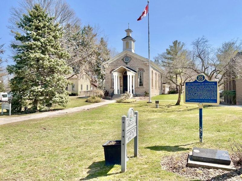
William Terryberry
(1779-1847)
Since 1812, the name William Tenybeny has been associated with this section of Mohawk Road West. Having immigrated to the province of Upper Canada from the state of New Jersey, Terryberry purchased land along . . . — — Map (db m232325) HM
By 1799 the Morden family had a sawmill near this site
on Spencer Creek north of Dundas Street. They sold this
property in 1800 to Edward Peer who built a grist-mill
about 300 yards south-east, close to Dundas Street, and
adopted the name . . . — — Map (db m220819) HM
Peter Desjardins made it his life's work to develop viable canal route from Lake Ontario to Dundas
Desjardins came to Canada from France in 1792. He settled in Dundas in 1805 where he became Richard Hatt's chief clerk, Hatt envisioned a . . . — — Map (db m226479) HM
The province's first paper mill began operations in 1826.
Situated about 150 yards downstream from here, it was owned by James Crooks (1778-1860), one of Upper Canada's most successful entrepreneurs. On four hundred acres of land purchased here . . . — — Map (db m223079) HM
In the early 1800s, city promoters campaigned vigorously to bring a railway to Hamilton. In 1849, local industry and municipal government backed the construction of the Great Western Railway (GWR).
The first train left Hamilton on November . . . — — Map (db m235062) HM
1887 1987 2087
Engineering Centennial Commemorative Plaque and Time Capsule
This monument has been erected by the Hamilton Section of
the Canadian Society for Civil Engineering on behalf of all individuals and organizations . . . — — Map (db m235468) HM
This land was occupied by various indigenous groups, including the Chonnonton Nation, meaning people who tend deer'. They were known by their neighbours as the 'Attiuoindaron' and by the French as the Neutrals.
United Empire Loyalist Colonel . . . — — Map (db m220755) HM
The Burlington Glass Works, formerly situated here, was one of the most important 19th century glass houses in Canada in terms of the variety and quality of its production. From 1874 to about 1897 skilled artisans produced lamps, tablewares and . . . — — Map (db m220301) HM
The Hamilton Waterworks
This dignified building, reminiscent of the style of a Roman aqueduct, houses one of Canada's greatest surviving engineering achievements of the mid-19th century, the Hamilton Waterworks. Built between 1857 . . . — — Map (db m227140) HM
By 1850, a four storey building called the Mountain View Hotel was erected on this site. Its proximity to the escarpment's edge provided an unobstructed view of the city, harbour and lake. Two hundred pine steps at the base of the escarpment . . . — — Map (db m226084) HM
The Honourable Isaac Buchanan and Auchmar
Isaac Buchanan was born in 1810 in Glasgow into a family that owned the Auchmar estate on the shores of Loch Lomond. At the age of 19 he was sent to Montreal to open a branch of an importing firm. . . . — — Map (db m225887) HM
Quick Facts: Two hotels patronized by users of Crystal Palace and Victoria Park
The opening of the Crystal Palace on the Victoria Park grounds in 1860 inspired West End population growth and the creation of new businesses. Two hotels were . . . — — Map (db m229384) HM
Quick Facts: Site of 1860, 1864, 1872 Provincial Expositions - Queen Victoria's Jubilee
Built in 1860 to host the Provincial Exposition, the Crystal Palace was constructed on a 22 acre site as a modern facility capable of hosting the fair. The . . . — — Map (db m228564) HM
Quick Facts: Family business 1875-1963 - George R. Allan School, Westdale testing grounds
The name "Hand" is synonymous with fireworks in Canada and
North America. In 1872 William Hand arrived in Newark, New
Jersey from Hereford, England. . . . — — Map (db m229623) HM
Quick Facts: Family business started in 1868 - Employed 100 - Demolished in 1972
In 1868, Semmens and Sons was a family-owned building firm, located on the east side of Sophia Street (Strathcona Avenue North), north of Florence Street. By . . . — — Map (db m229476) HM
John William Kerr emigrated from Ireland to Canada in the 1840s and settled a crown grant on the Hamilton Mountain in the 1850s. Kerr was made the first provincial fisheries overseer by royal warrant in 1864. From a telescope on the escarpment . . . — — Map (db m223692) HM
Goderich
Founded 1827 • Dedicated • Incorporated 1850
May 1, 2010
The Goderich Dominion Post Office and Customs Office was built in 1889-1890. The imposing grey stone Romanesque Revival building was designed by Thomas Fuller, Chief . . . — — Map (db m192987) HM
In 1923, a garage was built here and an automobile sales and service was operated by "Dryden District Motors", "Dryden Motors", and "Dryden Service" respectively. Vernon Pronger rebuilt the building in 1938, and operated "Vernon's Grocery" here for . . . — — Map (db m243107) HM
Born in Reston, Manitoba Sept. 20, 1920 and brought up in Treherne, Manitoba, Grant had a happy, busy childhood. When WWII started, Grant volunteered with the Air Force, serving in North Africa and England. He was on his way to the Pacific when the . . . — — Map (db m243231) HM
Alan Durance left behind a legacy of accomplishments the likes of which most people only dream. It all began in 1919 at age 17 when he arrived from England with his parents and siblings and settled on a homestead farm two miles north of Dryden. . . . — — Map (db m243095) HM
Alex Wilson was a visionary and a man of many talents and accomplishments. He came to Canada with his Scottish parents at age eight. With a grade nine formal education, he began a life-long period of learning in the real world of the world's worst . . . — — Map (db m243269) HM
The west shore of the river is about where nature made it. There was a waterfall where the dam and Duke Street Bridge are now, and an island at the east end of the present bridge. A second channel, also with a waterfall about where you are . . . — — Map (db m242997) HM
Before World War II, most of the wood supply for the mill as well as the several saw mills which operated in Dryden was delivered by water. The wood was cut generally in the winter around the hundreds of miles of shore line of Lake Wabigoon and its . . . — — Map (db m242994) HM
Dryden has been a center of the forest industry for over a century due to the availability of timber, its location on the Canadian Pacific Railroad and, before the existence of the power grid, the potential for power generation by the Wabigoon . . . — — Map (db m243085) HM
In 1940, at the age of 21 years, Russell left Dryden to escape the great depression, and to join the Royal Canadian Regiment at London, Ontario. In 1943 he left the peaceful hills of England to land in Sicily as part of the British Army. When . . . — — Map (db m243258) HM
Farmer, bush camp foreman, tugboat operator, retail lumberman, husband and father, fisherman, hunter, town councillor, mayor. George Rowat was part of a generation who started life in an era of great potential and who worked hard to build their . . . — — Map (db m243094) HM
About 1885 gold was discovered at Goldrock on the northern tip of Upper Manitou Lake about 30 miles southeast of here. A townsite was laid out in 1898 which grew to a town of 500 by its peak in 1908. At that time there were 5 gold mines operating . . . — — Map (db m243000) HM
Built in 1897 by J. S. McFadyenMr. McFadyen built several of the town’s early buildings including the first jail & council chamber in 1904. — — Map (db m243242) HM
In the early 1900’s the best and strongest wrapping paper was made from Jack Pine using the Kraft process. The process used then required quantities of soap stone, and there are a number of soap stone mines in the Dryden area. The principal forest . . . — — Map (db m242993) HM
For 20 years Dryden turned its back on its waterfront, and the river no longer played a central role in the lives of the town. The wood disappeared from the river, and the paper mill retreated from the waters edge. The dilapidated boathouses . . . — — Map (db m242996) HM
This building was built in 1911 by postmistress, Mrs. Ida Smith. With Ida's death in 1921, her daughter Aldra became owner and postmistress. In 1926, Mr. John Harris became owner and postmaster. The post office was moved in 1939. Mr. & Mrs. . . . — — Map (db m243297) HM
Dedicated in memory of William Jennings (Bill) Silver A papermaker of forty-eight years and husband of Edna Lillian Silver (nee Neely), Bill was a gentle and upright man who loved and supported his family and his community. The Silver family was . . . — — Map (db m243293) HM
Logging operations began locally in 1879 when demand for ties and lumber came with the construction of the Canadian Pacific Railway in the area. As many as seven mills operated along the Rat Portage-Keewatin shore lines at one time employing 400 to . . . — — Map (db m245199) HM
This mural was one of the first to be sponsored by a local businessman, the owner of this hotel. It shows a gentleman’s bar at the turn of the century, with woodcarving, elaborate glassware & formally dressed bartenders. Two players enjoy a card . . . — — Map (db m245377) HM
This was early frontier Kenora/Keewatin, and was named by the Ojibway people for the many muskrats inhabiting these waters. Venturing into this area were a number of fur traders employed by the Northwest Company and the Hudson’s Bay Company. They . . . — — Map (db m244996) HM
On Old Fort Island a half mile north of here, the Hudson's Bay Company erected a stockaded fur trading post about 1836. This was the first known European structure within present Kenora. In 1861 the post was moved to the mainland, where it formed . . . — — Map (db m106495) HM
Created by Mike Svob of Coquitlam, British Columbia, the mural depicts the symbol of Canadian unification after confederation. The Canadian Pacific Railroad which was called “The National Dream” enabled all Canadians to travel from coast to coast . . . — — Map (db m245334) HM
The full name given in the charter is: “The Governor and Company of Adventurers of England, Trading into Hudson Bay”. The charter, granted by King Charles on May 2nd, 1670, gave the company “The Whole Trade of All Those Seas, Streights, and Bays, . . . — — Map (db m244997) HM
Who Was James McMillan?The namesake of the James McMillan tug boat — Mr. James A. McMillan — was a popular logging superintendent with the Ontario-Minnesota Pulp and Paper Company who died unexpectedly in 1942. McMillan was well . . . — — Map (db m245200) HM
Created by Joyce Kamikura of Richmond, British Columbia, the painting features one of the major boat manufacturing companies on the Lake of the Woods and was a landmark on the Kenora waterfront until the late 1960’s. The Clipper was powered by a . . . — — Map (db m245233) HM
Main Street, Rat Portage in 1870 was little more than a collection of buildings on the edge of the Lake. Frank Gardner's business establishment is clearly identified; a pioneer who was active for a further 65 years. Lower photo, taken in 1880 . . . — — Map (db m245198) HM
We are standing on a section of Queen Street that has a long history of civilian uses for housing, in close proximity to important military facilities. An early town graveyard still exists up the street next to St. Paul's Church.
The site is on . . . — — Map (db m144972) HM
English:
Early in his celebrated career the explorer La Salle played a principal role in the expansion of the French fur trade into the Lake Ontario region. In 1673 he arranged a meeting between Governor-General Frontenac, who . . . — — Map (db m141300) HM
English
The presence of oil in this locality was observed by early travelers and by the pioneer farmers who used it for medical purposes. In 1858, near Oil Springs, James M. Williams dug the first oil well in Canada and later established a . . . — — Map (db m78424) HM
Following the discovery of oil at Oil Springs in 1857 prospectors extended their search to the entire township of Enniskillen. At the site of Petrolia, which contained two small settlements with post offices named Durance and Ennis, a well was . . . — — Map (db m78417) HM
The sawmill and grist-mill completed here on the Mississippi River in 1823 by Daniel Shipman provided the nucleus around which a community known as Shipman's Mills had developed by 1824. About 1850 two town plots were laid out here - "Victoria" by . . . — — Map (db m104000) HM
In 1857 James Rosamond built this mill on the Mississippi River, thereby firmly establishing the woollen industry in Almonte. An Irish-born entrepreneur, Rosamond was previously a resident of nearby Carleton Place where, in 1846, he had built one . . . — — Map (db m104009) HM
Scottish born David Findlay arrived in Canada in 1858 and settled in Perth, Ontario. Finding little opportunity for working at his trade as a moulder, he left two years later for
Carleton Place. Walking the 21 miles with only $30 in . . . — — Map (db m234402) HM
The families of Edmond Morphy and William Moore became in 1819 the first settlers on the site of Carleton Place. About 1822 Hugh Boulton built a mill here on the Mississippi River which provided the nucleus around which a community, known as . . . — — Map (db m103985) HM
This grand stone hotel at 7 Bridge Street was built on land originally deeded in 1824 to William Morphy, one of Carleton Place's original settlers. It was built by Napoleon Lavalee in 1872, who operated it as a hotel and a . . . — — Map (db m239904) HM
The settlers who first received land grants within the present area of the Town of Carleton Place were four members of the family of Edmond Morphy and three members of the William Moore family. The Moore family's grant stretched from present-day . . . — — Map (db m234328) HM
The Tay Basin is a central depot for water travel on the Tay. In its youth, it aspired to become a major port for shipping and receiving goods, as it was linked to the newly finished Rideau Canal. The Tay's snies, creeks and swamps were . . . — — Map (db m207906) HM
Perth merchants regularly used the Tay Canal between 1834 and 1850. Potash, timber and local produce were shipped to Montreal, and dry goods and manufactured articles were imported.
But the canal steadily fell into disrepair as soon . . . — — Map (db m208017) HM
In the wilderness of 19th century Upper Canada, transportation was the key to settlement, growth and prosperity. Waterways, modified with locks and canals, were seen as the solution to many transportation problems. A feverish era of . . . — — Map (db m208032) HM
The landscape in the Tay Basin has changed dramatically over the years. It has gone from an early settlers' campground to shipping docks and from residential housing to a market square.
Once called Perth Landing, its docks bustled with . . . — — Map (db m207886) HM
The citizens of Perth are very fortunate to have such a pristine green space in the heart of the downtown core. This beautiful parkland straddles two islands with the Tay River on one side and the Little Tay on the other. It is . . . — — Map (db m233947) HM
Enthusiasm for canals in 19th century Canada remained high despite the flurry of railway
construction after 1850. The government continued to maintain canals, including the Rideau Canal, to ensure their competitiveness. This kept alive . . . — — Map (db m208028) HM
[Photo captions, counterclockwise from top left, read]
• Spalding & Stewart
• Spalding & Stewart
• McLaren's Distillery
• THE TAY FROM HAGGARTS
• [Trail map and] Legend
The Tay River Trail is an historic pathway and portage . . . — — Map (db m233875) HM
Erected by the Lanark County Cheese Producers
in recognition and appreciation of the services of
all those who through legislative educational
commercial or industrial leadership or activity
did lay the foundation and did guide the . . . — — Map (db m207883) HM
The Mammoth Cheese was more talked about and written about than any other single
exhibit at Chicago's World Fair in 1893. Judged to be near perfection, the cheese garnered 95 points out of a possible score of 100 points, receiving a diploma . . . — — Map (db m207843) HM
[Photo caption reads] Exterior photo of Shaws circa 1940.
This high profile site
was first home to
Roderick Matheson's
harness and saddle
shop in 1818 until
1840 when he
commissioned the
building of this two storey cut stone . . . — — Map (db m233820) HM
[Photo caption reads] Early photo of interior of Perth Courier.
This two-and-half-storey stone building is part of what became known as the Kellock Block which was built by John Ellis for Roderick Matheson in 1848. It was host to many . . . — — Map (db m233773) HM
The first set of weigh scales was located behind Town Hall. This is the site of the second weigh scale station, operated from 1900-1960 by the Town of Perth. Trucks and
wagons laden with goods would enter from Drummond Street, drive onto . . . — — Map (db m207807) HM
Opened in 1914, on the new Toronto-Ottawa line, this station reflected the western-based Canadian Northern's ambition to compete directly with the established Canadian Pacific Railway in populous Ontario in an attempt to achieve . . . — — Map (db m142128) HM
Construction of the Canadian Northern train station began in 1911 with an official opening in 1912. The building was intended to serve as a model of the railway's high architectural standards and to draw passenger traffic away from . . . — — Map (db m142120) HM
Where are the Falls? The Town gets its name from a mile long series of rapids, which originally flowed from the water tower in Centennial Park, to the stone arch bridge on Beckwith Street. As boat traffic increased in the early . . . — — Map (db m142161) HM
The public Market Building was designed and constructed in 1892 by Matthew J. Ryan. Ryan was a local contractor who had also won contracts to build the Fire Hall, Town Hall, and St. Francis Catholic School. The interior of the market . . . — — Map (db m142168) HM
Constructed 1826-32 by the British government for military purposes, but used principally for commerce, the Rideau waterway, together with the lower Ottawa River, was the first canalized route from Montreal to the Great Lakes. Although eastbound . . . — — Map (db m142082) HM
Originally built in 1830 under Abel Russell Ward, this site has changed faces and owners many times. Throughout the course of its history, it was an oatmeal and grist mill, and then rebuilt in 1887 under the new ownership of Alexander Wood. . . . — — Map (db m124632) HM
Farmersville was named by its founder, Joshua Bates to honour farmers as the foundation of the community. Bates was an entrepreneur, philanthropist, politician, and a progressive Reformer who believed that education, and hard work would . . . — — Map (db m141903) HM
This Mural was created by artist, Pierre Hardy on the north wall of the H & R Feed & Pet Supplies building in 1988. In this mural, the action takes place in the lumberyard of the Hartley Saw Mill. It is springtime, the time of year when Farmers . . . — — Map (db m142021) HM
Muscallonge
GPS: 44° 36.246’ N. 75° 39.215' W.
The “Muscallonge” was a large wooden tugboat, measuring 39 m long by 7 m wide. This tug – later to be nicknamed the “Muskie” – was built in Port Huron, Michigan in 1896. In 1936, it . . . — — Map (db m141812) HM
This piece of waterfront land has not been a real island since 1860, when it was joined to the mainland by the Brockville & Ottawa Railway. This early railway company established their new terminus on Blockhouse Island, in conjunction with the new . . . — — Map (db m141824) HM
Although technically no longer an island, this park peninsula has traditionally been known by a number of names in our local history. The original REFUGE ISLAND, a bare rock with some scrub growth, became HOSPITAL ISLAND during its tenure as an . . . — — Map (db m141826) HM
The Brockville Farmers' Market was first established here in 1833
The Legislative Assembly of Upper Canada, by an Act passed on December 18, 1832, authorized the establishment of a market in Brockville. The Act was signed into . . . — — Map (db m141676) HM
Regular ferry services linked Brockville to Morristown, N.Y., from the 1850s to the 1950s. Eventually, the opening of the Ogdensburg International Bridge and the Thousand Islands Bridge spelled the end of ferry services in . . . — — Map (db m141623) HM
In September, 1843, the first bank in
Brockville
was opened on Court House Avenue by the
Bank of Montreal
This plaque commemorates that event
and was installed by the bank
to observe its 150th anniversary
in the Centennial . . . — — Map (db m146979) HM
Born at Brockville, Canada West, Chaffey became a shipbuilder on the Great Lakes and the inventor of a new type of propeller. Subsequently he went to California where, in partnership with his brother, he built a model irrigation project and founded . . . — — Map (db m87019) HM
Founded in 1865, the James Hall & Co. Glove Works operated on this site until about 1917. By 1898, it was the largest company making gloves and mitts in Canada. Owned and operated by John MacLaren and later his cousin, William C. . . . — — Map (db m146944) HM
A prominent Canadian politician, Morris was born in Paisley, Scotland. His family immigrated to Canada in 1801 and later settled in Elizabethtown (Brockville). He joined his brothers, Alexander and William, in business there about 1820 and by 1836 . . . — — Map (db m87063) HM
Aerial View of the
James Smart Manufacturing Co. Ltd.
ca. 1930
Across the harbour, in the present HARDY PARK, was a complex of buildings that occupied this area of the waterfront for almost 100 years. Founded by James . . . — — Map (db m141686) HM
The mouth of Buell’s Creek was the location of an early sawmill built by Daniel Jones Sr. in the 1790s. This was followed by the gristmill, built by Robert Shepherd in the 1850s (still existing to the north).
From the position, looking across . . . — — Map (db m146935) HM
Born and raised in Brockville, George Taylor Fulford apprenticed at his brother's drugstore and took charge of it himself at age 22. Five years later, he was elected to the first of 12 terms as alderman. Fulford entered the patent-medicine trade in . . . — — Map (db m87015) HM
One of Brockville's most significant industrial complexes stood on the southern part of this park from about 1862 until 1961. Founded by James Smart in the 1850s, it was later incorporated as the James Smart Manufacturing Co. Ltd and was . . . — — Map (db m146970) HM
The steamer KINGSTON was a regular visitor to Brockville and other river communities from 1901 to 1949
The SS KINGSTON was built in 1901 for the RICHELIEU & ONTARIO NAVIGATION CO. LTD of Montreal. It was the second in a series of three new . . . — — Map (db m141815) HM
On Sunday May 21, 1933 the schooner Bluenose, "champion of the North Atlantic fishing fleet" visited Brockville on her way to the Chicago World's Fair. Towed into port by the Canadian Coast Guard vessel Grenville, the ship was visited . . . — — Map (db m141772) HM
The St. Lawrence River was the major transportation route for natural and manufactured goods of all kinds in the 1800s. Many large rafts of hewn logs were assembled on the rivers of Upper Canada near where they were cut down. Oak timber, like the . . . — — Map (db m146975) HM
The grist-mill built at Point Cardinal by Hugh Munro about 1796 fostered the development here of a small settlement. A sawmill and store were later erected, and in 1837 a post-office, "Edwardsburgh", was established. In 1858, attracted by abundant . . . — — Map (db m86852) HM
Darlingside is a rare surviving example of the wood depots which provided an essential fuelling service during the early phase of steamboat navigation on Lake Ontario and the upper St. Lawrence River. Thomas Darling, a Scottish immigrant, . . . — — Map (db m102088) HM
Long before roads penetrated the dense forests of the Thousand Islands, the St. Lawrence River was the highway to the interior of Canada.
Vessels of all types plied the waters. Bateaux and durham boats carried produce from nearby farms to be . . . — — Map (db m102092) HM
Cliff Pennock was born near Elgin in 1880. After completing his schooling, he became a barber and operated a shop on Kingston Street. Cliff was also a merchant, as the front of his shop was an ice cream parlour. He also built and sold beautiful . . . — — Map (db m207570) HM
The Halladay family were early Elgin pioneers. They settled on land east of what would become the village. Here stonecutters lived and worked to quarry and transport the sandstone to build the Rideau Canal locks at Jones Falls, Davis and . . . — — Map (db m207563) HM
Following the end of the War of 1812, Colonel Joel Stone turned his business interests over to his son-in-law Charles McDonald and Charles’ brother and partner John. By 1816, the garrison settlement of Gananoque was an established and . . . — — Map (db m207632) HM
When Joel Stone’s sawmill was completed in 1795, it included a timber-and-stone dam at the first of the several Gananoque River rapids, which had previously been harnessed in a rudimental way to power the existing grist mill. The dam . . . — — Map (db m207618) HM
“A shovel for every need”, was the slogan for the Jones Shovel Company. The company was founded in 1852 by D.F. Jones (born in August 22 1818) who had represented South Leeds in Parliament for a number of years. Initially, the Company was . . . — — Map (db m207447) HM
444 entries matched your criteria. Entries 101 through 200 are listed above. ⊲ Previous 100 — Next 100 ⊳