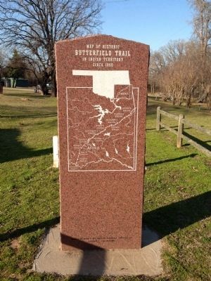
On September 16, 1857, the John Butterfield Company received a Federal contract to transport mail from Missouri to San Francisco in under 25 days. Semiweekly service began a year later. Twelve relay stations lined the Butterfield Trail in Indian . . . — — Map (db m64072) HM
You Are Now Entering Old
No Man's Land
Colorado Kansas 37th Parallel
Called "No Man's Land" until 1890
Known Then as
Beaver County
Became the Panhandle of Okla. Statehood 1907
Texas State Line 36° 30" Parallel
The . . . — — Map (db m93483) HM
This 168 mile trail from Mobeetie, Texas, to Dodge City, Kansas,
was laid out by Ed Jones and Joe Plummer in 1874, originally as a
freight trail for hauling buffalo hides purchased from the Buffalo
Hunters in the Texas Panhandle for sale at . . . — — Map (db m162472) HM
Eureka was established in 1908 with 18 square miles. The high school was started in 1919 when Center, Lincoln, and one half of Pleasant View were consolidated. In 1923, the Nabisco, Happy Flat, and East Banner districts were added and a new building . . . — — Map (db m78816) HM
In honor of the people who lived here from 1892 to 1957, and built this community.
Life in the community, which at one time included 2 general stores, a barber shop, blacksmith shop, grain grinding mills, church and family residences, centered . . . — — Map (db m209528) HM
This is dedicated in loving memory of Elmer "Red” and Elsie G. Cruze,
early day settlers of the Indian Creek area, north of Carter, Oklahoma.
Elsie moved to the Indian Creek area at the age of 3, with her parents
Pearl J. and Kate King, . . . — — Map (db m162457) HM
In 1888 Thomas and Millie Price were one of the first families to settle in this portion of old Greer Co, now Beckham Co. Price built a cotton gin ½ mi. east of Delhi in 1903. The one-roomed Delhi Academy was established in 1921. The Academy . . . — — Map (db m54903) HM
Chief Henry Roman Nose, for whom this park is named, was one of forty-four chiefs of the Southern Cheyenne tribe. He was a council chief from 1897 until his death in 1917. Born in 1856, Roman Nose (Woqini in the Cheyenne language) grew up during . . . — — Map (db m184807) HM
Ben Siegel at age 14 came to America from Lithuania. He established a business in Caddo, Indian Territory in 1895. One of Bryan County's first merchants, he was an important part of the early trade area. — — Map (db m73423) HM
John S. Hancock and his young son Clement Allen Hancock followed the MKT Railroad to Caddo in 1872. They established a business at this location and became two of Caddo's founding businessmen and community leaders. — — Map (db m73410) HM
Ferry owned by B.F. Colbert, at old crossing on Red River 3 miles south, was noted on the Butterfield Overland Mail line, organized, 1857; first U.S. mail route by stage between cities of St. Louis and San Francisco. Colbert post office was . . . — — Map (db m189885) HM
Before Oklahoma was a state, this tree gained the title of “The Message Tree”. Everyone in this area who needed to communicate with a loved one or business partner knew to nail a message to this tree.
This area where the travel center is . . . — — Map (db m244745) HM
Powhatan --- 1595 to 1617
Noted as the Angel of Mercy who saved
the starving colonists of Jamestown, Virginia
Sculptor: Kenneth F. Campbell
Donor: National Society of the Colonial Dames XVII Century — — Map (db m7619) HM
Established in 1911 and known as Science Hill. The school house was located one half mile east of this memorial. Later the name was changed to Britton School in honor of the pioneer family. The church located at the same site served as a Grade . . . — — Map (db m142497) HM
Mennonites settled in this area soon after Oklahoma territory opened by run April 22, 1889. Their first mission activity was among Indians. This colony was southernmost for Mennonites along Chisholm Trail. Farmers of Swiss (from Berne, Ind.), . . . — — Map (db m186333) HM
The Noble Brothers, Sam and Ed, arrived in Ardmore, Chickasaw Nation, in 1893, from Oakland Prairie, Pickens County, after a brief sojourn in Pottsboro, Texas, where they were partners in a general merchandise business and operated a ferry crossing . . . — — Map (db m142481) HM
Production of crude oil from the newly-discovered Healdton field surrounding this marker site flooded the marker with an oversupply of petroleum protesting that pipeline purchases were inadequate. Producers claimed they were being deprived of . . . — — Map (db m180600) HM
Center of Cherokee culture was one mile east on Park Hill Creek; Home of Chief John Ross, Samuel Austin Worcester, Elias Boudinot, other pioneers and The Mission Press which printed millions of pages for the benefit of the Cherokee people nearly . . . — — Map (db m52751) HM
Established July, 1837, Rev. S.A. Worcester, Supt. Over 25 million pages were printed in Indian languages and in English by 1861. Printers and translators were John F. Wheeler, John W. Candy, Edwin Archer, Stephen Foreman. Near site are graves of . . . — — Map (db m52755) HM
(front)
The United States Government, unable to conclude an agreement with the duly authorized leaders of the Cherokee Nation, signed a treaty with a minority faction willing to cede the last remaining portion of the original Cherokee . . . — — Map (db m77932) HM
"Doaksville is a small but pleasant looking village. There are a number of neat, if not tasteful dwelling houses, and two stores, which I found contained a little of almost everything from hoops to hunting shirts. It has a respectable looking . . . — — Map (db m237362) HM
This is one of three wells known in Doaksville; one is a short distance to the north while the other is in the vicinity of the hotel. At this location, archaeologists found that a stone pavement surrounded the well. Archaeological evidence . . . — — Map (db m238724) HM
The building that was once at this location is very different from other excavated at Doaksville. Here, a rock-walled cellar defines the footprint of a small building with a large fireplace. The cellar, which was excavated by archaeologists and . . . — — Map (db m238332) HM
Archaeologists found the partial remains of two different buildings when this site was excavated in 1995 and 1996. All that remained of one building was a section of stone foundation. The construction of this wall showed that it was the northwest . . . — — Map (db m238985) HM
Despite the importance of Doaksville prior to the Civil War, there is very little information about what the town looked like at that time. In order to have a better understanding of the town, archaeologists excavated the remains of a mercantile . . . — — Map (db m238238) HM
This site is at the north end of Main Street, called "Commercial Row," in this town begun in 1831. Name of nearby post office, "Fort Towson," was changed to Doaksville on Nov. 11, 1847. — — Map (db m52564) HM
Established in the early 1800's, and in continuous use, its name was taken from the now vanished town of the same name, just East of these grounds.
Marble Tombstones, brought by steamboat from New Orleans, show the high regard frontier . . . — — Map (db m237045) HM
Doaksville is a small place, containing fifty or sixty people, consisting mostly of traders and mechanics. It has six stores, two saddler shops, one tailor, one blacksmith, one cabinet, and one shoemaker shop, also a drug store and a public . . . — — Map (db m239334) HM
Archaeologists spent the summers of 1995, 1996, and 1997 digging to unravel the mysteries of this area. All that was visible before they began was a small, low, earth mound with a few protruding rocks and brick fragments. The archaeologists . . . — — Map (db m238283) HM
Established May, 1824, under command of Col. Matthew Arbuckle to guard this region of Spanish border. Headquarters of Gen. S.B. Maxey, U.S. Army. Abandoned at end of Civil War. In the vicinity, Doaksville was important trading center and one time . . . — — Map (db m52576) HM
Many whites had settled in what is today southeastern Oklahoma prior to the removal of the Choctaws to Indian Territory following the Treaty of Dancing Rabbit Creek in 1830. This unauthorized settlement was a problem during the initial . . . — — Map (db m238771) HM
"The famous old military road came in from Arkansas to Fort Towson near Doaksville, thence in a westerly direction to Armstrong Academy to Washita, Tishomingo, thence west to Fort Arbuckle." Matthew Walton James, 1937
[In 1879] . . . — — Map (db m237791) HM
The post's sutler was a civilian storekeeper permitted by the Federal government to operate a trading house on or near a fort. His general merchandise business provided goods and services not regularly supplied by the military. It was also open to . . . — — Map (db m239504) HM
The public house is owned by Col. David Folsom one of the principal men in the Choctaw Nation. He keeps an excellent house on strictly temperance principles. He also owns the blacksmith shop. Rev. P.P. Brown, 1847
Hotels during the . . . — — Map (db m238382) HM
Economic and political changes to the region surrounding Doaksville caused this community to decline rapidly in late 1860s and 1870s. There is little archaeological evidence of sustained activity at this place after about 1870.
In 1854, Fort . . . — — Map (db m239198) HM
To commemorate the history of Doaksville, the first historical marker was placed in 1960. A second commemorative marker was placed in 1965 to acknowledge the 100th anniversary of General Stand Watie's surrender. At the end of the Civil War on June . . . — — Map (db m238464) HM
Prior to 1830, Mississippi was the Choctaw homeland. The Choctaw migration to a new western homeland began shortly after the Treaty of Dancing Rabbit Creek was signed in 1830. The Choctaw people relocated to Indian Territory, traveling overland . . . — — Map (db m238148) HM
During the early 1800's, present Southeastern Oklahoma was a major transportation crossroads. Roads connected Fort Towson in the Choctaw Nation to military installations to the North, South and West. On the Texas side of the Red River, Jonesboro was . . . — — Map (db m52580) HM
The mounds at Doaksville were once thought to have formed when masonry buildings or chimneys collapsed. Over time, it was thought the resulting pile of rubble became covered with soil. However, when archaeologists excavated this site and the jail, . . . — — Map (db m239134) HM
(left panel) A Bridge Between the United States and Mexico
Before you is a portion of the historic Santa Fe Trail. Established as a wagon route by William Becknell in 1822, the Santa Fe Trail became the first major trade link between . . . — — Map (db m131308) HM
Canadian River was south line of “Old Oklahoma” opened by Run at 12 o’clock noon, April 22, 1889. Riders started at river crossing near here. Many thousands entered the 2,000,000 a. tract north: homes were planted and tent cities . . . — — Map (db m144698) HM
Located 1 mi. S of here on Chisholm Cattle Trail, also called Arbuckle Cattle Trail, Blue hired Cherokees and Creeks to kill wild buffalo in early 1870s and to deliver the hides to Atoka for shipment east. — — Map (db m141848) HM
Fort Sill was named by General Orders No. 25, HQ, Department of the Missouri, U.S. Army, on July 2, 1869. The post's name honors the memory of Brigadier General Joshua W. Sill, killed at the Battle of Stone River, Tennessee, in December, 1862. . . . — — Map (db m44709) HM
Erected in 1870, and built of limestone quarried from a nearby hill, the Post Headquarters building housed the administrative offices. The Commanding Officer, his executive officer, the adjutant, a sergeant and a signal officer worked here. The . . . — — Map (db m60883) HM
In memory of William H. Quinette, Post Trader, 1878-1915. Old crossing on road to Fort Cobb. General Sheridan's HQ mess tent was pitched here 10 Jan - 23 Feb 1869 when he founded Fort Sill. — — Map (db m82383) HM
Kiowa Chief Stumbling Bear who signed the Medicine Lodge Treaty, 1867, founded the first permanent settlement on Canyon Creek, southwest of here. First Government-built houses for Indians were erected in the settlement, 1877. — — Map (db m108856) HM
The Ferguson family built this beautiful cobblestone home in 1927. Ben and Margaret Ferguson, along with their 10 children, grew hay and garden vegetables, raised cattle, and planted a small fruit orchard with the help of his oldest sons. Ben . . . — — Map (db m180339) HM
This home and the Earl Ingram Homestead east of here were both built out of the round granite core stones that cover the hillsides of the refuge, and both were acquired during the 1901 land lottery held at Fort Sill. They reflect the hard work, . . . — — Map (db m180403) HM
At the opening of Kiowa-Comanche-Apache lands, the original townsite in old Comanche County was SW 1/4, T2S, R11W. The original name McKnight was rejected by the post office. The name Walter, for City Commissioner W.R. Walter, was then chosen Sept. . . . — — Map (db m119434) HM
Will Rogers formed lifelong ties to Vinita by attending school here, the Worcester Academy, 1889 and the Willie-Hasell College, 1894 and 1895 terms.
In 1934, Will returned for a WHC reunion and spoke at Old Settlers Day. He urged friends, . . . — — Map (db m67804) HM
In 1895 a concrete walk was installed by the City of Bristow across Main Street at 7th Street. The sloping sides allow the wagons to cross the walk. When Main Street was paved in 1915 the walk was removed. Both the installation and removal were . . . — — Map (db m41941) HM
[There are several dozen family histories on permanent markers on the plaza. One marker is transcribed, while the names on the other markers are listed for future reference]
The Abrahams [on Panel 1]
Only a little inquiry is needed . . . — — Map (db m41953) HM
Site of ranch headquarters was 2-1/2 mi. north of here. Roundups were on present site of Cushing. This area was grazing land for Texas cattle driven north, 1866 to 1885. The region was opened to settlers on Sept. 22, 1892. Sac and Fox village 1/4 . . . — — Map (db m187809) HM
Began 1/4 mi. east on the Creek Headrights of Tom & Hazel Mann. Town was named for Mann's Ford across Cimarron R. In 1895 G.M Evans leased this 90 acres and surrounding land. AV&W-RR (Frisco) came in 1902 and P.O. est. Apr. 11, 1903. Hall C. Miller . . . — — Map (db m185001) HM
Creek Indian "Chief" Sapulpa had a ranch, blacksmith shop and store here by 1850. Serving in Confed. Army, he was discharged a Lieut., and is buried N. of his old homestead in cemetery owned by Nancy Green Chap., NSDAR, 2 blks. S. Local RR station . . . — — Map (db m180760) HM
Near here on May 28, 1849, was the camp of a large party of gold seekers en route to California with a military escort under the command of Captain R. B. Marcy. The California Road was used by travelers for over 50 years. East of here about 4 miles . . . — — Map (db m39802) HM
On Now. 13, 1892, Grand was established as county seat of Day County, Oklahoma Ter. This was County "E" when organized at the opening of Cheyenne and Arapaho lands, April 19, 1892. Day County and county seat were abolished at statehood in 1907. Many . . . — — Map (db m181526) HM
At the opening of "Old Oklahoma", April 22, 1889, this was the north line for the Run starting at 12 o'clock noon. Prairies and hills in the 2,000,000 acre tract, south, were peopled by tens of thousands, homes were planted and tent cities sprang up . . . — — Map (db m39796) HM
This is the only remaining United States Land Office from the six Oklahoma land runs (1889-1896) and other Oklahoma land openings. This office was built in Enid for the registration of claims in County O, later named Garfield County, for the land . . . — — Map (db m215978) HM
The east-west section line one mile south of this marker was formerly Locust Street, in Charleston, Okea. The first post office was established June 18, 1901. Approximately one and one half mile south and one half mile west of here near the center . . . — — Map (db m181525) HM
[front side] The signing of the Treaty of Dancing Rabbit Creek on Sept. 27, 1830, was the final negotiation to remove the Choctaws from their ancestral homelands in Mississippi and Alabama to Indian Territory. The trip covered 600 miles. . . . — — Map (db m165637) HM
One of the earliest port towns and trading centers in Choctaw Nation, I.T. Choctaws brought from Mississippi up Arkansas River to Tamaha on steamboats as early as 1831. Tamaha developed as port and ferry crossing around 1836. Post office built 1884 . . . — — Map (db m76457) HM
This monument is dedicated to the thousands that lie forgotten in unmarked graves throughout present day Haskell County, Oklahoma, formally Sans Bois County, Choctaw Nation, Indian Territory. From the late 1840’s until the first days of the Civil . . . — — Map (db m165638) HM
Memorial to one of the earliest port towns and trading centers in the Choctaw Nation, I.T. Choctaws brought from Mississippi up Arkansas River to Tamaha on steamboats as early as 1831. Tamaha developed as port and ferry crossing around 1836. Post . . . — — Map (db m77875) HM
Hand dug in 1889-90 by Mr. Sam Neal who homesteaded on the lands that comprise downtown Altus. This well provided the lone soft water supply to the town for several years. It was 35 feet deep and was walled with brick. Rediscovered in 1989, this . . . — — Map (db m180123) HM
Began in southern Texas after Quanah Parker and the Comanches surrendered at Fort Sill in 1875. Due to the failing Post-Civil war economy in Texas, ranchers developed a 1,000 mile trail to Dodge City, Ogallala, and other northern markets to receive . . . — — Map (db m180178) HM
Friendship
Friendship was once called Alfalfa, serving as the site of the Alfalfa Post Office from 1903 to 1905. Clabber Flat School, which began one mile west and one-half mile north of here in 1899, became the first Friendship School, . . . — — Map (db m182289) HM
Chisholm Trail Lookout Point
This site was given by Henry and Blanche Price in honor of the Pickens County Cowpunchers Association and all other cowboys and pioneers that used this trail
Replaced March 2007 Oklahoma Centennial . . . — — Map (db m142229) HM
This is the only county seat on the 98th Meridian in Oklahoma. Townsite, west side of line, was in Kiowa-Comanche Reservation opened to settlement on Aug. 6. 1901. Moneka was the post office, established 1895, on east side of line, in Pickens Co., . . . — — Map (db m181531) HM
This monument is dedicated to the settlers who on September 16, 1893 made the last run when the Cherokee Outlet was opened to homesteaders, and to the pioneers whose courage and toil shaped a barren prairie into a flourishing land for generations to . . . — — Map (db m205994) HM
Dedicated to the Homesteaders of Kay County in recognition of their courage, faith, and fortitude in settling this portion of the Cherokee Outlet. Nearly 100,000 eager land seekers raced for claims in the greatest land run in history on September . . . — — Map (db m205718) HM
Front
Braman
When the Santa Fe Railroad was extended from Hunnewell, Kansas to Tonkawa, a railroad promoter named J.W. Whistler chose the midway point as a good location for a town. With B.J. Templeton he bought the . . . — — Map (db m96590) HM
First newspaper printed in the Cherokee Strip, June 14, 1884. Published at tent town of Rock Falls, 2.5 miles N.W. of here by Capt. David L. Payne, leader of Oklahoma "Boomers". Printing office was burned and "Boomers" disbanded by U.S.
Troops, . . . — — Map (db m96589) HM
September 11, 1893
Thousands of Americans gathered in this township preparing to make the run for homesteads in the Cherokee Strip, a tract of land 58 miles wide, opening 6,500,000 acres for White settlement bought from the Cherokee . . . — — Map (db m60480) HM
The original town of Kaw City was established in Oklahoma Territory in the Ox Bow Bend of the Arkansas River by the Kaw City Townsite Company. The company consisted of William M. Jenkins, fifth territorial governor of O.T., N.F. Frazier, C.W. . . . — — Map (db m206269) HM
From the beginning, African-Americans settled and lived in Newkirk -- although this was not true in most of the towns in Kay County. They settled primarily on the east side of town, building their own community which included churches, . . . — — Map (db m60443) HM
Newkirk owes its existence not simply to the opening of the Cherokee Outlet to homesteaders, but to the twenty-one allotments taken by the Cherokees in Kay County prior to the opening. The Outlet comprised eight million acres of prairie which . . . — — Map (db m60457) HM
The entire east side of the 100 block of North Main burned to the ground November 15, 1901. Some of the citizens (obviously not the ones whose businesses were destroyed) thought this was a blessing in disguise. The block consisted of frame . . . — — Map (db m60460) HM
This statue, "Land of Hope," depicts the courageous pioneers who staked their land claim in the "Land Run of the Cherokee Outlet" in 1893. This was created by sculptor, Bernadette Hess Carman, a native daughter, who generously donated her time . . . — — Map (db m60449) HM
Newkirk was originally platted as the townsite of Lamoreux by the United States Land Office in 1893 as the county seat of "K" county. It was named after Silas W. Lamoreaux who was the head of the General Land Office in Washington, D.C., at the . . . — — Map (db m60455) HM
The Newkirk Kay County Fair was organized in 1896. Five dollar shares were sold in order to purchase property for the facilities, build a race track, grand stands and sheds. The share also gave free admittance to all shows and fairs for three . . . — — Map (db m60459) HM
A centennial tribute to the people who shared this land at the turn-of-the-century, and who still call it home today. They faced opportunties and obstacles together and were woven together in time. The spirit that fueled the dream then, and the . . . — — Map (db m60458) HM
William S. Cline had this building constructed in 1925. This was the same year that the Kay County Courthouse and the Masonic Temple were constructed in Newkirk. The Cline Building is illustrative of the influence of the Art Deco style. . . . — — Map (db m60478) HM
This was the U.S. Land Office site for filing claims at opening of "Old Oklahoma," April 22, 1889; also at opening of Cheyenne and Arapaho lands on April 19, 1892. J. C. Robberts was first Register, and J. V. Admire, first Receiver. First . . . — — Map (db m29318) HM
This stage station on the old Chisholm Trail, 1867-1889, was 4 blocks no., on south side of Kingfisher Creek. The trail had two branches in this area; one for cattle was 6 miles east. — — Map (db m185854) HM
On this line -- 98° W. Longitude -- many campers sat by their fires the night before the opening of "Old Oklahoma." The next day at noon on April 22, 1889, many people set out running on foot and by horse for 160 acre land claims in unassigned . . . — — Map (db m185808) HM
East boundary of Indian country -- 98° W. Longitude west of this line lay the land of the Cheyenne and Arapaho. Each member of their two tribes had been allotted 160 acres before the surplus land was opened to settlers. At noon April 19, 1892 they . . . — — Map (db m185816) HM
Hobart was named to honor Garret A. Hobart, 24th Vice President of the United States.
Hobart was the first town in Okla. to adopt a city flower 'the iris' In appreciation A birthday gift from the people of Hobart to their town on August 6, . . . — — Map (db m167255) HM
"Warrior who perseveres" Born 1770 "Chief Moshulatubbee of Northern District, Choctaw Nation in Mississippi, received his name as a young warrior. He was dignified in bearing, of fine physique, steady and thoughtful in disposition. As Chief he . . . — — Map (db m190228) HM
Building completed, and Maj. F.C. Armstrong was first agent in 1832. Village became known as Skullyville. Choctaw Nation adopted new constitution in convention here, 1857. Stage station for Overland Mail to San Francisco 1858-61. Leading Choctaws . . . — — Map (db m77871) HM
Skullyville was founded in 1832 while removal of Choctaws to what is now Oklahoma was in process. First Choctaw Agency in the West was established here with Major F.W. Armstrong as agent.
The name Skullyville was derived from Choctaw word . . . — — Map (db m64486) HM
(front)
The founding of Skullyville dates back to 1832 when the removal of the Choctaws was in full progress. The old cemetery has all the interest usually attached to these places. Early on our people used rocks and stones to mark their . . . — — Map (db m77924) HM
Depressions in the ground, charcoal from cooing fires, middens or "garbage heaps". stone hoes and pottery fragments are all clues to the prehistoric sites along the Kiamichi River below. These clues reveal that people were farming and storing food . . . — — Map (db m194568) HM
This road extended through the Choctaw Nation over 130 miles of rugged terrain and raging streams. It was blazed by Col Robert Bean and constructed by Captain John Stuart and used to carry supplies and move troops and emigrants through the region. . . . — — Map (db m194906) HM
The Choctaw Indians placed a high priority on education. Boarding schools and small neighborhood schools existed as early as 1832 in Indian Territory. Although tribal funds supported the schools, missionaries were often responsible for . . . — — Map (db m194565) HM
Built 1910 - 1911
Mayors J. A. McLaughlin,
H. C. McGoughy and A. B. Oleson
Street Commissioners: H. C. Tuttle 1910,
and D. D. Landsaw 1911
Dedicated Historical Site
October 1978 — — Map (db m41780) HM
260 entries matched your criteria. The first 100 are listed above. Next 100 ⊳