On Sandown Avenue just east of Kingston Road, on the left when traveling east.
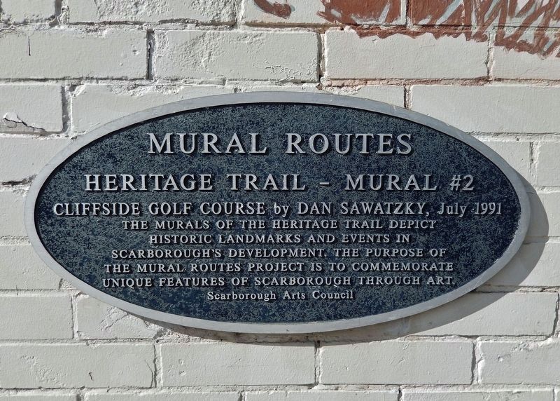
In 1931 George McCordick converted an old farmhouse into a clubhouse and turned the surrounding countryside into a challenging golf course. The Cliffside Golf Course was located south of Kingston Road and west of Midland Ave. with a beautiful . . . — — Map (db m217878) HM
On Kingston Road south of Sandown Avenue, on the right when traveling south.
by Risto Turunen, October, 1992 Wrote Elizabeth Simcoe in 1793 “…After rowing a mile we came within sight of what is named, in the map, the Highlands of Toronto. The shore is extremely bold and has the appearance of chalk cliffs… We talked of . . . — — Map (db m236694) HM
[First Panel:] 9 April 1940 Norway was attacked by overwhelming forces. King Haakon VII, Crown Prince Olav and the government left Tromso 7 June for Great Britain in order to continue the fight for freedom in exile. Negotiations had . . . — — Map (db m20989) HM
Near Queen's Park Crescent West, 0.2 kilometers south of Wellesley Street West, on the left when traveling south.
Born near Edinburgh, Scotland, Brown emigrated with his father to New York in 1837. In 1843 he moved to Toronto and the following year founded the “Globe” newspaper which achieved great political influence. Elected to the legislature as a reform . . . — — Map (db m207894) HM
Near Queen's Park Crescent East at Grosvenor Street, on the left when traveling north.
Born in St. Raphael, Macdonald was first elected to represent Glengarry in the legislature of the Province of Canada in 1841. He became one of the leaders of the Reform Party and served in several administrations prior to Confederation in 1867. . . . — — Map (db m208016) HM
On Queen's Park Crescent East at Queens Park (University Avenue), on the left when traveling north on Queen's Park Crescent East.
This tree was planted by James Simpson, Esq., Mayor of Toronto, on the occasion of the celebration of the twenty-fifth anniversary of the accession of King George the Fifth to the Throne — May 6th 1935 — — — Map (db m243754) HM
On Queen's Park Crescent East just north of Grosvenor Street, on the left when traveling north.
[English] The first university in this province, King's College was chartered in 1827 through the efforts of the Reverend John Strachan. This site was acquired by the College the following year. Sectarian and political criticism of . . . — — Map (db m207856) HM
On Queen's Park Crescent East just north of Grosvenor Street, on the left when traveling north.
Born in Cotterstock, Northamptonshire, Simcoe entered the army in 1770, and during the American Revolution commanded the 1st American Regiment (Queen’s Rangers). In 1791 he was appointed the first Lieutenant-Governor of the newly formed province of . . . — — Map (db m207899) HM
Near Queen's Park Crescent East at Grosvenor Street, on the left when traveling north.
[English] As part of the Legislative Assembly’s Millennium celebrations, these red oak trees were planted by The Hon. Gary Carr, MPP, Speaker, Mr. Sean Conway, MPP, Dean of the House and the Pages of the Legislative Assembly (Group . . . — — Map (db m243779) HM
On Queen's Park Crescent East, 0.1 kilometers north of Grosvenor Street, on the right when traveling north.
[English] The Ontario Human Rights Code came into effect on June 15, 1962 and established equal rights and freedom from discrimination as primary elements of provincial law. The first legislation of its kind in Canada, the . . . — — Map (db m207885) HM
Near Queen's Park Crescent East just north of Grosvenor Street, on the left when traveling north.
The precise geographic position of the Geodetic Station “Ontario Post One” is latitude 43° 39’ 45.421” North-longitude 79° 23’ 26.620” West. The coordinate position in the Ontario Coordinate System based on the North American Geodetic Survey 1927 . . . — — Map (db m243784) HM
Near Queen's Park Crescent East at Grosvenor Street, on the left when traveling north.
Born at Kensington Palace, the daughter of Edward, Duke of Kent, King George III’s fourth son, Alexandrina Victoria became Queen at the death of her uncle, King William IV, in 1837. Although she never visited Canada, her son, Edward, Prince of . . . — — Map (db m207900) HM
Near Queen's Park Crescent East at Grosvenor Street, on the left when traveling north.
[English] In 1859, the city leased land here from King’s College, and in 1860 a park, named after Queen Victoria, was opened by the Prince of Wales, later Edward VII. Queen’s Park was long considered as a location for new parliament . . . — — Map (db m207768) HM
On Queen's Park Crescent West at Queens Park (University Avenue), on the left when traveling south on Queen's Park Crescent West.
[English] Officially opened by the Prince of Wales (later King Edward VII) during the Royal Tour of 1860, Queen's Park is an early example of the public park movement in Canada. Landscaped according to a picturesque design, its . . . — — Map (db m207767) HM
Near Queen's Park Crescent East at Grosvenor Street, on the left when traveling north.
Born in Williamsburg Township, Dundas County, and educated at the Cornwall Grammar School, Whitney was called to the Bar in 1876. He was elected to the Provincial Parliament as Conservative Member for Dundas in 1888. A noted orator, he was the . . . — — Map (db m207891) HM
Near Queen's Park Crescent West, 0.2 kilometers south of Wellesley Street West, on the left when traveling south.
Born in Kingston, Mowat studied law under John A. Macdonald. After moving to Toronto in 1840, he was elected a liberal member of the legislature of the Province of Canada in 1857 and served as Provincial Secretary in 1858 and Postmaster General, . . . — — Map (db m207895) HM
Near Queens Park Crescent West just south of Wellesley Street West, on the left when traveling south.
[English] The "Mac-Paps" were a unit of the International Brigades, a volunteer force recruited world-wide to oppose the fascist forces bent on overthrowing the government of Spain. Formed in Spain in 1937, the battalion was named . . . — — Map (db m207700) HM
On Queen's Park Crescent East at Grosvenor Street, on the right when traveling north on Queen's Park Crescent East.
[English] The Nine-Hour Movement of 1872 was a broad labour effort to achieve a shorter work day through concerted strike action. The printers of the Toronto Typographical Union went on strike for a nine-hour day in late March. On . . . — — Map (db m207870) HM
On Queen's Park Crescent West just south of Wellesley Street West, on the left when traveling south.
[English] The Royal Tour of 1939 was the first visit to Canada by a reigning British monarch. Between May 15 and June 15, King George VI and Queen Elizabeth travelled by train across the country. They arrived at the North Toronto . . . — — Map (db m207836) HM
Near Queen's Park Crescent East just north of Grosvenor Street, on the left when traveling north.
Representing the billionth forest tree seedling distributed from Ontario Government nurseries since 1908, was planted on November 14th, 1968, by The Honourable John P. Robarts, P.C., Q.C., Prime Minister of Ontario. — — Map (db m243777) HM
On Queen's Park Crescent West just south of Wellesley Street West, on the left when traveling south.
Born near Dundee, Scotland, Mackenzie came to Upper Canada in 1820, and four years later founded a political newspaper, the “Colonial Advocate”, at Queenston. Sharply critical of the ruling oligarchy in the province, he entered politics, became . . . — — Map (db m207897) HM
After the Toronto Island parish was established in 1875 Bishop Arthur Sweatman was the prime mover in the building of this Anglican church. Designed by Arthur R. Denison, architect, the Early English Gothic style frame church was opened at the . . . — — Map (db m35520) HM
This lighthouse, one of the earliest on the Great Lakes, was completed in 1808 as an hexagonal tower 52 feet high, topped by a wooden cage with a fixed whale-oil lantern. In 1832 it was raised to 82 feet and later equipped with a revolving light. . . . — — Map (db m40779) HM
Near Front Street West at John Street, on the right when traveling east.
April 7, 1977 marked the introduction of Major League Baseball to Toronto when the Blue Jays Baseball Club played their first home game. They won that memorable opener, and have since brought great excitement and entertainment to the City. Playing . . . — — Map (db m199994) HM
On Front Street West just west of John Street, on the left when traveling west.
Considered among our finest poets, Isabella Crawford was born in Ireland and came to Canada with her parents about 1858. After settling first in Paisley, Ontario, the family lived later in Lakefield and Peterborough. As a young woman Isabella . . . — — Map (db m217200) HM
The layers of sand and clay exposed in these cliffs display a remarkable geological record of the last stages of the Great Ice Age. Unique in North America, they have attracted worldwide scientific interest. The first 46 metres of sediments contain . . . — — Map (db m39366) HM
On Kings College Circle at Galbraith Road, on the right when traveling east on Kings College Circle.
{Marker Text in English:}
Writer, artist, and illustrator of historical novels and textbooks, Charles Jefferys emigrated to Canada from England in 1879. After studying at the Toronto Art Students League, he joined the New York . . . — — Map (db m37092) HM
On University Avenue just south of Gerrard Street West, on the right when traveling north.
Procedures pioneered by William Thornton Mustard (born 8 August 1914 in Clinton, Ontario) had an historic impact on the field of surgery. He attended the University of Toronto Schools and the University of Toronto Medical School. During WWII while . . . — — Map (db m217699) HM
On University Avenue just north of Elm Street, on the right when traveling north.
Born in 1893 in a house that stood near this site, Gladys Marie Smith appeared on stage in Toronto at the age of five. Her theatrical career took her to Broadway in 1907 where she adopted the name Mary Pickford. The actress's earliest film, "Her . . . — — Map (db m199993) HM
On Queens Park (University Avenue) just north of College Street, on the left when traveling south.
[English] Notre place (Our Place) is a place of gathering, reflection and celebration that pays tribute to Ontario’s Francophonie. Notre place is an official legacy of the Commemoration of 400 years of French presence in Ontario . . . — — Map (db m243791) HM
On King's College Circle at Kings College Road, on the right when traveling east on King's College Circle.
{The marker has a both an English and French version. In English:}
In one of the most important advances in modern medicine, a team of investigators isolated and purified insulin in a building which stood on this site. On May 17, 1921, . . . — — Map (db m36194) HM
On Queen Street West at James Street, on the right when traveling west on Queen Street West.
City Hall was designed in 1887 by E. J. Lennox to fit this central site at the head of Bay Street. In one structure, these municipal buildings combined a City Hall, in the east portion, and Court-house in the west. The building, constructed mostly . . . — — Map (db m196173) HM
On Richmond Street East just west of Victoria Street, on the right when traveling west.
Once one of Toronto's grandest office buildings, this landmark served as the headquarters of the Confederation Life Association until 1955. Plans for the building arose from an international competition won by Knox, Elliot and Jarvis, architects. . . . — — Map (db m217687) HM
On Bay Street just north of Queen Street West, on the right when traveling north.
[English] Built between 1889 and 1899, this impressive Richardsonian Romanesque structure by local architect E. J. Lennox was the solution to the need of both the city of Toronto and York County for new quarters. Its superb downtown . . . — — Map (db m199998) HM
On Queen Street West just west of James Street, on the right when traveling west.
who masterminded much of the City’s Vital infrastructure, lived at Old City Hall from 1900 to 1909, and worked here from 1900 to 1945. — — Map (db m208079) HM
On Queen Street West at James Street, on the left when traveling east on Queen Street West.
In 1905, Timothy Eaton's department store began the tradition of the Santa Claus Parade. Initially, the parade featured Santa Claus on a horse-drawn cart. The parade has grown in size and splendour to include upside-down clowns, colourful . . . — — Map (db m200000) HM
On Queen Street East just west of Victoria Street, on the right when traveling west.
The Town Tavern, located here for 23 years, was an important part of the Yonge Street music scene. Opened in 1949 as a theatre restaurant, club owner Sam Berger turned the Town Tavern into a full-time jazz venue in 1955 at the suggestion of . . . — — Map (db m217797) HM
On Adelaide Street East just east of Spice Mill Lane, on the right when traveling east.
This building was Toronto’s city and county courthouse for nearly 50 years. It was Toronto’s third courthouse, designed by Cumberland & Ridout in the Classical Revival style, inspired by historic Greek architecture. Many high-profile trials were . . . — — Map (db m217427) HM
On Lombard Street at First Lane East, on the left when traveling west on Lombard Street.
Born into slavery in Delaware during the late 1850s, Albert Jackson became the first Black letter carrier in Toronto and one of the few people of colour to be appointed a civil servant in 19th-century Canada. Jackson's mother, Ann Maria, escaped . . . — — Map (db m217681) HM
On Victoria Street just south of King Street East, on the right when traveling north.
Presented to The King Edward Hotel to commemorate the Charter Meeting of The Rotary Club of Toronto held November 28, 1912 in celebration of the Club’s 100th Anniversary November, 2012 — — Map (db m217542) HM
On Toronto Street just north of Court Street, on the right when traveling north.
On March 23, 1998, to commemorate the 150th Anniversary of The Consumers’ Gas Company Ltd., these lamps were unveiled here at 19 Toronto Street, site of the Company’s head office from 1852 to 1976. The Company was first known for its lamplighters . . . — — Map (db m217414) HM
On Toronto Street just north of Court Street, on the right when traveling north.
This building was the headquarters of the Consumers’ Gas Company for 125 years. It was built in stages between 1852 and 1899 on what was one of Toronto’s principal financial streets. Architect Joseph Sheard designed the first building at 17 Toronto . . . — — Map (db m217415) HM
On Toronto Street just south of Adelaide Street East, on the right when traveling south.
This 11-storey building, designed by prominent Toronto architect E. J. Lennox, was the tallest building on the block at the time of construction. It was named after the Excelsior Life Insurance Company, whose offices were located within. It . . . — — Map (db m217511) HM
On Queen Street East just east of Bond Street, on the left when traveling east.
This "Cathedral of Methodism" was designed by Henry Langley in the High Victorian Gothic style. The cornerstone was laid by the Rev. Egerton Ryerson, D.D., in 1870 and the church was dedicated in 1872. It replaced an earlier structure at the . . . — — Map (db m207898) HM
On Richmond Street East at Yonge Street, on the left when traveling west on Richmond Street East.
The first Jewish congregation in Canada West, (now Ontario), was established on this site in 1856 (Jewish calendar 5615). Services were held in a rented hall on the upper floor over Coombe’s Drug Store on the corner of Yonge and Richmond Streets. . . . — — Map (db m217697) HM
On King Street East, 0.1 kilometers west of Jarvis Street, on the left when traveling west.
St. Lawrence Hall, one of the oldest public buildings in Toronto, was constructed following the Great Fire of 1849 that destroyed a large part of the city's core. Architect William Thomas designed the building in the Renaissance Revival style with . . . — — Map (db m217100) HM
On King Street East just east of Victoria Street, on the right when traveling east.
[English] The King Edward Hotel was built by George Gooderham's Toronto Hotel Company to meet the demand in the rising metropolis for a grand hotel. When it opened in 1903, the hotel, affectionately known as the “King Eddy”, was . . . — — Map (db m208383) HM
On Toronto Street at Old Post Office Lane, on the right when traveling south on Toronto Street.
[English] Built 1851-1853 for the Province of Canada, the seventh post office was designed by Toronto architects Frederic Cumberland and Thomas Ridout. The building, in the then popular Neo-classical style, resembles a Greek temple. The . . . — — Map (db m196176) HM
On King Street East just east of Church Street, on the right when traveling east.
[west side] The sculpture garden in this city park was constructed with generous contributions from the Louis L. Odette family and the Province of Ontario to promote the art of sculpture for the enjoyment of the people of Toronto. An art . . . — — Map (db m217547) HM
On Lombard Street at First Lane East, on the left when traveling west on Lombard Street.
This coat of arms was formerly located above the main entrance of Toronto’s eighth post office which was erected on part of this site in 1872-1873. The original building was designed by R. C. Windeyer, architect, and served as the main post office . . . — — Map (db m217655) HM
On King Street East at Leader Lane, on the right when traveling east on King Street East.
In 1798 the Town of York (now Toronto) erected its first jail and hanging yard on this site. Also known as 'the old log gaol', it was still standing when York opened a newer jail in 1827 (demolished 1960) on the NE corner of King and Toronto . . . — — Map (db m215791) HM
On Toronto Street at Court Street, on the right when traveling north on Toronto Street.
”Be of good courage boys. I am not ashamed of anything I’ve done, I trust in God, and I’m going to die like a man.” —Samuel Lount. On April 24, 1824 the cornerstone of York’s second jail was laid on this site. In the aftermath of the . . . — — Map (db m217533) HM
On King Street West at Emily Street, on the right when traveling east on King Street West.
St. Andrew’s was begun in 1874 to serve a Church of Scotland congregation organized in 1830. An outstanding example of Romanesque Revival architecture, this massive church was designed by William Storm (1826-92), a noted Toronto architect. The . . . — — Map (db m199996) HM
On Front Street West close to University Avenue, on the right when traveling west.
On this site stood the "Bishop's Palace", residence of Bishop John Strachan (1778-1867), built in 1817-18 while he was the incumbent of St. James' Church. Born in Scotland, he came to Upper Canada in 1799 where he achieved prominence as an educator . . . — — Map (db m83662) HM
On Yonge Street just south of Colborne Street, on the right when traveling south.
Opened as the Hotel Mossop, this eight-story structure was one of Toronto’s first fireproof buildings. It was constructed in the aftermath of the 1904 Great Fire of Toronto, which destroyed over 100 buildings west of here. As a result, architect J. . . . — — Map (db m217516) HM
On Queen Street West just west of Yonge Street, on the left when traveling west.
[English] Department stores revolutionized shopping in the late nineteenth century by offering selection, low prices and money-back guarantees. In 1895, Robert Simpson commissioned architect Edmund Burke to design his new department . . . — — Map (db m208195) HM
On King Street West just west of Jordan Street, on the left when traveling west.
Upon completion, this 34-storey skyscraper was the tallest building in the British Empire and was praised as the “greatest addition to Toronto’s increasing, Manhattan-like skyline.” It was designed for The Canadian Bank of Commerce jointly by the . . . — — Map (db m217198) HM
On King Street West at Yonge Street, on the right when traveling east on King Street West.
Founded in Toronto in 1869, the Dominion Bank moved its head office to this site ten years later. In 1914, the bank's rise to national prominence led to the construction of this early 12-storey skyscraper. Beaux-Arts in style with Renaissance . . . — — Map (db m217451) HM
On King Street West just east of Bay Street, on the left when traveling east.
The adjacent plaque was the first created by the Toronto Historical Board, and was installed in 1969 on an earlier building on this site. It marks the first place in Toronto where citizens were recruited and trained by the Royal Canadian Naval . . . — — Map (db m217587) HM
On Front Street West close to York Street, on the right when traveling west.
English:
Built on the site of the Queen's Hotel by the Canadian Pacific Railway in 1928-29, the Royal York Hotel was part of its coast-to-coast chain of grand hotels. The skyscraper hotel, designed by Montreal architects Ross and . . . — — Map (db m83660) HM
On King Street West just west of Bay Street, on the left when traveling west.
[English] Designed by Modernist architect Ludwig Mies van der Rohe in association with John B. Parkin Associates and Bregman and Hamann Architects, the Toronto-Dominion Centre is located in the heart of Toronto's financial district. . . . — — Map (db m199997) HM
On Fort York Boulevard at Bathhurst Street, on the right when traveling west on Fort York Boulevard.
This smoothbore, muzzle-loading gun, along with six others (five shell guns and a 32-pounder), was mounted as part of an improved harbour defence battery at Fort York just west of here in 1862. An additional training battery of two 32-pounders was . . . — — Map (db m237590) HM
Near Fort York Boulevard, 0.2 kilometers north of Lake Shore Boulevard West.
Originally a one-storey gunpowder magazine, this building's walls could not support the weight of the bombproof roof. The army replaced the roof and added a second floor in 1824 to store weapons and equipment. In 1838, the upper floor housed 5,000 . . . — — Map (db m237597) HM
Near Fort York Boulevard, 0.2 kilometers north of Lake Shore Boulevard West.
This battery saw action during the Battle of York in 1813. It survived the American occupation and became part of the rebuilt fort of 1813-15. Today it reflects its 1816 appearance, when it held two artillery pieces. It was modified to hold five . . . — — Map (db m237599) HM
Near Fort York Boulevard, 0.2 kilometers north of Lake Shore Boulevard West.
[English] Fort York constituted the primary defensive position in early York (Toronto). The present bildings, erected between 1813 and 1815 to replace those destroyed during the American occupations of York in 1813, are among the . . . — — Map (db m199282) HM
Near Fort York Boulevard, 0.2 kilometers north of Lake Shore Boulevard West.
From 1800 to 1813, 'Government House' stood in the centre of today's Fort York. It was the home and office of Upper Canada's lieutenant-governor, head of the colony's civil government. In stressful times, the office was combined with that of the . . . — — Map (db m237595) HM
Near Fort York Boulevard, 0.2 kilometers north of Lake Shore Boulevard West.
Like the No. 2 Blockhouse, this was one of the first buildings constructed during the refortification of Toronto in the second half of the War of 1812. The depression in the ground by the north wall is the approximate surface grade here in 1813; . . . — — Map (db m237598) HM
Near Fort York Boulevard, on the right when traveling west.
The first structures built at Fort York during the War of 1812 where blockhouses to house the soldiers. Thick, square-timbered walls (covered with ‘weather boards’) offered protection from bullets, exploding shells and small-calibre artillery. . . . — — Map (db m83745) HM
Near Fort York Boulevard, 0.2 kilometers north of Lake Shore Boulevard West.
In 1815 each of these buildings housed 100 people: soldiers, their wives and their children. In the 1820s, the army halved the number of occupants to improve living conditions. By the 1860s, only three men and their families lived in each room. . . . — — Map (db m237593) HM
Near Fort York Boulevard, 0.2 kilometers north of Lake Shore Boulevard West.
The Officers’ Blue Barracks housed junior officers: ensigns, lieutenants and some captains. Unlike the other structures in the fort, which are original to 1813-15, this building is largely a reconstruction. The army tore down the barracks' . . . — — Map (db m237596) HM
Near Fort York Boulevard, 0.2 kilometers north of Lake Shore Boulevard West.
One section of this building housed senior officers while another met most of the dining needs of all of the garrison officers. Sometimes officers lived here with their families, but most married officers lived more comfortably in town. Money vaults . . . — — Map (db m237594) HM
Near Fort York Boulevard, 0.2 kilometers north of Lake Shore Boulevard West.
The British Army constructed this building to house gunpowder and cartridges for artillery, muskets, rifles and other weapons. The magazine was bombproof in case of enemy attack. It also had features to prevent accidental explosions and to keep the . . . — — Map (db m237591) HM
English:
Loyal residents of York (Toronto) were encouraged by early British victories in the War of 1812, but in 1813, they experienced first-hand the hardships of war. On the morning of April 27th, an American fleet appeared offshore and . . . — — Map (db m83668) HM
Near Fort York Boulevard, 0.2 kilometers north of Lake Shore Boulevard West.
This reconstruction shows a typical 19th century British army well house. The hand-dug well was sunk in 1802, soon after Government House was built. The well is over seven metres deep, has an outside diameter of three metres, and is lined with . . . — — Map (db m237592) HM
On Lake Shore Boulevard West at Remembrance Drive, on the right when traveling east on Lake Shore Boulevard West.
Ben Dunkelman was a distinguished military officer, entrepreneur, and president of Tip Top Tailors, the menswear company founded by his father, David. Born and raised in Toronto, Ben Dunkelman fought with the Queen's Own Rifles of Canada regiment . . . — — Map (db m211254) HM
The design of a grand eastern entrance to the Canadian National Exhibition (CNE) was the result of visionary waterfront planning by Toronto architect Alfred H. Chapman. In the early 1920s, he was commissioned by the CNE to plan a major expansion of . . . — — Map (db m212905) HM
On Fleet Street at Angelique Street, on the left when traveling west on Fleet Street.
Now landlocked on Fleet Street, this lighthouse once stood on the Queen's Wharf. The wharf - originally known as New Pier - was built in 1833 to stimulate commercial activity in the west part of the harbour.
This lighthouse, constructed in 1861 . . . — — Map (db m211603) HM
On Princes' Boulevard at Canada Boulevard, on the right when traveling east on Princes' Boulevard.
This entrance to the Canadian National Exhibition grounds was built in 1927 to commemorate 60 years of Canadian Confederation. The stone and concrete gates were designed by the Toronto firm of Chapman and Oxley and are a fine example of monumental . . . — — Map (db m211725) HM
The Princes' Gates were officially opened on Tuesday August the Thirtieth — M•D•C•C•C•C•XXVII — by H.R.H. The Prince of Wales accompanied by H.R.H. Prince George
First to pass through these gates was a Veterans' Parade under ethe . . . — — Map (db m212906) HM
On Princes' Boulevard at Canada Boulevard, on the right when traveling east on Princes' Boulevard.
At the end of the First World War (1914-1918), activities took place across Canada to commemorate the country's wartime efforts and to honour the over 60,000 Canadians lost. One of the most significant and lasting events was a veterans' parade held . . . — — Map (db m212903) HM
On University Street, 0.03 kilometers north of Dundas Street.
Panel 1:
Per Ardua Ad Astra
In Memory of our Canadian
Airmen who fought in the
Skies to preserve freedom
and order in the world.
Panel 2:
Canadian Airmen Awarded the Victoria Cross
World War I:
William . . . — — Map (db m57901) HM
On University Avenue just north of Queen Street West, on the right when traveling south.
[English] At the turn of the 20th century, as Toronto challenged Montréal as the banking capital of Canada, George Cox was among those in the vanguard. After a successful business career in Peterborough, he moved to Toronto where he . . . — — Map (db m208103) HM
On University Avenue just north of Queen Street West, on the right when traveling south.
[English] Campbell was born near Caithness, Scotland. He fought with the British forces during the American Revolution and was taken prisoner at Yorktown in 1781. Three years later he was practising law in Nova Scotia where, in 1799, he was . . . — — Map (db m208175) HM
On University Avenue just north of Queen Street, in the median.
South face of pedestal:
To the memory and in honour
of the Canadians who died defending the Empire
in the South African War, 1899-1902
South face of obelisk:
Paarderberg
Dreifontein
Johannesburg
Diamond Hill
Belfast . . . — — Map (db m57959) WM
On University Avenue just south of Armoury Street, on the right when traveling south.
As the United States marks the 10th Anniversary of the terror attacks of September 11, 2001, in the name of all Americans, Consulate General Toronto thanks the people of Ontario for their support and generosity following the worst attack on . . . — — Map (db m217796) HM
On University Avenue just north of Armoury Street, on the right when traveling south.
Founded in 1906 as a private dining club for those with a university degree, the University Club of Toronto moved to this location on Toronto's ceremonial avenue in 1929. A design competition for a new building — restricted to architects who were . . . — — Map (db m217701) HM
On Queen Street East just west of Connaught Avenue, on the right when traveling west.
[English] This property was home to one family for two centuries. Sarah Ashbridge and her family moved here from Pennsylvania and began clearing land in 1794. Two years later they were granted 600 acres (243 hectares) between . . . — — Map (db m208200) HM
On Don Mills Road at Saint Dennis Drive on Don Mills Road.
J. Tuzo Wilson (1908-1993) J. Tuzo Wilson, the world-renowned Canadian geophysicist, served as Director General of the Ontario Science Centre from 1974 to 1985. He was instrumental in developing the theory of Plate Tetonics in the 1960s. This . . . — — Map (db m92272) HM
On Jarvis Street just north of King Street East, on the right when traveling north.
Distinguished by buff brick detailing, this row of three-storey buildings was constructed for Clarkson Jones, a barrister living north on Jarvis Street. Early tenants included two fruiterers and a saddler. Designated under the Ontario . . . — — Map (db m217197) HM
On King Street East, 0.1 kilometers west of Jarvis Street, on the right when traveling west.
On June 21, 1832, the first cases of cholera, a highly contagious and deadly disease, appeared in the Town of York. Much feared, cholera first appeared in India in the 1770s, spreading along trade routes to Asia and Europe, and arriving in London, . . . — — Map (db m217097) HM
On Adelaide Street East just east of George Street, on the left when traveling east.
Designed by Toronto architect Henry Langley, this building was constructed as a boys school operated by the Brothers of the Christian Schools, a Catholic teaching order. The Brothers had purchased the former Bank of Upper Canada building to the . . . — — Map (db m217698) HM
On Jarvis Street just south of Adelaide Street East, on the right when traveling south.
Francis Collins, Canada’s first professional parliamentary debates reporter, was born ca. 1800 in Newry, County Down, Ireland. He had been a publisher before his arrival in York (Toronto) where, near here from 1825-1834 he published the “Canadian . . . — — Map (db m217798) HM
On Adelaide Street East just east of George Street, on the right when traveling east.
Canada’s largest biscuit manufacturer, Christie, Brown & Co., built this factory complex over a 40-year period. At its peak, it employed nearly 400 workers. The original three-storey building was enlarged and altered in a variety of architectural . . . — — Map (db m217792) HM
On George Street just north of Adelaide Street East, on the right when traveling north.
Toronto’s First Post Office Toronto's First Post Office is the oldest purpose-built post office in Toronto still standing and in operation. The building is a rare example of a post office that served as a department of the British . . . — — Map (db m217799) HM
On Adelaide Street East, 0.1 kilometers east of Church Street, on the right when traveling east.
Banished from Upper Canada in 1819 on false charges of sedition brought by the Family Compact. His writings had an impact on events leading to the 1837 rebellion. Robert Gourlay championed reforms ahead of his time. In Scotland — a vote for every . . . — — Map (db m217521) HM
On King Street East just east of Church Street, on the left when traveling east.
York's first church was built here in 1803-07 with the aid of public subscriptions and a government grant. That frame building was enlarged in 1818-19 and replaced by a larger one in 1831. The first incumbent was the Rev. George Okill Stuart, who . . . — — Map (db m199499) HM
On Lombard Street just east of Church Street, on the right when traveling east.
The St. James Parking Garage, which opened in 1925, was one of the first multi-level parking garages in Toronto. In the mid-1920s, increased demand for parking led to the construction of several parking garages in Toronto’s downtown core. . . . — — Map (db m217857) HM
120 entries matched your criteria. The first 100 are listed above. The final 20 ⊳