95 entries match your criteria.
Historical Markers and War Memorials in Queens County, Prince Edward Island
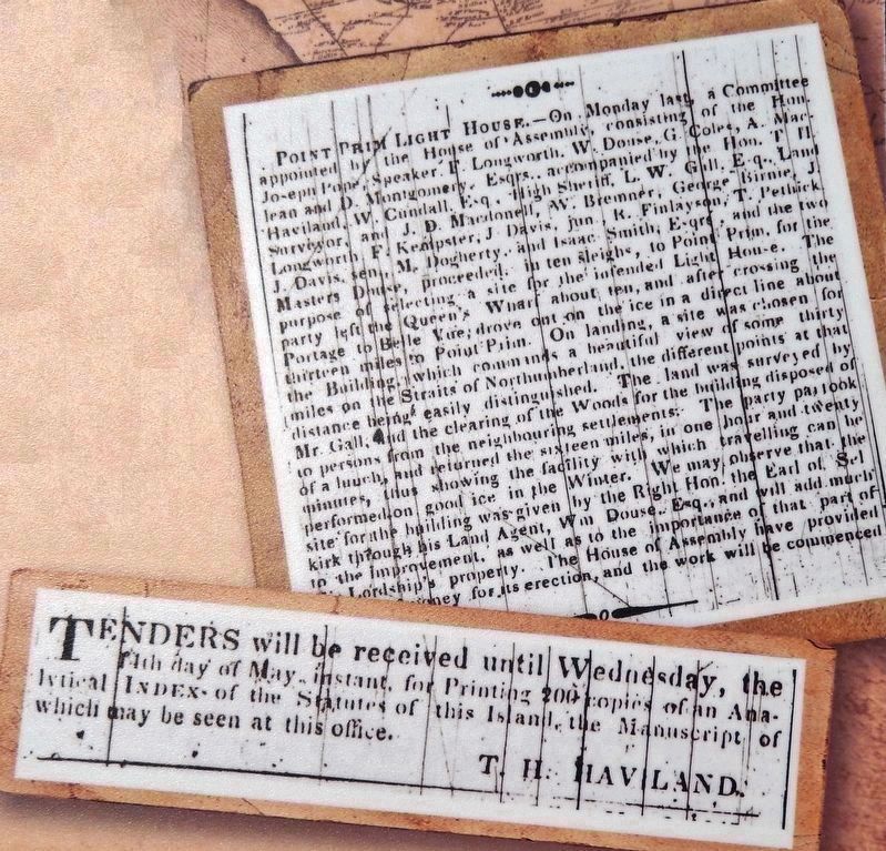
Marker detail: Lighthouse Survey and Tender /
Relevé de l’emplacement et Appel d’offres
Relevé de l’emplacement et Appel d’offres
| 1 ► Prince Edward Island, Queens County, Belfast — A Lighthouse is Born / La Naissance du Phare — |
| Near Point Prim Road (Prince Edward Island Route 209) 11 kilometers west of Trans-Canada Highway (National Route 1). | |||
| 2 ► Prince Edward Island, Queens County, Belfast — Point Prim Lighthouse / Le Phare de Point Prim — A Lighthouse to Call Our Own / Un Phare Bien à Nous — |
| Near Point Prim Road (Prince Edward Island Route 209) 11 kilometers west of Trans-Canada Highway (National Route 1). | |||
| 3 ► Prince Edward Island, Queens County, Belfast — Reliable Communication / Des Communications Fiables — Samuel Cunard, Mail Delivery / Samuel Cunard, la Livraison de la Poste — Prince Edward Island Steam Navigation Company — |
| Near Point Prim Road (Prince Edward Island Route 209) 11 kilometers west of Trans-Canada Highway (National Route 1). | |||
| 4 ► Prince Edward Island, Queens County, Belfast — The 1864 Charlottetown Conference / La Conférence de Charlottetown de 1864 — Lighting the Way / Un Feu qui Nous Guide — |
| Near Point Prim Road (Prince Edward Island Route 209) 11 kilometers west of Trans-Canada Highway (National Route 1). | |||
| 5 ► Prince Edward Island, Queens County, Belfast — The Early Years / Les Premières Années — |
| Near Point Prim Road (Prince Edward Island Route 209) 11 kilometers west of Trans-Canada Highway (National Route 1). | |||
| 6 ► Prince Edward Island, Queens County, Canoe Cove — Canoe Cove School — |
| On Canoe Cove Road (Prince Edward Island Route 19A) just north of Prince Edward Island Route 19, on the left when traveling north. | |||
| 7 ► Prince Edward Island, Queens County, Cavendish — Cavendish Dunelands Trail/Cavendish Sentier Dunelands — History of the Cavendish Area/Histoire de la région de Cavendish. — |
| Near Gulf Shore Parkway West. | |||
| 8 ► Prince Edward Island, Queens County, Cavendish — Cavendish Dunelands Trail/Cavendish Sentier Dunelands — Wreck of the Marco Polo/L'épave du Marco Polo — |
| Near Gulf Shore Parkway West. | |||
| 9 ► Prince Edward Island, Queens County, Cavendish — Cavendish Dunelands Trail/Cavendish Sentier Dunelands — Sea Stories/Légendes de la mer — |
| Near Gulf View Parkway West. | |||
| 10 ► Prince Edward Island, Queens County, Cavendish — Cavendish Dunelands Trail/Cavendish Sentier Dunelands — Cavendish and Tourism/Cavendish et le tourisme — |
| 11 ► Prince Edward Island, Queens County, Cavendish — Lucy Maud Montgomery — (1874 - 1942) — |
| Near Cavendish Road (Prince Edward Island Route 6) close to Prince Edward Island Route 13, on the right when traveling east. | |||
| 12 ► Prince Edward Island, Queens County, Charlottetown — A BIG Year / Une année CRUCIALE — |
| Near Grafton Street at Great George Street, on the right when traveling north. | |||
| 13 ► Prince Edward Island, Queens County, Charlottetown — A Centre for the Arts — Un centre des arts — |
| On Water Street (Prince Edward Island Route 1) at Grafton Street, on the left when traveling north on Water Street. | |||
| 14 ► Prince Edward Island, Queens County, Charlottetown — A Dutiful Citizen / Un citoyen consciencieux — |
| On Queen Street at Grafton Street, on the left when traveling south on Queen Street. | |||
| 15 ► Prince Edward Island, Queens County, Charlottetown — A Neoclassical Design / Un style néoclassique — |
| On Grafton Street at Great George Street, on the right when traveling east on Grafton Street. | |||
| 16 ► Prince Edward Island, Queens County, Charlottetown — A River of Importance — Une rivière d’importance — |
| On Grafton Street at Water Street (Prince Edward Island Route 1), on the right when traveling east on Grafton Street. | |||
| 17 ► Prince Edward Island, Queens County, Charlottetown — A Wet Warehouse in a Dry City / La sobriété avant tout — |
| On Water Street east of Queen Street, on the right when traveling east. | |||
| 18 ► Prince Edward Island, Queens County, Charlottetown — All Souls’ Chapel — |
| On Rochford Street close to All Souls' Lane, on the right when traveling north. | |||
| 19 ► Prince Edward Island, Queens County, Charlottetown — Andrew Archibald Macdonald — 1829 - 1912 — |
| Near Richmond Street near Great George Street. | |||
| 20 ► Prince Edward Island, Queens County, Charlottetown — Andrew's Millpond — |
| On Veterans Memorial Highway (St. Peters Road) (Prince Edward Island Route 2) just south of Oakland Drive, on the left when traveling south. | |||
| 21 ► Prince Edward Island, Queens County, Charlottetown — Angus Bernard MacEachern (1759- 1835) — |
| On Great George Street at Dorchester Street, on the right when traveling south on Great George Street. | |||
| 22 ► Prince Edward Island, Queens County, Charlottetown — Apothecaries Hall — |
| On Queen Street at Grafton Street, on the right when traveling south on Queen Street. | |||
| 23 ► Prince Edward Island, Queens County, Charlottetown — Beaconsfield Historic House / Maison historique Beaconsfield — |
| On Kent Street south of West Street, on the left when traveling south. | |||
| 24 ► Prince Edward Island, Queens County, Charlottetown — Beginnings of a Settlement — Les débuts de la colonization — |
| On Grafton Street at Water Street (Prince Edward Island Route 1), on the right when traveling east on Grafton Street. | |||
| 25 ► Prince Edward Island, Queens County, Charlottetown — Big Donald — |
| On Kent Street just south of Queen Street, on the left when traveling north. | |||
| 26 ► Prince Edward Island, Queens County, Charlottetown — Birthplace of Confederation — Le Berceau de la Confédération — |
| On Water Street (Prince Edward Island Route 1) at Grafton Street, on the left when traveling north on Water Street. | |||
| 27 ► Prince Edward Island, Queens County, Charlottetown — Canadian National Hotels — Rodd Hotels & Resorts — |
| On Kent Street close to Pownal Street, on the left when traveling east. | |||
| 28 ► Prince Edward Island, Queens County, Charlottetown — Carvell Building — |
| On Queen Street close to Water Street, on the right when traveling north. | |||
| 29 ► Prince Edward Island, Queens County, Charlottetown — Charlottetown — Prince Edward Island — |
| On Kent Street near Queen Street, on the left when traveling east. | |||
| 30 ► Prince Edward Island, Queens County, Charlottetown — Charlottetown and Quebec Confederation of 1864 — Charlottetown Site — One of Two Identical Markers — |
| On Richmond Street at Great George Street, on the right when traveling west on Richmond Street. | |||
| 31 ► Prince Edward Island, Queens County, Charlottetown — Charlottetown City Hall — Hotel de ville de Charlottetown — |
| On Queen Street near Kent Street, on the right when traveling south. | |||
| 32 ► Prince Edward Island, Queens County, Charlottetown — Charlottetown Railway Station — |
| On Weymouth Street at Water St, on the right when traveling north on Weymouth Street. | |||
| 33 ► Prince Edward Island, Queens County, Charlottetown — Choices For Higher Education — Les choix d’éducation supérieur — |
| On Grafton Street at Water Street (Prince Edward Island Route 1), on the right when traveling east on Grafton Street. | |||
| 34 ► Prince Edward Island, Queens County, Charlottetown — Colonel John Hamilton Gray — 1811 - 1887 — |
| On Richmond Street close to Great George Street. | |||
| 35 ► Prince Edward Island, Queens County, Charlottetown — Confederation Centre of the Arts — Centre de Arts de la Confédération — |
| On Grafton Street at Queen Street, on the right when traveling east on Grafton Street. | |||
| 36 ► Prince Edward Island, Queens County, Charlottetown — Dundas Terrace — |
| On Water Street at Haviland Street on Water Street. | |||
| 37 ► Prince Edward Island, Queens County, Charlottetown — Edward Palmer — 1809 - 1889 — |
| Near Richmond Street close to Great George Street. | |||
| 38 ► Prince Edward Island, Queens County, Charlottetown — Edward Whelan — 1824 - 1867 — |
| Near Richmond Street close to Great George Street. | |||
| 39 ► Prince Edward Island, Queens County, Charlottetown — George Coles — 1810 - 1875 — |
| Near Richmond Street near Great George Street. | |||
| 40 ► Prince Edward Island, Queens County, Charlottetown — Great George Street Historic District — L’arrondissement Historique de la rue Great George — |
| On Great George Street, in the median. | |||
| 41 ► Prince Edward Island, Queens County, Charlottetown — Heralded Arrival… of the Circus — L’arrivée tant attendue… du cirque — |
| On Great George Street close to Water Street, on the left when traveling south. | |||
| 42 ► Prince Edward Island, Queens County, Charlottetown — Hillsborough Bridge — Charlottetown, Prince Edward Island — |
| On Water Street close to Prince Street. | |||
| 43 ► Prince Edward Island, Queens County, Charlottetown — Impulsive Ambush / Une attaque impulsive — |
| On Water Street just east of Queen Street, on the left when traveling east. | |||
| 44 ► Prince Edward Island, Queens County, Charlottetown — Keeping the City Green — Une ville verte — |
| On Grafton Street at Water Street (Prince Edward Island Route 1), on the right when traveling east on Grafton Street. | |||
| 45 ► Prince Edward Island, Queens County, Charlottetown — Making History in 1864 — L'histoire en marche en 1864 — |
| On Water Street (Prince Edward Island Route 1) at Grafton Street, on the left when traveling north on Water Street. | |||
| 46 ► Prince Edward Island, Queens County, Charlottetown — Open Green Spaces in the City — Les espaces verts au cœur de la ville — |
| On Grafton Street at Water Street (Prince Edward Island Route 1), on the right when traveling east on Grafton Street. | |||
| 47 ► Prince Edward Island, Queens County, Charlottetown — Paardeberg — |
| On Richmond Street close to Great George Street, on the left when traveling east. | |||
| 48 ► Prince Edward Island, Queens County, Charlottetown — Peake House — |
| On Water Street close to Queen Street, on the left when traveling west. | |||
| 49 ► Prince Edward Island, Queens County, Charlottetown — Predominantly a Wooden Town — Une ville surtout faite de bois — |
| On Water Street (Prince Edward Island Route 1) at Grafton Street, on the left when traveling north on Water Street. | |||
| 50 ► Prince Edward Island, Queens County, Charlottetown — Preserving Our History — La sauvegarde de notre histoire — |
| On Grafton Street at Water Street (Prince Edward Island Route 1), on the right when traveling east on Grafton Street. | |||
| 51 ► Prince Edward Island, Queens County, Charlottetown — Prince Edward Island War Memorial — |
| On Grafton Street close to University Avenue, on the right when traveling east. | |||
| 52 ► Prince Edward Island, Queens County, Charlottetown — Province House — |
| Near Richmond Street close to Great George Street, on the right. | |||
| 53 ► Prince Edward Island, Queens County, Charlottetown — Provincial Governance — La gouvernance provinciale — |
| On Water Street (Prince Edward Island Route 1) at Grafton Street, on the left when traveling north on Water Street. | |||
| 54 ► Prince Edward Island, Queens County, Charlottetown — Queen’s Square School — |
| On Great George Street at Sydney Street, on the right when traveling south on Great George Street. | |||
| 55 ► Prince Edward Island, Queens County, Charlottetown — Railway Brass Shop — Atelier de cuivre du chemin de fer — |
| Near Water Street close to Hillsborough Street, on the left when traveling east. | |||
| 56 ► Prince Edward Island, Queens County, Charlottetown — Railway Car Shop — Atelier des wagons du chemin de fer — |
| On Prince Street close to Water Street, on the right when traveling south. | |||
| 57 ► Prince Edward Island, Queens County, Charlottetown — Samuel Holland — |
| On Queen Street, on the right when traveling south. | |||
| 58 ► Prince Edward Island, Queens County, Charlottetown — Sherman M4A2 Medium Battle Tank — |
| On Haviland Street close to Water Street, on the left when traveling south. | |||
| 59 ► Prince Edward Island, Queens County, Charlottetown — Sir Louis Henry Davis — 1845-1924 — |
| On Water Street close to Pownal Street, on the left when traveling west. | |||
| 60 ► Prince Edward Island, Queens County, Charlottetown — Site of a Historic Photo — Le site d'une photo historique — |
| On Water Street (Prince Edward Island Route 1) at Grafton Street, on the left when traveling north on Water Street. | |||
| 61 ► Prince Edward Island, Queens County, Charlottetown — 1996.6 — St Dunstan’s Basilica / La basilique St. Dunstan — |
| On Great George Street at Dorchester Street, on the right when traveling south on Great George Street. | |||
| 62 ► Prince Edward Island, Queens County, Charlottetown — Survey of the Gulf and River St. Lawrence — L’hydrographie du Golfe de du Fleuves Saint-Laurent — |
| Near Great George Street close to Water Street, on the left when traveling south. | |||
| 63 ► Prince Edward Island, Queens County, Charlottetown — The Charlottetown Hospital (1879-1982) — |
| On Haviland Street at Sydney Street, on the left when traveling north on Haviland Street. | |||
| 64 ► Prince Edward Island, Queens County, Charlottetown — The City of Charlottetown — La ville de Charlottetown — |
| On Water Street (Prince Edward Island Route 1) at Grafton Street, on the left when traveling north on Water Street. | |||
| 65 ► Prince Edward Island, Queens County, Charlottetown — The Gainsford House — c. 1833 — |
| On Water Street. | |||
| 66 ► Prince Edward Island, Queens County, Charlottetown — The Hillsborough River — La rivière Hillsborough — Mimtuka’q Sipu — |
| On Prince Street close to Water Street, on the left when traveling south. | |||
| 67 ► Prince Edward Island, Queens County, Charlottetown — The Historic Port of Charlottetown — Le port historique de Charlottetown — |
| On Water Street (Prince Edward Island Route 1) at Grafton Street, on the left when traveling north on Water Street. | |||
| 68 ► Prince Edward Island, Queens County, Charlottetown — The Lay of the Town — La fondation de le ville — |
| On Water Street (Prince Edward Island Route 1) at Grafton Street, on the left when traveling north on Water Street. | |||
| 69 ► Prince Edward Island, Queens County, Charlottetown — The Once Great Island Railroad — Un chemin de fer jadis florissant — |
| On Grafton Street at Water Street (Prince Edward Island Route 1), on the right when traveling east on Grafton Street. | |||
| 70 ► Prince Edward Island, Queens County, Charlottetown — The Site of Charlottetown — Le Site de Charlottetown — |
| On Water Street (Prince Edward Island Route 1) at Grafton Street, on the left when traveling north on Water Street. | |||
| 71 ► Prince Edward Island, Queens County, Charlottetown — Thomas Heath Haviland — 1822 - 1895 — |
| Near Richmond Street close to Great George Street. | |||
| 72 ► Prince Edward Island, Queens County, Charlottetown — Threaded Together with Iron and Steel — Réunis par le fer et l’acier — |
| On Prince Street near Water Street, on the left when traveling south. | |||
| 73 ► Prince Edward Island, Queens County, Charlottetown — Transportation from Tip-to-Tip — Le transport d’une pointe à l’autre — |
| On Grafton Street at Water Street (Prince Edward Island Route 1), on the right when traveling east on Grafton Street. | |||
| 74 ► Prince Edward Island, Queens County, Charlottetown — Trinity Church — |
| On Prince Street at Prince St, on the right when traveling north on Prince Street. | |||
| 75 ► Prince Edward Island, Queens County, Charlottetown — William Henry Pope — 1825 - 1879 — |
| Near Richmond Street close to Great George Street. | |||
| 76 ► Prince Edward Island, Queens County, Charlottetown — William Henry Pope (1825 – 1879) — |
| On Great George Street at Lower Water Street, in the median on Great George Street. | |||
| 77 ► Prince Edward Island, Queens County, New London — Lucy Maud Montgomery Birthplace — |
| On Grahams Road (Prince Edward Island Route 20) at Prince Edward Island Route 6, on the right when traveling north on Grahams Road. | |||
| 78 ► Prince Edward Island, Queens County, North Rustico — North Rustico War Memorial — |
| On Cavendish Road (Prince Edward Island Route 6) at Church Hill Road, on the left when traveling east on Cavendish Road. | |||
| 79 ► Prince Edward Island, Queens County, Rocky Point — A Great Survey / Un Arpentage de Taille — |
| Near Hache Gallant Drive, 1.2 kilometers east of Prince Edward Island Route 19, on the left when traveling east. | |||
| 80 ► Prince Edward Island, Queens County, Rocky Point — A Human Tragedy / Une tragédie humaine — The 1758 Deportation / La déportation de 1758 — |
| Near Hache Gallant Drive, 1.2 kilometers east of Prince Edward Island Route 19, on the left when traveling east. | |||
| 81 ► Prince Edward Island, Queens County, Rocky Point — History All Around You / Quand l’histoire vous entoure — |
| Near Hache Gallant Drive, 1.5 kilometers east of Prince Edward Island Route 19. | |||
| 82 ► Prince Edward Island, Queens County, Rocky Point — Michel Haché-Gallant — The Core of the Community / Le noyau de la Communauté — |
| Near Hache Gallant Drive, 1.2 kilometers east of Prince Edward Island Route 19, on the left when traveling east. | |||
| 83 ► Prince Edward Island, Queens County, Rocky Point — Michel Haché-Gallant et Anne Cormier — |
| Near Hache Gallant Drive, 1.2 kilometers east of Prince Edward Island Route 19, on the left when traveling east. | |||
| 84 ► Prince Edward Island, Queens County, Rocky Point — Place Yourself in History / Situez-vous dans l’histoire — |
| Near Hache Gallant Drive, 1.2 kilometers east of Prince Edward Island Route 19, on the left when traveling east. | |||
| 85 ► Prince Edward Island, Queens County, Rocky Point — Port of Entry / Port d’entrée — |
| Near Hache Gallant Drive, 1.2 kilometers east of Prince Edward Island Route 19, on the left when traveling east. | |||
| 86 ► Prince Edward Island, Queens County, Rocky Point — Port-la-Joye – Fort Amherst — |
| Near Haché Gallant Drive, 1.2 kilometers east of Prince Edward Island Route 19, on the left when traveling east. | |||
| 87 ► Prince Edward Island, Queens County, Rocky Point — Survey of Prince Edward Island / Arpentage de Ľîle-du-Prince-Édouard — |
| On Prince Edward Island Route 19 just south of Rogers Passage Lane, on the left when traveling south. | |||
| 88 ► Prince Edward Island, Queens County, Rocky Point — The British Period / La période britannique — |
| Near Hache Gallant Drive, 1.2 kilometers east of Prince Edward Island Route 19, on the left when traveling east. | |||
| 89 ► Prince Edward Island, Queens County, Rocky Point — The Deportation of the Inhabitants of Île Saint-Jean — La Déportation Des Habitants de L’île Saint-Jean — |
| Near Haché Gallant Drive, 1.2 kilometers east of Prince Edward Island Route 19, on the left when traveling east. | |||
| 90 ► Prince Edward Island, Queens County, Rocky Point — The Grand Dérangement — Île Saint-Jean — |
| Near Hache Gallant Drive close to Blockhouse Road, on the left when traveling east. | |||
| 91 ► Prince Edward Island, Queens County, Rocky Point — The Mi'kmaq / Les Mi'kmaq — First People of Prince Edward Island / Premiers habitants de l'Île-du-Prince-Édouard — |
| Near Hache Gallant Drive, 1.2 kilometers east of Prince Edward Island Route 19, on the left when traveling east. | |||
| 92 ► Prince Edward Island, Queens County, Springbrook — Rev. John Geddie D.D. — 1815-1872 — |
| On Prince Edward Island Route 20, 0.5 kilometers south of Prince Edward Island Route 234, on the left when traveling north. | |||
| 93 ► Prince Edward Island, Queens County, Springbrook — Springbrook First World War Memorial — |
| On Prince Edward Island Route 20, 0.5 kilometers south of Prince Edward Island Route 234, on the left when traveling north. | |||
| 94 ► Prince Edward Island, Queens County, Springbrook — Springbrook World War II Memorial — |
| On Prince Edward Island Route 20, 0.5 kilometers south of Prince Edward Island Route 234, on the left when traveling north. | |||
| 95 ► Prince Edward Island, Queens County, Wood Islands — The Wood Islands Family of Lighthouses — |
| Near Lighthouse Road. | |||