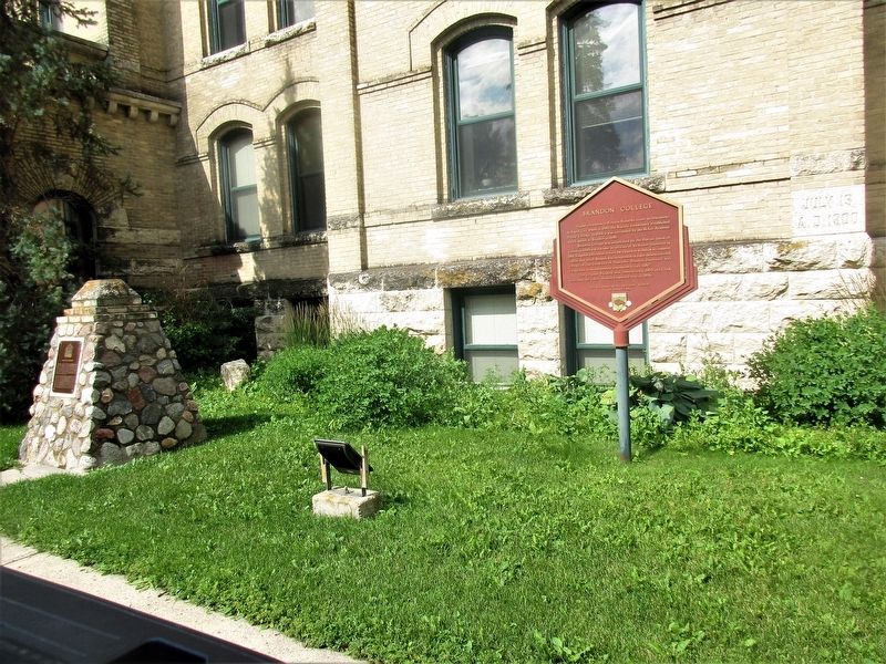
Higher Education in Western Manitoba traces its beginnings to Rapid city where in 1880 the Baptist community established Prairie College. In 1884 it was succeeded by the McKee Academy which moved to Brandon in 1890.
Brandon College was . . . — — Map (db m204698) HM
Brandon Courthouse and Gaol
Brandon's importance as a major centre in southwestern
Manitoba was confirmed when it was selected in 1883 as
the headquarters for the newly created Western Judicial
District of Manitoba. The Brandon . . . — — Map (db m289837) HM
The Burchill & Howey Block was constructed in 1906 and designed by notable Brandon architect, W.A. Elliott. The main floor of the structure was originally used by its owners as a retail butcher shop until 1945 when the property was sold to the . . . — — Map (db m290251) HM
Designed by W. A. Elliot, one of Brandon’s most prominent architects, the Central Fire Station was built in 1911 and stands on the site of its 1882-1893 predecessor. Elliot’s youngest son, Egbert, proposed the addition of the Station’s Tower. The . . . — — Map (db m204876) HM
Brandon's first mayor, Thomas Mayne Daly, hired local architect firm McCoskie & Co. to design this house for him in 1882 during Brandon's first decade of settlement. Daly was also appointed as Canada's first Juvenile Court Judge in 1909. This . . . — — Map (db m204875) HM
[English] Former Merchants Bank Building The Merchants Bank opened its first Brandon office in 1882, shortly after the townsite was chosen. This building, designed by the Montreal architectural firm of Taylor, . . . — — Map (db m290283) HM
This house was built for George A. Paterson in 1893 by
Brandon's William Bell and Sons. 1039 Louise Avenue is a
splendid example of the Eastlake style of architecture, which
is characterized by an abundance of ornamentation produced by
the . . . — — Map (db m289840) HM
This cairn is faced with stone from the walls of Prairie College, the forerunner to Brandon College and Brandon University. It was constructed in 1999, Brandon University's Centennial Year. Prairie College was the first post-secondary educational . . . — — Map (db m204700) HM
[English] Born near London, Upper Canada, Sifton as lawyer, politician, businessman and principal owner of the influential Manitoba Free Press, had great impact on Canadian development. As a member of the Manitoba Cabinet, he . . . — — Map (db m200468) HM
In 1881 Thomas Mayne Daly arrived in Manitoba from his native town of Stradford, Ontario and began his distinguished legal and political career in Brandon.
Elected the first Mayor of Brandon in 1882, Daly actively promoted civic development in . . . — — Map (db m204701) HM
This monument is erected
on the site of the Ukrainian
Catholic Church built in 1904
by Ukrainian pioneers
Moved to Beausejour in
1979 as a historical museum
To commemorate those who
had faith, wisdom and courage
to leave . . . — — Map (db m204539) HM
The Saints Peter & Paul Parish Community remembers and honors the ancestors who not only brought faith to this community some 100 years ago, but through their daily example showed us that we could live in harmony with our neighbours and the . . . — — Map (db m203648) HM
Named as a postal district May 16, 1938
The R.M. of Brokenhead in their
Centennial honours the Postmasters who
served the residents of this neighbourhood.
John Dehn 1938-1947
Fred Klann 1947-1948
Rudolph Ferchoff 1948-1949 . . . — — Map (db m203574) HM
Dauphin Railway Station
Railway service became essential as Manitoba was opened to
settlement and agricultural commerce during the 1880s and 1890s.
In one of the province's greatest waves of construction, first the
Canadian . . . — — Map (db m289845) HM
Built between 1936 and 1939, the Church of the Resurrection is a proud testament to the cultural and spiritual strength of Ukrainian settlers in the Dauphin area. This "prairie cathedral" was designed by one of the early builders of . . . — — Map (db m229428) HM
First Railway in Western Canada
On December 3, 1878, the last spike was driven here to complete the first railway line built in the Canadian West. Known
as the Pembina Branch, it ran some 100 kilometres from St. Boniface to . . . — — Map (db m301874) HM
This is an original size reproduction of Manitoba's biggest sturgeon. Weight 406 lbs. Length 15 1/2 feet. Age 150 years. A female, full of caviar. This record sturgeon was taken out of the Roseau River east of Dominion City by Sandy Waddell, October . . . — — Map (db m301875) HM
This splendid example of a small Neo-Classical style
municipal building was designed by the Winnipeg architect
John D. Atchison. Erected during 1917-18 by general contractors
Grey and Davidson, it remains one of the outstanding buildings . . . — — Map (db m288747) HM
Established in 1872, Fort Dufferin was essential to events asserting Canada's
sovereignty over Manitoba and the North-West Territories. The complex
was initially the headquarters for the British-Canadian contingent of the
North . . . — — Map (db m306577) HM
After 1790 the junction of the Red and Pembina
Rivers was the site of fur-trading posts of the Hudson's
Bay Co., North-West Co., and XY Co. Here at Fort Daer
the early Selkirk Settlers hunted buffalo when food was
scarce at the Red River . . . — — Map (db m288748) HM
The March West
In June 1874 the newly-formed North-West Mounted
Police assembled here at Fort Dufferin, the Canadian
headquarters of the International Boundary Commission.
On 8 July the force set out on its famous "March . . . — — Map (db m306575) HM
New Iceland represents a distinctive episode in the early settlement of the Canadian West. In 1875 and 1876, more than a thousand Icelandic immigrants settled a large tract of land reserved for them by the federal government along the western shore . . . — — Map (db m8453) HM
A Memorial to the Fallen
A Reminder to the Living
1914 - 1918
1939 - 1945
Honour Roll 1914 - 1918
King A. · Lavoie J. · McLeod G. · Smith J.L. · Sinclair A.G. · Wellman W.
Honour Roll 1939 - 1945
Cedarland H.W. · David . . . — — Map (db m203817) WM
At the going down of the sun and in the morning, we will remember them.
Honor Roll 1914 - 1918
Cook A.H. · King A. · Lavoie J. · McLeod G. · Sinclair A.G. · Smith J.L. · Wellman W.
Honor Roll 1939 - 1945
Blank E. · Brezino J. · . . . — — Map (db m203713) WM
This cairn is dedicated to St Mary's (Polish) Catholic Church of the Brightstone area 1914 - 1988. The bell in this cairn is from that church. Erected in 1991 by The Knights of Columbus Lac du Bonnet Council, No. — — Map (db m204379) HM
Plaque#1
Winnipeg River
The existence of the Winnipeg River dates back to the melting of the last great ice sheet 12,000 years ago and the formation of Lake Agassiz. Originating from Lake of the Woods, the river divides the Boreal . . . — — Map (db m204207) HM
The Allegra Church was built in 1936.
Father John Zimmerman blessed the
Church in 1938, and at Christmas
celebrated the first Mass.
In 1940 Father Charles Litowski was
assigned to the parish and was the
paster at Allegra until his death in . . . — — Map (db m203707) HM
St John the Baptist Ukrainian Catholic Church
Built 1945
First Mass April 23, 1946
by Very Rev. Msgr. Joseph Cormylo
This cairn is dedicated to the Ukrainian
pioneers of Lowland for their religious
beliefs and strong sense of . . . — — Map (db m204540) HM
First Airmail Flight in Manitoba June 1, 1927 -Oct. 4, 1927
The first semi-official airmail in Manitoba was carried from this site to Bissett, Wadhope, and Slate Lake return by Capt. F. J. Stevenson of Western Canada Airways Limited on 1 . . . — — Map (db m203816) HM
Binscarth Colony Farm, named after a farm in Orkney, was
situated on S.E. 1/4 35-19-28. It was established in 1882 by
G.L. Smellie.
Land was purchased in 1881 by the Scottish Ontario and
Manitoba Land Company. This colony farm was . . . — — Map (db m306678) HM
The site for the Anglican Church was selected in 1896
Work on the Church was started in 1897 and the first
recorded vestry meeting was held in April, 1898. The chancel and tower were erected in 1910.
In 1926, the grounds were further . . . — — Map (db m306677) HM
In about 1880 homesteaders began settling in the area. The first
settler to come into the territory was William Denmark, who settled
a homestead north of the present town. The late Col. C. A. Boulton
settled a homestead some 10 miles further . . . — — Map (db m306676) HM
Here ran the original west boundary of the
Province of Manitoba. On July 15, 1870 Manitoba officially
became a Canadian province. It then measured about
130 miles east to west and 110 miles north to south, with
an area of 13,928 square miles. . . . — — Map (db m306545) HM
Beautiful Plains County Court Building
The need for public buildings such as court houses and town halls accompanied the settlement of Western Canada. A town's future as the administrative centre for a newly settled region could . . . — — Map (db m288756) HM
During the Manitoba land boom of the late 1870s and
early 1880s settlers from Ontario were attracted to the Beautiful
Plains area. The town of Neepawa was incorporated in 1883 and
became the county seat the following year. The County . . . — — Map (db m288755) HM
The open landscape close to the CPR main line made this site attractive for summer training camps for artillery, infantry, and cavalry units. Established as Sewell Camp in 1909, it was renamed in honour of Major-General Sir Sam Hughes, . . . — — Map (db m218701) HM
Established in 1909, Camp Sewell (renamed Camp Hughes in August 1915) opened on a war-time footing in 1915. Compared to the summer of 1914 when almost 7,000 militia soldiers trained, camp strength more than doubled to 15,000 soldiers. A . . . — — Map (db m218681) HM
[English] Named after Sir Sam Hughes, Minister of Militia and Defence (1911–1916), this site contains the most intact First World War battlefield terrain created for training purposes in Canada. One of a dwindling number worldwide, . . . — — Map (db m218700) HM
[English] Camp Hughes, originally named Camp Sewell, was established in 1909 as the Central Training Camp for Military District 10 (Manitoba, Saskatchewan, North-West Territory and N.W. Ontario). The terrain was selected for its . . . — — Map (db m218702) HM
[English] Sewell Station was located on the Canadian Pacific Railway line. In 1881, the CPR had reached a point between Carberry and Douglas approximately seven miles east of Douglas. The Railway laid sidings at Sewell (later known . . . — — Map (db m218698) HM
[English]
During the Great War, Camp Hughes became the 2nd Largest “city” in Manitoba, second only to Winnipeg. By 1916, the camp was divided into five brigade areas: Central; South Central; West; North-East and South-East Camps. . . . — — Map (db m218708) HM
[English] The area immediately south of the main rail line and sidings was established as a headquarters and administrative support area. It contained several wood frame structures including the Commandant's Hut (and Staff Lines), . . . — — Map (db m218699) HM
[English] The Canadian Army Medical Corps, Military District 10, established at Camp Hughes in 1915, a Field Ambulance Depot to raise volunteers for overseas service. As well, a hospital at the Camp was set up consisting of 250 . . . — — Map (db m218704) HM
[English]
To the north-west of the Canadian Pacific Railway station lies a large, flat expanse of land. It was here that parades of the camp garrison, comprising up to 30,000 troops took place. Revues of note occurred in 1915 . . . — — Map (db m218697) HM
[English] When not training soldiers had many opportunities and venues within the Camp to keep themselves occupied. The YMCA and the Knights of Columbus maintained large marquee tents where the men could read books and newspapers, . . . — — Map (db m218684) HM
[English] During the Great War, training at Camp Hughes emphasised basic infantry soldiering where the new recruit learned drill, weapons handling, manoeuvre and tactics. In addition certain specialties were instructed. Signalers . . . — — Map (db m218707) HM
[English] The Camp Hughes trench system was developed in 1915/1916 to teach recruit soldiers the lessons of trench warfare which had been learned through great sacrifice on the battlefields of France and Flanders. Seasoned veterans . . . — — Map (db m218705) HM
[English] An internationally renowned writer, artist, and social reformer, Seton was passionately interested in nature and the relationship of Native peoples to their environment. His realistic animal stories were best-sellers that . . . — — Map (db m201689) HM
Postage Stamp Province
Here ran the original east boundary of the Province of Manitoba. On July 15, 1870 Manitoba officially became a Canadian province. It then measured about
130 miles east to west and 110 miles north to south, . . . — — Map (db m288820) HM
[English] Designed under the direction of Thomas Fuller, chief architect for the Department of Public Works from 1881 to 1896, this structure was built in 1895-1898. The federal presence was extended across Canada by public . . . — — Map (db m200606) HM
Elevator Five - The Paterson Elevator
The Paterson Elevator was one of the four original elevators in the community of Inglis in 1922. Typical of thousands of Standard Plan elevators built on the prairies in the golden age of the . . . — — Map (db m306671) HM
This impressive grouping of five standard-plan wooden grain elevators is a rare survivor of the long rows that once dominated Prairie towns. The row was built between 1922 and 1941, Manitoba's golden age of elevators, by a cross-section . . . — — Map (db m8491) HM
Inglis Grain Elevators
The grain elevator, once the most striking built feature of
Manitoba's rural landscape, was introduced in the 1880s. It created
a more efficient method of grain handling than the previous process
of . . . — — Map (db m288854) HM
The Reliance Grain Company
The Murphy Foundation
Gabriel B. Murphy was a successful grain and livestock farmer near
Carberry, Manitoba before forming the G.B. Murphy Company in 1903.
After acquiring several . . . — — Map (db m306674) HM
Pres de cet endroit s'élevait le Fort Maurepas, un des
postes de commerce de la Verendrye. La compagnie de la
Baie d'Hudson et la Compagnie
du Nord Ouest s'établirent
ici en 1792. Le Fort Alexander,
construit par la compagnie de
la . . . — — Map (db m204282) HM
The plaque is erected
in memory of the men
of Abitibi Power & Paper
Company Limited and
subsidiary companies
who gave their lives in
the Second World War
1939 – 1945
G.H. Anderson
R.H. Betts
J. Boyd
B.E. Columbus
J.F. Cooper
G.S. . . . — — Map (db m204328) WM
Erected between 1852 and 1854, this large limestone dwelling housed the rector of nearby St. Andrew’s church and complemented the massive construction of that building. The rectory, built for the Reverend William Cockran was one of the . . . — — Map (db m8449) HM
Beginning in 1828 the Rev. W. Cockran held religious services in the homes of settlers in this area. In 1829 he established a permanent residence at Grand Rapids on the Red River and by 1831 had built a small wooden church. His growing congregation . . . — — Map (db m8445) HM
Built in the mid-1850s, this house was the residence for a private girls’ school run by Matilda Davis until 1873. The school was supported by families of the Red River Settlement and by officers of the Hudson’s Bay Company from across . . . — — Map (db m8450) HM
The Assiniboine River, chief tributary of the Red River which it joins in the City of Winnipeg, takes its name from the Assiniboine Indians through whose hunting grounds it flowed. The river rises in the Province of Saskatchewan and is approximately . . . — — Map (db m288757) HM
A Sioux Indian chief wished to marry the beautiful daughter of an Assiniboine chief. The Assiniboine, however, gave his daughter's hand to a Cree chief with whom she was in love because the Cree offered a rare snow-white horse as a gift. The angry . . . — — Map (db m306568) HM
In the early years fire was an ever-present danger both in town and on the farms. The old newspapers are full of accounts of fires started from lamps and heated stovepipes. These fires were very difficult to control because of lack of available . . . — — Map (db m200584) HM
This is the only Caméré curtain bridge-dam built in North America, and by far the largest ever constructed. H.E .Vautelet, the Canadian engineer responsible for its design, adapted a French technological advancement to deal with the . . . — — Map (db m9205) HM
Born at Melbost, parish of Stornoway, in the Scottish Hebrides.
Duncan McRae joined the Hudson's Bay Company as a stonemason
in 1837 and worked for the company in the Red River Settlement
for the next five years. He assisted with the construction . . . — — Map (db m288760) HM
The first marker of the Dominion Lands Survey was placed 10 July, 1871, on the Principal Meridian, about half a mile south of this site. The system, then inaugurated by Lieutenant Colonel J.S. Dennis, Surveyor-General, extends across the prairies . . . — — Map (db m8489) HM
St Michael's Ukrainian Orthodox Church
St. Michael's Orthodox Church, consecrated October 14, 1899,
was the first permanent Ukrainian church erected in Canada. Until the
parish joined the Greek-Orthodox Church of Canada in . . . — — Map (db m296627) HM
Constructed in 1899, this church is a fine early example of Ukrainian ecclesiastical architecture in Canada. Its distinctive massing, plan and bulbous cupolas reflect the Byzantine-influenced architectural heritage of the homeland of the . . . — — Map (db m8421) HM
Municipal Building and Auditorium
Acclaimed by Virden's The Empire-Advance as one
the finest and best equipped opera houses in Western
Canada, the Auditorium has a handsome interior and
superb acoustics. It was . . . — — Map (db m302697) HM
Past Originally known as Gopher Creek, had its first Post Office established in 1883, and with the continual growth of the C.P.R. westward, soon became a thriving town. The first oil well of the Daly Field of Virden was successfully . . . — — Map (db m303400) HM
This plaque commemorates the production of the fifty-millionth barrel of crude oil from Manitoba oil fields, and stands as a perpetual tribute to the community and to all in the oil industry who over the years developed this great natural resource . . . — — Map (db m200592) HM
This pump jack is located over an original oil well at Surface Location: 06 22 10 26 W1M The Regent Drill company drilled the well for the Murphy Oil Co. Ltd. The hole was spudded in on March 29, 1955 The rig was released on April 9, 1955 and the . . . — — Map (db m200587) HM
Erected by the Citizens of Elkhorn and district in memory of those who fell in the great war
1914 - 1918
They Gave Their All
1938 - 1945
Brennand G. •
Duxbury T. •
Duke A.S. •
Jenner J. •
McDonald J. •
Mallett R. • . . . — — Map (db m204710) WM
[English] When A.C. (Ace) Emmett arrived in 1902, Manitoba had only a few passable roads. Railways provided the chief means of mass transportation. Most automobile owners were concentrated in Winnipeg. Emmett energetically led the . . . — — Map (db m200618) HM
Although Lake Manitoba was named lac des Prairies in 1738 by
La Verendrye, the Indians knew these waters from time immemorial
as the "narrows of the Great Spirit" (in Cree Manito bau). In stormy
weather waves crashing on the limestone rocks of . . . — — Map (db m288751) HM
To accommodate the increasing population of Red River Settlement, Reverend David Jones of the Church Missionary Society built a second Anglican church here at Image Plain. It opened for worship on 30 January 1825, with a congregation of mixed races . . . — — Map (db m288753) HM
1818-1825 First ChapelWhen the first two Catholic missionaries arrived at the Red River settlement, much work awaited them. Father Provencher constructed a modest log structure to serve as rectory, church and boys' school. 1825-1839 Second . . . — — Map (db m106491) HM
Over the course of his lifetime, Hartley T. Richardson has been an outstanding leader in business, volunteerism, and philanthropy, and a passionate advocate for Winnipeg and Manitoba.
His dedication to our community includes a deep affection . . . — — Map (db m290929) HM
Order of Manitoba
Lieutenant Governor Janice C. Filmon, C.M., O.M. celebrated the recipients of the Order of Manitoba with the gifting of more than 70 trees to Assiniboine Park during Canada's 150.
A blend of alder, birch and . . . — — Map (db m290930) HM
[English] Born in the Red River Settlement, Ambroise-Didyme Lépine engaged in river-lot agriculture, combining this with hunting and trading as did many other Métis. In the autumn of 1869 he became Adjutant General to Louis Riel and . . . — — Map (db m220224) HM
Bonnycastle Park is named for Richard H.G. Bonnycastle, who served as the first Chairman of the Metropolitan Corporation of Greater Winnipeg from 1960-1966. Developed on the former site of the Metro Transit Garage, the park was officially opened in . . . — — Map (db m220491) HM
[English]
Amelia Yeomans was one of Winnipeg's first women medical practitioners. She led the early crusades both for temperance and women's suffrage. Born in Lower Canada, she obtained her medical degree at Michigan State . . . — — Map (db m220700) HM
[English] This road was formerly part of a cart trail, also known as the Carlton, Saskatchewan or Fort Ellice Trail, which extended 1,400 kilometres between Fort Garry and Fort Edmonton. It was the principal overland trade route in . . . — — Map (db m220204) HM
Government House is the official residence of the Lieutenant-Governor of Manitoba. The present structure was completed by the Dominion Government in 1883 and transferred to Manitoba's jurisdiction in 1885 symbolizing the completion of Manitoba's . . . — — Map (db m220672) HM
[English] A native of Trois-Rivières, soldier, trader and explorer, La Vérendrye founded the first white settlements on the Canadian Prairies. Between 1731 and 1743 he and his sons established several posts beyond Lake Superior . . . — — Map (db m220128) HM
The Fort Garry is a classic hotel embodying the only example of the famed Gothic Chateau design in Manitoba. Built by the Grand Trunk Pacific Railway, it officially welcomed its first guests in December of 1913. The Fort Garry has traditionally been . . . — — Map (db m220399) HM
[English] Built between 1911 and 1913 according to plans drawn by architects George A. Ross and David H. MacFarlane, this hotel was one of a series constructed by Canadian railways in what is known as the Château style. The Fort . . . — — Map (db m220398) HM
[English] Near this side stood the following Forts: Fort Rouge, under La Vérendrye, 1738; Fort Gibraltar, of the North West Company, 1810, became Fort Garry of the Hudson’s Bay Company, 1822; replaced by Upper Fort Garry, of stone, . . . — — Map (db m220450) HM
The first Knox Church was located at the corner of Fort Street and Portage Avenue in the Village of Winnipeg. It was built in 1868. It was a place of worship for those of the Presbyterian faith. Many of its members were descendants of the Lord . . . — — Map (db m220677) HM
Signatory to treaty #6 Ka-Payak-Waskunam 1810-1886 Chief One Arrow, chief of a Willow Cree Tribe along the Saskatchewan River, was incarcerated at Stony Mountain for his participation in the North-West Rebellion of 1885. He was released . . . — — Map (db m219001) HM
1736[Français] Le 6 juin, dans une île du lac des Bois furent tués, le Père Aulneau, s.j., 31 ans, J.-B. La Vérendrye, 22 ans, et leurs 19 compagnons, précurseurs de nombreux missionnaires et des voyageurs qui . . . — — Map (db m219199) HM
[Français] Erigée à la fin des années 1840, cette maison a servi de premier couvent aux Sœurs Grises qui y firent de l’enseignement et dispensèrent des soins aux malades, aux orphelins et aux vieillards. Première institution de . . . — — Map (db m219200) HM
[Français] En 1829, les soeurs métisses Angélique (1787-1869) et Marguerite (1780-1878) Nolin ont ouvert la première école officielle pour jeunes filles dans l'Ouest canadien, à la Rivière-Rouge. L'école était située au nord-est de . . . — — Map (db m218997) HM
[English] On the occasion of the canonization of Sister Marguerite d’Youville the first Canadian born saint and foundress of the Order of the Sisters of Charity of Montreal, the city of Winnipeg honours the Grey Nuns. From the time . . . — — Map (db m218998) HM
[English] This labour leader and politician fought for the interests of workers and advocated on behalf of the Jewish community. One of the more moderate leaders of the Winnipeg General Strike of 1919, Heaps pushed . . . — — Map (db m214599) HM
Near this spot on December 12th, 1886, the Salvation Army held its first meeting west of the Great Lakes ————————— [100th Anniversary Plaque] This commemorative plaque was unveiled October 10, 1986 by ☆ ☆ ☆ . . . — — Map (db m215696) HM
Founder of Modern Astronomy Presented by The Canadian-Polish Community of Manitoba on the occasion of the 500th anniversary of his birth Nicolaus Copernicus Observance Committee Inc. of Manitoba Odkrywca Nowóczesnej Astronomii . . . — — Map (db m215400) HM
Designed in less than a month by Winnipeg architects Barber and Barber, this edifice was constructed amidst a storm of scandal and controversy. Considered beautiful by some, ugly by others, it was the focus of many civic events, the “Gingerbread” . . . — — Map (db m215600) HM
This granite boulder brought from Glacial Lake Agassiz commemorates the centenary of the institution which is now the University of Winnipeg and the following important events in its history 1871 Manitoba College founded in Kildonan by the . . . — — Map (db m291367) HM
156 entries matched your criteria. The first 100 are listed above. The final 56 ⊳