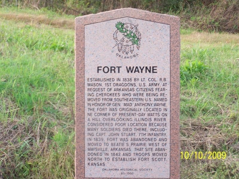
Established in 1838 by Lt. Col. R.B. Mason, 1st Dragoons, U.S. Army, at request of Arkansas citizens fearing Cherokees who were being removed from southeastern U.S. Named in honor of Gen. "Mad" Anthony Wayne, the fort was originally located in NE . . . — — Map (db m181594) HM
The Confederate Encampment here at Middle (or Muddy) Boggy Crossing on the Boggy Depot Road held by Lieut. Col. John Jumper's Seminole Battalion, Capt. Adam Nail's Company A of First Choctaw and Chickasaw Cavalry and a detachment of the Twentieth . . . — — Map (db m244746) HM
Near this place on Aug. 5, 1932, Atoka County Sheriff C.G. Maxwell and Deputy Sheriff Eugene Moore were involved in a shoot-out with Clyde Barrow, Raymond Hamilton, and Everett Milligan. The incident occurred when the two lawmen tried to arrest the . . . — — Map (db m64070) HM
You are now entering old ”No Man’s Land”
Colorado/Kansas • 37th Parallel Texas State Line • 36° 30’ parallel New Mexico • 103rd Meridian Cherokee Outlet • 100th Meridian
Called “No Man’s Land” until 1890 Known then . . . — — Map (db m131421) HM
Armstrong Academy, established by Choctaw Nation and named for Wm. Armstrong, Indian Agt., was opened in 1845. Rev. R.D. Potts, Supt., under Baptist Miss. Soc. Post Office established Nov., 1850. Confederate Capitol during Civil War. Choctaw . . . — — Map (db m77938) HM
During the late 1830s and early 1840s, Chickasaw Indians removed by the United States Government from Alabama and Mississippi passed near here on their way to a new home in present-day south-central Oklahoma. In 1837 alone, an estimated 6,000 . . . — — Map (db m77936) HM
Site selected and named 1842, by Gen. Zachary Taylor, later Pres. of U.S. Fort established 1842 by 2nd Dragoons, occupied by several rifle, infantry, cavalry, and artillery companies. Built to protect the Chickasaw and Choctaw Indians from the . . . — — Map (db m81743) HM
"Kind and sympathetic by nature, generous to a fault, he was an honest man of noble impulses, and born and bred a gentleman." These were the words of a contemporary of General Douglas Hancock Cooper, C.S.A.
Cooper was appointed U.S. Agent to . . . — — Map (db m77935) HM
Butterfield Overland Mail site of Nail's CrossingHere was located a stage stand of the Butterfield Overland Mail route, under act of Congress, March 3, 1857. First mail service arrived here in September 1858, enroute to San Francisco, service . . . — — Map (db m40707) HM
This school opened at the Indian agency on Sugar Creek with 8 pupils. A new building was erected as a boarding school in 1872, for Wichita and Caddo children. Fire in 1878 destroyed the school. It soon reopened in a new building here on the Washita . . . — — Map (db m166713) HM
U.S. troops encamped near Cheyenne Agency in Indian uprising 1874. Site s.w. of agency selected by Agt. J.D. Miles and Capt T. Wint, established as permanent post in July, 1875, and named for Gen. Jesse L. Reno who died in action in Battle of . . . — — Map (db m39808) HM
Production of crude oil from the newly-discovered Healdton field surrounding this marker site flooded the marker with an oversupply of petroleum protesting that pipeline purchases were inadequate. Producers claimed they were being deprived of . . . — — Map (db m180600) HM
Established July, 1837, Rev. S.A. Worcester, Supt. Over 25 million pages were printed in Indian languages and in English by 1861. Printers and translators were John F. Wheeler, John W. Candy, Edwin Archer, Stephen Foreman. Near site are graves of . . . — — Map (db m52755) HM
First Annual Indian Mission Conference of the Methodist Church was held in Oklahoma at Riley's Chapel, Oct. 23, 1844, Bishop Thomas A. Morris presiding. Conference area was west to the Rocky Mts., east to Ark.-Mo. line. Rev. Thomas Bertholf, . . . — — Map (db m52757) HM
This site is at the north end of Main Street, called "Commercial Row," in this town begun in 1831. Name of nearby post office, "Fort Towson," was changed to Doaksville on Nov. 11, 1847. — — Map (db m52564) HM
Established May, 1824, under command of Col. Matthew Arbuckle to guard this region of Spanish border. Headquarters of Gen. S.B. Maxey, U.S. Army. Abandoned at end of Civil War. In the vicinity, Doaksville was important trading center and one time . . . — — Map (db m52576) HM
The Fort Towson Landing was south of here on the banks of the Red River. Also known as the Public Landing, from 1824 to 1854 it served as a receiving point for soldiers and supplies delivered by keelboats and steamboats. Traders from the Choctaw . . . — — Map (db m52578) HM
Here at Doaksville, June 23, 1865, Brigadier General Stand Watie, Cherokee Indian, was the last Confederate General to surrender. — — Map (db m151958) HM
During the early 1800's, present Southeastern Oklahoma was a major transportation crossroads. Roads connected Fort Towson in the Choctaw Nation to military installations to the North, South and West. On the Texas side of the Red River, Jonesboro was . . . — — Map (db m52580) HM
Begun 1848 by Rev. John Lathrop of American Bd. of Foreign Miss. Rev. O.P. Stark, Supt. (1850), built 1st church. Mrs. Stark opened 1st school here. Others in the service through 100 years include W.J.B. Lloyd, J.P. Gibbons, Bella M. Gibbons, Silas . . . — — Map (db m160362) HM
Noted school for boys, established by Choctaw Nation 1841; named for John C. Spencer, U.S. Sec. of War. Students who were later prominent leaders included Coleman E. Nelson, Allen Wright, Jackson McCurtain, Charles S. Vinson, B. F. Smallwood, . . . — — Map (db m147475) HM
Established in May 1865, by Kit Carson, hero of Valverde and Brig. Gen., New Mexico Volunteers, to guard Santa Fe Trail and furnish escorts for caravans engaged in Santa Fe trade. Santa Fe Trail crossed this highway here and was first traveled by . . . — — Map (db m39798) HM
Canadian River was south line of “Old Oklahoma” opened by Run at 12 o’clock noon, April 22, 1889. Riders started at river crossing near here. Many thousands entered the 2,000,000 a. tract north: homes were planted and tent cities . . . — — Map (db m144698) HM
Located 1 mi. S of here on Chisholm Cattle Trail, also called Arbuckle Cattle Trail, Blue hired Cherokees and Creeks to kill wild buffalo in early 1870s and to deliver the hides to Atoka for shipment east. — — Map (db m141848) HM
Kiowa Chief Stumbling Bear who signed the Medicine Lodge Treaty, 1867, founded the first permanent settlement on Canyon Creek, southwest of here. First Government-built houses for Indians were erected in the settlement, 1877. — — Map (db m108856) HM
At the opening of Kiowa-Comanche-Apache lands, the original townsite in old Comanche County was SW 1/4, T2S, R11W. The original name McKnight was rejected by the post office. The name Walter, for City Commissioner W.R. Walter, was then chosen Sept. . . . — — Map (db m119434) HM
Creek Indian "Chief" Sapulpa had a ranch, blacksmith shop and store here by 1850. Serving in Confed. Army, he was discharged a Lieut., and is buried N. of his old homestead in cemetery owned by Nancy Green Chap., NSDAR, 2 blks. S. Local RR station . . . — — Map (db m180760) HM
Established in autumn 1839 by Lt. Col. R.B. Mason and 1st Dragoons, U.S. Army, and named in honor of Gen. “Mad” Anthony Wayne. Abandoned on May 15, 1842. Here in July 1861 Col. Stand Watie established a Confederate army post and . . . — — Map (db m99747) HM
Stand Watie was only American Indian to attain rank of Brigadier General during Civil War and was last Confederate General to surrender. Born in Georgia, December 12, 1806. He spoke only the Cherokee language until he was twelve years of age. . . . — — Map (db m25557) HM
Near here on May 28, 1849, was the camp of a large party of gold seekers en route to California with a military escort under the command of Captain R. B. Marcy. The California Road was used by travelers for over 50 years. East of here about 4 miles . . . — — Map (db m39802) HM
Famous Civilian Indian Scout for the U.S. Army, was born in 1839 and died in 1925. He was one of the five survivors of the 1874 Buffalo Wallow Fight, and was awarded the Congressional Medal of Honor for his efforts. Chapman married a Cheyenne woman . . . — — Map (db m62310) HM
From this noted watering place came the name of "Bison," 1 mi. so., "Buffalo Springs" was the camp site of Pat Hennessey and his men just before they were massacred, 7 mi. so., July 4, 1874. Next day, a war band of Indians was stood off by ranchmen . . . — — Map (db m39801) HM
At the opening of "Old Oklahoma", April 22, 1889, this was the north line for the Run starting at 12 o'clock noon. Prairies and hills in the 2,000,000 acre tract, south, were peopled by tens of thousands, homes were planted and tent cities sprang up . . . — — Map (db m39796) HM
A Comanche band near the village was attacked by Capt. Earl Van Dorn, with 4 companies of 2nd Cavalry, Oct. 1, 1858. Unknown to him, the Indians were on way from friendly council with officers at Ft. Arbuckle. In the furious fight, 70 Indians were . . . — — Map (db m181528) HM
Wichita Village in Devil's Canyon was scene of 1st. meeting between the U.S. and Plains Indians in Oklahoma to promote peace, July 21, 1834. U.S. Dragoon Regiment under command of Col. Henry Dodge accompanied by other noted officers and civilians . . . — — Map (db m146590) HM
During the 1930s severe drought plagued the states in the Great Plains and deepened the Depression. High winds caused dust storms which blackened the sky. In 1934, President Franklin Roosevelt initiated a program to help stabilize the blowing soil . . . — — Map (db m39805) HM
Was located 3 miles east and 1/2 mile south of this marker. The school was formed in the spring of 1939 by a special election to consolidate the schools of Dryden, McKnight, Metcalf and Teacross. The first senior class was 1939 and the last class to . . . — — Map (db m160352) HM
Site of Civil War naval battle. Confederate Indian forces led by Brig. Gen. Stand Watie, forced aground and captured Union Steamboat J.R. Williams with cargo worth $120,000, on June 15, 1864. Southern troops included Choctaws, Chickasaws, Creeks and . . . — — Map (db m64073) HM
One of the earliest port towns and trading centers in Choctaw Nation, I.T. Choctaws brought from Mississippi up Arkansas River to Tamaha on steamboats as early as 1831. Tamaha developed as port and ferry crossing around 1836. Post office built 1884 . . . — — Map (db m76457) HM
Memorial to one of the earliest port towns and trading centers in the Choctaw Nation, I.T. Choctaws brought from Mississippi up Arkansas River to Tamaha on steamboats as early as 1831. Tamaha developed as port and ferry crossing around 1836. Post . . . — — Map (db m77875) HM
Est., 1834, by Lieut. T.H. Holmes, later Lt. Gen., C.S.A. This post was visited~June, 1834~by Gen. Henry Leavenworth on his expedition to the Plains tribes. Edwards' Store, site 1 mile west of here, was the last trading post until Santa Fe on the . . . — — Map (db m64074) HM
First newspaper printed in the Cherokee Strip, June 14, 1884. Published at tent town of Rock Falls, 2.5 miles N.W. of here by Capt. David L. Payne, leader of Oklahoma "Boomers". Printing office was burned and "Boomers" disbanded by U.S.
Troops, . . . — — Map (db m96589) HM
Academic, agricultural, vocational training for Indian youth from over U.S. Established by Act of Cong. 1882. Jasper M. Hadley 1st Superintendent. Handsome buildings of stone erected, and first pupils - Kiowa, Comanche children - entered Jan. . . . — — Map (db m60484) HM
"Hear me my Chiefs, I am tired. My heart is sick and sad. From where the sun now stands, I will fight no more forever."
With these words, Chief Joseph of the Nez Perce surrendered to Colonel Nelson A. Miles of the United States Army and thus . . . — — Map (db m60427) HM
Located 3 miles north. Was formed Mar. 17, 1920, by a special election vote to consolidate the districts of White Cap, Twilight, Wandell, and Bird Creek. The school graduated its first senior class in 1924 its last in 1968. It continued as a grade . . . — — Map (db m184804) HM
This was the U.S. Land Office site for filing claims at opening of "Old Oklahoma," April 22, 1889; also at opening of Cheyenne and Arapaho lands on April 19, 1892. J. C. Robberts was first Register, and J. V. Admire, first Receiver. First . . . — — Map (db m29318) HM
Founded by Congregationalists, this college – site one mile north, 1890- 1922, achieved renown in education and character-building.
It lives on at the University of Oklahoma as the Kingfisher College Chair of the Philosophy of Religion . . . — — Map (db m72993) HM
Established Sept., 1858, by four troops of crack 2nd Cav., under Major Earl Van Dorn. Named in memory of Lt. Charles Radziminski, a former member of the Regt. E. Kirby Smith, Cornelius Van Camp, Fitzhugh Lee, W. B. Royall all served there. Permanent . . . — — Map (db m119391) HM
This French Explorer, seeking trade with the Wichita Indians, came north from Louisiana, on August 25, 1719, he camped three miles east of Hartshorne and the next day, following Gains Creek, passed here on his way to the Canadian River and the . . . — — Map (db m29928) HM
"Warrior who perseveres" Born 1770 "Chief Moshulatubbee of Northern District, Choctaw Nation in Mississippi, received his name as a young warrior. He was dignified in bearing, of fine physique, steady and thoughtful in disposition. As Chief he . . . — — Map (db m190228) HM
On Sept. 1, 1863 Confederates under Brig. Gen. W.L. Cabell ambushed a Union force commanded by Maj. Gen. J.G. Blunt, but were driven off after a three hour battle. Later on July 24, 1864, the Choctaw Battalion led by Capt. Jack McCurtain defeated . . . — — Map (db m77951) HM
Building completed, and Maj. F.C. Armstrong was first agent in 1832. Village became known as Skullyville. Choctaw Nation adopted new constitution in convention here, 1857. Stage station for Overland Mail to San Francisco 1858-61. Leading Choctaws . . . — — Map (db m77871) HM
Established June 16, 1834, by 7th Inf., and named in honor of Gen. John Coffee of Tennessee. Abandoned by U.S. Army in November 1838. In 1842 site selected by Choctaw Council and established as Ft. Coffee Academy for Boys. During Civil War . . . — — Map (db m77873) HM
Skullyville was founded in 1832 while removal of Choctaws to what is now Oklahoma was in process. First Choctaw Agency in the West was established here with Major F.W. Armstrong as agent.
The name Skullyville was derived from Choctaw word . . . — — Map (db m64486) HM
James Francis Thorpe, Sac and Fox Indian name of Wa-Tho-Huck, "Bright Path". Born May 22, 1887, south of present-day Prague. Attended Haskell Indian School, Kansas and Carlisle Institute, Pennsylvania where he excelled in football and track. . . . — — Map (db m192980) HM
Established 1869 on reservation of Sac and Fox Indians who were moved here from Kansas. Reservation land allotted tribal members and surplus opened to White settlement in 1891. Noted members of the tribe include Chief Moses Keokuk, Dr. William . . . — — Map (db m41860) HM
Named for Gen. Henry Leavenworth who died near here July 21, 1834 while enroute from Ft. Gibson to Wichita Village in western Oklahoma for a peace conference with the Plains Indians. The expedition continued under Col. Henry Dodge, assisted by many . . . — — Map (db m141412) HM
On Sept. 18, 1864, a Confederate force of 2,000, mainly Gen. Stand Watie's Indian Brigade, intercepted a Union supply train enroute from Kansas to Ft. Gibson. The convoy of 130 wagons with supplies worth $1.5 million was captured after a heavy . . . — — Map (db m68101) HM
Crossed here: Ft. Gibson (Est. 1824) to Ft. Leavenworth. Two Cabin Creek battles in Civil War fought at old ford 5 mi.; S.W. Ketchum is east 1.5 mi. The first store, 1860, and a stage stand were at Old Sulphur Springs campground near here, N.E. . . . — — Map (db m52553) HM
Federal troops suddenly attacked a Confederate camp along the ridge near here at dawn, July 2, 1862. The surprised Confederates hardly returned fire before their officers and heavy supplies were captured. Yet hot fighting in the woods lasted all day. — — Map (db m52269) HM
On Sept. 18, 1864, a Confederate force of 2,000, mainly Gen. Stand Watie's Indian Brigade, intercepted a Union supply train enroute from Kansas to Ft. Gibson. The convoy of 130 wagons with supplies worth $1.5 millions was captured after a heavy . . . — — Map (db m141944) HM
Oldest permanent American settlement in the state. Grew out of Chouteau's fur trade at St. Louis, with Osages after they settled this region in 1802 from Missouri. Improvements here in 1817 became residence of Col. A.P. Chouteau, West Point grad. . . . — — Map (db m64481) HM
Caravans of gold seekers in the Rush for California traveled this Trail in spring, 1849, under military escort commanded by Capt. R.B. Marcy. Route lay west from Ft. Smith, south side of Arkansas and Canadian rivers, across Oklahoma. Camp ground . . . — — Map (db m144810) HM
Cut from Washington, Ark., to Fort Towson in 1831 for removal of Choctaws from Miss., became known as Choctaw Trail of Tears after thousands of suffering Indians used it to reach new lands. Road served as major east-west artery for Choctaw Nation . . . — — Map (db m24398) HM
Small cemetery nearby contains graves of Choctaw chief Samuel Garland (1862 – 64) and family members including his mother-in-law, Sophie Pitchlynn. Peter Pitchlynn, son of Sophie and John Pitchlynn, was chief 1864 -- 66. Garland migrated from . . . — — Map (db m24400) HM
Original Hochatown was 5 miles east. The church and cemetery relocated during construction of Broken Bow Lake in 1965. Pre-historic hunters left spear points along the river 6000 B.C. Caddo Indians occupied this land from 1000 A.D. to 1791 A.D. . . . — — Map (db m193881) HM
To the southwest near Red River stood Miller Courthouse, county seat of Old Miller County, Arkansas Territory 1820-1828. First post office established there Sept. 7, 1824, J. H. Fowler, postmaster. Claiborne Wright, prominent settlement leader, . . . — — Map (db m147470) HM
Many absentee Shawnee Indians migrated to this region from old Northwest Territory in early 1800’s settled and opened farms. A settlement of over 200 residents in vicinity became known as Shawneetown. Shawnees removed when land ceded to Choctaws in . . . — — Map (db m147476) HM
Nearby Alikchi Springs was site of court ground for Apukshunnubbee District, Choctaw Nation, 1838-1906. Justice dispensed here for major crimes committed by Choctaws, including capital punishment. Last legal execution under Choctaw law carried out . . . — — Map (db m145581) HM
Water powered grist mill in operation on Clear Creek early as 1819 by white settlers in old Miller County, Arkansas Territory. New mill built in 1837 by Choctaw Joel Kemp. A later owner, Choctaw John Wilson, replaced crude undershot wheel with . . . — — Map (db m24401) HM
Established here in 1869 as Oak Hill Industrial Academy by Presbyterian Board of Missions as boarding school for children of Choctaw Freedmen. Academy succeeded small school begun in 1860 by ex-slave and Presbyterian Minister Charles W. Stewart to . . . — — Map (db m24403) HM
Birthplace: 2½ miles N.E., 1873
Creek Poet: "Dew and the Bird," "Ode to Sequoyah," and other poems. Columnist: famous "Fus Fixico" letters. Editor, "Muskogee Times" and Eufaula "Indian Journal." Supt. of Creek Orphan School; in charge of . . . — — Map (db m73198) HM
Greatest ceremonial rite of Creek Indians was Green Corn Dance. It was held at time of year when before corn had fully matured and while grains were soft. Dance was celebration of harvest season and was of intense religious devotion.
In . . . — — Map (db m64184) HM
Formerly a strong southerly bend in the Canadian River was located here. The course of the river was permanently changed after the construction of the Lake Eufaula Dam in 1964. It is thought that the bend is named for Cole Younger who served in the . . . — — Map (db m146401) HM
"We here highly resolve that these dead shall not have fallen in vain" This commemorative marker is dedicated to the memory of the Union soldiers who bravely fought and died here on July 17, 1863. Major General James G. Blunt began moving 3,000 . . . — — Map (db m52288) HM
Springs in this area were first used by wildlife, Indians, and cattlemen. In 1902, Sulphur Springs Reservation was founded, renamed Platt Nat'l Park in 1906, and became part of Chickasaw Nat'l Rec. Area in 1976. The town was moved twice to its . . . — — Map (db m121633) HM
Site of Manard Settlement on Bayou Menard. Named for Pierre Menard (1766-1844. Menard, an early day fur trader, merchant and member of the Chouteau family. Served as the first territorial governor of Illinois.
Springs at Manard identified as a . . . — — Map (db m52605) HM
First peace council and alliance in Oklahoma between a European nation and Indian tribes held here at a Tawakoni village by Comdt Bernard De La Harpe on his first visit to the Arkansas River. He erected a post here carved with the coat-of-arms of . . . — — Map (db m77867) HM
Established Nov. 1861 by Gen. Albert Pike, C.S. Army. Named for Pres. Jefferson Davis, who had been stationed in the area when a Lieut. U.S. Army. Nearly one million dollares spent on this post by Confederates. In Second Federal Invasion Ft. Davis . . . — — Map (db m52277) HM
Muskogee Oil Refining Company, organized in March 1905, built a finishing plant near this site in November, 1904. It soon was producing lamp kerosene, lubricating oil and industrial fuel - the beginning of oil refining in Oklahoma, a leading . . . — — Map (db m73123) HM
Settled in 1829, named for Walter Webber, Western Cherokee Chief, who had a trading post here. Home of "Rich Joe" Vann to 1844, owner of "Lucy Walker," quarter mile race horse, for which he named his Mississippi River steamboat. In Civil War battle, . . . — — Map (db m52567) HM
The Otoes were prairie-dwellers and
Hunters. They migrated from the Lake
Michigan area to Iowa then to Nebraska
in 1700. The Missouria merged with the
Otoe Tribe in 1798. Removal to Indian
Territory (Oklahoma) began October 5
with arrival at . . . — — Map (db m200073) HM
Boley, Creek Nation, I.T., established as an all Black town on land of Creek Indian "Freedwoman" Abigail Barnett. Organized by T.M. Haynes first townsite manager. Named for J.B. Boley, white roadmaster, who convinced Fort Smith & Western Railroad . . . — — Map (db m234464) HM
Whether motorists called Route 66 the Ozark Trail, the Will Rogers Highway, Main Street America or the Mother Road, all remember Arcadia's Round Barn. The well-known landmark was built in 1898 by W.H. Odor.
After the route was designated a . . . — — Map (db m52003) HM
Near here, 1832, Washington Irving hunted wild horses, an exciting event described in his book on his Oklahoma tour as "Ringing the Wild Horse." In party were H. L. Ellsworth, U.S. Comm., Chas. J. Latrobe, English writer, and Swiss Count, Albert . . . — — Map (db m83097) HM
Two blocks N.E. Established by First Legislative Assembly on Dec. 24, 1890, as first Normal School in Oklahoma Ter. Opened Nov. 9, 1891. Richard Thatcher, 1st President, "The Edmond Sun" 1st issue July 18, 1889, leading paper for Territory, town and . . . — — Map (db m171165) HM
One of the first Oklahoma Official Centennial Projects was the preservation of Oklahoma Territory's first public schoolhouse, located in Edmond. It was originally built with funds raised by the Ladies School Aid Society under the leadership of Mrs. . . . — — Map (db m171168) HM
The Atchison, Topeka, and Santa Fe Railroad gave birth to Edmond, Oklahoma in terms of location and name on April 22, 1889. During road construction it was known as Mile 103 or "Summit," a side track stop on a high point (elev 1198 feet) of the . . . — — Map (db m171180) HM
Oklahoma City Oil and Gas Field Discovery Well brought in December 4, 1928, approximately six miles southeast of this marker.
From such beginning, sprawling Oklahoma City Oil and Gas Field became one of world's major oil producing areas, . . . — — Map (db m59947) HM
Oklahoma's rise to prominence as a leading producer of oil, natural gas and refined products can be attributed in great measure to the determination and hardy spirit of its pioneers in the industry.
These were the wildcatters, the roughnecks, . . . — — Map (db m172585) HM
At the opening of "Old Oklahoma" April 22, 1889, this was the East Line for the Run starting at 12 o'clock noon. Prairies and hills in the 2,000,000 acre tract, west, were peopled by tens of thousands, homes were planted and tent cities sprang up . . . — — Map (db m83092) HM
Erected 1878, Ward Coachman, Principal Chief. Creek Nation organized 1867 under written constitution, and Okmulgee named as capital. Noted Chiefs here included Samuel Checote, Joseph Perryman, Isparhecher, Pleasant Porter. “Okmulgee . . . — — Map (db m76561) HM
This noted Creek leader, b. 1819, Ala., had attended old Asbury Mission before he came to Ind. Ty. He was a Methodist preacher for 32 years until his death, 1884. He served as Lieut. Col. of First Regt. Creek Mounted Vols., C.S.A., during the Civil . . . — — Map (db m76604) HM
Symbolic of the impact oil had on the people of the Osage Indian Nation is the so-called "Million Dollar Elm." It was given this name because in its shade millions of dollars worth of Osage oil leases were auctioned. It was planted at this site . . . — — Map (db m83107) HM
One-half mi SW. Est. 1887 by St. Katharine Drexel and Bureau of Catholic Indian Missions, Washington, D.C. Original frame structure located near Main and Palmer burned in 1889, replaced here 1890 by a four-story stone building. Operated by . . . — — Map (db m55657) HM
Near this site on August 8, 1903, U.S. Deputy Marshal Wiley G. Haines, Chief of Osage Indian Police Warren Bennett, and Constable Henry Majors ended the career of the notorious outlaw gang known as the Martin brothers. The outlaws were wanted for . . . — — Map (db m52632) HM
This site, 3.5 miles N.W. is where Col. Jas. McIntosh, 2nd Ark. Mtd. Rifles, routed Loyal Union Indian forces, Dec. 26, 1861. The battle started with fire from the Indian line on Patriot's Hill, 2 Mi. S.W. The Loyal Indians finally fled into Kansas. — — Map (db m216344) HM
Established by Rev. John Murdock, under auspices of Friends Society, 1882. This noted school was attended by both Indian and white children. In this vicinity, was home of Wm. C. Rogers, last elected principle chief of Cherokee Nation, 1903 to 1917. . . . — — Map (db m7356) HM
The Coleman Theatre, built in 1929 as a vaudeville/movie theater palace, has hosted many legendary performers. Never closed, it holds the original Mighty Wurlitzer Pipe Organ that has entertained generations. Programs and acts of all types are . . . — — Map (db m80594) HM
139 entries matched your criteria. The first 100 are listed above. The final 39 ⊳