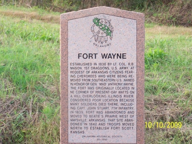
By Jason Armstrong, October 10, 2009
Fort Wayne Marker
| On U.S. 59 at Main Street, on the right when traveling south on U.S. 59. |
| On North Mississippi Avenue (U.S. 69) south of Ash Street, on the right when traveling south. |
| On U.S. 64 at N1680 Road, on the right when traveling east on U.S. 64. |
| On U.S. 70, 0.1 miles east of Ballpark Road, on the right when traveling west. |
| Near State Highway 199, 3.5 miles west of State Highway 78, on the right when traveling west. |
| On State Highway 199, 3.5 miles west of State Highway 78, on the left when traveling east. |
| Near State Highway 199, 3.5 miles west of State Highway 78, on the right when traveling west. |
| Near Nails Crossing Road, on the right when traveling west. |
| On U.S. 281, 0.1 miles north of Wichita Lane, on the right when traveling north. |
| On Business Interstate 40 east of Old U.S. 66, on the right when traveling west. |
| On East Main Street west of SE 5th Street, on the right when traveling west. |
| On South Muskogee Avenue (U.S. 62) 0.1 miles north of Crestwood Drive, on the right when traveling north. |
| On South Muskogee Avenue (U.S. 62) 0.1 miles north of Crestwood Drive, on the right when traveling north. |
| Near Red Road, 1.5 miles U.S. 70. |
| Near U.S. 70 west of State Route 209, on the right when traveling east. |
| On U.S. 70 east of State Route 209, on the right when traveling east. |
| Near Red Road, 1.5 miles north of U.S. 70. |
| On Fort Towson Historic Site Road (County Road E2060) 0.5 miles west of County Road N4375. |
| On North 4200 Road west of Old Spring Road, on the left when traveling west. |
| On U.S. 70 east of N4310 Road (State Route 147), on the right when traveling west. |
| On 325 Highway, 3.5 miles north of E0190 Road, on the left when traveling north. |
| On U.S. 77 at '89er Park Street, on the right when traveling north on U.S. 77. |
| On 48th Avenue Southeast at East Imhoff Road, on the right when traveling north on 48th Avenue Southeast. |
| On State Highway 58, 0.7 miles north of NW Wolf Road, on the right when traveling north. |
| On West Missouri Avenue (Oklahoma Route 5) west of North 9th Street, on the right when traveling east. |
| On East Taft Avenue (State Highway 117) east of South Division Street, on the left when traveling west. |
| On State Highway 20, 0.1 miles east of N470 Road, on the right when traveling east. |
| On County Road E 340, on the right when traveling west. |
| On State Highway 34 -, 0.5 miles north of Road N2050, on the right when traveling south. |
| On N2280 Road, 0.2 miles south of U.S. 270, on the right when traveling south. |
| On U.S. 81, 0.2 miles south of County Road E0550, on the right when traveling south. |
| On U.S. 81, 0.4 miles north of County Road E0590, on the right when traveling south. |
| On North Rush Avenue (Business U.S. 81) 0.1 miles north of Arapahoe Avenue, on the right when traveling north. |
| On U.S. 283, on the right when traveling south. |
| On Highway 283 at Road E1370, on the right when traveling north on Highway 283. |
| On Oklahoma Route 30 south of E1530 Road, on the right when traveling north. |
| On State Highway 9 at Garland-Tamaha Road, on the right when traveling west on State Highway 9. |
| On State Highway 9 at Tamaha Road, on the right when traveling west on State Highway 9. |
| On Grant Street west of Main Street, on the right when traveling west. |
| On State Highway 48, 0.3 miles south of Old Highway 12 (County Route D138), on the right when traveling south. |
| On U.S. 177 north of West Home Road, on the left when traveling north. |
| On U.S. 77 at State Line Road, on the right when traveling south on U.S. 77. |
| On U.S. 77 at State Line Road, on the right when traveling south on U.S. 77. |
| On U.S. 60/177, on the right when traveling east. |
| On State Highway 33 at N 2920 Road, on the right when traveling west on State Highway 33. |
| On North Main Street (U.S. 81) at Robberts Avenue, on the right when traveling south on North Main Street. |
| On State Highway 33 at Bowman Avenue, on the left when traveling west on State Highway 33. |
| On County Road E1580 west of U.S. 183, on the left when traveling west. |
| On U.S. 270 at McCabe Road, on the right when traveling north on U.S. 270. |
| On County Road E805 east of N4790, on the left when traveling east. |
| On State Highway 112 at Hardin Lane, on the right when traveling north on State Highway 112. |
| On State Highway 9, 0.2 miles west of Daisy Lane (County Route N4735), on the right when traveling east. |
| On State Highway 9, 0.2 miles west of Daisy Lane (County Route N4735), on the right when traveling east. |
| On Spring Road, 0.2 miles north of County Road 22A, on the left when traveling north. |
| On North Jim Thorpe Boulevard south of 11th Street, on the right when traveling north. |
| On Main Street (State Highway 66) at 2nd Avenue, on the left when traveling west on Main Street. |
| On U.S. 70 west of Willis Street, on the right when traveling west. |
| On U.S. 69 at East 360th Road, on the right when traveling north on U.S. 69. |
| On West Ketchum Road (Oklahoma Route 85) 0.1 miles east of Oklahoma Route 82, on the right when traveling east. |
| On Scenic Route 412 (Scenic U.S. 412). |
| Near Battle Site Road (E0367 Road) (County Road 367) 0.7 miles east of County Route 4420. |
| On East Ferry Street (State Highway 20) at South Saltwell Street, on the right when traveling east on East Ferry Street. |
| On State Highway 59 at U.S. 77, on the right when traveling west on State Highway 59. |
| On W, Craig Rd (U.S. 70) 0.2 miles east of U.S. 259, on the left when traveling west. |
| On State Highway 3, on the left when traveling east. |
| On U.S. 259 at Camp Ranch Road, on the right when traveling north on U.S. 259. |
| On West Lincoln Road (Bypass U.S. 70) 0.2 miles west of South Central Avenue (U.S. 259), on the right when traveling west. |
| On West Lincoln Road (Bypass U.S. 70) 0.2 miles west of South Central Avenue (U.S. 259), on the right when traveling west. Reported missing. |
| On State Highway 3, 0.5 miles east of Local Highway 70330, on the right when traveling west. |
| On U.S. 70 east of Oklahoma Highway N4450, on the left when traveling west. |
| On U.S. 70 east of Oklahoma Highway N4450. |
| On Selmon Road (State Highway 9) at 2nd Street, on the right when traveling west on Selmon Road. |
| On Forest Avenue west of South 6th Street when traveling west. |
| On State Highway 71, 5.5 miles west of State Highway 2, on the right when traveling west. |
| On 11th Street, 0.6 miles north of Gertrude Avenue, on the right when traveling north. |
| On West Broadway Avenue (State Highway 7) west of West 5th Street, on the right when traveling east. |
| On U.S. 62, 0.5 miles east of South Manard Road, on the right when traveling west. |
| On U.S. 64, 0.7 miles south of Skelly Road (County Route E0830), on the left when traveling south. |
| On York Street (State Highway 16), on the left when traveling north. |
| On 32nd Street (U.S. 54/69) 0.2 miles north of Hancock Street, on the right when traveling north. |
| On OK Route 100 (U.S. 64) 0.2 miles east of 5th Street, on the right when traveling east. |
| On County Road 220 at U.S. 177, on the right when traveling west on County Road 220. |
| On Oklahoma Route 62 near Pecan, on the right. |
| On East Oklahoma State Highway (U.S. 66) west of North Main Street, on the right when traveling east. |
| On State Highway 66 at Anderson Road, on the right when traveling east on State Highway 66. |
| On South Boulevard at East 2nd Street (U.S. 77), in the median on South Boulevard. |
| On East 2nd Street (U.S. 77) west of South Boulevard, on the right when traveling east. |
| On Lincoln Boulevard at NE 21st Street, on the left when traveling north on Lincoln Boulevard. |
| On Nazih Zuhdi Drive west of North Laird Avenue, on the left when traveling east. |
| On Danforth Road (State Highway 66) 0.1 miles west of Indian Meridian Road, on the left when traveling west. |
| On West 6th Street (State Highway 56) at South Morton Avenue, on the right when traveling east on West 6th Street. |
| On West 6th Street (State Highway 56), on the left when traveling west. |
| On Grandview Avenue, 0.3 miles north of Main Street (U.S. 60), on the left when traveling north. |
| On West Main Street (U.S. 60) at Farrell Avenue, on the right when traveling west on West Main Street. |
| On State Highway 11/99, 0.2 miles north of East Evergreen Street, on the right when traveling north. |
| On W.C. Rogers Boulevard (State Highway 20). |
| On North Garrison Avenue, 0 miles south of East 186th St. North (East 0410 Rd), on the left when traveling south. |
| On Main Street (Route 66) at 1st Avenue, on the left when traveling north on Main Street (Route 66). |
139 entries matched your criteria. The first 100 are listed above.
The final 39 ⊳