On Trout Lake Road (Provincial Highway 63) 0.1 kilometers west of Connaught Avenue, on the right when traveling south.
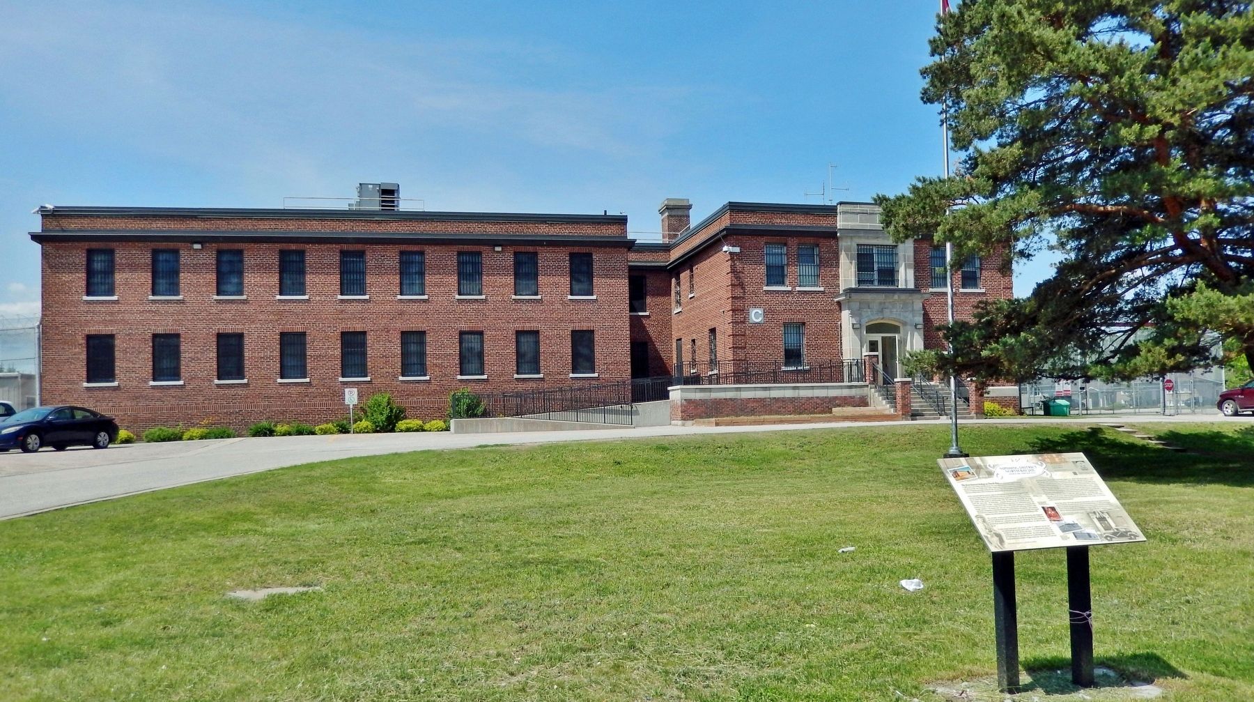
The first known lockup in North Bay was a rudimentary log structure built in 1886 at the corner of Main and Wyld Streets. Two years later the province constructed a court house and lockup on Bye, now Plouffe, Street which evolved into a . . . — — Map (db m216000) HM
On 1st Avenue West, 0.2 kilometers north of Ferguson Street, on the right when traveling north.
[English] The red brick structure on this site was the home of teacher education in North Bay from 1909 until 1972. Originally the North Bay Normal School, it was renamed North Bay Teachers' College in 1953.
In 1972 the teacher education . . . — — Map (db m195971) HM
On Main Street West at Fraser Street, on the right when traveling south on Main Street West.
John Ferguson was North Bay's first postmaster for a few weeks in 1883, operating out of his boardwood cabin. He was succeeded by William McDonald who opened a general store and post office that same year. McDonald was postmaster for 25 . . . — — Map (db m215800) HM
On Ferguson Street at McIntyre Street West, on the left when traveling east on Ferguson Street.
The construction of the Town Hall represented a defining moment in North Bay's early development. Until it was built, most municipal affairs were carried out at the Cormack block, located beside the current pedestrian laneway on Main . . . — — Map (db m215954) HM
On Main Street West at Algonquin Avenue, on the left when traveling south on Main Street West.
The Royal Theatre, under various names and owners, was one of North Bay's most important cultural and entertainment venues for close to forty years. Built in 1908 for $50,000 to a design by H. W. Angus, the Royal Theatre, also called . . . — — Map (db m215895) HM
On Main Street East, 0.1 kilometers north of Wyld Street, on the right when traveling north.
The Capitol Theatre opened on this site on June 1, 1929. The sold out opening night movie feature was a "talkie" titled, In Old Arizona. Known as "Northern Ontario's Most Beautiful Theatre," it resembled that of old Hollywood. The walls . . . — — Map (db m215799) HM
On Trans-Canada Highway (Provincial Highway 11) at O'Connor Drive, on the right when traveling north on Trans-Canada Highway.
In 1902, The Temiskaming and Northern Ontario Railway Act was given Royal Assent and construction of the railway, now operated by the Ontario Northland Transportation Commission began. By 1904 the line which was 1o link North Bay and New Liskeard . . . — — Map (db m195961) HM
On Church Street West just east of Main Street of Delhi, on the right when traveling east.
The exact starting date of the Delhi Fire Brigade (later the Delhi Fire Department), is unclear, but in 1895, an 1860s hand drawn pumper was purchased at a cost of $200, including 200 feet/61m of hose. With the firemen taking turns, they would pump . . . — — Map (db m236474) HM
On James Street (Provincial Highway 3) at Argyle Avenue, on the right when traveling north on James Street.
Two distinct groups founded the German Home and continue to be part of the Hall. They are the Saxons and Swabians (Schwaben). Although their histories are separated by time, the resolve and courage of both groups are remarkably similar. In the . . . — — Map (db m236372) HM
On Main Street of Delhi just south of Church Street West, on the right when traveling north.
[photo captions] 1. Circa 1900, west side of Main Street, Ross Eitel, the butcher, with his delivery of meat, is leading a team of horses in front of the office of "The Delhi Reporter". The cash and carry grocery store of Sam and Charlie . . . — — Map (db m236968) HM
On Main Street of Delhi at Eagle Street, on the left when traveling north on Main Street of Delhi.
[photo captions] 1. Circa 1958, looking east, many of the stores built circa early 1950s. First store from left, Taggarts Ladies Wear (previously Coni's Photography). Second from left, Mayberry S. (Stewart) Shoes. Third from left, Liquor . . . — — Map (db m237200) HM
On Main Street of Delhi at King Street (Provincial Highway 3), on the right when traveling south on Main Street of Delhi.
Frederick Sovereign is credited to the founding of the hamlet of “Sovereign’s Corners” changed later to Fredericksburg in around 1828. The railway in 1880 referred to the first station as Delhi. [photo captions] 1. Post-dated 1910, . . . — — Map (db m243592) HM
On Harbour Street, 0.1 kilometers south of St. George Street, on the right when traveling south.
The first Port Dover lighthouse was a 7.3 metre (24 foot) high wooden structure built on the west pier at the mouth of the Lynn River in 1845 as a small harbour light for the active shipbuilding, square timber trade, inshore fishery and, later, . . . — — Map (db m236339) HM
On Main Street (Highway 6) just west of Clinton Street, on the right when traveling west.
The original name of the hotel was the Royal Exchange. The back section of the hotel dates back to 1812 and the front was built between 1835 and 1840. During the Wm. Lyon Mackenzie Rebellion of 1837, the hotel served as the headquarters for . . . — — Map (db m217671) HM
On Colborne Street South at Peel Street, on the right when traveling south on Colborne Street South.
The original court-house was built on this site by 1842, and the gaol, designed by the prominent Toronto architect William Thomas, was constructed in 1848. Following a fire in 1863 which destroyed the court-house, the present structure was designed . . . — — Map (db m217592) HM
On King Street East (Provincial Highway 2) near College Street, on the right when traveling east.
This walk, sponsored by the Cobourg branch of the Architectural Conservancy of Ontario, honors Egerton Ryerson, one of the founders of Upper Canada Academy in 1832 and its second principal. The Academy, which later became Victoria College and . . . — — Map (db m90054) HM
On King Street West (Provincial Highway 2) west of 2nd Street, on the left when traveling west.
One of the finest public buildings in Canada, this imposing structure was built as an expression of civic pride and confidence in the future. It was begun in 1856 and opened by the Prince of Wales four years later. Designed by the renowned . . . — — Map (db m90084) HM
On King Street West (Provincial Highway 2) east of 3rd Street, on the right when traveling east.
This building, designed by the architect Kivas Tully in a Victorian version of the Palladian style, is representative of the finer public buildings of mid-nineteenth century Canada. One of the most impressive town halls in Ontario, it reflects the . . . — — Map (db m90086) HM
On Sussex Drive (Route 93) north of St. Patrick Street (Route 44), on the right when traveling north.
Français: Cette structure néo-gothique est l'église la plus ancienne d'Ottawa. Ses deux clochers ont été érigés en 1858. En 1848, on la nomma Cathédrale du diocèse d'Ottawa et plus tard, on lui accorda le titre de Basilique. Son . . . — — Map (db m151573) HM
Near Rideau Street (Route 34) just east of Elgin Street (Route 91), on the right when traveling west.
English:
Designed by the architectural firm of Ross and MacFarlane this hotel was built between 1908 and 1912 and enlarged in the 1920s. It was the first in a chain of Château style hotels constructed by the Grand Trunk Railway . . . — — Map (db m140226) HM
On Mackenzie Avenue (Route 93) 0.2 kilometers south of Murray Street (Route 44), on the left when traveling south.
English:
Part of a grand design for the national capital in the early 20th century, this imposing building is a tangible expression of Prime Minister Sir Wilfrid Laurier’s vision for Ottawa. The eclectic combination of Gothic and . . . — — Map (db m140195) HM
On Mackenzie Avenue (Route 93) 0.2 kilometers south of Murray Street (Route 44), on the left when traveling south.
English: In the 1890s, when Prime Minister Sir Wilfrid Laurier spoke of making Ottawa a "Washington of the North," he was building on the idea that a national capital could be consciously created. In the early 20th century, Canada's . . . — — Map (db m150692) HM
On Murray Street (Provincial Road 44) just west of Parent Avenue, on the left when traveling east.
English: Built by Ottawa Mayor Eugene Martineau, this limestone building housed four separate hotels with taverns, typical of the establishments that provided lodging to transient lumbermen in 19th century Lowertown. Fire gutted the . . . — — Map (db m149195) HM
On Sussex Drive (Route 93) just north of St. Patrick Street (Route 44), on the right when traveling north.
English:
First planned as a parish church in 1839, Notre-Dame was transformed as it achieved the status of cathedral for the new Catholic Diocese of Bytown in 1847, mother church of the Archdiocese of Ottawa, and basilica in 1879. . . . — — Map (db m140471) HM
Near Sussex Drive (Route 93) at Bruyere Street, on the left when traveling north.
English: Constructed in 1905-1908 to house a branch of the British Royal Mint, this building was one of several designed in the late gothic style by the Department of Public Works in the first part of this century. The building combines the . . . — — Map (db m137734) HM
On St. Patrick Street (Route 44) west of Parent Avenue, on the left when traveling west.
English: From 1866 until 1918 this distinguished stone building was the home and office of Dr. François-Xavier Valade, one of the physicians who examined Louis Riel to determine his sanity before his 1885 trial. The handsome . . . — — Map (db m149199) HM
Born in Stolp, Germany, Noffke immigrated to Canada at the age of five. When he was 14, he began a four-year apprenticeship with Adam Harvey, an Ottawa architect. From 1896 to 1901 he worked with Moses C. Edey, architect of Ottawa's Daly . . . — — Map (db m234795) HM
On Metcalfe Street at MacLaren Street, on the left when traveling north on Metcalfe Street.
This refined and elegant Queen Anne Revival house is as impressive now as when it was built in 1909 for lumber baron John R. Booth. Hallmark features of this style, popular from the 1880s to the 1910s, are displayed in the two main . . . — — Map (db m177977) HM
After the burning of the Parliament Buildings on the night of 3rd February, 1916, The House of Commons assembled in this building on the 4th and The Senate on the 8th February. Parliament met here for the last time on 10th November, . . . — — Map (db m217816) HM
On Wellington Street (Route 34) west of Metcalfe Street (Route 89), on the left when traveling west.
English: Designed by architect Cass Gilbert, Jr. of New York, this building was the site of the Diplomatic Mission of the United States of America from 1932 to 1999. Français: Cass Gilbert fils, architecte de New . . . — — Map (db m150892) HM
On Wellington Street (Route 34) east of Kent Street (Route 83), on the left when traveling east.
English: The Bank of Canada is the country's monetary authority. Since the Bank opened its doors in 1935, its purpose has been to promote the economic and financial well-being of Canadians. Through its monetary policy, the Bank . . . — — Map (db m150696) HM
On Wellington Street (Route 34) just east of Metcalfe Street (Route 89), on the left when traveling east.
English: This building is the nerve centre of government. The two offices housed here support Canada's prime minister in the task of governing. The Office of the Prime Minister is managed by political staff who support the prime . . . — — Map (db m150694) HM
On Wellington Street (Route 34) just west of Kent Street (Route 83), on the left when traveling west.
English: The first St. Andrew's kirk, erected here in 1828 by masons who built the Rideau Canal, was demolished in 1872. The present church, designed by W.T. Thomas, was built 1872-74. Français: La première église . . . — — Map (db m150895) HM
On Wellington Street (Route 34) just west of Kent Street (Route 83), on the left when traveling west.
English: This Gothic Revival church was designed by W.T. Thomas of Montreal, one of Canada’s most significant architects of his generation. It replaced an earlier church built when the parish was established in 1828. Designated . . . — — Map (db m150893) HM
On Wellington Street (Route 34) just west of Kent Street (Route 83), on the right when traveling west.
English: Created in 1875 by an Act of Parliament, the Supreme Court of Canada is the nation's highest court and one of its most important federal institutions. It is the final general court of appeal, the last judicial resort for . . . — — Map (db m150697) HM
On Alexandra Bridge (Saint Patrick Street), 0.4 kilometers west of Sussex Drive (Route 93), on the left when traveling west.
English: Constructed using the most advanced technologies available at the time, the Alexandra Bridge stands today as evidence of the outstanding ingenuity and foresight of Canadian engineers. G. Dunn, Chief Railway Engineer H.J. . . . — — Map (db m150888) HM
On Rideau Street, on the left when traveling east.
Rideau Street has been Ottawa's premier commercial street since the 19th Century.
These two buildings, now incorporated into the Hudson's Bay Company Store, are typical of the commercial structures that once lined the street. 89 Rideau . . . — — Map (db m199726) HM
On Armstrong Street, on the left when traveling north.
Armstrong House
Built for Judge Christopher Armstrong, this is one of the few surviving country houses of those which once existed along Richmond Road.
Maison Armstrong
Cette maison campagnarde construite pour le . . . — — Map (db m204007) HM
On Byward Market Square, on the right when traveling north.
This building is the fourth By Ward Market building designed by Richards and Abra and constructed in 1927 by the City of Ottawa. Its rectangular plan and wide ground floor canopy are well-suited to its function as a market building. — — Map (db m195920) HM
To commemorate Lieutenant-Colonel John By, R.E., builder of the Rideau Canal (1826-1832) and founder of Bytown (Later renamed Ottawa), the federal capital of the Dominion of Canada.
Erected by the Historic Landmarks Association of Canada
May 1915 . . . — — Map (db m205831) HM
During the construction of the Rideau Canal between 1826 and 1832, this structure was built as the headquarters for the Royal Engineers and Ordnance Department The three-story structure, built by the contractor Robert Drummond was completed in . . . — — Map (db m241868) HM
On Rideau Street, on the right when traveling east.
The first rail line reached Ottawa (the Bytown) in 1854, opening the region to a new wave of commerce. By century's end, the track was part of a system reaching across Canada. In the heyday of rail, 10 companies operated in the Capital Region. In . . . — — Map (db m195887) HM
WHEN Lieutenant-Colonel John By arrived from England
to oversee the
construction of the Rideau Canal, he
selected this picturesque location for his
family residence. Nestled high on a cliff,
the attractive stone house overlooked the
Ottawa . . . — — Map (db m207149) HM
Park Hill was built by Braddish Billings, a pioneer in local
lumbering and agriculture. Born in Massachusetts in 1783
he was the first settler of Gloucester Township in 1812, his
homestead forming the nucleus of Billings Bridge. In . . . — — Map (db m203056) HM
On Laurier Ave E at Chapel Street, on the left when traveling south on Laurier Ave E.
All Saints' was founded by Sir Henry Newell Bate, pre-eminent local grocer and first chairman of the Ottawa Improvement Commission (now the National Capital Commission) 1899-1917. Former prime minister Sir Robert Borden's state funeral . . . — — Map (db m178379) HM
On Dundas Street at Finkle Street, on the right when traveling east on Dundas Street.
Old Town Hall
Constructed in 1851-52 this building was for over a hundred years the centre of the municipal and social life of Woodstock. It housed the local government and also served at various times as lecture hall, opera house, . . . — — Map (db m231132) HM
On Hunter Street, 0.03 kilometers west of Graham Street, on the right when traveling west.
The first court house built on this site in 1839 served the District of Brock and later the County of Oxford. It was replaced in 1890, but this court house was not completed for 3 years. Council held their first meeting on December 6, 1892. Building . . . — — Map (db m198274) HM
On James Street at McMurray Street, on the right when traveling north on James Street.
The court house for the Territorial District of Parry Sound, established in 1870, was the first of a series of early northern court houses built under the direction of Ontario's Department of Public Works and its chief architect, Kivas Tully. . . . — — Map (db m195983) HM
On Chapel Street at Queen Street East, on the right when traveling west on Chapel Street.
This structure was originally constructed as a market and town hall in 1854. The three arches which were later closed each contained double doors opening into the market area. Three of the four windows on the front of the second storey were used to . . . — — Map (db m196179) HM
On Line 34 (Hwy 8), 2.8 kilometers east of Perth Road 107, on the right when traveling west.
Erected about 1844-5, this building was situated on the Huron Road, a pioneer highway which opened up the Canada Company's Huron Tract. Its original owner,
Sebastian Fryfogel, said to be the first settler in Perth County, was operating a . . . — — Map (db m233351) HM
On Glass Street just north of Samuel Street, on the right when traveling north.
The Grand Trunk was incorporated in 1853 to run from
Sarnia to Portland, Maine, Although it took in existing
lines, new ones had to be built, including the Toronto to
Sarnia section which was undertaken by the Canadian firm
of Gzowski and . . . — — Map (db m193016) HM
On Church Street North just north of Queen Street East (Provincial Highway 9), on the right when traveling north.
In 1904 Andrew Carnegie donated $10,000 for this limestone library. Town Council agreed to provide a site and to maintain library at $1,000 a year.
J.A. Humphris was the architect, and Robert Clyde, local stonemason, was the builder.
The . . . — — Map (db m198286) HM
On Wellington Street at Downie Street, on the left when traveling south on Wellington Street.
Opened 1899
Designers
G.W. King J.W. Siddall
Contractors Cawsey & Youngs
A floorplan of
geometric shapes
replaced earlier city
hall burnt in 1897
Refurbished 1973-74
A property designated under the
Ontario . . . — — Map (db m198310) HM
On Wellington Street at Downie Street, on the left when traveling south on Wellington Street.
[English] Stratford's spacious civic square has been the site of the city's municipal buildings since 1857. Construction began on the present city hall after the destruction of the first town hall and market by fire in 1898. The plans were . . . — — Map (db m198303) HM
Near John Street, on the right when traveling north.
This functional structure exhibits
architectural elements which evoke
a nostalgic tribute to the large, ORIGINAL
BLACKSMITH SHOP which occupied this site until
1961 was bustling hub of activity
for a sawmill, HAWKESBURY MILLS, which . . . — — Map (db m203199) HM
On Queen Street at Court Street, on the right when traveling east on Queen Street.
In 1816 the Ottawa district was established and the Courts of Quarter Session, which at that time possessed local administrative as well as judicial authority, were held in the Township of Longueuil. In 1824 Jacob Marston donated a plot of land in . . . — — Map (db m103967) HM
Maison Proulx (1885) Résidence victorienne construite par Eden Philo Johnson, époux d'Isabella Treadwell, fille de Charles Platt Treadwell, shérif et
dernier seigneur de L'Orignal. Avec ses briques rouges, sa tourelle élancée, ses
deux . . . — — Map (db m203452) HM
On Montreal Road (County Highway 2) 0.5 kilometers west of Boundary Road, on the right when traveling west.
This house, built in 1816, is a fine early example of Regency architecture and its interior is a pleasing expression of Georgian symmetry with excellent detailing. In a wooded setting and commanding an impressive view, this was a fitting home for a . . . — — Map (db m103603) HM
On Pitt Street just north of Urquhart Lane, on the right when traveling south.
English:
The Rossmore House, owned and operated by George and Martha Ross, was built in 1888 by contractor L.A. Ross, a brother to George. The four-storey brick building was reported to be the finest hotel between Montreal and . . . — — Map (db m144897) HM
On Montreal Road (Ontario Route 2), on the right when traveling west.
Once home to generations of farm families, the Stone House offers a warm, rustic, and inviting environment to visitors of our city. Built in 1850 by Martin McMartin, the 2-storey home features squared rubble masonry, three dormers and a . . . — — Map (db m218638) HM
On Fran LaFlamme Drive (Ault Park Road), on the left when traveling east.
Macleod Log House
This building was moved to Ault Park in
1974, under the supervision of the late
John Brownell, a charter member of
the Lost Villages Historical Society. He
was instrumental in locating it on the
Norman . . . — — Map (db m202454) HM
On Fran LaFlamme Drive (Ault Park Road), on the right when traveling west.
The Stuart home was donated to the Lost
Villages Historical Society in early 2004
by Cheryl (Stuart) Griffith, the niece of
the late owners Donald and Wilda Stuart,
and moved to the museum site in May of
the same year. The Griffith . . . — — Map (db m202573) HM
On Bell Street at 6th Street, on the left when traveling north on Bell Street.
After considerable negotiations for an appropriate site, school trustees settled on this location for the new building, known as The Consolidated School. It was completed in 1923 at a cost of $35,000. By 1925, the school included high school . . . — — Map (db m244520) HM
On Newton Street at Riverview Street (3rd Street), on the right when traveling north on Newton Street.
The Hudson’s Bay Company had the contract for postal service in Nipigon until 1916 when Alice Barker, a schoolteacher from Rossport, became postmistress. At that time, the post office was moved into a 315 square foot frame building on this site. . . . — — Map (db m244529) HM
On 2nd Street just west of Riverview Street, on the right when traveling west.
The Hudson’s Bay Company sold this property to the Diocese of Algoma, Church of England in 1908 for the sum of two dollars so that a house could be built for the Anglican minister. Using balloon construction with British Columbia fir and nine-foot . . . — — Map (db m244544) HM
On 2nd Street just west of Newton Street, on the right when traveling west.
In the early 1890's, a meeting was called to organize school for the local children. Businessman William McKirdy was elected the chairman of the board. By 1893, the first school in Nipigon was built on a double plot purchased for $250 from the . . . — — Map (db m244546) HM
On 1st Street just east of Newton Street, on the left when traveling east.
This house built in French Provincial style using a post and beam construction may well be the oldest residence in Nipigon. All the ceilings, walls, and floors are made with tongue-and-groove hardwood. The original insulation was birch bark and . . . — — Map (db m222201) HM
On Newton Street just north of 2nd Street, on the right when traveling north.
This log home was originally built to be a hay barn by Arvu Paju on Maatas Road about 1920. It was purchased by the Robert Fraser family, and hauled to town in 1924. Robert converted the barn into a home for his family. A blacksmith by trade, he . . . — — Map (db m244570) HM
On Front Street north of 2nd Street, on the right when traveling north.
With the arrival of the Canadian Pacific Railway in 1885, trading and commerce began to shift away from the river to the railway due to increased efficiency and cost competitiveness. By 1898, Hudson Bay Company replaced the river post with a new . . . — — Map (db m222220) HM
On 2nd Street just east of Front Street, on the right when traveling east.
Although this structure looks like a typical office building, it began its history as the Nipigon Presbyterian Church in 1899. William McKirdy built the wooden pews, and his wife Georgina played the organ, taught Sunday school and formed a Ladies . . . — — Map (db m244589) HM
On 3rd Street just east of Front Street, on the left when traveling east.
Under the modern exterior of this building is the oldest log home still standing in Nipigon. Built in 1887, it changed hands a number of times before 1925, when William and Georgina McKirdy took possession. William, the owner of the first . . . — — Map (db m244593) HM
On 1st Street east of Front Street, on the left when traveling east.
The shop where high school students buy corsages for their dates in 2002 is the very building that housed those on the wrong side of the law at the beginning of the last century. When the Township of Nipigon became incorporated in 1909, the . . . — — Map (db m222199) HM
On 5th Street just west of Railway Street, on the right when traveling west.
In 1925, Arvo Paju built the Nipigon Service Garage, the first garage in town. It was also the Imperial Esso Service Station and the General Motors Dealership. In the early 1930s, Charles and Frank Gerlach bought the business. It stayed in their . . . — — Map (db m244599) HM
On Brennan Drive, 0.2 kilometers south of 1st Street, on the right when traveling south.
The first permanent trading post in the area was established by Claude Greysolon in 1678 near the location of the present railway bridge. Some 180 years later, the Hudson's Bay Company built Red Rock Post to keep independent fur traders from . . . — — Map (db m244596) HM
On Newton Street just north of 2nd Street, on the right when traveling north.
Situated on this large corner lot with beautifully landscaped gardens, this home was originally a three-story hotel and boarding house called the Skandia House. Built in 1909 by the Olsen Brothers, the cement blocks used in the construction were . . . — — Map (db m244595) HM
On Railway Street just south of 4th Street, on the right when traveling south.
Located right on the old Trans Canada highway is the Nipigon Cafe, an outstanding example of classic art moderne and a fixture on the scene since the 1930s. Sandy and Lilly Kuorikoski, the original proprietors operated a garage at this location . . . — — Map (db m222196) HM
On Front Street just south of 5th Street, on the left when traveling south.
This property has been a resting place for travelers for more than one hundred years. The Taylor House, a large wood frame rooming house, was built on this site circa 1890. It was later known as the “Travellers and Tourists House.” Pete Prete . . . — — Map (db m244738) HM
On 2nd Street just west of Riverview Street, on the left when traveling west.
This picturesque little church dates back to 1906 when it was the first Catholic Church in Nipigon. The main body of the church seats about 70 people and a small gallery holds about 15 more. Its original location was the southwest corner of Second . . . — — Map (db m244792) HM
On Court Street North just north of Cooke Street, on the right when traveling north.
The Court Street Fire Hall, built in 1906, was designed by Port Arthur Architect, Thomas Hanley. The brick two-storey structure was designed for horse-drawn fire wagons with access provided by four round-arched wooden doors. A one-storey tower at . . . — — Map (db m227985) HM
On Donald Street East at Ross Street, on the left when traveling east on Donald Street East.
This Edwardian-style building was designed by Robert E. Mason, and constructed by Michael Braden in 1910 as a court house and police station combined. The placement of the two pilasters on the façade creates the impression that four columns exist . . . — — Map (db m227965) HM
On Arundel Street just west of Lyon Boulevard, on the right when traveling west.
Constructed in 1912 by Seaman and Penniman, this single span bridge was designed by Joachim Antonisen to harmonize with the beauty and grandeur of the landscape. Featuring arch ribs and open spandrels, its unadorned functionalism and use of . . . — — Map (db m195890) HM
Near Sleeping Giant Parkway, 0.3 kilometers north of Pearl Street, on the left when traveling north.
Joining rail and water transportation, this station, which was built in 1905 at Port Arthur and which formed the end of the line from Winnipeg, was designed in what was commonly called the Canadian Railway style by Winnipeg architect, R.B. Pratt. . . . — — Map (db m227999) HM
On Algoma Street South close to Red River Road, on the right when traveling south.
Designed by Robert J. Edwards, the school was erected in 1884. In 1901, an eight-room classroom structure, designed by C.W. Wheeler, was added. The two-storey brick structure has a symmetrical facade and the straightforward design is ornamented . . . — — Map (db m195889) HM
On May Street South just south of Donald Street, on the right when traveling south.
Thunder Bay's current city hall had two predecessors. The first (visible at right) was built in 1893. It housed Fort William's civic offices and served as a venue for community events and entertainments. It also accommodated Fort William's . . . — — Map (db m244242) HM
Near Marina Park Drive at Marina Park Overpass, on the right when traveling north.
This historic stone was embossed with the letters C.P.R. in 1907 for display under the peak of the roof of the Canadian Pacific Railway Station at Port Arthur. Commonly called Tyndall stone, it is dolomitic limestone weighing 1500 pounds and comes . . . — — Map (db m228000) HM
Near Red River Road close to Regent Street, on the right when traveling east.
Designed by Henry Simpson of Toronto with George H. Otto, general contractor, this structure was built in 1909 with classrooms being added in 1925, 1954, and a new gymnasium in 1972. The original design has medieval and Flemish architectural . . . — — Map (db m195886) HM
On Cumberland Street South at Lincoln Street, on the right when traveling south on Cumberland Street South.
The “new” Ottawa House was rebuilt on this site in 1888, after fire had destroyed two wooden hotels built earlier in the decade. A major addition was made in 1901, with the architectural detailing carefully matched. The façade features ornate . . . — — Map (db m227961) HM
On Red River Road at North Water Street, on the right when traveling west on Red River Road.
Constructed in 1909 as the Industrial Development and Publicity Bureau by the City of Port Arthur, as a special building for the purpose of furthering the industrial and general development of the city. Designed by H. Russell Halton of Fort . . . — — Map (db m243800) HM
On Brodie Street South north of Arthur Street East, on the right when traveling north.
The Thunder Bay Public Library came into being following the amalgamation of Fort William and Port Arthur in 1970. Prior to this, each city had its own library system. Both libraries emerged in the late 1800s and grew into strong community and . . . — — Map (db m195870) HM
On Red River Road at N Water Street, on the right when traveling west on Red River Road.
This tourist kiosk was erected in 1909 to promote Port Arthur's social and economic merits to visitors and investors. Its eye-catching architecture and strategic location reflect civic boosterism and the city's rivalry with nearby Fort William . . . — — Map (db m107068) HM
On Waverley Street just west of Algoma Street South, on the right when traveling east.
The city of Port Arthur’s first Methodist Church was built on this site in 1871. The present church, built in 1905 as the “Methodist Church,” was renamed “Trinity Methodist Church” in 1908. Architects were Langly-Langly from Toronto who designed . . . — — Map (db m244202) HM
On Van Norman Street at Cumberland Street North, on the right when traveling north on Van Norman Street.
Built in 1913, this magnificent eight story "skyscraper" was commissioned by James Whalen and designed by Brown and Valance of Montreal to resemble the Chicago Style and promote the City of Port Arthur as the "Chicago of the North." The exterior . . . — — Map (db m195872) HM
On Argentite Street (Commission Street) just north of Bunker Lane, on the right when traveling north.
[English] This railway station was built in 1905 and expanded in 1906 and 1908. A final expansion was started in 1909 and completed in 1910. The silver mines were a magnet for thousands of people and tons of supplies most of which . . . — — Map (db m245704) HM
On Grandview Avenue at Cobalt Street, on the right when traveling east on Grandview Avenue.
[English] Cobalt Street offers a good example of frontier style mining architecture. Most of the houses date back to the earliest days of the camp. Settling was easier in the area as people got off the train and headed past the . . . — — Map (db m245910) HM
On Main Street at Georgina Avenue, on the right when traveling west on Main Street.
[English] In 1912 the Proclamation declaring Haileybury as the District Seat gave rise to such structures as the Court House, Land Registry Office and District Jail. The proclamation was largely due to the dreams and efforts of the founder of . . . — — Map (db m195932) HM
On Government Road East (Trans-Canada Highway) (Provincial Highway 66) 0.1 kilometers east of Duncan Avenue South, on the right when traveling east.
The Public School in Kirkland Lake began with a meeting in October 1916 of local ratepayers. At that meeting the local School Board was authorized to borrow funds to erect and equip a school house. In 1924 a second school building was built to . . . — — Map (db m244797) HM
On Kirkland Street West just west of Duncan Avenue South, on the left when traveling west.
To commemorate the official opening of the Municipal Offices of the Corporation of the Town of Kirkland Lake June 26, 1980 by the Chief Administrative Officer D. B. McDougall Mayor G. L. Hamilton Councillors M. . . . — — Map (db m244796) HM
On Whitewood Avenue West at Wellington Street South, on the right when traveling east on Whitewood Avenue West.
[English] Prior to its present location, the local library had various residencies in the town. The building of the New Liskeard Library was facilitated by a grant of $10,000 from the Andrew Carnegie Library Foundation in 1910. The new . . . — — Map (db m195930) HM
On Whitewood Avenue West at Wellington Street South, on the right when traveling east on Whitewood Avenue West.
The New Liskeard Public Library Building was erected in 1910 through the assistance of a grant from Andrew Carnegie. Local limestone was used in the construction and it remains a classic example of the Carnegie libraries. Much of the original . . . — — Map (db m195929) HM
On Queen's Park Crescent East just north of Grosvenor Street, on the left when traveling north.
[English] The first university in this province, King's College was chartered in 1827 through the efforts of the Reverend John Strachan. This site was acquired by the College the following year. Sectarian and political criticism of . . . — — Map (db m207856) HM