790 entries match your criteria. The first 100 are listed. Next 100 ⊳
Canada, Ontario Heritage Trust Historical Markers
"The Provincial Plaque Program is the [Ontario Heritage] Trust’s oldest and perhaps best-known activity, with nearly 1,300 familiar blue and gold plaques in communities across Ontario..." [from the Trust's website]. This series includes the blue and gold markers previously sponsored by the Ontario Archaeological and Historic Sites Board and other name derivatives.
via Wikipedia, unknown
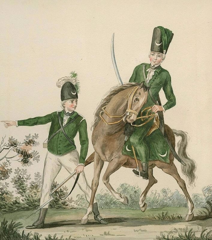
A Light Infantry Man and Huzzar of the Queen's Rangers
On Water Street at Buckner Street, on the left when traveling west on Water Street.
The Queen's Rangers, raised by Major Robert Rogers, was designated by King George III in 1779 as the lst American Regiment in recognition of its outstanding service to the Crown. The regiment along with other troops laid down arms at Yorktown on . . . — — Map (db m266243) HM
On Donnelly Drive at Burritts Avenue, on the right when traveling west on Donnelly Drive.
Begun in 1831 and completed the following year this frame
church was designed in the Gothic Revival style, customarily
used in churches of that period. The Anglican congregation had
been formed about 1822 in this part of Marlborough and . . . — — Map (db m314793) HM
On Trans-Canada Highway (Provincial Highway 17) 0.8 kilometers west of Whispering Pines Road, on the right when traveling west.
This plaque stands at approximately at the halfway point of the Trans-Canada Highway, which runs from St. John's, Newfoundland to Victoria, British Columbia. The highway's construction, in conjunction with the provinces, was authorized by the . . . — — Map (db m195918) HM
On Trans-Canada Highway (Provincial Highway 17) at Taylor Street, on the right when traveling east on Trans-Canada Highway.
The original claim to the Bruce Mine location was filed in September, 1846 by James Cuthbertson. It was acquired the following year by the Montreal Mining Company, and production commenced in 1847-48 at what became the first commercially successful . . . — — Map (db m105635) HM
On Trans-Canada Highway (Provincial Highway 17) 1.5 kilometers west of Kensington Road, on the right when traveling west.
The ripple marks on the adjacent rock face were made some two billion years ago by waves in a shallow body of water. Buried by later deposition of silt and then subjected to great pressure, the rippled sand became sandstone. The formation was . . . — — Map (db m105638) HM
On Provincial Highway 108 at Hillside Drive South, on the left when traveling north on Provincial Highway 108.
[English] Evidence of radioactive ore prompted Aimé Breton and Karl Gunterman to stake claims south of here near Lauzon Lake in Long Township in 1948. Geologist Franc R. Joubin became interested and persuaded mining . . . — — Map (db m255198) HM
On St Mary's River Drive 0.2 kilometers west of Foster Drive, on the right when traveling south.
Born in Dublin, Ireland, and raised in London, this famous 19th century author, illustrator and social reformer joined her husband, Robert Jameson, Attorney General of Upper Canada, at Toronto in 1836. The following June, unescorted, Mrs. Jameson . . . — — Map (db m105960) HM
Near Lake Street 0.6 kilometers south of Queen Street East.
Here, on a portion of his former estate, is buried Col. Prince who emigrated from England in 1833 and settled at Sandwich, Upper Canada. As commanding officer of the Essex Militia, he stirred up a violent controversy by ordering the summary . . . — — Map (db m105739) HM
On Queen Street East 0.2 kilometers west of Pim Street, on the right when traveling west.
This church was constructed in 1875 and dedicated in 1876 as the Parish Church of The Sacred Heart by Bishop Jean-Francois Jamot. It replaced a wooden building constructed in 1846 which had served as a Jesuit missionary post for this region. Built . . . — — Map (db m105953) HM
On Queen Street East 0.2 kilometers west of Riverside Drive, on the right when traveling west.
Shingwauk Hall was erected in 1935 to house a residential training school established in 1873 by the Reverend Edward F. Wilson. Under this Anglican missionary's tutelage the institution, named after the well-known Ojibway Chief Augustin Shingwauk . . . — — Map (db m105738) HM
On Canal Drive 1 kilometer west of Huron Street, on the right when traveling west.
In May, 1870, Col. Garnet Wolseley arrived here with an expeditionary force of British regulars and Canadian militia aboard the steamer "Chicora". They were travelling to Fort Garry on the Red River to put down an uprising led by Louis Riel. The . . . — — Map (db m106362) HM
Near Hub Trail 0.1 kilometers east of Canal Drive, on the right when traveling east.
Travellers on the canoe route to the West had to make a portage around the St. Mary's rapids. The North West Company established a fur-trading post south of the river by 1791. After the British abandoned their occupation of the American midwest, . . . — — Map (db m106373) HM
On Lakeside Drive just north of Stanley Street, on the right when traveling north.
Some 25 miles southwest of here lies the Detour Passage between Drummond Island and Michigan's upper peninsula. In August, 1814, it was occupied by the armed U.S. schooners "Tigress" and "Scorpion", whose intention it was to prevent supplies . . . — — Map (db m86040) HM
Near Trans-Canada Highway (National Highway 17) 1.4 kilometers south of High Falls Road, on the right when traveling south.
The nearby Michipicoten River formed an important link in the canoe route from Lake Superior to James Bay via the Michipicoten, Missinaibi and Moose Rivers. The route was probably explored at an early date by the French Fur traders who maintained a . . . — — Map (db m199496) HM
On Elm Street at William Street, on the right when traveling south on Elm Street.
Born in Paris, Ontario in 1915, Charles Joseph Sylvanus "Syl" Apps was a professional hockey player, businessman and politician. Throughout his life, Apps displayed remarkable breadth in his abilities and accomplishments. He was a varsity . . . — — Map (db m223241) HM
On Brant Highway 5 0.5 kilometers west of Sager Road, on the right when traveling west.
Ontario's thirteenth prime minister was born on this farm
and in 1913 graduated from Ontario Agricultural College.
A supporter of the United Farmers of Ontario, he was
elected to the provincial legislature in 1919 as member
for Brant North . . . — — Map (db m223085) HM
On Mount Pleasant Road 0.2 kilometers south of Ellis Avenue, on the right when traveling south.
Canadas first woman graduate in medicine was born in Mount Pleasant. She attended the Toronto School of Medicine, received her degree from Victoria University in 1883, and was licensed to practise. Her mother, Dr. Emily Howard Stowe, had graduated . . . — — Map (db m299631) HM
On Homestead Road at Hiram Road, on the right when traveling east on Homestead Road.
This house was built in 1831 by Hiram Capron, a
native of Vermont who, in 1822, had emigrated to Norfolk
County where he helped to establish one of Upper Canada's
earliest iron foundries. He settled here at the Forks of the Grand in 1829, . . . — — Map (db m223280) HM
On Paris Plains Church Road 1.1 kilometers east of Pinehurst Road, on the left when traveling east.
Built by the free labour of its own congregation with
stones gathered from nearby fields, the West Dumfries
Chapel was completed and dedicated in 1845. It is a fine
example of a type of cobblestone construction seldom
found elsewhere in . . . — — Map (db m221681) HM
On Grand River Street South at Burwell Street, on the right when traveling north on Grand River Street South.
This house and the adjoining structure were built by Asa
Wolverton, a native of Cayuga County, New York, who had
immigrated to Upper Canada in 1826. About 1832 he settled
in Paris, where he erected sawmills and became a prosperous lumber . . . — — Map (db m223265) HM
On Wellington Street just west of George Street, on the right when traveling west.
Architect John Turner and contractor William Sinon built this court house for the Provisional County of Brant in 1852-53. Turner was Brantford's most influential nineteenth-century architect, designing several important public buildings in Brant . . . — — Map (db m198273) HM
On Wellington Street just east of Market Street, on the left when traveling east. Reported missing.
In July, 1852, the Six Nations Indians sold to Brant County the land upon which this court-house now stands. Designed by John Turner and William Sinon and erected by the Provisional County of Brant, the stone and brick building was largely . . . — — Map (db m198271) HM
On Tutela Heights Road 0.8 kilometers east of Mount Pleasant Road, on the left when traveling east.
In 1877 this house, then located in downtown Brantford,
became Canada's first telephone business office. It was
the residence of the Reverend Thomas Philip Henderson
(1816-1887), a former Baptist minister and school
inspector in Paris, . . . — — Map (db m230401) HM
On Colborne Street East just east of Johnson Road, on the right when traveling east.
Across the Grand River at this point lies "Bow Park", once the farm of George Brown, a leading architect of Confederation, who built up an estate of some 800 acres beginning in 1866. A Scottish immigrant, Brown founded the Toronto "Globe" in 1844, . . . — — Map (db m284027) HM
Born into a prominent Brantford family, Lawren Harris began to paint as a child. At the University of Toronto, a professor noticed he sketched during lectures and advised he be sent to Europe to study art. While in Germany (1904-1907), . . . — — Map (db m239617) HM
On Mohawk Street close to Morrison Road, on the left when traveling west.
English: Allies of the British during the American War of Independence, the Six Nations Iroquois received extensive lands along the Grand River in 1784. Mohawks, led by Joseph Brant, established a village of some 400 individuals here by . . . — — Map (db m83697) HM
On Colborne Street East 0.3 kilometers east of Wayne Gretzky Boulevard, on the right when traveling east.
This house, "Echo Villa", was built by the Reverend Peter
Jones (Kahkewaquonaby) who lived here from 1851 until
his death. Son of the noted surveyor, Augustus Jones, and
Tuhbenahneequay, a Missisauga chief's daughter, Peter was
born at . . . — — Map (db m237708) HM
On West Street just north of Chatham Street, on the left when traveling north.
[English] An internationally renowned author, Duncan was raised in the adjacent house and educated locally. She taught school briefly, but then determinedly turned to journalism, gaining notice for her distinctive and witty writing . . . — — Map (db m215698) HM
Near Mohawk Street close to Morrison Road, on the left when traveling west.
This chapel, the first Protestant church in Ontario, was built by the Crown for the Mohawks of the Six Nations Iroquois who settled here in 1794. It replaced the Queen Anne Chapel (1712) at Fort Hunter, New York, which the Mohawk lost, . . . — — Map (db m284104) HM
On Wellington Street just east of George Street, on the left when traveling east.
In the 1820's significant improvements to the Hamilton and London road attracted settlers to the Indian lands at Brant's Ford where this thoroughfare crossed the Grand River. A thriving village soon developed and in 1830 the Six Nations surrendered . . . — — Map (db m199047) HM
On Mohawk Street, on the right when traveling west.
The Mohawk Institute
The Mohawk Institute was established in 1831 for children of the Six Nations Iroquois living on the Grand River. Pupils from other native communities in Ontario attended the school as well. Like all Canadian . . . — — Map (db m230264) HM
Near Myrtleville Drive 0.3 kilometers west of Balmoral Drive, on the right when traveling west.
[English] A leading spokesman for Canadian agrarian and co-operative movements, Good was born and raised on Myrtleville farm. He early developed a strong sense of social responsibility and, returning here after attending the . . . — — Map (db m217700) HM
On Saint Paul Avenue at Palmerston Avenue, on the right when traveling south on Saint Paul Avenue.
In 1869, on the recommendation of the Rev. Egerton Ryerson, Superintendent of Education, funds were allocated to establish the first provincial school for blind children. The Ontario Institution for the Education of the Blind, which included the . . . — — Map (db m230229) HM
On Oakland Road (County Route 4) at King Street South (County Route 24), on the right when traveling west on Oakland Road.
In October, 1814, an invading American force of about 700 men under Brigadier-General Duncan McArthur advanced rapidly up the Thames Valley. He intended to devastate the Grand River settlements and the region around the head of Lake Ontario which . . . — — Map (db m78341) HM
On 4th Line close to Chiefswood Road, on the left when traveling west.
English: An Onondaga from the Six Nations of the Grand River, Tom Longboat was one of the world's great long-distance runners. He ran his first race in Caledonia in 1905 and two years later shot to international attention with a . . . — — Map (db m83700) HM
Near County Highway 54 just east of Chiefswood Road, on the right when traveling east.
In this house "Chiefswood", erected about 1853, was born the Mohawk poetess Emily Pauline Johnson (Tekahionwake). Her father, Chief G.H.M. Johnson a greatly respected leader of the Six Nations, built "Chiefswood" as a wedding gift for her English . . . — — Map (db m208900) HM
Near Fourth Line Road at Chiefswood Road, on the left when traveling east.
English
John Brant was born in the Mohawk Village (Brantford), the youngest son of the renowned Joseph Brant. He was educated at Ancaster and Niagara, and fought with distinction during the War of 1812. Brant devoted his life to improving . . . — — Map (db m78340) HM
On Simcoe Street at Talbot Street, in the median on Simcoe Street.
Dr. Charles Duncombe (1791-1867), prominent physician and politician, was leader of the militant reform movement in the London District at the time of the Rebellion of 1837. He rallied the local "Patriots" at the settlement of Scotland, planning to . . . — — Map (db m189196) HM
On Blue Lake Road (County Road 35) 0.6 kilometers west of Brant Road (Provincial Highway 24), on the right when traveling west.
Adelaide Hunter was born in this farm house and lived here until she married John Hoodless in 1881. On February 19, 1897, she organized at Stoney Creek the world’s first Women’s Institute. It was her belief that in this organization rural women . . . — — Map (db m208855) HM
On Queen Street North (Bruce County Road 3) at Cambridge Street, on the right when traveling south on Queen Street North (Bruce County Road 3).
One of Canada's outstanding artists, Milne was born on a farm near Burgoyne, Saugeen Township, and raised in Paisley. Though largely self-taught, he studied briefly in New York at the Art Student's League, and in 1913 exhibited some of his paintings . . . — — Map (db m307595) HM
Douglas Point Nuclear Power Plant
The Douglas Point Nuclear Power Plant began generating electricity in 1967 and continued until 1984. This joint project between Atomic Energy of Canada Ltd. and Ontario Hydro was the first . . . — — Map (db m307515) HM
On Goldie Street (Provincial Highway 11) at Queen Street South, on the right when traveling west on Goldie Street.
In 1852, shortly after this region was opened for settlement, the government reserved land for a town here on the Elora and Saugeen Road, at the confluence of the Teeswater and Saugeen Rivers. Already settled on the site were Simon Orchard and . . . — — Map (db m198319) HM
On Clinton Street South at Union Street East, on the right when traveling north on Clinton Street South.
By 1855 the first permanent settlers on the site of Teeswater, the families of Matthew Hadwen and Peter Brown, had located here on the Teeswater River. In that year Brown erected a sawmill and later added a grist-mill. In 1856 a post otfice was . . . — — Map (db m278208) HM
On McNab Street 0.1 kilometers south of Durham Street East, on the right when traveling south.
In 1850 Joseph Walker came here to the Durham Road where it crosses the Saugeen River. He built an inn and contracted to build two bridges and a part of the road. He and his son William were in 1851 granted tree lots and later allowed to buy . . . — — Map (db m278239) HM
On Main Street North (Chatham-Kent County Road 22) at Elm Street East on Main Street North (Chatham-Kent County Road 22).
In 1851 George Brown, founder of the Toronto Globe and one of Canada's Fathers of Confederation, purchased about 4000 acres in this vicinity. The Great Western Railway ran through his property in 1855 and that year a station and a post office were . . . — — Map (db m272395) HM
Near William Street North at Murray Street, on the left when traveling north.
On this site a blockhouse was constructed in 1794 by order of Lieutenant-Governor John Graves Simcoe. He planned to establish here a small naval arsenal which would form a link in the defences of Upper Canada's western frontier and also draw the . . . — — Map (db m71313) HM
On King Street East just east of Prince Street South, on the left when traveling east.
On May 10, 1858, American abolitionist John Brown held the last in a series of clandestine meetings here at First Baptist Church. Brown planned to establish an independent republic within the United States and wage guerrilla war to . . . — — Map (db m71386) HM
On Stanley Avenue at 7th Street, on the left when traveling east on Stanley Avenue.
In 1847 the Kent District was established and authority was given for the erection of a court house and jail at Chatham. One year later construction began according to plans submitted by the prominent Canadian architect William Thomas. Designed in . . . — — Map (db m198312) HM
On Uncle Tom's Road at Park Street, on the right when traveling west on Uncle Tom's Road.
In the 1830s, the Reverend Josiah Henson and other abolitionists sought ways to provide refugees from slavery with the education and skills they needed to become self-sufficient in Upper Canada. They purchased 200 acres of land here in . . . — — Map (db m78376) HM
On Main Street at St. George Street, on the left when traveling east on Main Street.
In 1846 Daniel van Allen, a Chatham merchant, laid out a town plot on land purchased from Jared Lindsley, the first settler (1825) on the site of Dresden. By 1849 the erection of a steam sawmill, and the operation a grist-mill in the neighbouring . . . — — Map (db m78416) HM
On Gardiner Avenue at Lakeshore Road, on the left when traveling east on Gardiner Avenue.
On November 7, 1763 a fleet of small boats carrying nearly 700 officers and men of the 60th and 80th Regiments under Major John Wilkins was forced ashore by a violent storm abut three miles east of this point. The expedition had set out from Niagara . . . — — Map (db m108505) HM
On Longwoods Road (County Route 2), on the right when traveling east.
In September 1813, during the second year of the War of 1812, the United States won control of Lake Erie, cutting British supply lines with the east and forcing the British to withdraw from the Detroit River region. Then, on October 5, . . . — — Map (db m78367) HM
On Dufferin Avenue 0.1 kilometers east of McNaughton Avenue, on the right when traveling east.
One of the foremost 19th century arms inventors, Lee was born in Scotland. In 1836 his family came to Canada and settled at Galt. Lee was trained in his father's profession of watchmaker and jeweller, before moving to Wisconsin about 1858, where he . . . — — Map (db m272462) HM
On James Street at Fork Street, on the right when traveling east on James Street.
The Chippewa surrendered their lands in this area by treaty in 1796. The first European presence in the area was Lord Selkirk's nearby Baldoon Settlement, founded in 1804. It failed because of its poor location, but some of the settlers . . . — — Map (db m272407) HM
On Saint Clair Parkway at Langstaff Line, on the left when traveling north on Saint Clair Parkway.
On September 5, 1804 fifteen families of Scottish
emigrants numbering some ninety persons landed near this site. Named after an estate in Scotland, the settlement was sponsored by Lord Selkirk who later founded the Red River Colony. The low-lying . . . — — Map (db m272487) HM
On Trans-Canada Highway (Provincial Highway 11) at Beadman Road (Zucks Road), on the right when traveling west on Trans-Canada Highway.
The surveying of the line which intersects Highway No. 11 here (survey mile post 162) was the first step taken by the Ontario government in the exploration and development of this region. During the 1890s, interest in Ontario's northern mineral, . . . — — Map (db m217895) HM
On Railway Street 0.1 kilometers east of 7th Avenue South, on the right when traveling east.
[English] For centuries the site of Cochrane was used by indigenous peoples as a summer camping ground. Later it became a stopping place for fur traders en route to Moose Factory. In 1907 the Temiskaming and Northern Ontario Railway . . . — — Map (db m217898) HM
On Frederick House Lake Road 1.6 kilometers east of Connaught Road, on the right when traveling east.
[English] A Hudson's Bay Company post named after a son of George III, Frederick House was established in 1785 to prevent Canadian fur traders in the Abitibi region from intercepting the passage of furs to Moose Fort (Moose Factory) . . . — — Map (db m217973) HM
On Cambridge Avenue at Synagogue Avenue, on the left when traveling north on Cambridge Avenue.
[English] This region's first inhabitants were aboriginal peoples who were attracted by its abundant natural resources and extensive water routes. Europeans arrived in the late 1600s to acquire furs and establish trade with the . . . — — Map (db m217890) HM
On Trans-Canada Highway (Provincial Highway 11) 1 kilometer south of Provincial Highway 67, on the left when traveling south.
Born in Latchford and raised near Porquis Junction, Cosens enlisted in the Argyle and Sutherland Regiment, Canadian Active Service Force, in 1940 and transferred to the Queen's Own Rifles of Canada in 1944. Early on February 26, 1945, his unit . . . — — Map (db m217896) HM
Near Fourth Avenue (Provincial Highway 101) just north of 2nd Street, on the left when traveling north.
On July 29, 1916, fires which had been burning for some weeks around settlers' clearings along the Timiskaming & Northern Ontario Railway were united by strong winds into one huge conflagration. Burning easterly along a 40-mile front, it largely or . . . — — Map (db m217800) HM
On King Street (Provincial Highway 101) at Bellemare Street, on the right when traveling west on King Street.
[English] From the 1880s onwards, as railways opened up northern Ontario, prospecting activity in this region intensified. The Porcupine gold rush began in 1909 following three significant discoveries. Thousands of prospectors and . . . — — Map (db m217899) HM
Near Bloor Avenue 0.2 kilometers east of Crawford Street.
[English] In the summer of 1911, when the Porcupine gold rush was at its height, the weather was hot and dry. On July 11, gale-force winds from the southwest whipped individual bush fires into a 16-km sea of flames that swiftly . . . — — Map (db m217900) HM
On Riverside Drive (Algonquin Boulevard West) (Provincial Highway 101) 0.2 kilometers east of Craig Street, on the left when traveling east.
[English] The first French-language radio station in Ontario, CFCL-Timmins, began broadcasting in December 1951. The event was greeted with enthusiasm by Franco-Ontarians who until then had heard limited programming in French over . . . — — Map (db m217793) HM
On Trans-Canada Highway (Provincial Highway 11) at Hanna Road, on the right when traveling north on Trans-Canada Highway.
At this point the 49th parallel of latitude north of the equator crosses the highway. This line forms the southern boundary of the western provinces of Manitoba, Saskatchewan, Alberta and most of British Columbia. In 1818 a treaty between Great . . . — — Map (db m217889) HM
On Mill Street 0.1 kilometers east of Main Street, on the right when traveling east.
In 1830 Lewis Horning, a successful settler from the Hamilton
area, located in this vicinity with his family. He cleared
80 acres of land and built a sawmill, grist-mill and frame
house, but later returned to Hamilton. With the opening of
a . . . — — Map (db m305824) HM
On Zina Street at Louisa Street, on the right when traveling west on Zina Street.
Construction of this imposing brick court house was begun in the spring of 1880. Designed by C.J. Soule, a Guelph architect, it was built by the contracting firm of Dobbie and Grierson. Although the first provisional county council meeting was held . . . — — Map (db m196159) HM
On Victoria Street at Main Street East, on the right when traveling north on Victoria Street.
Settlement of Melancthon Township began in the late 1840's and coincided with the construction of the Toronto-Sydenham Road. By the 1860's settlers had moved into the Shelburne area and in 1865 William Jelly, one of the community's earliest . . . — — Map (db m305686) HM
On Harwood Avenue South, on the right when traveling north.
The Founding of Ajax
In 1941, the Government of Canada established a shell-filling plant operated by Defence Industries Limited on this site. During its peak of production, over 9,000 people from across the country lived and worked . . . — — Map (db m258928) HM
On Old Kingston Road just west of Church Street North, on the left when traveling west.
Between 1801 and 1807 a settlement developed here in Pickering Township where the Danforth Road crossed Duffin's Creek. Among the early settlers was Timothy Rogers, a prominent Quaker and colonizer who built a saw and grist-mill in 1809. A . . . — — Map (db m208413) HM
Near Peace Street just north of McRae Street, on the right when traveling north.
Robert Holmes spent a lifetime drawing and painting Canadian wildflowers, depicting many varieties in water-colours. Holmes was born in Cannington and is buried here. After studying at the Ontario School of Art and the Royal College of Art, his . . . — — Map (db m147898) HM
On King Avenue East 0.1 kilometers Beaver Street North, on the left when traveling east.
One of Canada's leading publishers, Joseph Atkinson was born here in Clarke Township and, at eighteen, began his journalistic career with the Port Hope Times. He subsequently moved to Toronto where he was employed first with the World and later the . . . — — Map (db m244766) HM
On Temperance Street at King Street West, on the right when traveling south on Temperance Street.
An ardent Canadian and founder of the Canadian Club movement, McCullough was born in Bowmanville and moved to Hamilton in 1888. He and four companions in December, 1892, determined to found an organization which would encourage the study of Canada's . . . — — Map (db m245082) HM
On Courtice Road at Bloor Street, on the right when traveling north on Courtice Road.
Perhaps the most fervent of the Methodist sects, the Bible Christian Church was formed in southwestern England in 1815 and established in Upper Canada during the 1830s.
Served by itinerant preachers, its small but loyal memberShip . . . — — Map (db m245216) HM
On Old Kirby School Road at Ganaraska Road, on the left when traveling north on Old Kirby School Road.
A distinguished authority on tropical diseases, Stanton was born near here and educated at Trinity Medical College, Toronto. In 1907, after serving as house surgeon at the Hospital for Tropical Diseases in London, England, he accepted a . . . — — Map (db m244768) HM
On Mill Street South at Edward Street West, on the right when traveling south on Mill Street South.
An outstanding humanitarian and churchman, Brent was born near Newcastle and ordained in Toronto in 1887. Following parochial service in Buffalo and Boston, he was elected first Episcopal Bishop of the Philippine Islands in 1901. Confronted by the . . . — — Map (db m284029) HM
On Durham Regional Highway 2 0.2 kilometers east of Cobbledick Road, on the right when traveling west.
On this site in 1866 Samuel Wilmot began to experiment with the artificial breeding of salmon. His success led the federal government in 1868 to enlarge Wilmot’s project into Ontario's first full scale fish hatchery, one of the earliest in North . . . — — Map (db m244767) HM
On King Avenue East at Beaver Street South on King Avenue East.
The Masseys at Newcastle
One of the world's largest manufacturers of heavy farm machinery, Massey-Ferguson has its foundations in a modest family business developed in Newcastle. Established in Bond Head by Daniel Massey, the . . . — — Map (db m244762) HM
On Concession Road 7 0.5 kilometers west of Liberty Street North, on the right when traveling west.
Robert McLaughlin, a pioneer of the Canadian vehicle industry, was born in the family homestead on this property. In 1867, despite lack of technical training, he built two cutters in his driving-shed which stood near this site. His business . . . — — Map (db m244813) HM
On Durham Regional Road 1 just north of Leaskdale Road, on the right when traveling north.
In this house the author of “Anne of Green Gables” lived for fifteen years, and here wrote eleven of her twenty-two novels, including “Anne of the Island” (1915) and “Anne’s House of Dreams” (1916). Born in 1874 at Clifton, Prince Edward Island, . . . — — Map (db m199500) HM
Near Simcoe Street North (Durham Regional Road 2) just south of Parkwood Court, on the right when traveling south.
Born in nearby Enniskillen, McLaughlin apprenticed in his father's Oshawa carriage works when he was sixteen. Convinced of the potential for growth of the automobile industry, he established in 1907 the McLaughlin Motor Car Company, the first major . . . — — Map (db m198928) HM
On Simcoe Street South 0.2 kilometers south of Lakeview Park Avenue, on the right when traveling south.
Ontario’s twelfth prime minister was born in Oshawa and educated at the University at Toronto and Osgoode Hall. A practising lawyer, he was a leader in civic affairs and in 1916-17 served as mayor of Oshawa. During the tollowing years he had various . . . — — Map (db m245225) HM
On Portview Road just east of Island Road (Durham Regional Road 7), on the right when traveling east.
One of Canada's leading cartoonists, Jimmy Frise was born near here about 1891 and educated at Scugog, Saintfield and Port Perry. Wounded at Vimy Ridge in the First World War, he went to Toronto to resume his career in illustrations, a field in . . . — — Map (db m254051) HM
On Reynolds Street at Gilbert Street East, on the left when traveling south on Reynolds Street.
Opened in 1874 by the Governor-General, Lord Dufferin, the Ontario Ladies’ College was established in "Trafalgar Castle", former residence of Nelson Gilbert Reynolds, Sheriff of Ontario County. Built in 1859, "Trafalgar Castle" was visited im 1869 . . . — — Map (db m245264) HM
On Talbot Street West at Centre Street, on the left when traveling west on Talbot Street West.
In October, 1817, John Van Patter, an emigrant from New York State, obtained 200 acres of land and became the first settler on the site of Aylmer. During the 1830's a general store was opened and village lots sold. Originally called Tray, in 1835 it . . . — — Map (db m255222) HM
On Erieus Street near Pitt Street, on the right when traveling south.
Born of Loyalist parents, Burwell became a deputy-surveyor in 1809 and was instructed to lay out the Talbot road for settlement. He was granted 600 acres of land in Southwold Township where he settled in 1815. A close associate of Col. Thomas . . . — — Map (db m252695) HM
On Robinson Street just south of Pitt Street, on the right when traveling south.
The Port Burwell lighthouse was constructed in 1840. It was part of a national network of light stations equipped with beacon lights to warn or guide ships at sea. The Port Burwell light was used to aid navigation and commercial shipping of local . . . — — Map (db m198238) HM
On Pitt Street at Strachan Street, on the left when traveling east on Pitt Street.
This frame building was begun in 1836 and completed the following year. An example of simple early Gothic Revival architecture, this church was constructed as a result of the interest and substantial financial assistance of Lieutenant-Colonel Mahlon . . . — — Map (db m252721) HM
On Colborne Street at Matilda Street, on the left when traveling south on Colborne Street.
Born in Massachusetts, Bostwick came as a child to Norfolk County. He was appointed high constable of the London District in 1800 and sheriff in 1805. A deputy surveyor, he laid out some of the earliest roads in the Talbot Settlement and in 1804 was . . . — — Map (db m284031) HM
On Bridge Street, on the right when traveling west.
The London and Port Stanley Railroad
After the Great Western Railway reached London in 1853, local businessmen and politicians began promoting a competitive line south to Lake Erie. The London and Port Stanley Railway began . . . — — Map (db m253034) HM
On Ron McNeil Line (County Road 52) at Whittaker Road (County Road 49), on the left when traveling west on Ron McNeil Line (County Road 52).
About 1850, some ten years after this area was settled, a school and a Methodist meeting house were erected here on the town line between the Townships of South Dorchester and Malahide.
Shortly afterwards a post-office named Clunas was opened, with . . . — — Map (db m255220) HM
On Talbot Street at Mondamin Street on Talbot Street.
Emigrating from New York State to the Long Point Settlement in 1802, Rapelje later received 200 acres of land on the south side of the Talbot Road at Kettle Creek. He settled here with his family in 1810. A veteran of Lundy's Lane and other battles . . . — — Map (db m255828) HM
On Wellington Street at Queen Street, on the right when traveling east on Wellington Street.
Founder of the Talbot Settlement, he was born at Castle Malahide, Ireland, a member of the Anglo-Irish nobility. In 1803, after serving in the British Army, and on Simcoe's staff, he was granted 5,000 acres in this region and settled in Dunwich . . . — — Map (db m255637) HM
On Pleasant Street at Talbot Street, on the right when traveling south on Pleasant Street.
This house was built in 1848 by Dr. Elijah Duncombe brother of Dr. Charles Duncombe. The latter, born in Connecticut, came to Upper Canada in 1819 and settled on this property shortly thereafter.
In 1824, with Dr. John Rolph, he opened at St. . . . — — Map (db m255573) HM
On Talbot Street at Mary Street, on the right when traveling east on Talbot Street.
Ontario's eleventh prime minister was born in nearby Yarmouth Township and educated at St. Thomas Collegiate. After serving in World War I, he was elected to the federal parliament in 1926 as member for Elgin West. In 1930 he was named leader of the . . . — — Map (db m255738) HM
On Sunset Drive (County Road 4) 0.4 kilometers north of John Wise Line, on the right when traveling north.
RCAF Technical Training School
The only facility of its kind in Ontario during the Second World War, No. 1 Technical Training School, St. Thomas, was established by the Royal Canadian Air Force in 1939 to produce skilled ground crews for . . . — — Map (db m255293) HM
Near Talbot Street east of Horton Street, on the right when traveling east.
[English] The St. Thomas Canada Southern (CASO) Station, financed by American railway promoters, was constructed between 1871 and 1873 to serve as both the passenger station for St. Thomas and CASO's corporate headquarters. During the 1920s, . . . — — Map (db m198268) HM
On Walnut Street at Church Street, on the right when traveling east on Walnut Street.
This church was completed in 1824 on land given by Capt.
Daniel Rapelje, the founder of the city of St. Thomas.
It is one of the province's finest remaining examples
of Early English Gothic Revival architecture. In 1825
a tower, steeple and . . . — — Map (db m255608) HM
On Fingal Line 1.6 kilometers west of Sunset Drive, on the right when traveling east.
This property once belonged to John Rolph, a prominent
physician, lawyer and legislator. Born in England, he
emigrated to Upper Canada in 1812. In 1824, with Dr.
Charles Duncombe, he established at St. Thomas the
province's first medical school, . . . — — Map (db m255560) HM
On Sparta Line 1.2 kilometers west of Quaker Road, on the right when traveling west.
Jonathan Doan (1765-1847), a member of the Society of Friends, came to Upper Canada from Pennsylvania about 1789. He settled first in the Niagara peninsula, and then purchased 200 acres of wilderness here in south Yarmouth Township in . . . — — Map (db m252787) HM
790 entries matched your criteria. The first 100 are listed above. Next 100 ⊳