294 entries match your criteria. Entries 101 through 200 are listed.⊲ Previous 100 — The final 94 ⊳
Historical Markers and War Memorials in New Brunswick
By Cosmos Mariner, July 29, 2019
MacNarin Family History Panel
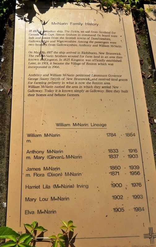
| 101 ► New Brunswick, Kent County, Rexton — MacNarin Family History — The MacNarin Sisters — MacNarin Park — |
| On Rue Main (New Brunswick Route 134) just north of Bonner Law Avenue (New Brunswick Route 116), on the left when traveling north. | |||
| 102 ► New Brunswick, Kent County, Rexton — Old Kingston Hall — |
| On Rue Main (New Brunswick Route 134) just north of Cail Court, on the right when traveling north. | |||
| 103 ► New Brunswick, Kent County, Rexton — Saint John's the Evangelist Anglican Church — |
| On Queen Street just north of Rue Main (New Brunswick Route 134), on the right when traveling north. | |||
| 104 ► New Brunswick, Kent County, Rexton — The Bridges / Les Ponts — |
| On Rue Main (New Brunswick Route 134) north of River Street, on the right when traveling north. | |||
| 105 ► New Brunswick, Kent County, Rexton — The Historic Village of Rexton — |
| Near North Street, 0.3 kilometers east of Rue Main (New Brunswick Route 134), on the right when traveling east. | |||
| 106 ► New Brunswick, Kent County, Rexton — The Honourable Shawn Michael Graham — (2006-2010) — |
| Near Rue Main (New Brunswick Route 134) north of Queen Street, on the right when traveling north. | |||
| 107 ► New Brunswick, Kent County, Rexton — The Masts / Les Mâts — |
| Near North Street, 0.3 kilometers east of Rue Main (New Brunswick Route 134), on the right when traveling east. | |||
| 108 ► New Brunswick, Kent County, Rexton — Village Historique de Rexton / Rexton Historic Village — |
| On Rue Main (New Brunswick Route 134) just north of Cail Court, on the right when traveling north. | |||
| 109 ► New Brunswick, Kent County, Rexton — Wooden Ships and Iron Men / Navires en Bois et Hommes de Fer — |
| Near North Street, 0.3 kilometers east of Rue Main (New Brunswick Route 134), on the right when traveling east. | |||
| 110 ► New Brunswick, Kent County, Saint-Antoine — Louis J. Robichaud — 1925-2005 — |
| Near Rue Principale (Route 115) south of Rue Edouard, on the left when traveling south. | |||
| 111 ► New Brunswick, Kent County, Saint-Louis-de-Kent — Marcel-François Richard — (1847-1915) — |
| On Rue Principale (Main Street) (New Brunswick Route 134) at Chemin Desherbiers (Desherbiers Road), on the right when traveling south on Rue Principale (Main Street). | |||
| 112 ► New Brunswick, Kings County, Sussex — Dominion Building — 1883 — Sussex Preservation Area Heritage Property — |
| On Main Street (New Brunswick Route 121) at Broad Street/Maple Avenue, on the right when traveling west on Main Street. | |||
| 113 ► New Brunswick, Kings County, Sussex — Leonard's Gate — |
| On Main Street (New Brunswick Route 121) east of Peter Street, on the left when traveling east. | |||
| 114 ► New Brunswick, Kings County, Sussex — Site of One of the First Irving Service Stations — |
| On Queen Street at Main Street (New Brunswick Route 121), on the left when traveling south on Queen Street. | |||
| 115 ► New Brunswick, Kings County, Sussex — War Memorial — |
| On Broad Street just east of Queen Street, on the left when traveling east. | |||
| 116 ► New Brunswick, Kings County, Sussex — War Memorial — |
| On Broad Street just east of Queen Street, on the left when traveling east. | |||
| 117 ► New Brunswick, Madawaska County, Edmundston — Archibald Fraser — (1869-1932) — |
| On Rue Victoria south of Station Street, on the right when traveling south. | |||
| 118 ► New Brunswick, Madawaska County, Saint Leonard — Clarence Bourgoin — |
| On Rue Saint Jean (New Brunswick Route 17) 0.2 kilometers north of Rue Principale (New Brunswick Route 144), on the left when traveling north. | |||
| 119 ► New Brunswick, Northumberland County, Blackville — Legend of the Dungarvon Whooper — |
| Near Main Street (New Brunswick Route 8) 0.3 kilometers north of Campbell Road (New Brunswick Route 118), on the right when traveling north. | |||
| 120 ► New Brunswick, Northumberland County, Blackville — Millstones — |
| Near Main Street (New Brunswick Route 8) 0.3 kilometers north of Campbell Road (New Brunswick Route 118), on the right when traveling north. | |||
| 121 ► New Brunswick, Northumberland County, Miramichi — Lord Beaverbrook — |
| Near Loggie Drive just north of Cunard Street, on the left when traveling north. | |||
| 122 ► New Brunswick, Restigouche County, Kedgwick — M114 155mm Howitzer — |
| On rue Notre Dame (New Brunswick Route 17) just west of rue Saint Jean, on the right when traveling west. | |||
| 123 ► New Brunswick, Restigouche County, Kedgwick — Veterans Memorial — Kedgwick, N.B. — |
| On rue Notre Dame (New Brunswick Route 17) just west of rue Saint Jean, on the right when traveling west. | |||
| 124 ► New Brunswick, Restigouche County, Saint-Quentin — La croix et le coq du clocher / The Steeple Cross and Rooster Vane — Haltes à travers le temps / Steps in History — |
| On rue Canada (New Brunswick Route 17) just south of rue Deschênes, on the left when traveling south. | |||
| 125 ► New Brunswick, Restigouche County, Saint-Quentin — Le monument aux fondateurs / The Founders Monument — Haltes à travers le temps / Steps in History — |
| On rue Canada (New Brunswick Route 17) just south of rue Deschênes, on the left when traveling south. | |||
| 126 ► New Brunswick, Restigouche County, Saint-Quentin — Saint-Quentin Hommage militaire / Military Tribute — 1918 - 2008 — « La Madone » / "The Madonna" — |
| On rue Deschênes just east of rue Canada (New Brunswick Route 17), on the left when traveling east. | |||
| 127 ► New Brunswick, Restigouche County, Saint-Quentin — Veterans Memorial — |
| On rue Deschênes just east of rue Canada (New Brunswick Route 17), on the left when traveling east. | |||
| 128 ► New Brunswick, Saint John County, Saint John — 1 Chipman Hill — |
| On Chipman Hill just south of Union Street, on the left when traveling north. | |||
| 129 ► New Brunswick, Saint John County, Saint John — A Legacy of Tea | Du thé en héritage — People Waiting Making Art Public | Rendre l’art public — Harbour Passage Trail — |
| On Market Square just east of Water Street, on the right when traveling east. | |||
| 130 ► New Brunswick, Saint John County, Saint John — A Portal to the New World — La porte du Nouveau Monde — Harbour Passage Trail — |
| On Water Street just west of Prince William Street, on the left when traveling south. | |||
| 131 ► New Brunswick, Saint John County, Saint John — An Island Abounding With Life — Une île pleine de vie — Harbour Passage Trail — |
| On Prince William Street at Saint James Street, on the left when traveling north on Prince William Street. | |||
| 132 ► New Brunswick, Saint John County, Saint John — Ancient Life — D’anciennes formes de vie — |
| Near Chesley Drive (New Brunswick Route 100) at Bentley Street, on the right when traveling north. | |||
| 133 ► New Brunswick, Saint John County, Saint John — Benedict Arnold — Rebel and Loyalist | Rebelle et loyaliste — |
| Near Lancaster Avenue, 0.2 kilometers east of Bridge Road (New Brunswick Route 100), on the left when traveling east. | |||
| 134 ► New Brunswick, Saint John County, Saint John — Canada’s Original City — La ville originale du Canada — |
| Near North Market Wharf close to Smythe Street. | |||
| 135 ► New Brunswick, Saint John County, Saint John — Carleton Martello Tower — Tour Martello Carleton — |
| Near Whipple Street near Lancaster Street. | |||
| 136 ► New Brunswick, Saint John County, Saint John — Centerbeam Place — |
| On Prince William Street at King Street, on the left when traveling south on Prince William Street. | |||
| 137 ► New Brunswick, Saint John County, Saint John — Charles Gorman — |
| Near Lancaster Avenue, 0.2 kilometers east of Bridge Road (New Brunswick Route 100), on the left when traveling east. | |||
| 138 ► New Brunswick, Saint John County, Saint John — Church of Saint Andrew and Saint David — Église Saint Andrew and Saint David — |
| On Germain Street close to Duke Street, on the left when traveling south. | |||
| 139 ► New Brunswick, Saint John County, Saint John — Clearing Customs in Style — Franchir les douanes avec grâce — Harbour Passage Trail — |
| On Water Street at Duke Street, on the right when traveling south on Water Street. | |||
| 140 ► New Brunswick, Saint John County, Saint John — Colonel Gabriel G. Ludlow — First Mayor of Saint John | Premier maire de Saint John — |
| Near Lancaster Avenue, 0.2 kilometers east of Bridge Road (New Brunswick Route 100), on the left when traveling east. | |||
| 141 ► New Brunswick, Saint John County, Saint John — Defending the Harbour — À la défense du port — Harbour Passage Trail — |
| On Union Street just west of Smythe Street when traveling west. | |||
| 142 ► New Brunswick, Saint John County, Saint John — Dock Street Generating Station — Le Centrale Dock Street — 1889-1976 — |
| Near Smythe Street. | |||
| 143 ► New Brunswick, Saint John County, Saint John — Electrifying the Uptown — L’électrification du centre-ville — Harbour Passage Trail — |
| Near Union Street just west of Smythe Street, on the right when traveling west. | |||
| 144 ► New Brunswick, Saint John County, Saint John — First Marine Compound Engine — La Première Machine Compound de Marine — |
| On Peters Wharf at Water Street, on the right when traveling east on Peters Wharf. | |||
| 145 ► New Brunswick, Saint John County, Saint John — First Steam Fog Horn — La Premiere Corne de Brume a Vapeur — |
| On Peters Wharf at Water Street, on the right when traveling east on Peters Wharf. | |||
| 146 ► New Brunswick, Saint John County, Saint John — Fishing the Harbour — La pêche dans le port — Harbour Passage Trail — |
| Near Chesley Drive (New Brunswick Route 100) at Bentley Street, on the right when traveling north. | |||
| 147 ► New Brunswick, Saint John County, Saint John — Fort Howe — Major Gilfrid Studholme — Indian Treaty of 1778/Le Traité Indien de 1778 — |
| On Magazine Street close to Metcalf Street. | |||
| 148 ► New Brunswick, Saint John County, Saint John — Fort La Tour — |
| Near Fort Latour Drive at Navy Way when traveling east. | |||
| 149 ► New Brunswick, Saint John County, Saint John — Fort La Tour — Le Fort La Tour — |
| Near Fort Latour Drive at Navy Way, on the right when traveling east. | |||
| 150 ► New Brunswick, Saint John County, Saint John — Fort La Tour — |
| Near Fort Latour Drive at Navy Way, on the right when traveling east. | |||
| 151 ► New Brunswick, Saint John County, Saint John — Fossil Hunters — Chasseurs de fossiles — |
| Near Chesley Drive (New Brunswick Route 100) at Bentley Street, on the right when traveling north. | |||
| 152 ► New Brunswick, Saint John County, Saint John — Founding of New Brunswick — La Fondation du Nouveau-Brunswick — |
| On Sydney Street close to Kings Square North, on the left when traveling north. | |||
| 153 ► New Brunswick, Saint John County, Saint John — Françoise Marie Jacquelin — and the Battle for Fort La Tour / et la lutte pour le fort La Tour — |
| Near Lancaster Avenue, 0.2 kilometers east of Bridge Road (New Brunswick Route 100), on the left when traveling east. | |||
| 154 ► New Brunswick, Saint John County, Saint John — George B. Oland — Moosehead Breweries / La Brasserie Moosehead — |
| Near Lancaster Avenue, 0.2 kilometers east of Bridge Road (New Brunswick Route 100), on the left when traveling east. | |||
| 155 ► New Brunswick, Saint John County, Saint John — Here Stood the House Occupied by Benedict Arnold — |
| On Canterbury Street just south of King Street, on the right when traveling south. | |||
| 156 ► New Brunswick, Saint John County, Saint John — Imperial Theatre — Le Théâtre Imperial — |
| On Kings Square South close to Sydney Street, on the right when traveling west. | |||
| 157 ► New Brunswick, Saint John County, Saint John — Irish Immigrant Memorial — |
| On Water Street, 0.03 kilometers north of Prince William Street, on the left when traveling south. | |||
| 158 ► New Brunswick, Saint John County, Saint John — John Robertson — Lord of the North / Le Lord du Nord — |
| Near Lancaster Avenue, 0.2 kilometers east of Bridge Road (New Brunswick Route 100), on the left when traveling east. | |||
| 159 ► New Brunswick, Saint John County, Saint John — K.C. Irving — |
| Near Lancaster Avenue, 0.2 kilometers Bridge Road (New Brunswick Route 100), on the left when traveling east. | |||
| 160 ► New Brunswick, Saint John County, Saint John — King Edward VII Memorial Bandstand — Kiosque À Musique Commémoratif Roi Edouard VII — |
| On Charlotte Street close to King Street, on the left when traveling south. | |||
| 161 ► New Brunswick, Saint John County, Saint John — King’s Square — Carré King’s Square — Established 1785/Fondé en 1785 — |
| On Charlotte Street close to King Street, on the left when traveling south. | |||
| 162 ► New Brunswick, Saint John County, Saint John — Koluskap and Beaver — Koluskap et le castor — |
| Near Lancaster Avenue, 0.2 kilometers Bridge Road (New Brunswick Route 100), on the left when traveling east. | |||
| 163 ► New Brunswick, Saint John County, Saint John — Land of the Dawn — La terre de l’aurore — |
| Near Lancaster Avenue, 0.2 kilometers east of Bridge Road (New Brunswick Route 100), on the left when traveling east. | |||
| 164 ► New Brunswick, Saint John County, Saint John — Loyalist House — La Maison Loyaliste — |
| On Union Street just west of Germain Street (Wellington Row), on the right when traveling east. | |||
| 165 ► New Brunswick, Saint John County, Saint John — Menahkwesk "Saint John" — |
| Near Fort Latour Drive at Navy Way when traveling east. | |||
| 166 ► New Brunswick, Saint John County, Saint John — Mills at Union Point — Les usines à Union Point — |
| Near Lancaster Avenue, 0.2 kilometers east of Bridge Road (Route 100), on the left when traveling east. | |||
| 167 ► New Brunswick, Saint John County, Saint John — Navy Island (Ouigoudy Island) — Harbour Passage Trail — |
| Near Chesley Drive (New Brunswick Route 100) at Bentley Street, on the right when traveling north. | |||
| 168 ► New Brunswick, Saint John County, Saint John — New Brunswick’s First School of Law — |
| On Canterbury Street close to Princess Street, on the left when traveling north. | |||
| 169 ► New Brunswick, Saint John County, Saint John — No. 2 Mechanics’ Volunteer Company Engine House — Caserne No 2 des Mécaniciens Pompiers Volontaires — |
| On Sydney Street close to Kings Square South, on the right when traveling west. | |||
| 170 ► New Brunswick, Saint John County, Saint John — Oland Family Breweries — |
| Near Market Square (North Market Wharf) just west of St. Patrick Street, on the right when traveling west. | |||
| 171 ► New Brunswick, Saint John County, Saint John — Partridge Island — L’île Partridge — |
| Near Smythe Street at North Market Wharf, on the right when traveling south. | |||
| 172 ► New Brunswick, Saint John County, Saint John — Prince William Street - Before and After the 1877 Fire — Rue Prince William - Avant et Après le Grand Incendie de 1877 — |
| On Prince William Street near King Street, on the left when traveling south. | |||
| 173 ► New Brunswick, Saint John County, Saint John — Prince William Streetscape — La Rue Prince William — |
| On Prince William Street at Princess Street, on the left when traveling north on Prince William Street. | |||
| 174 ► New Brunswick, Saint John County, Saint John — Rebels Attack — Les attaques des rebelles — |
| Near Lancaster Avenue, 0.2 kilometers east of Bridge Road (New Brunswick Route 100), on the left when traveling east. | |||
| 175 ► New Brunswick, Saint John County, Saint John — Robert Foulis — |
| Near Lancaster Avenue, 0.2 kilometers east of Bridge Road (New Brunswick Route 100), on the left when traveling east. | |||
| 176 ► New Brunswick, Saint John County, Saint John — Saint John – The Working Port — Saint John, port en activité — Harbour Passage Trail — |
| On Long Wharf, 0.1 kilometers west of Smythe Street, on the left when traveling west. | |||
| 177 ► New Brunswick, Saint John County, Saint John — Saint John 225th Anniversary Clock — |
| On King Street just east of Prince William Street, on the right when traveling east. | |||
| 178 ► New Brunswick, Saint John County, Saint John — Saint John City Market — Le Marché de Saint John — |
| On Charlotte Street at Market Street on Charlotte Street. | |||
| 179 ► New Brunswick, Saint John County, Saint John — Saint John Harbour Defensive Network — Réseau défensif du port de Saint John — Provincial Historic Site | Lieu historique provincial — |
| On Union Street, 0.03 kilometers west of Smythe Street when traveling west. | |||
| 180 ► New Brunswick, Saint John County, Saint John — Saint John’s First Wind Grist Mill — |
| On Kings Square South, on the right when traveling east. | |||
| 181 ► New Brunswick, Saint John County, Saint John — Saint John’s Original Burial Ground — Le premier cimetière de Saint John — |
| Near Sydney Street close to Kings Street East. | |||
| 182 ► New Brunswick, Saint John County, Saint John — Samuel de Champlain — Names St. John River on June 24, 1604 / Il nomme le fleuve Saint-Jean le 24 juin 1604 — |
| Near Lancaster Avenue, 0.2 kilometers east of Bridge Road (New Brunswick Route 100), on the left when traveling east. | |||
| 183 ► New Brunswick, Saint John County, Saint John — Scottish Strength — La puissance écossaise — |
| On Market Square at Water Street, on the right when traveling east on Market Square. | |||
| 184 ► New Brunswick, Saint John County, Saint John — Shedding Light on the Three Sisters Mystery — Faire la lumière sur le mystère des trois sœurs — Harbour Passage Trail — |
| On Prince William Street at Saint James Street, on the left when traveling north on Prince William Street. | |||
| 185 ► New Brunswick, Saint John County, Saint John — Simonds, Hazen and White — A Partnership / Un partenariat — |
| Near Lancaster Avenue, 0.2 kilometers east of Bridge Road (New Brunswick Route 100), on the left when traveling east. | |||
| 186 ► New Brunswick, Saint John County, Saint John — Sir Samuel Leonard Tilley — Father of Confederation / Père de la Confédération — |
| Near Lancaster Avenue, 0.2 kilometers east of Bridge Road (New Brunswick Route 100), on the left when traveling east. | |||
| 187 ► New Brunswick, Saint John County, Saint John — St. John’s (stone) Church — L’Église St. John — |
| On Carleton Street at Wellington Row, on the right when traveling west on Carleton Street. | |||
| 188 ► New Brunswick, Saint John County, Saint John — The "Three Lamps" — |
| On Prince William Street at Saint James Street, on the left when traveling north on Prince William Street. | |||
| 189 ► New Brunswick, Saint John County, Saint John — The Marco Polo — Le Marco Polo — |
| On Market Square near Chipman Hill, on the left when traveling east. | |||
| 190 ► New Brunswick, Saint John County, Saint John — The Great Fire of 1877 | L’incendie de 1877 — Trinity Royal — Saint John’s First Historic Preservation Area Premiere de conservation historique de Saint John — |
| On King Street at Germain Street, on the right when traveling east on King Street. | |||
| 191 ► New Brunswick, Saint John County, Saint John — The Landing of the Loyalists — Débarquement des Loyalistes — |
| Near Market Square at Water Street, on the right when traveling east. | |||
| 192 ► New Brunswick, Saint John County, Saint John — The Largest in British North America — La plus grande en Amérique du Nord britannique — Harbour Passage Trail — |
| On Water Street north of Prince William Street, on the left when traveling north. | |||
| 193 ► New Brunswick, Saint John County, Saint John — The Marco Polo / Le Marco Polo — The Fastest Ship in the World / Le navire le plus rapide du monde — |
| On Water Street north of Prince William Street, on the left when traveling south. | |||
| 194 ► New Brunswick, Saint John County, Saint John — The New Community of Saint John — La nouvelle localité de Saint John — |
| Near Lancaster Avenue, 0.2 kilometers east of Bridge Road (New Brunswick Route 100), on the left when traveling east. | |||
| 195 ► New Brunswick, Saint John County, Saint John — The Saint John Harbour Bridge | Le pont du port de Saint John — Connecting the City | Un accès à la ville — Harbour Passage Trail — |
| Near Navy Way, 0.1 kilometers east of Chesley Drive (New Brunswick Route 100), on the right when traveling east. | |||
| 196 ► New Brunswick, Saint John County, Saint John — The Shards of Time — by Peter Powning — |
| Near Fort Latour Drive, 0.2 kilometers east of Chesley Drive (New Brunswick Route 100), on the right when traveling east. | |||
| 197 ► New Brunswick, Saint John County, Saint John — The Tides of Fundy — Les Marées de Fundy — Harbour Passage Trail — |
| Near Navy Way, 0.1 kilometers east of Chesley Drive (New Brunswick Route 100), on the right when traveling east. | |||
| 198 ► New Brunswick, Saint John County, Saint John — The Troop Fleet in the Days of Sail — |
| On Prince William Street close to Duke Street. | |||
| 199 ► New Brunswick, Saint John County, Saint John — Thomas Stockwell Simms — T.S. Simms & Co., Brush Makers to the World / fabricant de brosses pour le monde entier — |
| Near Lancaster Avenue, 0.2 kilometers east of Bridge Road (New Brunswick Route 100), on the left when traveling east. | |||
| 200 ► New Brunswick, Saint John County, Saint John — Touch Two Ancient Continents — Toucher à deux anciens continents — Harbour Passage Trail — |
| Near Chesley Drive (New Brunswick Route 100) at Douglas Avenue, on the right when traveling north. | |||
294 entries matched your criteria. Entries 101 through 200 are listed above. ⊲ Previous 100 — The final 94 ⊳