On Homestead Road at Hiram Road, on the right when traveling east on Homestead Road.
This house was built in 1831 by Hiram Capron, a
native of Vermont who, in 1822, had emigrated to Norfolk
County where he helped to establish one of Upper Canada's
earliest iron foundries. He settled here at the Forks of the Grand in 1829, . . . — — Map (db m223280) HM
On Grand River Street South at Burwell Street, on the right when traveling north on Grand River Street South.
This house and the adjoining structure were built by Asa
Wolverton, a native of Cayuga County, New York, who had
immigrated to Upper Canada in 1826. About 1832 he settled
in Paris, where he erected sawmills and became a prosperous lumber . . . — — Map (db m223265) HM
On Wellington Street just west of George Street, on the right when traveling west.
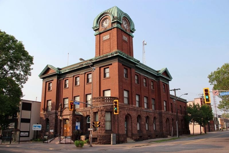
Architect John Turner and contractor William Sinon built this court house for the Provisional County of Brant in 1852-53. Turner was Brantford's most influential nineteenth-century architect, designing several important public buildings in Brant . . . — — Map (db m198273) HM
On Wellington Street just east of Market Street, on the left when traveling east. Reported missing.
In July, 1852, the Six Nations Indians sold to Brant County the land upon which this court-house now stands. Designed by John Turner and William Sinon and erected by the Provisional County of Brant, the stone and brick building was largely . . . — — Map (db m198271) HM
On George Street just north of Darling Street, on the right when traveling north.
Designed by John Turner and built in 1883, Park Baptist Church served as a place of worship for over a century until a dwindling membership led to closure in 1992. The fate of the building remained uncertain until 2000 at which time restoration . . . — — Map (db m215890) HM
On Dalhousie Street just west of George Street, on the right when traveling west.
Royal Victoria Place, originally known as the Commercial Buildings, was designed by John Turner and built in 1881 by Bernhard Heyd. One of the first occupants was the Royal Loan and Savings Company. Following a devastating fire in 1988, . . . — — Map (db m215851) HM
On Mohawk Street, on the right when traveling west.
The Mohawk Institute
The Mohawk Institute was established in 1831 for children of the Six Nations Iroquois living on the Grand River. Pupils from other native communities in Ontario attended the school as well. Like all Canadian . . . — — Map (db m230264) HM
Near Darling Street just west of George Street, on the right when traveling west.
Victoria Park was set aside as a square when Lewis Burwell surveyed the original town plan for Brantford in 1830. The square was first landscaped as a formal park in 1861. The plans were prepared by John Turner, a local architect who designed many . . . — — Map (db m215847) HM
Near County Highway 54 just east of Chiefswood Road, on the right when traveling east.
[English] Completed in 1856, Chiefswood owes its importance to its architecture and the prominence of the people who lived here. Derived from the popular Italianate style of the Picturesque movement, the grandeur of the house . . . — — Map (db m209067) HM
On Main Street South (County Road 13) at High Street, on the right when traveling north on Main Street South.
This building was presented in memory of Salem Griswold Kitchen by his wife was remodeled by the citizens of the community and is a memorial to the soldiers who fought in the Great War These made the supreme sacrifice Armstrong Walter N . . . — — Map (db m243442) HM WM
On Stanley Avenue at 7th Street, on the left when traveling east on Stanley Avenue.
In 1847 the Kent District was established and authority was given for the erection of a court house and jail at Chatham. One year later construction began according to plans submitted by the prominent Canadian architect William Thomas. Designed in . . . — — Map (db m198312) HM
On Cambridge Avenue just south of Fyfe Street, on the right when traveling south.
Was and continues to be recognized country wide. It was clear from the onset this town was to reflect strong and fresh designs complete withGarden Town Themes Our town is claimed as being the first planned community in Canada. Research . . . — — Map (db m245498) HM
On Anson Drive at Essex Avenue, on the right when traveling west on Anson Drive.
A new IFPS officially opened on January 16, 1941. At the time Mr. J. L. Harkness (1941-1958) was the principal. In 1977 a new gymnasium was constructed with Mr. Alan Taylor (1958-1985) as principal. In 2006 the school was demolished and . . . — — Map (db m245458) HM
On Bloor Avenue at Main Street, on the right when traveling west on Bloor Avenue.
Official opening: January 16, 1939 Reeve: Victor H. Evans Council: George Helmer, Melvin Cavanagh, Emil Heino, William Fairhurst Last council at amalgamation: December 31, 1972 Reeve: Ernie R. White Council: Dennis Pope, Maurice Londry, Luigi . . . — — Map (db m244988) HM
On Zina Street at Louisa Street, on the right when traveling west on Zina Street.
Construction of this imposing brick court house was begun in the spring of 1880. Designed by C.J. Soule, a Guelph architect, it was built by the contracting firm of Dobbie and Grierson. Although the first provisional county council meeting was held . . . — — Map (db m196159) HM
On Randall Drive at Kingston Road West (Durham Regional Highway 2), on the left when traveling north on Randall Drive.
The parish of St. George’s Anglican Church was founded at Duffins Creek (now known as Pickering Village) in 1832. The first incumbent of the parish, the Reverend Adam Elliot, originally met with his parishioners at their homes in an area that . . . — — Map (db m243739) HM
On Temperance Street at Church Street, on the right when traveling south on Temperance Street.
This structure is the third to be used as a town hall in Bowmanville's history. The
first was on the site of Central Public School (NW corner of Elgin and Wellington). It was a large wooden building that also served as a court house and school. . . . — — Map (db m245078) HM
On Church Street, 0.1 kilometers west of Temperance Street, on the right when traveling west.
This once prestigious property, the 'Rathskamory Estate' was the residence of Dr. George Lowe. With its well groomed gardens surrounded by stately beech, maple & elm trees, this beautiful ten acre property lay between Lowe & Concession Streets. Also . . . — — Map (db m245208) HM
On Temperance Street at Church Street, on the right when traveling north on Temperance Street.
Both St. Andrew & St. Paul's Churches derive their roots from the same early Presbyterian congregation which began holding formal services in 1843. The first St. Andrew's Church, a small frame building, was opened here in 1842 on a parcel of land . . . — — Map (db m245123) HM
On Durham Regional Road 1 (Concession Road 7) just north of Leaskdale Road, on the right when traveling north.
[English] From 1911 to 1926, this Presbyterian manse was home to Lucy Maud Montgomery, the world-famous author whose writing career was launched in Prince Edward Island. Here at Leaskdale she began her role as a wife and mother, and . . . — — Map (db m199578) HM
Near Simcoe Street North (Durham Regional Road 2) just south of Parkwood Court, on the right when traveling south.
[English] A rare surviving example of the grand estates of the inter-war years, Parkwood consists of a richly decorated house set in 12 acres of grounds. The house, originally constructed in 1916-1917 to the designs of the Toronto . . . — — Map (db m208899) HM
Near Simcoe Street North (Durham Regional Road 2) just south of Parkwood Court, on the right when traveling south.
Born in nearby Enniskillen, McLaughlin apprenticed in his father's Oshawa carriage works when he was sixteen. Convinced of the potential for growth of the automobile industry, he established in 1907 the McLaughlin Motor Car Company, the first major . . . — — Map (db m198928) HM
On Athol Street East just east of Celina Street, on the left when traveling east.
The Borsberry Music Hall was located on the north side of King Street, just east of Simcoe Street, a century ago. The Music Hall had a 700 seat capacity and played host to a number of dramatic and musical productions. The street scene outside the . . . — — Map (db m227851) HM
Near Metcalfe Street just west of Simcoe Street South (Provincial Highway 2), on the left when traveling west.
[left panel]This building was made possible by the generous gift of Col. R. S. McLaughlin for the appreciation of music by the people of Oshawa ——— Dedicated in the year of our Lord 1942[right panel]And . . . — — Map (db m227899) HM
On Simcoe Street South, 0.2 kilometers Lakeview Park Avenue, on the right when traveling south.
"A very busy and thriving neighbourhood the harbour must have been in the middle decades of the last century when the Lake was the principal highway, when a great part of what was brought in came to the wharf, as well as most of what was sent . . . — — Map (db m245234) HM
Near Simcoe Street South, 0.2 kilometers south of Lakeview Park Avenue, on the right when traveling south.
"The house looked much the same as it does now. The buffalo house was behind Henry House and was used for a storage shed after the buffalo were taken away. "
- Betty MacInally
The land where Henry House stands was purchased by the Henry . . . — — Map (db m245223) HM
On Simcoe Street South, 0.2 kilometers Lakeview Park Avenue.
"It was more of a mystery to the kids of the area. For some reason on the main level of the house there was a pile of leather cuttings.
The kids used to dare one another to get pieces of leather to prove their entry into the house. You were . . . — — Map (db m245228) HM
On Dundas Street West at Byron Street North, on the right when traveling west on Dundas Street West.
James Rutledge, chairman of the Board of Education, laid the corner stone for this building on June 9, 1913. The library was funded by the Carnegie Corporation in the United States, and was officially opened by the County Clerk John E. Farewell on . . . — — Map (db m217981) HM
On Reynolds Street at Gilbert Street East, on the left when traveling south on Reynolds Street.
Opened in 1874 by the Governor-General, Lord Dufferin, the Ontario Ladies’ College was established in "Trafalgar Castle", former residence of Nelson Gilbert Reynolds, Sheriff of Ontario County. Built in 1859, "Trafalgar Castle" was visited im 1869 . . . — — Map (db m245264) HM
On Byron Street North just south of Mary Street West, on the right when traveling south.
The Terrace, built as a fashionable address for professionals and their offices, is probably one of the finest examples of small-town Ontario row housing still standing in the province. The Whitby Local Architectural Conservation Advisory . . . — — Map (db m218147) HM
Near Talbot Street east of Horton Street, on the right when traveling east.
[English] The St. Thomas Canada Southern (CASO) Station, financed by American railway promoters, was constructed between 1871 and 1873 to serve as both the passenger station for St. Thomas and CASO's corporate headquarters. During the 1920s, . . . — — Map (db m198268) HM
On Dalhousie Street, on the left when traveling south.
This house, one of the finest remaining examples of domestic Georgian architecture in Ontario, was commenced in 1816 and completed about 1819, by Robert Reynolds, the commissary to the garrison at Fort Malden. Bellevue was also the home of his . . . — — Map (db m103677) HM
On Sandwich Street West just north of Brock Street, on the right when traveling north.
When the British withdrew from Detroit in 1796, they transferred the courts of the Western District to Sandwich (Windsor). An abandoned blockhouse, relocated from Chatham, served briefly as the court house and gaol until fire destroyed it in 1797. . . . — — Map (db m198382) HM
On King Street East north of West Street, on the right when traveling north.
This limestone double house was erected in the Georgian style by architect William Coverdale in 1842-43 for Noble Palmer, founder of the Kingston Spectator newspaper. It is notable for its windows and ashlar string courses.
Half of the building . . . — — Map (db m144999) HM
On Munsee Street North, 0.2 kilometers north of Echo Street West, on the right when traveling south.
Judicial Complex, Haldimand County
Court House, 1923, Jail 1850-51,
Registry Office 1871, Jailer's Residence 1877
Built as part of the original judicial complex, the
stone jail was designed by Cumberland and Ridout.
The registry office . . . — — Map (db m235119) HM
On Munsee Road North, 0.1 kilometers north of Echo Street West, on the right when traveling south.
Haldimand County
Heritage Landmark
circa 1835
Nicholas
Log Cabin
A fine example of one of the
few remaining early pioneer
hand hewn timber constructed
log cabins in Haldimand County.
It was built by Thomas Nicholas
beside the Old . . . — — Map (db m235457) HM
This country estate is a fine example of 19th-century Picturesque landscape design. Developed in the 1840s by David Thompson, promoter of the Grand River Navigation Company, its buildings and grounds are carefully integrated to create . . . — — Map (db m230560) HM
On Front Street North (Haldimand Highway 54), 0.1 kilometers south of King Avenue, on the right when traveling north.
Also known as Mansion House
Georgian design with Regency
influence Purchased in 1923
from Lemuel Lowery by Masters
and Wardens of Enniskillen Lodge
AF & AM No. 185 — — Map (db m234919) HM
On Lakeshore Road at North Shore Boulevard East, on the right when traveling south on Lakeshore Road.
The original house on this site was built about 1800 by the famous Mohawk chief Joseph Brant (Thayendanegea). Two years previously Captain Brant had been granted some 3500 acres of land in this area for his military services to the Crown during . . . — — Map (db m233215) HM
On North Shore Boulevard West, 0.1 kilometers east of La Salle Park Road, on the right when traveling east.
Built in 1917 by The City of Hamilton on the former Wabasso Park Lands acquired in 1913, as a combination dance and picnic Pavilion. Its form of open verandah set between two arcaded pavilions decorated with pilasters, is characteristic of the Art . . . — — Map (db m243825) HM
On Navy Street at William Street, on the right when traveling south on Navy Street.
William Chisholm’s first priorities for Oakville’s economic development were developing the harbour, building a grist and sawmill, and setting up a shipyard.
This activity, along with the declaration of the harbour as a Port of Entry for . . . — — Map (db m238303) HM
On Trafalgar Road at Sumner Avenue, on the right when traveling north on Trafalgar Road.
As Oakville’s population and
prosperity increased, stately homes were built near George's Square. These houses represent different architectural styles and designs from various periods in the town's development.
19th Century Heritage Homes . . . — — Map (db m238721) HM
On Navy Street at William Street, on the right when traveling south on Navy Street.
The early settlers of Oakville, while full of optimism lacked formal training- there were few master builders or architects at the time. In fact, the shipbuilders who came to work for Chisholm in the shipyard also built many of the first houses . . . — — Map (db m238338) HM
On Navy Street at William Street, on the right when traveling south on Navy Street.
Period Homes
For the greater part of the nineteenth century, the centre hall Georgian plan remained popular. In the early homes, this basic form was embellished with door and window surrounds and cornice treatments. The degree of decorative . . . — — Map (db m238341) HM
On Navy Street at William Street, on the right when traveling south on Navy Street.
An Act to incorporate the Town of Oakville was assented to on May 27th, 1857. The first council members were:
Mayor G.K. Chisholm Farmer & Landowner
Ward 1 R.K. Chisholm Customs Agent & Postmaster
W.E. Hagaman General Merchant
Ward . . . — — Map (db m238339) HM
Sovereign House (circa 1825)
Officially opened September 23, 1995
by Her Worship Mayor Ann Mulvale
The Sovereign House was the residence of Charles Sovereign; a founding father of Bronte Village. From 1911-1914, the home became the . . . — — Map (db m243012) HM
On Stuart Street, 0.1 kilometers east of Bay Street North, on the right when traveling east.
[English] The former Customs House (1858-1860) is a fine example of the Italianate style of architecture which was popular in Canada from the 1840s through the 1870s. Inspired by Renaissance palazzi of Rome and Florence, Italianate buildings . . . — — Map (db m196259) HM
The Hermitage Estate encompassed a mansion, several
outbuildings, and a large farm. Throughout the mid-nineteenth century, the farm thrived under George Leith's management, producing hay, oats, barley, and wheat crops. He also grew carrots, . . . — — Map (db m226401) HM
The Hermitage had several owners before it was acquired by George Gordon Browne Leith (1812 -1887) in 1855. Mr. Leith, a wealthy Irish-born Scottish immigrant, settled his family on the land because of its proximity to the privileges of the . . . — — Map (db m226349) HM
On James Street North, 0.3 kilometers north of Cannon Street East, on the right when traveling north.
CHRIST'S CHURCH CATHEDRAL
An important ecclesiastical centre for the Niagara Peninsula, Christ's Church was erected in stages, its form altered as the size and prominence of the congregation increased. Begun in 1835 as a parish church, . . . — — Map (db m218769) HM
On James Street North at Murray Street East, on the right when traveling north on James Street North.
[English] This building recalls the importance of the railway to the development of Canada's industrial cities. Completed in 1931, it combines a strong classical design with a fluid circulation plan, making it one of the best urban stations . . . — — Map (db m196260) HM
On James Street North, 0.1 kilometers north of Cannon Street East, on the right when traveling north.
JOHN WEIR FOOTE ARMOURY
The north section of this building
(1887-1888) is a rare surviving example
of the second wave of armoury
construction in Canada. Designed
by Henry James, it exemplifies the
replacement of earlier wooden . . . — — Map (db m218780) HM
On James Street North, 0.1 kilometers north of Cannon East, on the right when traveling north.
The Lieutenant-Colonel
John Weir Foote, VC, CD Armoury
This armoury is dedicated to the memory of
Lieutenant-Colonel john Weir Foote. VC. CD.
padre of the Royal Hamilton Light Infantry.
padre Foote was awarded the Victoria . . . — — Map (db m222052) HM
On Bay Street North at Barton Street West, on the left when traveling north on Bay Street North.
The Harmony building, created in 1935, was the dream of Dr. Vincenzo Agro. He emigrated from Italy and was troubled by the Fascist movement in this city. He believed some local Italians showed more love for the old land than the new. Agro led the . . . — — Map (db m230427) HM
On Sheaffe Street at Park Street North, on the right when traveling east on Sheaffe Street.
ST. MARY'S PRO-CATHEDRAL
One of the few Roman Catholic churches in Ontario retaining its pre-Confederation character, St. Mary's was erected in 1859-60 during the episcopate of Bishop John Farrell to replace a building destroyed by . . . — — Map (db m218828) HM
On Main Street East at Ottawa Street North, on the left when traveling east on Main Street East.
As hostilities ceased in late 1918, Hamilton's leaders began to consider how to best honour the men of Hamilton who had given their lives in the Great War. The Hamilton
Board of Education was the first group to finalize such a plan. They . . . — — Map (db m226270) HM
On Charlton Ave. West at Caroline Street South, on the left when traveling west on Charlton Ave. West.
CENTRAL PRESBYTERIAN CHURCH
Erected to serve a thriving congregation established in
1841, Central Presbyterian Church was built in 1907-08
after an earlier building was destroyed by fire. It is
reputedly the only church designed by . . . — — Map (db m218565) HM
On Hunter Street West at Bay Street South, on the left when traveling west on Hunter Street West.
This school, built to accommodate 1,000 students, was the largest graded school in Upper Canada, and became the only public school in Hamilton, at the time of its opening in 1853. Among the earliest examples of an institution inspired by the . . . — — Map (db m220407) HM
On MacNab Street South at Hurst Place, on the right when traveling north on MacNab Street South.
The MacNab-Charles Heritage Conservation District is one of the finest concentrations of pre-Confederation architecture in Hamilton. It evokes a Hamilton in its founding stages, when Scottish Presbyterian settlers erected new churches and houses . . . — — Map (db m234787) HM
On Duke Street at MacNab Street South, on the left when traveling west on Duke Street.
Built about 1856, at a time of rapid growth in Hamilton, Sandyford Place is a fine example of the housing then being erected for the merchants of the period. It is a rare survivor in Canada of the few row
houses built for affluent . . . — — Map (db m218512) HM
On James Street South at Jackson Street West, on the right when traveling south on James Street South.
Begun in 1854 and completed three years later, this Presbyterian church was designed in the Gothic Revival style by architect William Thomas. The elegant eighty-foot spire set atop a hundred-foot tower marks the building as an outstanding example . . . — — Map (db m221813) HM
On James Street South at Jackson Street West, on the right when traveling south on James Street South.
Erected in 1854-1857, St. Paul's (formerly St. Andrew's) is an elegant example of the Gothic Revival style. The design of the church shows the influence of the Ecclesiological Movement which favoured plans based on English medieval . . . — — Map (db m218245) HM
Near Jackson Street West, 0.1 kilometers west of Jackson W. and MacNab S., on the left when traveling west.
Set in a rare walled garden and enriched by its interior decoration, Whitehern is a remarkably intact example of mid-19th century residential architecture. The lingering influence of the Palladian style combined with Neoclassical motifs . . . — — Map (db m218635) HM
On Jackson Street West at MacNab Street South, on the left when traveling west on Jackson Street West.
This stately mansion is a finely crafted and well preserved
example of Hamilton's early stone architecture. Built no
later than 1850 for city clerk and attorney Richard Duggan, it was purchased in 1852 by Calvin McQuesten, M. D. (1801-85), a . . . — — Map (db m221805) HM
On Beach Boulevard, on the right when traveling north.
Victorian summer homes
In the 1870s, prominent, wealthy Hamiltonians began building summer
homes on the Beach Strip. Three surviving examples, all built in the early 1890s, are described here. These homes were distinguished by their wood . . . — — Map (db m241489) HM
On Woodward Avenue, 0.3 kilometers south of Nikola Tesla Boulevard, on the right when traveling north.
The Hamilton Waterworks
This dignified building, reminiscent of the style of a Roman aqueduct, houses one of Canada's greatest surviving engineering achievements of the mid-19th century, the Hamilton Waterworks. Built between 1857 . . . — — Map (db m227140) HM
On Clairmont Access at Inverness Avenue west, on the right when traveling south on Clairmont Access.
By 1850, a four storey building called the Mountain View Hotel was erected on this site. Its proximity to the escarpment's edge provided an unobstructed view of the city, harbour and lake. Two hundred pine steps at the base of the escarpment . . . — — Map (db m226084) HM
On Fennell Avenue West at West 5th Street, on the right when traveling west on Fennell Avenue West.
The Honourable Isaac Buchanan and Auchmar
Isaac Buchanan was born in 1810 in Glasgow into a family that owned the Auchmar estate on the shores of Loch Lomond. At the age of 19 he was sent to Montreal to open a branch of an importing firm. . . . — — Map (db m225887) HM
On Locke Street North, 0.2 kilometers north of King Street West, on the left when traveling north.
Quick Facts: Site of 1860, 1864, 1872 Provincial Expositions - Queen Victoria's Jubilee
Built in 1860 to host the Provincial Exposition, the Crystal Palace was constructed on a 22 acre site as a modern facility capable of hosting the fair. The . . . — — Map (db m228564) HM
On Locke Street North at Morden Street, on the left when traveling north on Locke Street North.
Erskine Presbyterian Church
Quick Facts: Opened in 1874 - Renamed Erskine 1880
- Memorial Hall dedicated 1923
In 1874 the Pearl Street Presbyterian Mission opened on Pearl Street, north of Florence Street. It was renamed Erskine by its first . . . — — Map (db m229295) HM
On Strathcona Avenue North at Head Street, on the right when traveling north on Strathcona Avenue North.
Quick Facts: Construction completed 1897 • In use January 2, 1902 - August 31, 1959
In the 1880s Hamilton's West End community was growing rapidly.
The closest fire protection was a volunteer station on the northeast
corner of the Crystal . . . — — Map (db m229483) HM
On Concession Street, 0.1 kilometers east of East 43rd Street, on the left when traveling east.
John William Kerr emigrated from Ireland to Canada in the 1840s and settled a crown grant on the Hamilton Mountain in the 1850s. Kerr was made the first provincial fisheries overseer by royal warrant in 1864. From a telescope on the escarpment . . . — — Map (db m223692) HM
On Dundas Street East (Hamilton Regional Road 5), 0.1 kilometers east of Main Street North, on the right when traveling west.
In 1919 a "Community League" was organized with the goal of constructing a building to function as both a memorial to citizens who had enlisted in World War I (1914-1918) and as a community hall.
The Waterdown Women's Institute purchased this . . . — — Map (db m243593) HM
On West Street at Waterloo Street South, on the left when traveling west on West Street.
Goderich
Founded 1827 • Dedicated • Incorporated 1850
May 1, 2010
The Goderich Dominion Post Office and Customs Office was built in 1889-1890. The imposing grey stone Romanesque Revival building was designed by Thomas Fuller, Chief . . . — — Map (db m192987) HM
On Van Horne Avenue just north of King Street, on the right when traveling north.
Built in 1897 by J. S. McFadyenMr. McFadyen built several of the town’s early buildings including the first jail & council chamber in 1904. — — Map (db m243242) HM
On King Street just east of Earl Avenue, on the left when traveling east.
This building was built in 1911 by postmistress, Mrs. Ida Smith. With Ida's death in 1921, her daughter Aldra became owner and postmistress. In 1926, Mr. John Harris became owner and postmaster. The post office was moved in 1939. Mr. & Mrs. . . . — — Map (db m243297) HM
On 35 Centre Street, on the right when traveling north.
Built about 1840, Bellevue House is one of the most interesting examples surviving in Canada of "Italian Villa" architecture, a style that was new in the country and novel in Kingston. This type of residence subsequently became popular . . . — — Map (db m207210) HM
On Court Street east of Barrie Street, on the left when traveling east.
English:
This grand Neo-classical building has served the courts of Frontenac County since its opening in 1858. Designed by the Dorset-born architect, Edward Horsey, it is superbly sited on land originally acquired in 1840 for a . . . — — Map (db m140193) HM
On King Street East at Clarence Street, on the left when traveling north on King Street East.
English:
Designed by the Montréal architectural firm of Hopkins, Lawford and Nelson, the Kingston Custom House was built in 1856-59 for the government of the united Canadas. The symmetrical composition of the two-storey ashlar . . . — — Map (db m140194) HM
On Clarence Street just east of Wellington Street, on the right when traveling east.
English:
In 1856-59 the government of the united Canadas erected the Kingston Post Office. Designed by the Montreal architectural firm of Hopkins, Lawford and Nelson, this limestone building shows the influence of the British . . . — — Map (db m140197) HM
Near Centre St, on the right when traveling north.
The coach house was a large two-
storey structure built of rough-cut
stone. It was used for stabling horses,
and housed the carriages and sleighs.
In addition, it contained a root cellar.
In the twentieth century, the . . . — — Map (db m207604) HM
On Mill Street at Little Bridge Street, on the right when traveling west on Mill Street.
Begun in 1889 and finished in 1891, this building was erected to house postal and customs services. Federal chief architect Thomas Fuller was responsible for the design and Robert Cameron was the contractor. The building was part of a national . . . — — Map (db m104019) HM
On Provincial Highway 2, 3.6 kilometers west of Blue Church Road, on the right when traveling west. Reported missing.
Construction of Homewood was begun in 1800 by Dr. Solomon Jones, a prominent Loyalist, local officeholder and early resident of this region. With its balanced five-bay façade, centre hallway plan and classical detailing, it reflects the influence of . . . — — Map (db m205243) HM
On Centre Street at Dibble Street West, on the left when traveling north on Centre Street.
Harry Horwood came to Canada from England in the early 1850s and started working as a stained glass maker in Toronto. In 1881 he established his own stained glass business in Prescott, first on Water Street and later in the old municipal . . . — — Map (db m242712) HM
On James Street West at Centre Street, on the right when traveling east on James Street West.
The Grenville County Historical Society Inc. recognizes the contributions of the congregation
of the Anglican Parish of St. John the Evangelist, Prescott on their 175th anniversary in the year 1996.
The Anglican Parish of St. John the . . . — — Map (db m242719) HM
On Queens Avenue at Richmond Street, on the right when traveling west on Queens Avenue.
[English] The Dominion Public Building was built in 1935-36 by what is now known as Public Works and Government Services Canada in the Classical Moderne style using stylized Art Deco decorative carvings in the masonry. The local architects . . . — — Map (db m198247) HM
On Dundas Street, on the right when traveling east.
Completed in 1905, the London Armouries is attributed to Department of Public Works architect, T. E. Fuller. It was the home of the militia units of the Royal Canadian Regiment, the First Hussars, the Royal Canadian Artillery, Royal Canadian Army . . . — — Map (db m18929) HM
On Main Street West at Murray Street, on the right when traveling west on Main Street West.
A Loyalist from the Mohawk Valley, New York, Nelles came
to Canada during the American Revolution and from 1780 to
1784 served in the Indian Department. Following hostilities he settled near the Grand River but by 1792 had moved to this area. . . . — — Map (db m233660) HM
On Main Street at Church Lane, on the right when traveling north on Main Street.
This Regency-style cottage was built circa 1840. The original building was almost square in plan, and the interior wooden flooring suggests that it had a small front living room, two bedrooms and a kitchen/work area. The exterior featured a hipped . . . — — Map (db m245557) HM
On Queen Street, 0.08 kilometers east of Regent Street, on the right when traveling east.
[English] This is the third and only surviving court house erected for the former Niagara District. Constructed between 1846 and 1848, it was designed by the prominent Toronto architect, William Thomas, in the fashionable Neoclassical style . . . — — Map (db m196309) HM
On Cross Street at East Main Street (Road 27), on the right when traveling north on Cross Street.
The Welland County Court House was built in 1855-56, four years after the creation of the County of Welland.
It was designed by architect Kivas Tully in a Neo-classical style and built of Queenston limestone by the local firm of Hellems and Bald. . . . — — Map (db m196304) HM
On McIntyre Street East just south of Wyld Street, on the right when traveling north.
North Bay Public Libraries have been located on this downtown block — bordered by McIntyre, Wyld, Worthington and Sherbrooke Streets — since 1914 when a Carnegie Library opened its doors. The Carnegie wasn't North Bay's first library. . . . — — Map (db m215930) HM
On Main Street West, 0.1 kilometers north of Ferguson Street, on the right when traveling north.
The Cormack Block was built circa 1890 and was named for John G. Cormack, North Bay's first pharmacist (druggist). The block is recognized as the oldest Main Street commercial structure that still stands and over the years it has housed . . . — — Map (db m215876) HM
Near Ferguson Street at Oak Street when traveling west.
The extensive Canadian Pacific Railroad yards and repair shops dominated the North Bay waterfront for better than three quarters of a century. CPR steel reached what was to become North Bay in 1882 and it soon became evident that this . . . — — Map (db m215894) HM
On Main Street West at Algonquin Avenue, on the left when traveling north on Main Street West.
Scottish born John Ferguson (1861-1946), a nephew of Canadian Pacific Railroad vice-president Duncan McIntyre, arrived here with CPR steel in 1882. Credited with being a key founder of North Bay, Ferguson, whose vocation was described as . . . — — Map (db m215887) HM
On Oak Street West at Ferguson Street, on the left when traveling south on Oak Street West.
Stepping off a passenger train at the Canadian Pacific Railway Station, visitors to North Bay in the early 1900s saw a very different town than exists today. There was a large park on one side of the station, and across the street, known . . . — — Map (db m215893) HM
On Trout Lake Road (Provincial Highway 63) 0.1 kilometers west of Connaught Avenue, on the right when traveling south.
The first known lockup in North Bay was a rudimentary log structure built in 1886 at the corner of Main and Wyld Streets. Two years later the province constructed a court house and lockup on Bye, now Plouffe, Street which evolved into a . . . — — Map (db m216000) HM
256 entries matched your criteria. The first 100 are listed above. Next 100 ⊳