On Canal Drive, 1.2 kilometers west of Huron Street, on the left when traveling west.
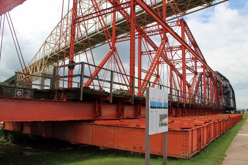
[English] The Emergency Swing Bridge Dam was built by the Dominion Bridge company of Montreal in 1896. The dam was modeled on the American Sault Canal dam, but the Canadian design was modified and the structure built entirely of steel. . . . — — Map (db m198477) HM
On Hub Trail at Canal Drive, on the right when traveling north on Hub Trail.
A Maine-born promoter, Clergue transformed Sault Ste. Marie into a major industrial centre. He purchased an unfinished hydroelectric station and canal at the Sault in 1894; then, lacking markets for his electric power, he created his own . . . — — Map (db m106374) HM
Explorer, interpreter, fur trader and diplomat, French-born Perrot played an important role in the establishment and protection of New France's western frontier during the last four decades of the 17th century. In 1671 he was with Saint-Lusson at . . . — — Map (db m105957) HM
On Foster Drive, 0.4 kilometers east of St Mary's River Drive, on the right when traveling east.
Until the mid-20th century, passenger and packet freighters were the most efficient means for transporting goods and people to and from isolated communities of the Upper Great Lakes. Essential to early regional development and instrumental in the . . . — — Map (db m105959) HM
Near Canal Drive, 0.7 kilometers south of Huron Street, on the right when traveling east.
Completed in 1895, this canal formed the last link in an all-Canadian navigation system stretching from the St. Lawrence River to Lake Superior. Designed and built by Canadians, the canal incorporated several engineering innovations. It was the . . . — — Map (db m106185) HM
On Canal Drive, 1 kilometer west of Huron Street, on the right when traveling west.
In May, 1870, Col. Garnet Wolseley arrived here with an expeditionary force of British regulars and Canadian militia aboard the steamer "Chicora". They were travelling to Fort Garry on the Red River to put down an uprising led by Louis Riel. The . . . — — Map (db m106362) HM
On Huron Street, 0.1 kilometers south of Canal Drive, on the right when traveling south.
The French explorers who first reached this favoured Ojibway hunting and fishing ground were soon followed by fur traders and missionaries who built a post and mission. By 1762 the region had come under British control and the trade eventually fell . . . — — Map (db m106412) HM
On Canal Drive, 1.1 kilometers west of Huron Street, on the left when traveling west.
[English] You are standing beside the world's last Emergency Swing Dam. Only nine of these structures were ever built. Only this one was put to the ultimate test under emergency conditions.
In a 1909 emergency, this dam was swung across . . . — — Map (db m198462) HM
Near Hub Trail, 0.1 kilometers east of Canal Drive, on the right when traveling east.
Travellers on the canoe route to the West had to make a portage around the St. Mary's rapids. The North West Company established a fur-trading post south of the river by 1791. After the British abandoned their occupation of the American midwest, . . . — — Map (db m106373) HM
On Canal Drive, 1.1 kilometers west of Huron Street, on the left when traveling west.
[English] On June 9th, 1909, the Emergency Swing Dam was called into action! On this day, the freighter Perry G. Walker crashed into the lock gates causing a rush of water from Lake Superior to flood into the canal. The force of the water was . . . — — Map (db m198469) HM
On Canal Drive, 1.1 kilometers west of Huron Street, on the left when traveling west.
[English] This steel structure looks like a bridge, but it is actually a dam. It is called the Emergency Swing Dam, since it was designed to swing out over the canal in an emergency and greatly slow the flow of water.
Only nine emergency . . . — — Map (db m198472) HM
On Broadway Avenue just north of Mackey Street, on the left when traveling north.
Francis Hector Clergue was the visionary who recognized that Wawa's resource rich wilderness was the fuel to feed an industrial empire in Sault Ste. Marie. Born in Brewer, Maine in 1856, Clergue was a dynamic man with boundless energy, . . . — — Map (db m218375) HM
Near Scenic High Falls Road (Pinewood Drive), 3.6 kilometers west of Trans-Canada Highway (Provincial Highway 17).
The Michipicoten Ojibway have a long history on the eastern shore of Lake Superior and Wawa area. Michipicoten is an Ojibway word which some say translates to "landing place" or "place of large hills". At the time of first contact with European . . . — — Map (db m218179) HM
On Broadway Avenue just north of Laurier Street, on the right when traveling north.
I think you would agree that the Wawa town site is situated in the perfect spot — a level plain on the shores of a picturesque lake of crystal green water surrounded by rolling mountains of natural abundance. Wawa's Ojibway ancestors, early . . . — — Map (db m218362) HM
Near Scenic High Falls Road (Pinewood Drive), 3.6 kilometers west of Trans-Canada Highway (Provincial Highway 17).
This site is dedicated to the members of the Rotary Club of Wawa who helped to develop, maintain and preserve the scenic beauty of Magpie High Falls for all to see and enjoy. 1963-1989 In 1989 this area was expanded into a permanent recreational . . . — — Map (db m218665) HM
Near Mission Road (Provincial Highway 101) just east of Trans-Canada Highway (Provincial Highway 17), on the left when traveling north.
The famous Wawa Goose gazes out over the Trans-Canada Highway as it carries traffic through the Magpie River Valley. Some sections of this roadway follow old native trails and wagon paths leading from Lake Superior, along the Magpie River to the . . . — — Map (db m218328) HM
Near Trans-Canada Highway (National Highway 17) 1.4 kilometers south of High Falls Road, on the right when traveling south.
The nearby Michipicoten River formed an important link in the canoe route from Lake Superior to James Bay via the Michipicoten, Missinaibi and Moose Rivers. The route was probably explored at an early date by the French Fur traders who maintained a . . . — — Map (db m199496) HM
On Broadway Avenue just south of Algoma Street, on the right when traveling north.
Wawa's Forest Fire Rangers — A massive forest fire in 1920 destroyed many of the buildings in Wawa City which were located further from the Lakeshore. In 1930 the Department of Lands and Forests established a Deputy Chief Ranger office on Wawa . . . — — Map (db m218582) HM
Near Scenic High Falls Road (Pinewood Drive), 3.6 kilometers west of Trans-Canada Highway (Provincial Highway 17).
Wawa's economy is based on our abundance of natural resources. Fur, fish, iron, gold, water and trees. The jumble of logs found at the base of Scenic High Falls are the remnants of Wawa's important logging history. Wood was first harvested along . . . — — Map (db m218600) HM
On Government Dock Road, 1 kilometer west of Michipicoten Harbour Road.
The weekly arrival of Captain Batten and the S.S. Caribou at Government Dock Beach at the mouth of the Michipicoten River was the highlight of early residents during the shipping season. Launched from her home port of Owen Sound in July 1904, the . . . — — Map (db m218556) HM
On Government Dock Road, 1 kilometer west of Michipicoten Harbour Road.
This beach received men & supplies for construction of the Canadian Pacific Railway in the 1880’s. In 1910 the Dominion Government & C.P.R. built a wharf and warehouse which were destroyed in the 1960’s. — — Map (db m218487) HM
On Michipicoten Harbour Road, 1.5 kilometers west of Queen Street, on the left when traveling west.
From this high bluff, on a clear northern day, you can see the vast expanse of Lake Superior and the dramatic coastline of Michipicoten Bay. This is one of the only accessible lookouts with a fantastic view of pristine Lake Superior, mysterious . . . — — Map (db m218668) HM
Near Superior Avenue, 0.6 kilometers west of Michipicoten River Village Road.
Michipicoten can be found on some of the earliest European maps created by early explorers of North America. One of the first official cartographers to put Michipicoten on the map was the English surveyor Philip Turnor. Born in the English . . . — — Map (db m218634) HM
On Michipicoten Harbour Road, 1.5 kilometers west of Queen Street, on the left when traveling west.
Born in Fribourg, Switzerland in 1807, Jean Louis Rodolphe Agassiz was a renowned scientist who studied medicine, philosophy, fossils, fish, rocks, plants and glaciers. During the height of his career, Professor Agassiz was one of the best known . . . — — Map (db m218293) HM
On Michipicoten Harbour Road, 0.8 kilometers west of Queen Street, on the left when traveling west.
Welcome to the centre of Canada's dynamic fur trade history for nearly 200 years. The Michipicoten First Nation's introduced the first European explorers to the rich fur-bearing forests of their home in the 1600's. Michipicoten was the ideal . . . — — Map (db m218187) HM
A Grand Legacy
In 1994, the Grand River was formally designated a Canadian Heritage River.
This honour recognizes rivers of outstanding significance and their important role in Canadian history. The Grand is unique, as it is the only . . . — — Map (db m240760) HM
A Brief History...
• 11,000 Years Ago - Nomadic hunter/ gatherer culture in tundra-like environment of the Grand River Valley.
• 9000 Years Ago - Hunter/gatherer culture begins to implement seasonal migratory camps.
The environment has . . . — — Map (db m240764) HM
On Cedar Trail at Lighthouse Road, on the right when traveling south on Cedar Trail.
[English] Built in 1859 by the Department of Public Works, this handsome 26 m structure is one of six “Imperial towers” on these shores. The circular limestone tower has walls 150 cm thick at the base, tapering to 61 cm at the top. The . . . — — Map (db m198318) HM
On River Line (County Route 39) just east of Communication Road (Ontario Highway 40), on the left when traveling east.
East of the Forks, the Thames River becomes shallower and not navigable for larger ships. With the American forces close behind, the British vessels were threatened with capture. One cargo ship, probably the Miamis, had already been set on fire . . . — — Map (db m71398) HM
Near William Street North just west of Murray Street, on the left when traveling north.
The Forks of the Thames are formed by the joining of the Thames River and McGregor Creek creating a peninsula that is present day Tecumseh Park in Chatham, Ontario. The strategic importance of the site was recognized by Lieutenant Governor John . . . — — Map (db m71331) HM
On Park Street just west of Cambridge Avenue, on the left when traveling west.
The Trueman Gibbens and the Clark Davis Boats were transported from Owen Sound by train and were assembled and launched in Lowbush in 1947 and 1951 respectively. Specifically designed for work in the shallow waters of Lake Abitibi of depths less . . . — — Map (db m245499) HM
Near Railway Street just west of 4th Avenue (Provincial Highway 101), on the left when traveling west.
The chute was a narrow, fast water part of the Black River located approximately 1.0 km above the highway 101 bridge. It was here that the MacDougall family and their friends set up an encampment during their journeys through the area. The chute . . . — — Map (db m244991) HM
On Simcoe Street South, 0.2 kilometers Lakeview Park Avenue, on the right when traveling south.
"A very busy and thriving neighbourhood the harbour must have been in the middle decades of the last century when the Lake was the principal highway, when a great part of what was brought in came to the wharf, as well as most of what was sent . . . — — Map (db m245234) HM
On King Street East at Ontario Street, on the left when traveling east on King Street East.
The Argyle was a passenger and freight steamer that docked at Sydenham Harbour in the early 1900’s. It operated between Toronto and Cobourg with stops in Whitby, Oshawa and Bowmanville. The return fare from Oshawa to Toronto was $1.00. Evening . . . — — Map (db m227898) HM
On Robinson Street just south of Pitt Street, on the right when traveling south.
The Port Burwell lighthouse was constructed in 1840. It was part of a national network of light stations equipped with beacon lights to warn or guide ships at sea. The Port Burwell light was used to aid navigation and commercial shipping of local . . . — — Map (db m198238) HM
Near Laird Avenue South just south of Elm Avenue, on the right when traveling south.
Detroit River Heritage
This river not only forms the border between two great nations, but is also a vital transportation artery into the upper Great Lakes. Imagine the vessels that have travelled on it … First National canoes, . . . — — Map (db m71160) HM
Near Laird Avenue South just south of Elm Avenue, on the right when traveling south.
Shoreline Breakwall
Over time, the force of water and ice has eroded the river bank, creating the need to stabilize the shore. Parks Canada, the Essex Region Conservation Authority (ERCA) and Environment Canada partnered to . . . — — Map (db m71161) HM
Near Laird Avenue South just south of Elm Avenue, on the right when traveling south.
Strategic Location
A deepwater channel between here and Boblo Island brings ships close to shore, a fact dramatically illustrated when a north-bound lake freighter passes by. This was why Fort Amerstburg was originally located . . . — — Map (db m71191) HM
In September 1813 the British squadron under R. Barclay sailed from Amherstburg to collect desperately needed food supplies. They were met by the larger, more heavily armed American squadron commanded by O. Perry. The British had the initial . . . — — Map (db m37707) HM
Near Lower Thames Lane just north of Harbour Drive when traveling north.
Construction of this Lighthouse by the Oartier family in 1818 and its predecessor. A frame structure destroyed by fire in the latter years of the War of 1812. Established an enduring landmark at the river mouth and a dynasty by the Oartler family as . . . — — Map (db m198365) HM
On Riverside Drive East at Riverside Avenue, on the right when traveling west on Riverside Drive East.
Served as the main navigational aid for the Great Lakes mariners using the Lake Erie Pelee Passage from 1902 to 1975.
The lighthouse was re-erected by Dean Construction Co. Ltd. on the present site as a gift to the City of Windsor.
In honour . . . — — Map (db m198379) HM
The Detroit River is unique in Canada, the United States and indeed, the world. Its shores embrace the largest metropolitan area on any international border - but rather than separating communities, the river connects them culturally and . . . — — Map (db m37378) HM
On 1st Avenue West at 8th Street West, on the left when traveling north on 1st Avenue West.
[English] In 1814-1816 the first Admiralty Survey of Lake Ontario and Georgian Bay was undertaken by Admiral William Fitzwilliam Owen, after whom Owen Sound is named. His successor, Admiral Henry Wolsey Bayfield, completed the first survey of . . . — — Map (db m198330) HM
This country estate is a fine example of 19th-century Picturesque landscape design. Developed in the 1840s by David Thompson, promoter of the Grand River Navigation Company, its buildings and grounds are carefully integrated to create . . . — — Map (db m230560) HM
On Port Maitland Road, 0.1 kilometers south of Dover Street, on the left when traveling south.
In 1815 the Royal Navy began building a depot on the
present site of Port Maitland. Though intended in the event of war to accommodate three frigates and 1,000 men, the base actually supported only the four schooners which then made up the . . . — — Map (db m231010) HM
On Walker Street, 0.2 kilometers east of Chisholm Street, on the right when traveling east.
History
The Battle of the Atlantic (September 1939 - May 1945)
The Second World War began when Nazi Germany invaded Poland. Britain, France, and Canada were quick to declare war, but the enemy was strong and well equipped. By the fall of . . . — — Map (db m237096) HM
On West Street, 0.1 kilometers south of Seneca Drive, on the right when traveling south.
Bronte Pioneer Cemetery is as much the victim of time and weather as the souls buried within it.
In 1830, Philip Sovereign deeded the east corner of his farm for a cemetery after several people had already been buried there. He specified that . . . — — Map (db m247162) HM
On Bronte Road, 0.1 kilometers north of Ontario Street, on the right when traveling south.
For nearly a century, commercial fishing was a way of life for the village of Bronte. In 1850, the mouth of Twelve Mile Creek resembled an Atlantic Coast outport. Fishing shanties lined the creek, nets hung on reels drying in the sun, and fish boats . . . — — Map (db m247113) HM
On Bronte Road, 0.1 kilometers north of Ontario Street, on the right when traveling east.
Unlike neighbouring Oakville, where by the late 1820s William Chisholm had financed a harbour privately, development of port facilities in Bronte was delayed until the founding of the Bronte Harbour Company.
Led by Samuel Bealey Harrison, a . . . — — Map (db m247149) HM
On Bronte Road, 0.1 kilometers north of Ontario Street, on the right when traveling east.
From the 1830s until after World War I, the Lake Ontario waterfront was busy with men mining the shallow waters for shale. Pried from the lake bottom, the blocks of shale were gathered on barges and then loaded onto stonehooking schooners for . . . — — Map (db m247158) HM
On Bronte Road, 0.1 kilometers north of Ontario Street, on the right when traveling east.
Between 1960 and 2000 yacht building flourished in Bronte and Oakville. In the 1970s as many as twenty major yachts a year were launched at Bronte Harbour.
Yacht manufacturers C&C, Ontario Yachts, Grampian and Bruckmann worked together with . . . — — Map (db m247157) HM
Near Confederation Drive east of Van Wagners Beach Road.
We honour here fifty-three sailors who lost their lives when their ships, HAMILTON and SCOURGE, capsized during a storm in the early morning hours of Sunday, 8th August 1813. These two armed merchant schooners lie in 90 metres of water, 30 . . . — — Map (db m56928) HM
On Confederation Drive, 0.7 kilometers south of Van Wagner’s Beach Road, on the left when traveling south.
The flashes of lightning were incessant, and nearly blinded me. Our decks seemed on fire, and yet I could see nothing. I heard no hail, no order, no call; but the schooner was filled with the shrieks and cries of the men...
Ned Myers' . . . — — Map (db m232634) HM
On Confederation Drive, 0.7 kilometers south of Van Wagner’s Beach Road, on the left when traveling south.
Hamilton & Scourge
The wrecks of the Hamilton and Scourge
are rare examples of vessels used during
the War of 1812. Designed as merchant
schooners, both were converted into
American warships once hostilities
began and each . . . — — Map (db m232638) HM
On Waterfront Trail, on the right when traveling north.
From the mid-1600s and the time of the early French explorers, ships have been sailing the Great Lakes. Since that time it is estimated more than 10,000 sunken ships have come to rest at the bottom of our Great Lakes.
Lake Ontario is no . . . — — Map (db m241435) HM
On East Street at Cootes Drive, on the right when traveling north on East Street.
In pioneer days waterways provided the essential means
of transportation. Dundas, located at the head of navigation on Lake Ontario and the eastern terminus of the Governor's Road", was thus in a favoured position. However, in 1823 the . . . — — Map (db m219998) HM
On King Street East, 0.3 kilometers east of East Street North, on the right when traveling east.
Peter Desjardins made it his life's work to develop viable canal route from Lake Ontario to Dundas
Desjardins came to Canada from France in 1792. He settled in Dundas in 1805 where he became Richard Hatt's chief clerk, Hatt envisioned a . . . — — Map (db m226479) HM
On Eastport Drive, 0.5 kilometers north of Beach Boulevard, on the left when traveling north.
BURLINGTON BAY CANAL
The first public work undertaken with the financial backing of the provincial government, Burlington Bay Canal was
proposed as one of a series of waterways to provide uninterrupted navigation from Lake Erie to the . . . — — Map (db m222843) HM
Near Eastport Drive, 0.4 kilometers north of Beach Boulevard, on the right when traveling north.
The Burlington Canal was completed in 1832. In 1837, the canal's first lighthouse shone its beacon across the lake. The wooden structure guided many ships into the canal.
George Thompson was the lighthouse's first keeper. His journal captured . . . — — Map (db m222838) HM
On Waterfront Trail/ E. Guise Street just north of Catherine Street, N. - Dock Service Road, on the right when traveling north.
HMCS Haida is the last of the Tribal class destroyers which saw heavy action with the Australian, British and Canadian navies during World War II. Built for the Royal Canadian Navy at Newcastle, England, , in 1942, this ship served on the frigid . . . — — Map (db m67343) WM
On Bay Street North at MacNab Street North, on the left when traveling east on Bay Street North.
The Royal Hamilton Yacht Club (RHYC) has long promoted a love of sailing throughout the community and beyond.
Aemilius Jarvis is widely thought of as the father of the Royal Hamilton Yacht Club. Jarvis was an important financier and . . . — — Map (db m227768) HM
On Cobourg Street just south of Lighthouse Street, on the right when traveling south.
The beacon at the top of the bluff is actually the second Goderich lighthouse, said to be built in 1847. The land was acquired by the Crown in March 1849, from Thomas Mercer Jones who kept a small house here. The first mention of the 'new' . . . — — Map (db m193012) HM
On Cobourg Street just west of Lighthouse Street, on the right when traveling west.
Goderich was the location of the first lighthouse erected on the Canadian side of Lake Huron.
1847 This tower was built by Scottish stonemason, Adam MacVicar. • It stands 10.1 metres high (about 33 feet) and 42.7 metres above the lake (about . . . — — Map (db m193008) HM
On Cobourg Street just east of Lighthouse Street, on the left when traveling east.
In a storm that struck Lake Huron on November 9, 1913,
ten lake freighters were lost. Seven of them vanished,
ranging from the 30-year-old, 270-foot "Wexford” to the
550-foot "James Carruthers", launched six months earlier at
Collingwood. The . . . — — Map (db m192995) HM
On West River Road (Duke Street) (Provincial Highway 594) at Earl Avenue, on the right when traveling east on West River Road (Duke Street).
The west shore of the river is about where nature made it. There was a waterfall where the dam and Duke Street Bridge are now, and an island at the east end of the present bridge. A second channel, also with a waterfall about where you are . . . — — Map (db m242997) HM
On West River Road (Duke Street) (Provincial Highway 594) at Earl Avenue, on the right when traveling east on West River Road (Duke Street).
Before World War II, most of the wood supply for the mill as well as the several saw mills which operated in Dryden was delivered by water. The wood was cut generally in the winter around the hundreds of miles of shore line of Lake Wabigoon and its . . . — — Map (db m242994) HM
Near Provincial Highway 17 at Florence Street, on the right when traveling south.
Dryden has been a center of the forest industry for over a century due to the availability of timber, its location on the Canadian Pacific Railroad and, before the existence of the power grid, the potential for power generation by the Wabigoon . . . — — Map (db m243085) HM
On West River Road (Duke Street) (Provincial Highway 594) at Earl Avenue, on the right when traveling east on West River Road (Duke Street).
About 1885 gold was discovered at Goldrock on the northern tip of Upper Manitou Lake about 30 miles southeast of here. A townsite was laid out in 1898 which grew to a town of 500 by its peak in 1908. At that time there were 5 gold mines operating . . . — — Map (db m243000) HM
On West River Road (Duke Street) (Provincial Highway 594) at Earl Avenue, on the right when traveling east on West River Road (Duke Street).
In the early 1900’s the best and strongest wrapping paper was made from Jack Pine using the Kraft process. The process used then required quantities of soap stone, and there are a number of soap stone mines in the Dryden area. The principal forest . . . — — Map (db m242993) HM
On West River Road (Duke Street) (Provincial Highway 594) at Earl Avenue, on the right when traveling east on West River Road (Duke Street).
The area just north of this point was originally an island and the east branch of the river. When the earth dam forming the base of Duke Street was built, the east branch of the river became a bay which was used for swimming. Later a small Hall . . . — — Map (db m242995) HM
On West River Road (Duke Street) (Provincial Highway 594) at Earl Avenue, on the right when traveling east on West River Road (Duke Street).
For 20 years Dryden turned its back on its waterfront, and the river no longer played a central role in the lives of the town. The wood disappeared from the river, and the paper mill retreated from the waters edge. The dilapidated boathouses . . . — — Map (db m242996) HM
Near Bernier Drive just south of Main Street South (Trans-Canada Highway) (Provincial Highway 17), on the right when traveling south.
Twenty year old Jacques de Noyon is believed to have been the first white man to reach the Lake of the Woods. The year — 1688. In 1717 De la Noue took the same route, up the Kaministiquia River, following a chain of lakes and streams to Rainy . . . — — Map (db m245138) HM
On Main Street South (Trans-Canada Highway) (Provincial Highway 17) just north of McClellan Avenue, on the left when traveling north.
Created by Dan Sawatzky of Chemainus, British Columbia, the mural is titled after a rowing term, “Riding the Flame”, which means the Herculean effort made by the rowers to propel their boats over the finish line in a competition. Featured in the . . . — — Map (db m245303) HM
Near Bernier Drive just south of Main Street South (Trans-Canada Highway) (Provincial Highway 17), on the right when traveling south.
Reception of the Marquis of Lorne, August 5, 1881 at the Lake of the Woods, Rat Portage Most of the 500-plus inhabitants of Rat Portage, including older Indians and French-Canadian voyageurs, waited along the waterfront behind today's Library, . . . — — Map (db m245165) HM
On Trans-Canada Highway (Provincial Highway 17) 0.4 kilometers east of Nethercutt Drive, on the right when traveling west.
On Old Fort Island a half mile north of here, the Hudson's Bay Company erected a stockaded fur trading post about 1836. This was the first known European structure within present Kenora. In 1861 the post was moved to the mainland, where it formed . . . — — Map (db m106495) HM
On Main Street South (Trans-Canada Highway) (Provincial Highway 17) just north of McClellan Avenue, on the left when traveling north.
Rat Portage (now Kenora) Rowing Club was founded in 1890. Its headquarters was built in 1892 on the current site of the Bank of Nova Scotia. Two of its most prominent members are portrayed here against the setting of the Rowing Club and . . . — — Map (db m245320) HM
Near Bernier Drive just south of Main Street South (Trans-Canada Highway) (Provincial Highway 17), on the right when traveling south.
The full name given in the charter is: “The Governor and Company of Adventurers of England, Trading into Hudson Bay”. The charter, granted by King Charles on May 2nd, 1670, gave the company “The Whole Trade of All Those Seas, Streights, and Bays, . . . — — Map (db m244997) HM
Near Lakeview Drive (Trans-Canada Highway) (Provincial Highway 17) 0.6 kilometers west of Bernier Drive (Veterans Drive), on the right when traveling west.
Who Was James McMillan?The namesake of the James McMillan tug boat — Mr. James A. McMillan — was a popular logging superintendent with the Ontario-Minnesota Pulp and Paper Company who died unexpectedly in 1942. McMillan was well . . . — — Map (db m245200) HM
On Main Street South (Trans-Canada Highway) (Provincial Highway 17) just south of McClellan Avenue, on the right when traveling south.
Created by Joyce Kamikura of Richmond, British Columbia, the painting features one of the major boat manufacturing companies on the Lake of the Woods and was a landmark on the Kenora waterfront until the late 1960’s. The Clipper was powered by a . . . — — Map (db m245233) HM
Near Bernier Drive just south of Main Street South (Trans-Canada Highway) (Provincial Highway 17), on the right when traveling south.
By Water Since Explorer Days By Rail Since 1882 By Road Since 1932 The Keenora: Built in Kenora in 1897, it was the largest steamer ever to operate on Lake of the Woods. It was 128 feet long with a beam of 28 feet. It’s 22 staterooms could . . . — — Map (db m244998) HM
1976 Olympic Cairn
Sailing - Montreal Games
Dedicated to the many Citizens
of Kingston and volunteers from
everywhere whose hard work
supported the Sailing Events held at
this venue, and who have supported
CORK Events since its inception
in . . . — — Map (db m207125) HM
The first Fort Henry was built during the War of 1812 to protect the British dockyards in Navy Bay. The present limestone citadel, constructed between 1832 and 1837, replaced the old fort as part of a larger plan for the defence of the recently . . . — — Map (db m39364) HM
This tower was constructed in 1846 as part of the new naval defenses authorized for Kingston Harbour by the Imperial Government during the Oregon Crisis of 1845-1846. It was one of the last British works of defense commenced in the . . . — — Map (db m208941) HM
On Fort Henry Drive close to Kingston Highway (Provincial Highway 2), on the left when traveling south.
English:
In memory of the officers and seamen of the Royal Navy and Provincial Marine, and the officers and soldiers on the Royal Marines, Royal Newfoundland, King’s (8th) and 100th Regiments, who served on Lake Ontario in defence of . . . — — Map (db m83620) WM
On Valour Drive at Point Frederick Drive, on the right when traveling east on Valour Drive.
English:
Born at Southampton, England, Yeo entered the British Navy, served throughout the Napoleonic Wars and won rapid promotion by his ability. In 1813, already a Commodore, he came to Canada to command British forces on the Great . . . — — Map (db m83616) HM
On Alexandria Avenue at Michigan Avenue, on the left when traveling north on Alexandria Avenue.
First ship to sail Lakes Erie, Huron and Michigan, the “Griffon”, probably 40- 45 feet long, was built by Robert Chavelier, Sieur de La Salle, several miles above Niagara Falls in 1679. La Salle came to New France in 1667, became seigneur of . . . — — Map (db m197805) HM
On Mill Street, 0.1 kilometers west of Little Bridge Street, on the right when traveling west.
The Mississippi River in eastern Ontario is a tributary of the Ottawa River. The upper basin starts in the Mazinaw Lake area and enters the Ottawa River above Chats Falls. Recognizing a need to manage the water flow, Mr. Jim Brown of Carleton Place . . . — — Map (db m104108) HM
On Mill Street just east of Bridge Street, on the left when traveling east.
The Town Hall Square forms the nucleus of the pioneer development along the Mississippi River and rapids. This environmentally important area, near the unique and significant stand of Hackberry Trees, has become the central part of the Town of . . . — — Map (db m234372) HM
On Mill Street just east of Bridge Street, on the left when traveling east.
The Ripple [Steamboat on Mississippi River] 1885
First Nations Harvesting of wild rice
Logging on the Mississippi
Men's War Canoe Team 1905
The Ballygiblin Riots 1824 — — Map (db m234374) HM
On Basin Street at Tay Street, on the right when traveling north on Basin Street.
The Tay Basin is a central depot for water travel on the Tay. In its youth, it aspired to become a major port for shipping and receiving goods, as it was linked to the newly finished Rideau Canal. The Tay's snies, creeks and swamps were . . . — — Map (db m207906) HM
On Basin Street at Tay Street, on the right when traveling north on Basin Street.
Perth merchants regularly used the Tay Canal between 1834 and 1850. Potash, timber and local produce were shipped to Montreal, and dry goods and manufactured articles were imported.
But the canal steadily fell into disrepair as soon . . . — — Map (db m208017) HM
On Basin Street at Tay Street, on the right when traveling north on Basin Street.
In the wilderness of 19th century Upper Canada, transportation was the key to settlement, growth and prosperity. Waterways, modified with locks and canals, were seen as the solution to many transportation problems. A feverish era of . . . — — Map (db m208032) HM
On Basin Street at Tay Street, on the right when traveling north on Basin Street.
The landscape in the Tay Basin has changed dramatically over the years. It has gone from an early settlers' campground to shipping docks and from residential housing to a market square.
Once called Perth Landing, its docks bustled with . . . — — Map (db m207886) HM
The three fountains in the Tay Basin are known as the International Friendship Fountains. They were installed in 2004, thanks to the Ontario Small Town and Rural
Economic Development Program (OSTAR-RED) and the generosity of the Rotary Club of . . . — — Map (db m207849) HM
On Basin Street at Tay Street, on the right when traveling north on Basin Street.
The British government established the first Military Settlement in Canada in March, 1816 at Perth upon Tay in response to continuing fears of an American invasion
following the War of 1812. A depot was established with a Superintendent's . . . — — Map (db m207948) HM
On Basin Street at Tay Street, on the right when traveling north on Basin Street.
Perth was created in 1816 as part of a grand British defence strategy which included the Rideau Canal and Fort Henry at Kingston. By 1822 Perth had burst into a vibrant frontier town, the new County Seat for the District of Bathurst . . . — — Map (db m208000) HM
On Basin Street at Tay Street, on the right when traveling north on Basin Street.
Enthusiasm for canals in 19th century Canada remained high despite the flurry of railway
construction after 1850. The government continued to maintain canals, including the Rideau Canal, to ensure their competitiveness. This kept alive . . . — — Map (db m208028) HM
On Mill Street just south of Market Street, on the right when traveling south.
Although it is hard to tell at a glance, there are no less than eight bridges connecting Cockburn and Haggart Islands to the mainland in Perth's downtown core - and each bridge has its own personality and history.
Locke's Bridge on . . . — — Map (db m233962) HM
Algonquin/Omàmìwinini People have lived on this river and in this territory for thousands of years. These waterways were elemental to people's seasonal lives, moving into the family's territories in the upper watersheds for the winter and . . . — — Map (db m207879) HM
280 entries matched your criteria. The first 100 are listed above. Next 100 ⊳