475 entries match your criteria. Entries 201 through 300 are listed.⊲ Previous 100 — Next 100 ⊳
Canada, Historic Sites and Monuments Board Historical Markers
Mandated to advise the Government of Canada, through the Minister of the Environment, on the commemoration of nationally significant aspects of Canada's history, the Board authorizes Parks Canada to install plaques inscribed with a bilingual text describing the historic significance of the subject. They are sometimes also written in a third language, particularly when the commemorated subject is linked to the history of Aboriginal peoples or ethnocultural communities.
On Hollis Street close to George Street, on the right when traveling south.
English
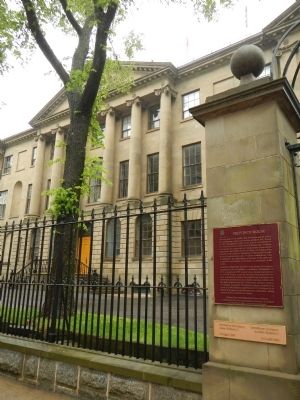
Province House is an architectural monument and the setting for signifiant events in Canadian political life. Begun in 1811 and opened in 1819 as the seat of government for Nova Scotia, it is one of the finest Palladian-style . . . — — Map (db m77858) HM
On Ta39 Road, 0.3 kilometers south of Point Pleasant Drive when traveling south.
English: Born in Halifax of Loyalist parentage, Cunard founded in the maritime provinces a commercial empire embracing banking, lumber, land, coal and, especially, shipping. Involved in transatlantic steam navigation from its early . . . — — Map (db m139202) HM
English
St. Mary’s holds a central position in the history of Roman Catholicism in Nova Scotia. Begun in 1820, the church demonstrated the enhanced ecclesiastical status of the province, which acquired its own Bishop in 1818, and witnessed . . . — — Map (db m77721) HM
Near Argyle Street just north of Prince Street, on the left when traveling south.
English:
Completed in 1750, St. Paul’s was the first church outside Great Britain to be designated as an Anglican cathedral. Between 1787 and 1864 it served as the cathedral church of the See of Nova Scotia. For 96 years St. . . . — — Map (db m139686) HM
On Spring Garden Road at Grafton Street, on the right when traveling east on Spring Garden Road.
English:
The Halifax Court House was designed in 1858 by the Toronto architectural firm of William Thomas and Sons and since its completion in 1863 has housed both county and provincial courts. The building’s importance is . . . — — Map (db m139600) HM
On Spring Garden Road just east of Grafton Street, on the right when traveling east.
English:
Born in Halifax and called to the bar in 1840, Henry represented Antigonish in the Nova Scotia Assembly as a Liberal (1841-57), and as a Conservative (1857-67). An ardent advocate of Confederation, he attended the . . . — — Map (db m139598) HM
Near Castine Way at Lord Dalhousie Drive, on the right when traveling east.
English:
A native of Kings County, Chase made his fortune as a shipper of potatoes and apples, warehouse developer and speculator in Annapolis Valley fruits. Active in the Nova Scotia Fruit Grower’s Association, he initiated apple . . . — — Map (db m141002) HM
Near Granville Street near Duke Street, in the median.
English:
The buildings on the north end of Granville Street were designed by the firm of William Thomas and Sons after a fire had razed the block in 1859. Erected in the Italianate Style for prosperous merchants, the structures . . . — — Map (db m139599) HM
Near York Redoubt Access Road, 0.2 kilometers south of Ferguson's Cove Road.
[English text]
York Redoubt was the heart of the defences protecting the outer harbour approaches to Halifax. Begun in 1793, it was enlarged by the Duke of Kent who constructed a Martello tower here in 1798. The redoubt became an essential . . . — — Map (db m44479) HM
The life story of Jeanne Dugas illustrates
the experiences of Acadíans in the second
half of the 18th century. She and her
family fled Ile Royale (Cape Breton Island)
to escape the deportation of 1758, but
were later captured by the . . . — — Map (db m139618) HM
Near Trans Canada Highway (National Route 104) 0.5 kilometers west of Ceilidh Trail (Route 19), on the right when traveling west.
English:
The foundation of this massive stone structure rests 66 metres below the Strait of Canso, creating the world’s deepest causeway. More than 9 million tonnes of rock fill were dumped into the strait between 1952 and 1955 . . . — — Map (db m139303) HM
Near Grand-Pré Road close to Old Post Road, on the left when traveling north.
English
The villages of Grand-Pré and Hortonville, and the fertile farmlands which surround them, comprise one of the oldest settlement and land use patterns of European origin in Canada. Acadians began settling near Grand-Pré in the 1680s, . . . — — Map (db m78721) HM
On Grand Pré Road at Old Post Road, on the right when traveling north on Grand Pré Road.
On February 11, 1747 Grand
Pré was the scene of a surprise
attack on Col. Arthur Noble's
detachment of British troops from
Massachusetts who were billeted
in the houses of the inhabitants.
A French and Indian force under
Coulon de . . . — — Map (db m140191) HM
Near Grand-Pré Road close to Old Post Road, on the left when traveling north.
English
The expulsion of the Acadians began in 1755, on the eve of the Seven Years’ War. Frustrated with the neutrality of the Acadians who refused to swear an unconditional oath of allegiance to the Crown, British forces began the . . . — — Map (db m78722) HM
In 1759, New England farmers and fishermen sent agents to Halifax to discuss with Governor Lawrence the settlement of the undeveloped areas of the province. Substantial immigration began in 1760 and, by late 1763, several thousand . . . — — Map (db m140207) HM
On Provost Street (Route 4) at Dalhousie Street, on the right when traveling south on Provost Street.
English:
Born and educated in New Glasgow, Cameron, having graduated from the Boston Law School, practiced law in the United States before joining Queen’s University in 1882. The following year he became editor of the Kingston . . . — — Map (db m139298) HM
Near North Foord Street (Nova Scotia Route 374) 0.2 kilometers south of Trans-Canada Highway (National Route 104), on the left when traveling south.
English:
This British firm established coal mining as a major industry in Nova Scotia. Granted a monopoly of provincial mineral rights in 1826, the GMA developed coal operations here at Albion Mines and at Sydney Mines, and . . . — — Map (db m140077) HM
This house, built between 1814 and 1823 by Charles Ermatinger of the North West Company, is the oldest surviving house in northwestern Ontario. Constructed when Sault Ste. Marie was still a small fur trading post on the Upper Lakes, this fine house . . . — — Map (db m105955) HM
On Hub Trail at Canal Drive, on the right when traveling north on Hub Trail.
A Maine-born promoter, Clergue transformed Sault Ste. Marie into a major industrial centre. He purchased an unfinished hydroelectric station and canal at the Sault in 1894; then, lacking markets for his electric power, he created his own . . . — — Map (db m106374) HM
Explorer, interpreter, fur trader and diplomat, French-born Perrot played an important role in the establishment and protection of New France's western frontier during the last four decades of the 17th century. In 1671 he was with Saint-Lusson at . . . — — Map (db m105957) HM
On Foster Drive, 0.4 kilometers east of St Mary's River Drive, on the right when traveling east.
Until the mid-20th century, passenger and packet freighters were the most efficient means for transporting goods and people to and from isolated communities of the Upper Great Lakes. Essential to early regional development and instrumental in the . . . — — Map (db m105959) HM
Near Canal Drive, 0.7 kilometers south of Huron Street, on the right when traveling east.
Completed in 1895, this canal formed the last link in an all-Canadian navigation system stretching from the St. Lawrence River to Lake Superior. Designed and built by Canadians, the canal incorporated several engineering innovations. It was the . . . — — Map (db m106185) HM
On Huron Street, 0.1 kilometers south of Canal Drive, on the right when traveling south.
The French explorers who first reached this favoured Ojibway hunting and fishing ground were soon followed by fur traders and missionaries who built a post and mission. By 1762 the region had come under British control and the trade eventually fell . . . — — Map (db m106412) HM
On Mission Road (National Highway 101) 0.5 kilometers north of Trans-Canada Highway (National Highway 17), on the right when traveling south.
[English] This highway's construction from St. John's to Victoria between 1949 and 1970 was a great feat of engineering, linking the provinces of this vast country. Here, in 1960, near the halfway point of the 7,821 kilometre-long . . . — — Map (db m199454) HM
Near Mohawk Street close to Morrison Road, on the left when traveling west.
English: Originally called St. Paul's, this chapel was the first Protestant church in Upper Canada and is now the oldest surviving church in Ontario. Built by the Crown in 1785, it was given to those Mohawk Indians led by Joseph Brant who . . . — — Map (db m83743) HM
On West Street just north of Chatham Street, on the left when traveling north.
[English] Pioneering journalist in the late 19th century, Sara Jeannette Duncan challenged social and political norms by examining women’s changing roles, the need for a national culture, and the way Canadian politics . . . — — Map (db m215697) HM
On Tutela Heights Road, 0.8 kilometers east of Mount Pleasant Road, on the left when traveling east.
The Bell Homestead
Here at his parents' home in July 1874, Alexander Graham
Bell conceived the fundamental idea of the telephone and, in August 1876, carried out the first successful long-distance trials. The Homestead evokes the . . . — — Map (db m230331) HM
On Tutela Heights Road, 0.8 kilometers east of Mount Pleasant Road, on the left when traveling east.
Invention of the Telephone
Even here at his father's home where he came for rest
and peace, Alexander Graham Bell continued to ponder
the elusive secret of voice transmission, and it was here,
on 26 July 1874, that insight finally . . . — — Map (db m230396) HM
On West Street just north of Wellington Street, on the right when traveling north.
[English] An outstanding sculptor of some of Canada's finest public monuments, Walter Allward is best known for his masterpiece, the Vimy war memorial in France. He emerged as a dominant figure in the transition from . . . — — Map (db m215699) HM
Near County Highway 54 just east of Chiefswood Road, on the right when traveling east.
[English] Completed in 1856, Chiefswood owes its importance to its architecture and the prominence of the people who lived here. Derived from the popular Italianate style of the Picturesque movement, the grandeur of the house . . . — — Map (db m209067) HM
Near County Highway 54 just east of Chiefswood Road, on the right when traveling east.
[English] Born here at Chiefswood, the daughter of a Mohawk chief, E. Pauline Johnson gained international fame for her romantic writings on Indian themes, but she also wrote about nature, religion and Canadian nationalism. . . . — — Map (db m209066) HM
Near 4th Line close to Chiefswood Road, on the left when traveling west.
English:
This celebrated Mohawk chief of Canajoharie Castle and Johnson Hall grew up in the Mohawk Valley. He received his baptism of fire at the battle of Lake George in 1755. He served with Sir William Johnson in the Niagara . . . — — Map (db m83714) HM
Near 4th Line close to Chiefswood Road, on the left when traveling west.
English:
Commemorating the loyal services and unswerving fidelity of the Six Nations of Iroquois Indians to the British Empire in the Seven Years War, 1755 - 1763, the War of the American Revolution, 1775 - 1783, and in the defence of . . . — — Map (db m83712) HM
On Blue Lake Road (County Road 35) 0.6 kilometers west of Brant Road (Provincial Highway 24), on the right when traveling west.
[English] Born in Ontario, Adelaide Hoodless sought to release the full potential of women for social action. An outspoken educator and social reformer, she successfully pressed for acceptance of Domestic Economy as a subject for . . . — — Map (db m208860) HM
On Cedar Trail at Lighthouse Road, on the right when traveling south on Cedar Trail.
[English] Built in 1859 by the Department of Public Works, this handsome 26 m structure is one of six “Imperial towers” on these shores. The circular limestone tower has walls 150 cm thick at the base, tapering to 61 cm at the top. The . . . — — Map (db m198318) HM
On Riverview Line (County Route 36) 2 kilometers west of Bloomfield Road, on the left when traveling east.
Following the defeat of the British at the Battle of the Thames on October 5, 1813, American forces controlled the Thames Valley west of Moraviantown. In early December a detachment of 3 officers and 36 men of the American 26th Regiment established . . . — — Map (db m71292) HM
On King Street East just east of Prince Street South, on the left when traveling east.
From 1783 until the 1860s, abolitionists in British North America took part in the fight to end slavery both at home and in the United States. Thanks to the determination of colonial officials, anti-slavery organizations, and the thousands of . . . — — Map (db m71391) HM
On Uncle Tom's Road at Park Street, on the right when traveling north on Uncle Tom's Road.
After escaping to Upper Canada from slavery in Kentucky, the Reverend Josiah Henson became a conductor of the Underground Railroad and a force in the abolition movement. The founder of the Black settlement of Dawn, he was also an . . . — — Map (db m78377) HM
On Longwoods Road south of County Highway 18, on the right when traveling east.
(Front of monument)
Fairfield on the Thames / Fairfield sur la Thames
Here stood the village of Fairfield, destroyed by invading American forces following the Battle of the Thames. , 5th October, 1813.
Its inhabitants, Delaware . . . — — Map (db m116758) HM
On Longwoods Road (Provincial Highway 2) 4.2 kilometers east of Victoria Road (Provincial Highway 21), on the right when traveling east.
Born in a Shawnee village in what is now Ohio, Tecumseh became in the 1770s co-leader with his brother, the Prophet, of a movement to restore and preserve traditional Indian values. He believed a union of all the western tribes to drive back white . . . — — Map (db m71410) HM
Near 2nd Avenue at Brunette Road, on the right when traveling south.
[English] After the Cariboo and Klondike rushes, gold production in Canada entered a new era with the discovery of lode deposits in the Porcupine area in 1909. The mines in this district, notably the Hollinger which became one of . . . — — Map (db m199247) HM
On Durham Regional Road 1 (Concession Road 7) just north of Leaskdale Road, on the right when traveling north.
[English] From 1911 to 1926, this Presbyterian manse was home to Lucy Maud Montgomery, the world-famous author whose writing career was launched in Prince Edward Island. Here at Leaskdale she began her role as a wife and mother, and . . . — — Map (db m199578) HM
Near Simcoe Street North (Durham Regional Road 2) just south of Parkwood Court, on the right when traveling south.
[English] A rare surviving example of the grand estates of the inter-war years, Parkwood consists of a richly decorated house set in 12 acres of grounds. The house, originally constructed in 1916-1917 to the designs of the Toronto . . . — — Map (db m208899) HM
Near Simcoe Street North (Durham Regional Road 2) just south of Parkwood Court, on the right when traveling south.
[English] A famous industrialist and philanthropist, “Colonel Sam” McLaughlin was a founder of the automotive industry in Canada. Involved in the design and manufacture of carriages and sleighs for his family business, he foresaw . . . — — Map (db m208898) HM
[West Historic Marker]:Amherstburg Navy Yard
A Navy Yard was built here in 1796 to replace Detroit as the base and supply depot for the Provincial Marine on Lakes Erie and Huron. In 1812 the GENERAL HUNTER and QUEEN CHARLOTTE, built . . . — — Map (db m37552) HM
On Laird Avenue South south of Elm Avenue, on the right when traveling south.
The post was begun by the Royal Canadian Volunteers in 1796 to replace Detroit and to maintain British influence among the western Indians. As the principal defense of the Detroit frontier in 1812, it was here that Isaac Brock gathered his forces . . . — — Map (db m34353) HM
Near Laird Avenue South close to Elm Avenue, on the right when traveling south.
Born at Queenston in Upper Canada, John Richardson served as a volunteer at Fort Malden during the War of 1812 and was taken prisoner by the Americans at Moraviantown. He was released at war's end, retired on half-pay in 1818, and spent most of the . . . — — Map (db m76737) HM
On Front Road North north of County Route 10, on the right when traveling south.
This area was once the home of the Wyandot, remnants of the Huron, Neutrals, and Petuns who were dispersed by the Iroquois in the 1640's. Some eventually reunited and settled along the Detroit River, where they became known as the Hurons of Detroit, . . . — — Map (db m37340) HM
On Riverside Drive East west of Walker Road, on the left when traveling east.
Massachusetts born, Hiram Walker had by the 1850s become a successful general merchant, distiller and grain dealer in Detroit. After Michigan adopted prohibition in 1855 he acquired land across the river in Canada where he established a distillery . . . — — Map (db m37377) HM
On Sandwich Street at Ojibway Parkway, on the right when traveling south on Sandwich Street.
Confident of victory, General Hull had invaded Canada in July 1812, but failed to take advantage of his early success and the demoralization of the defenders. Fear of the Indians then rallying to the British cause and an inability to maintain supply . . . — — Map (db m34321) HM
On Pitt Street West west of Ferry Street, on the right when traveling west.
This house and adjacent farmland were the property of François Baby (1763-1856), first member for Kent in the Legislative Assembly of Upper Canada (1792-96), militia officer and Assistant Quarter Master General during the War of 1812. When the . . . — — Map (db m34303) HM
From the early 19th century until the American Civil War, settlements along the Detroit and Niagara rivers were important terminals of the Underground Railroad. White and black abolitionists formed a heroic network dedicated to helping free and . . . — — Map (db m37379) HM
On Valour Drive close to Point Frederick Drive, on the left when traveling east.
English: This peninsula, headquarters of the Provincial Marine (c. 1790-1813), and of the Royal Navy (1813-1853), was the major British naval base on Lake Ontario during the War of 1812. Buildings surviving from this period include the Naval . . . — — Map (db m83618) HM
Near King Street East at West Street, on the right when traveling west.
English:
This Kingston lawyer was the chief architect of Confederation, which led to the creation of the Dominion of Canada on July 1st, 1867. He was Canada's first Prime Minister and led the country for almost 19 years. The . . . — — Map (db m140200) HM
On 1st Avenue West at 8th Street West, on the left when traveling north on 1st Avenue West.
[English] In 1814-1816 the first Admiralty Survey of Lake Ontario and Georgian Bay was undertaken by Admiral William Fitzwilliam Owen, after whom Owen Sound is named. His successor, Admiral Henry Wolsey Bayfield, completed the first survey of . . . — — Map (db m198330) HM
This country estate is a fine example of 19th-century Picturesque landscape design. Developed in the 1840s by David Thompson, promoter of the Grand River Navigation Company, its buildings and grounds are carefully integrated to create . . . — — Map (db m230560) HM
This important botanical garden is distinguished by its first class horticultural collection. Originating in the late 1920s, it developed as a series of discrete gardens and a wildlife conservation area within an urban context. Some of . . . — — Map (db m221298) HM
On York Boulevard just north of Dundurn Street North, on the right when traveling north.
[English Text]:
Here in June, 1813, General John Vincent assembled troops that made the successful night attack on the invaders at Stoney Creek. From this point of vantage, in December, 1813, the force which retook Fort George and . . . — — Map (db m56725) HM
Near York Boulevard just north of Dundurn Street North, on the right when traveling north.
This villa was completed in 1835 for Allan Napier MacNab. Incorporating an existing farmhouse, it was designed by the local architect, Robert Wetherell, as a statement of its owner's place in Hamilton society. The house features an eclectic blend . . . — — Map (db m66126) HM
Near York Boulevard just north of Dundurn Street North, on the right when traveling north.
Politician, businessman, land speculator and soldier, Allan MacNab enjoyed a very public life. He was a successful lawyer and was appointed Upper Canada's first Queen's Counsel. In 1838 he was knighted for his role in suppressing the rebellion in . . . — — Map (db m66130) HM
On Stuart Street, 0.1 kilometers east of Bay Street North, on the right when traveling east.
[English] The former Customs House (1858-1860) is a fine example of the Italianate style of architecture which was popular in Canada from the 1840s through the 1870s. Inspired by Renaissance palazzi of Rome and Florence, Italianate buildings . . . — — Map (db m196259) HM
On James Street North at Murray Street East, on the right when traveling north on James Street North.
[English] This building recalls the importance of the railway to the development of Canada's industrial cities. Completed in 1931, it combines a strong classical design with a fluid circulation plan, making it one of the best urban stations . . . — — Map (db m196260) HM
On James Street North, 0.1 kilometers north of Cannon Street East, on the right when traveling north.
JOHN WEIR FOOTE ARMOURY
The north section of this building
(1887-1888) is a rare surviving example
of the second wave of armoury
construction in Canada. Designed
by Henry James, it exemplifies the
replacement of earlier wooden . . . — — Map (db m218780) HM
On Confederation Drive, 0.7 kilometers south of Van Wagner’s Beach Road, on the left when traveling south.
Hamilton & Scourge
The wrecks of the Hamilton and Scourge
are rare examples of vessels used during
the War of 1812. Designed as merchant
schooners, both were converted into
American warships once hostilities
began and each . . . — — Map (db m232638) HM
On The Governor’s Road, 0.1 kilometers east of Bridelwood Drive, on the left when traveling west.
DUNDAS STREET
Dundas Street, named for Henry Dundas, Secretary of State for the British Home Department (1791-1794), was built on Lieutenant Governor Simcoe's orders in 1793-1794. The road, cut by a party of Queen's Rangers from . . . — — Map (db m220871) HM
On Duke Street at MacNab Street South, on the left when traveling west on Duke Street.
Built about 1856, at a time of rapid growth in Hamilton, Sandyford Place is a fine example of the housing then being erected for the merchants of the period. It is a rare survivor in Canada of the few row
houses built for affluent . . . — — Map (db m218512) HM
On James Street South at Jackson Street West, on the right when traveling south on James Street South.
Erected in 1854-1857, St. Paul's (formerly St. Andrew's) is an elegant example of the Gothic Revival style. The design of the church shows the influence of the Ecclesiological Movement which favoured plans based on English medieval . . . — — Map (db m218245) HM
Near Jackson Street West, 0.1 kilometers west of Jackson W. and MacNab S., on the left when traveling west.
Set in a rare walled garden and enriched by its interior decoration, Whitehern is a remarkably intact example of mid-19th century residential architecture. The lingering influence of the Palladian style combined with Neoclassical motifs . . . — — Map (db m218635) HM
On Waterfront Trail/ E. Guise Street just north of Catherine Street, N. - Dock Service Road, on the right when traveling north.
HMCS Haida is the last of the Tribal class destroyers which saw heavy action with the Australian, British and Canadian navies during World War II. Built for the Royal Canadian Navy at Newcastle, England, , in 1942, this ship served on the frigid . . . — — Map (db m67343) WM
On Woodward Avenue, 0.3 kilometers south of Nikola Tesla Boulevard, on the right when traveling north.
The Hamilton Waterworks
This dignified building, reminiscent of the style of a Roman aqueduct, houses one of Canada's greatest surviving engineering achievements of the mid-19th century, the Hamilton Waterworks. Built between 1857 . . . — — Map (db m227140) HM
Near King Street West east of Centennial Parkway South.
[English Text]: Battle of Stoney Creek
During 1813 the Americans planned to invade Upper Canada from Detroit and the Niagara Peninsula. In late May, an American force crossed the Niagara River, seized Fort George, and with about . . . — — Map (db m56762) HM
On 35 Centre Street, on the right when traveling north.
Built about 1840, Bellevue House is one of the most interesting examples surviving in Canada of "Italian Villa" architecture, a style that was new in the country and novel in Kingston. This type of residence subsequently became popular . . . — — Map (db m207210) HM
Near King Street East just west of West Street, on the right when traveling west.
English:
In September 1783, Deputy Surveyor-General John Collins was despatched to Cataraqui by Governor Haldimand to lay out townships for loyalist settlers. The necessary land was purchased from Mississauga Indians, and on 27 . . . — — Map (db m140199) HM
In English:
An earlier fort was built here on Point Henry during the War of 1812 primarily to defend the nearby naval dockyard. When the Rideau Canal was built as part of a military route connecting Kingston with Montreal, the strategic . . . — — Map (db m39363) HM
On Court Street east of Barrie Street, on the left when traveling east.
English:
This grand Neo-classical building has served the courts of Frontenac County since its opening in 1858. Designed by the Dorset-born architect, Edward Horsey, it is superbly sited on land originally acquired in 1840 for a . . . — — Map (db m140193) HM
On King Street East at Clarence Street, on the left when traveling north on King Street East.
English:
Designed by the Montréal architectural firm of Hopkins, Lawford and Nelson, the Kingston Custom House was built in 1856-59 for the government of the united Canadas. The symmetrical composition of the two-storey ashlar . . . — — Map (db m140194) HM
On Point Frederick Drive, on the right when traveling south.
English: The Navy Yard established in 1789 as a trans-shipment point for the Great Lakes and as the Provincial Marine's Lake Ontario base was administered by the Admiralty after 1813. During the War of 1812 Commodore James Yeo, R. N., . . . — — Map (db m83568) HM
On King Street West close to Sir John A Macdonald Blvd, on the right when traveling east.
Opened on 1 June 1835, Kingston Penitentiary is Canada's oldest
reformatory prison. Its layout-an imposing front gate leading to a cross-
shaped cellblock, with workshops to the rear-was the model for other federal
prisons for more . . . — — Map (db m205090) HM
On Clarence Street just east of Wellington Street, on the right when traveling east.
English:
In 1856-59 the government of the united Canadas erected the Kingston Post Office. Designed by the Montreal architectural firm of Hopkins, Lawford and Nelson, this limestone building shows the influence of the British . . . — — Map (db m140197) HM
This tower was constructed in 1846 as part of the new naval defenses authorized for Kingston Harbour by the Imperial Government during the Oregon Crisis of 1845-1846. It was one of the last British works of defense commenced in the . . . — — Map (db m208941) HM
On Fort Henry Drive close to Kingston Highway (Provincial Highway 2), on the left when traveling south.
English:
In memory of the officers and seamen of the Royal Navy and Provincial Marine, and the officers and soldiers on the Royal Marines, Royal Newfoundland, King’s (8th) and 100th Regiments, who served on Lake Ontario in defence of . . . — — Map (db m83620) WM
On Valour Drive at Point Frederick Drive, on the right when traveling east on Valour Drive.
English:
Born at Southampton, England, Yeo entered the British Navy, served throughout the Napoleonic Wars and won rapid promotion by his ability. In 1813, already a Commodore, he came to Canada to command British forces on the Great . . . — — Map (db m83616) HM
On King Street East at Market Street, on the left when traveling north on King Street East.
English:
Because of the Loyalist influx into the western part of Quebec after the American Revolution, the province was divided into Upper and Lower Canada (now Ontario and Quebec). The Constitutional Act of 1791 provided for . . . — — Map (db m140198) HM
Near Kelly Road close to Gum Bed Line, on the left when traveling south.
English
The presence of oil in this locality was observed by early travelers and by the pioneer farmers who used it for medical purposes. In 1858, near Oil Springs, James M. Williams dug the first oil well in Canada and later established a . . . — — Map (db m78424) HM
On Greenfield Street close to Petrolia Line, on the right when traveling south.
English When Victoria Hall was built in 1889, Petrolia, in the midst of an oil boom, was one of the wealthiest towns in Canada. The opulent town hall reflects this stage in the town’s growth. While its first floor housed municipal offices, . . . — — Map (db m78421) HM
On Mill Street at Little Bridge Street, on the right when traveling west on Mill Street.
Begun in 1889 and finished in 1891, this building was erected to house postal and customs services. Federal chief architect Thomas Fuller was responsible for the design and Robert Cameron was the contractor. The building was part of a national . . . — — Map (db m104019) HM
Near Ramsay Concession 8, 1.7 kilometers north of Clayton Road.
Surgeon, educator and sculptor, McKenzie was born in Lanark County, Ontario. After graduating in medicine at McGill University, he became its Medical Director of Physical Training in 1894. A pioneer in physical education, he served as a surgeon . . . — — Map (db m104096) HM
On Gore Street East just east of Foster Street, on the left when traveling east.
Built in 1840 of local sandstone, the Matheson House is an outstanding example of early Scottish-Canadian architecture. Its design is imposing, its stonework remarkably fine, and it
occupies a key position in one of the best surviving . . . — — Map (db m233817) HM
On Harvey Street at Gore Street East (County Highway 43), on the right when traveling north on Harvey Street.
Begun in 1830 for barrister Daniel McMartin (1798-1869), this imposing house symbolizes the wealth and social aspirations of this member of the Tory elite. Born at Williamsburg of Loyalist stock, McMartin attended John Strachan's . . . — — Map (db m207662) HM
On Gore Street East (County Highway 43) at Market Square, on the left when traveling west on Gore Street East.
Perth's stately town hall is an enduring expression of the vitality and importance of local governments in the 19th century. Erected in 1863-1864, shortly after the town's
incorporation, it recalls an era when such buildings served as . . . — — Map (db m207771) HM
On Court House Avenue (County Route 29) at William Street, on the right when traveling south on Court House Avenue.
Completed in 1886 this structure was designed under the direction of Thomas Fuller, Chief Architect of the Department of Public Works from 1881 to 1896. The Brockville Post Office shows the sensitivity often displayed by Fuller and his staff. The . . . — — Map (db m87064) HM
Built in 1899 – 1900, this eclectic mansion evokes the opulent lifestyle of Canada’s industrial elite at the turn of the century. Designed by American architect A. W. Fuller, it was the spacious residence of Senator George T. Fulford (1852–1905), . . . — — Map (db m87017) HM
On Court House Square, on the left when traveling east.
Symbols of law and authority to a new and changing society, the district court houses of Upper Canada were architecturally prominent buildings in the colony. Of these, one of the most grandiose is the former Johnstown District court house which was . . . — — Map (db m87027) HM
On Court House Square, on the left when traveling east.
Born at Brockville and called to the bar of Upper Canada in 1837, Richards represented Leeds in the Legislative Assembly (1848–53) and served as Attorney General for Canada West in the Hincks-Morin administration (1851–3). Appointed puisne judge of . . . — — Map (db m87029) HM
On Thousand Islands Parkway at Darlingside Drive, on the right when traveling east on Thousand Islands Parkway.
Darlingside is a rare surviving example of the wood depots which provided an essential fuelling service during the early phase of steamboat navigation on Lake Ontario and the upper St. Lawrence River. Thomas Darling, a Scottish immigrant, . . . — — Map (db m102088) HM
On Stone Street South close to Pine Street, on the right when traveling south.
English:
A vulnerable point on the vital line of supply from Lower Canada in the War of 1812-14. Raided on the 21st September, 1812, when the bridge was broken up. Fortified by the Leeds Militia and garrisoned in turn by the 104th, 41st, . . . — — Map (db m83528) HM
On Cook Street at Lyndhurst Road, on the right when traveling south on Cook Street.
While the existence of local ore was well known and various petitions
had been made for the right to erect a foundry, it was not until
1801 that Wallis Sunderlin, a Vermont founderer, established the first
iron works in Upper Canada . . . — — Map (db m244304) HM
On St. Lawrence Street (Provincial Highway 15/43) at Rideau Canal, on the right when traveling south on St. Lawrence Street.
When construction of the Rideau Canal began, Merrickville was already an established village and was considered by the authorities to be a logical target for an invader. Consequently Colonel John By urged strong measures for the . . . — — Map (db m142194) HM
On Railway Avenue at St-Lawrence Street, on the right when traveling west on Railway Avenue.
The Grand Trunk was incorporated in 1853 to run from Sarnia to Portland, Maine. Although it took over existing lines, new ones had to be built, including sections of the key Toronto to Montréal line completed by the noted English . . . — — Map (db m45781) HM
On Loyalist Parkway (Provincial Highway 33), on the right when traveling east.
English: In the early 1800's Kingston was a shipbuilding centre of note. The FRONTENAC, the first steamship to navigate Lake Ontario, was built here at Finkle's Point, Ernestown (now Bath), and launched September 7, 1816. Designed to carry . . . — — Map (db m83645) HM
475 entries matched your criteria. Entries 201 through 300 are listed above. ⊲ Previous 100 — Next 100 ⊳