By Duane Marsteller, August 5, 2017
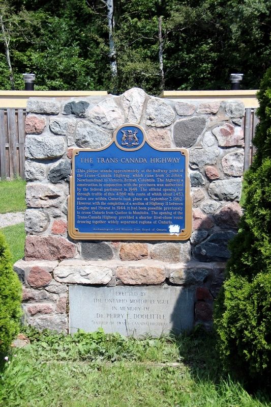
The Trans-Canada Highway Marker
| On Trans-Canada Highway (Provincial Highway 17) 0.8 kilometers west of Whispering Pines Road, on the right when traveling west. |
| On Trans-Canada Highway (Provincial Highway 17) at Taylor Street, on the right when traveling east on Trans-Canada Highway. |
| On Trans-Canada Highway (Provincial Highway 17) 1.5 kilometers west of Kensington Road, on the right when traveling west. |
| On Bay Street, 0.2 kilometers south of Dennis Street, on the right when traveling south. |
| On St Mary's River Drive, 0.2 kilometers west of Foster Drive, on the right when traveling south. |
| Near Lake Street, 0.6 kilometers south of Queen Street East. |
| On Foster Drive, 0.4 kilometers east of St Mary's River Drive, on the right when traveling east. |
| On Canal Drive, 1.2 kilometers west of Huron Street, on the left when traveling west. |
| Near Bay Street at Pim Street. |
| On Hub Trail at Canal Drive, on the right when traveling north on Hub Trail. |
| On Albert Street East at Elgin Street, on the right when traveling north on Albert Street East. |
| Near Bay Street at East Street. |
| On Foster Drive, 0.4 kilometers east of St Mary's River Drive, on the right when traveling east. |
| On Queen Street East at East Street, on the right when traveling north on Queen Street East. |
| On Queen Street East, 0.2 kilometers west of Pim Street, on the right when traveling west. |
| Near Canal Drive, 0.7 kilometers south of Huron Street, on the right when traveling east. |
| On Queen Street East, 0.2 kilometers west of Riverside Drive, on the right when traveling west. |
| On Canal Drive, 1 kilometer west of Huron Street, on the right when traveling west. |
| On Huron Street, 0.1 kilometers south of Canal Drive, on the right when traveling south. |
| On Canal Drive, 1.1 kilometers west of Huron Street, on the left when traveling west. |
| Near Hub Trail, 0.1 kilometers east of Canal Drive, on the right when traveling east. |
| On Canal Drive, 1.1 kilometers west of Huron Street, on the left when traveling west. |
| On Canal Drive, 1.1 kilometers west of Huron Street, on the left when traveling west. |
| On Lakeside Drive just north of Stanley Street, on the right when traveling north. |
| Near Mission Road (Provincial Highway 101) just east of Trans-Canada Highway (Provincial Highway 17), on the left when traveling north. |
| Near Mission Road (Provincial Highway 101) just east of Trans-Canada Highway (Provincial Highway 17), on the left when traveling north. |
| On Broadway Avenue just north of Mackey Street, on the left when traveling north. |
| Near Mission Road (Provincial Highway 101) just east of Trans-Canada Highway (Provincial Highway 17), on the left when traveling north. |
| On Broadway Avenue just north of Mackey Street, on the left when traveling north. |
| Near Mission Road (Provincial Highway 101) just east of Trans-Canada Highway (Provincial Highway 17), on the left when traveling north. |
| On Mission Road (National Highway 101) 0.5 kilometers north of Trans-Canada Highway (National Highway 17), on the left when traveling north. |
| On Mission Road (National Highway 101) 0.5 kilometers north of Trans-Canada Highway (National Highway 17), on the right when traveling south. |
| On Broadway Avenue just north of Mackey Street, on the left when traveling north. |
| Near Scenic High Falls Road (Pinewood Drive), 3.6 kilometers west of Trans-Canada Highway (Provincial Highway 17). |
| Near Scenic High Falls Road (Pinewood Drive), 3.6 kilometers west of Trans-Canada Highway (Provincial Highway 17). |
| Near Mission Road (Provincial Highway 101) just east of Trans-Canada Highway (Provincial Highway 17), on the left when traveling north. |
| Near Mission Road (Provincial Highway 101) just east of Trans-Canada Highway (Provincial Highway 17), on the left when traveling north. |
| Near Mission Road (Provincial Highway 101) just east of Trans-Canada Highway (Provincial Highway 17), on the left when traveling north. |
| Near Mission Road (Provincial Highway 101) just east of Trans-Canada Highway (Provincial Highway 17), on the left when traveling north. |
| Near Scenic High Falls Road (Pinewood Drive), 3.6 kilometers west of Trans-Canada Highway (Provincial Highway 17). |
| On Broadway Avenue just north of Mackey Street, on the left when traveling north. |
| Near Mission Road (Provincial Highway 101) just east of Trans-Canada Highway (Provincial Highway 17), on the left when traveling north. |
| On Broadway Avenue just south of Algoma Street, on the right when traveling north. |
| Near Mission Road (Provincial Highway 101) just east of Trans-Canada Highway (Provincial Highway 17), on the left when traveling north. |
| On Broadway Avenue just north of Laurier Street, on the right when traveling north. |
| Near Scenic High Falls Road (Pinewood Drive), 3.6 kilometers west of Trans-Canada Highway (Provincial Highway 17). |
| On Broadway Avenue just north of Mackey Street, on the left when traveling north. |
| Near Scenic High Falls Road (Pinewood Drive), 3.6 kilometers west of Trans-Canada Highway (Provincial Highway 17). |
| Near Mission Road (Provincial Highway 101) just east of Trans-Canada Highway (Provincial Highway 17), on the left when traveling north. |
| Near Mission Road (Provincial Highway 101) just east of Trans-Canada Highway (Provincial Highway 17), on the left when traveling north. |
| Near Trans-Canada Highway (National Highway 17) 1.4 kilometers south of High Falls Road, on the right when traveling south. |
| On Broadway Avenue just north of Mackey Street, on the left when traveling north. |
| Near Mission Road (Provincial Highway 101) just east of Trans-Canada Highway (Provincial Highway 17), on the left when traveling north. |
| On Broadway Avenue just south of Algoma Street, on the right when traveling north. |
| On Broadway Avenue just south of Algoma Street, on the right when traveling north. |
| Near Scenic High Falls Road (Pinewood Drive), 3.6 kilometers west of Trans-Canada Highway (Provincial Highway 17). |
| Near Mission Road (Provincial Highway 101) just east of Trans-Canada Highway (Provincial Highway 17), on the left when traveling north. |
| On Magpie Road just north of George Street, on the right when traveling north. |
| On Michipicoten Harbour Road, 1.5 kilometers west of Queen Street, on the left when traveling west. |
| On Government Dock Road, 1 kilometer west of Michipicoten Harbour Road. |
| On Government Dock Road, 1 kilometer west of Michipicoten Harbour Road. |
| On Michipicoten Harbour Road, 0.8 kilometers west of Queen Street, on the left when traveling west. |
| Near Michipicoten Harbour Road, 1 kilometer west of Queen Street, on the right when traveling west. |
| On Michipicoten Harbour Road, 1.5 kilometers west of Queen Street, on the left when traveling west. |
| On Government Dock Road, 1 kilometer west of Michipicoten Harbour Road. |
| Near Superior Avenue, 0.6 kilometers west of Michipicoten River Village Road. |
| On Michipicoten Harbour Road, 1.5 kilometers west of Queen Street, on the left when traveling west. |
| Near Superior Avenue, 0.6 kilometers west of Michipicoten River Village Road. |
| On Michipicoten Harbour Road, 0.8 kilometers west of Queen Street, on the left when traveling west. |
| On Brant Road 24 at Brant Highway 5, on the right when traveling north on Brant Road 24. |
| On Elm Street at William Street, on the right when traveling south on Elm Street. |
| On Brant Highway 5, 0.5 kilometers west of Sager Road, on the right when traveling west. |
| On Homestead Road at Hiram Road, on the right when traveling east on Homestead Road. |
| On Riverview Terrace at Hiram Road, on the right when traveling east on Riverview Terrace. |
| On Paris Plains Church Road, 1.1 kilometers east of Pinehurst Road, on the left when traveling east. |
| On Grand River Street South at Burwell Street, on the right when traveling north on Grand River Street South. |
| On Grand River Street North at William Street, on the right when traveling north on Grand River Street North. |
| On West Street just north of Wellington Street, on the right when traveling north. |
| On Wellington Street just west of George Street, on the right when traveling west. |
| On Wellington Street just east of Market Street, on the left when traveling east. Reported missing. |
| On Tutela Heights Road, 0.8 kilometers east of Mount Pleasant Road, on the left when traveling east. |
| On Dalhousie Street just west of Market Street, on the left when traveling west. |
| Near Mohawk Street close to Morrison Road, on the left when traveling west. |
| On Fordview Court, on the right. |
| On Colborne Street East just east of Johnson Road, on the right when traveling east. |
| On Market Street just north of Darling Street, on the right when traveling north. |
| On Lynnwood Drive just south of Glenwood Drive, on the right when traveling south. |
| On George Street just south of Wellington Street, on the left when traveling south. |
| Near Ava Road, 0.4 kilometers north of Paris Road. |
| On Darling Street west of Market Street, on the left when traveling west. |
| On Mohawk Street close to Morrison Road, on the left when traveling west. |
| On George Street just north of Darling Street, on the right when traveling north. |
| On West Street just east of Brant Avenue, on the left when traveling east. |
| On Colborne Street East, 0.3 kilometers east of Wayne Gretzky Boulevard, on the right when traveling east. |
| On Dalhousie Street just west of George Street, on the right when traveling west. |
| On West Street just north of Chatham Street, on the left when traveling north. |
| On West Street just north of Chatham Street, on the left when traveling north. |
| Near Mohawk Street close to Morrison Road, on the left when traveling west. |
| Near Darling Street just west of George Street, on the right when traveling west. |
| On Tutela Heights Road, 0.8 kilometers east of Mount Pleasant Road, on the left when traveling east. |
2086 entries matched your criteria. The first 100 are listed above.
Next 100 ⊳